

Abstract
Conflicts between agricultural intensification and the increasing demand for clean water resources are growing worldwide. This study sought to understand how the negative consequences of agricultural expansion in fragile hilly watersheds can be mitigated by ecologically based engineering practices. We analyzed long-term and seasonal water quality trends in two sub-watersheds of the Tianmu Lake watershed in Eastern China. The Zhongtian and nearby Zhucao sub-watersheds are very similar in terms of climate, topography and other features that can influence water quality. Both are experiencing rapid expansion of tea plantations, but the Zhongtian River contains an engineered system of overflow dams and cascade wetlands that is absent from the Zhucao River. The multi-year averaged reduction (2009–2018) of total nitrogen (TN) and total phosphorus (TP) from upstream to downstream reaches was 10%–15% greater in the engineered Zhongtian River compared to the non-engineered and free flowing Zhucao River, which has no interventions to reduce nutrient concentrations. Average annual reductions in TN, TP, and total suspended solids (SS) downstream of the engineered system reached 0.5%–4.0% of their multi-year averaged concentrations over this time interval. These reductions occurred despite a 2.3-fold expansion of tea plantation area in the engineered watershed, which contrasts with deteriorating water quality in the non-engineered watershed that had a 0.4-fold expansion of tea plantation area. Our results underscore the value of such engineered systems to improve water quality and help reconcile competing advantages of agricultural development and environmental protection in hilly watersheds, where there is limited in-stream processing of nutrients and the effects of human activities are substantial.
Export citation and abstract BibTeX RIS

Original content from this work may be used under the terms of the Creative Commons Attribution 4.0 license. Any further distribution of this work must maintain attribution to the author(s) and the title of the work, journal citation and DOI.
1. Introduction
Global landscapes have been permanently altered by conversion of natural areas into croplands due to the increasing demands for food production (Matson et al 1997). Modern technology is accelerating and intensifying this process, not just to address basic needs for food, but also to meet an increasingly affluent society's demands for specialized products (Foley et al 2005). These products include tea and coffee, which are often cultivated in fragile hilly regions that are subject to significant environmental degradation due to this disturbance (de Jesús-Crespo et al 2016, Lv et al 2016)
Land conversion in fragile hilly areas, many of which are economically disadvantaged (Baker 2003, Foley et al 2011, García-Llamas et al 2019), poses a dilemma. Although agricultural development provides a means to overcome poverty and stimulate economic growth, it also increases erosion and sediment loads, which release nutrients and other pollutants into groundwater and surface water, threatening the health of downstream watercourses (Wang et al 2003, Foley et al 2005, Zhang et al 2018). The challenge is magnified in hilly regions that are often in river headwaters that provide drinking water sources (Peterson et al 2001, Ferreira Marmontel et al 2017). These regions are consequently important sites to examine relationships between agricultural development and undesirable impacts on the environment.
We explore the Tianmu Lake watershed, a typical hilly headwater watershed within the much larger Taihu Lake basin of Eastern China's Yangtze River Delta (Pueppke et al 2019). Economic incentives in this rapidly developing region have led to a significant expansion of tea plantations in drainage areas of Tianmu Lake (Li et al 2013a, Pueppke et al 2019). In addition, economic incentives are leading to overuse of relatively inexpensive fertilizers to maximize yields of high margin tea products (Zhang et al 2019b). According to Han et al (2012), the average nitrogen and phosphorus fertilizer application rates are as high as 959 kg N ha−1 yr−1 and 325 kg P ha−1 yr−1, which are two to five times higher than those in local paddy fields, respectively. Moreover, excessive fertilizer is commonly applied after the plants are pruned during April and May, just prior to the rainy season. Consequently, overland flow and associated nutrient transport is promoted due to abrupt canopy cover trimming and high accumulation of nutrients in soils (Pueppke et al 2019). Under these circumstances, balancing the benefits of agricultural development with preservation of the good water quality of Tainmu Lake has become a pressing issue (Li et al 2013b).
In 2009, overflow dams and cascade wetlands were constructed in the lower reach of the main tributary of Tianmu Lake to combat the increasing risk of water pollution. As has been widely documented (Reddy et al 2009, Wei et al 2009), such engineered structures can significantly attenuate pollution in hilly watersheds, where the in-stream processing of pollutants was rather limited (Zhang et al 2019a, 2019b). However, processing of pollutants in engineered systems involves complex coupled physical, chemical, and biological processes that retain pollutants in both organic and inorganic forms (Arheimer and Wittgren 2002). These processes take place within soils, vegetation, detritus, microorganisms, and fauna, each of which is subject to annual cycles that mediate remediation of water quality (Kadlec and Reddy 2001). Currently, most studies have only evaluated the performance of the engineered structures under ideal or laboratory settings of short duration that are not similar to natural conditions (Mitsch et al 2002, Mitsch and Jørgensen 2003). However, the long-term performance of engineered overflow dams and cascade wetlands in enhancing retention of pollutants under variable field conditions remains poorly understood.
In this study, we monitored water quality on a monthly basis for a decade (2009–2018) after installation of engineered structures and compared it to that in a nearby non-engineered watershed, which was also undergoing rapid agricultural expansion. Statistical techniques such as the seasonal Mann-Kendall (SMK) test (Helsel et al 2006) and the Seasonal-Trend Decomposition Procedure Based on Loess (STL) (Cleveland et al 1990), which have been widely adopted in environmental research, were employed for analysis (Qian et al 2000, Wan et al 2017, Cheng et al 2018).
2. Materials and methods
2.1. Study area and the engineered system
The name Tianmu Lake, which translates as Lake of Heavenly Eyes includes two adjacent reservoirs (i.e. Shahe and Daxi Reservoirs) that from above appear as a pair of transparent eyes. Connected by the Shaxi River, the two reservoirs serve as primary drinking water sources for nearby Liyang City with a population of 0.7 million. The Tianmu Lake watershed (246 km2) has a subtropical humid monsoon climate with a mean annual temperature of 17.5 °C. The multi-year averaged, 2009–2017 annual precipitation is ∼1394 mm, most of which is concentrated in the June to September wet season (Li et al 2015, Zhang et al 2019a). More than half of the watershed area is forested, but rapid agricultural expansion in recent decades has converted many forested hillslopes, some steeper than 25° (Pueppke et al 2019), to tea plantations (Diao et al 2013). Point source pollution is negligible, because there are no industrial sources, livestock production facilities, or municipal sewage treatment plants in the watershed.
We focus on two important sub-watersheds, Zhongtian (51 km2) and Zhucao (35 km2), which drain into Shahe and Daxi Reservoirs, respectively (figure 1). As shown in table 1S, the two sub-watersheds are similar in many aspects, including natural conditions (e.g. climate, soil attributes, topography, and vegetation types), as well as human activities (e.g. population density, and agronomic practices). There are some differences, such as Zhongtian watershed has more forest coverage and steeper terrain than the Zhucao watershed. This indicates that water quality dynamics in the Zhongtian watershed might be more sensitive to forest destruction, as the steeper terrain can aggravate soil erosion and nutrient loss (Bachmair et al 2012).
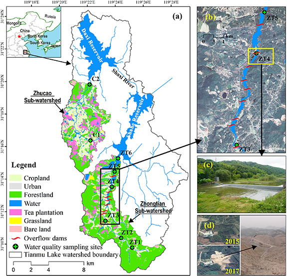
Figure 1. (a) Map of Tianmu Lake watershed with locations of Daxi and Shahe Reservoirs. Land cover as of 2018 is shown for the Zhongtian and Zhucao catchments. Water quality sampling sites (abbreviated ZT and C, for the Zhongtian and Zhucao catchments, respectively) are indicated, as are overflow dam locations. (b) Detailed aerial map of a portion of the Zhongtian catchment with locations of overflow dams and river wetlands. (c) The restored wetland adjacent to the overflow dam at site ZT4. (d) Photos of a site in the Zhongtain watershed that was forest in 2015 and cleared for tea cultivation in 2017. The enlargement to the right underscores the extent of land clearing (see also figure 1S (available online at stacks.iop.org/ERL/15/084030/mmedia)).
Download figure:
Standard image High-resolution imageChanges in cropland, urban and other categories of land use during 2009–2018 were comparatively modest in both watersheds, but forest-to-tea conversion was disproportionately significant for both watersheds (figure 2), confirming that rapid tea expansion is a common feature. Tea plantation area increased in the Zhongtian watershed by 230% in just 10 years—from 98 ha in 2009 to 323 ha in 2018. The corresponding figures for the Zhucao watershed are 539 ha in 2009 and 773 ha in 2018, a 44% increase. Thus, about 220 ha of newly cultivated tea plantations were added in both watersheds during the 2009–2018 interval, with a corresponding decline of forest area. It should be noted that such forest-to-tea conversion can lead to long-lasting impairment of soil and water quality, including reduction of water purification and other ecosystem services that forest ecosystems provide (García-Llamas et al 2019). The subsequent cultivation is associated with intensive fertilizer applications and periodic pruning of tea plants, which usually results in exposure of a large area of bare land at the onset of the rainy season (Han et al 2012). This and previous information (Zhang et al 2019a, 2019b) provides evidence that tea expansion, although comprising only a small portion of the watershed areas, is one of the most prominent drivers of water quality changes in both.
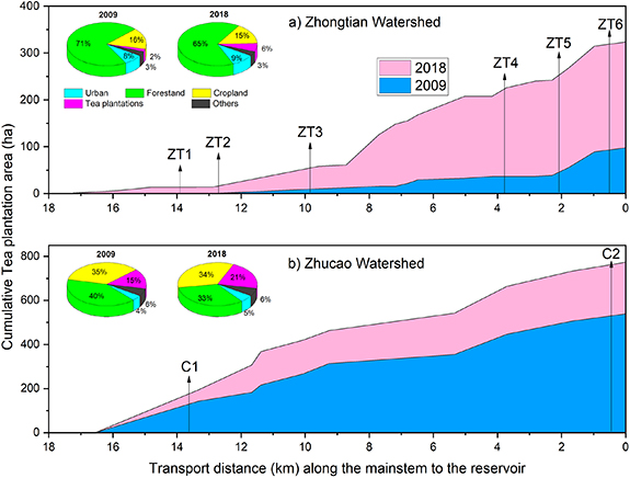
Figure 2. Upstream-to-downstream expansion of tea plantations in the drainage areas along the mainstem river in the (a) Zhongtian and (b) Zhucao watersheds. Note that the corresponding pie charts indicate land use for 2009 and 2018 for each watershed.
Download figure:
Standard image High-resolution imageThe Zhucao River, which served as a control site to assess the effects of engineered structures on riverine improvement of pollutants, was not modified in any way. In contrast, nine overflow dams were installed in the mainstem of the Zhongtian River in 2009, and aquatic plants were planted in the resulting river cascade wetlands in the riparian and lower river reaches (see figure 2S). The growth of these aquatic plants was promoted by relatively stable water levels due to overflow dams and high nutrient concentrations from the upstream watershed. The restored wetlands provide habitat for fish and other species, resulting in enhanced biodiversity; because they are outfitted with fish passageways, fish can swim up and down the river (figure 3S). Thus, the engineered overflow dams and cascade wetlands are ecologically based and capable of enhancing other ecosystem services, including recreation and tourism (Bergen et al 2002, Mitsch et al 2002, Mitsch and Jørgensen 2003).
2.2. Data collection and analysis
Six monitoring sites in the Zhongtian watershed, identified from upstream to downstream as ZT1–ZT6, and two sites in the Zhucao watershed (C1 and C2) were monitored monthly from January 2009 to December 2018 (figure 1(a)). TN, TP, permanganate index (COD), and total suspended solids (SS) were analyzed following the standard protocol (MEP 2002).
Streamflow at site ZT4 was obtained from a hydrology gauge station, while streamflow values for other sites were estimated using the HSPF model (see Li et al 2015, Zhang et al 2019a for details). Annual land use data at 5 m resolution (2009–2018) were used to monitor land use transformations in the two sub-watersheds (see figure 4S).
2.3. Statistical methods
We adopted the SMK test to determine whether monotonic (i.e. single-direction) trends in water quality parameters exist over the monitoring interval. This nonparametric test is widely used to examine trends in environmental data, because it can accurately reconstruct trends without the requirement of normal data distribution (Helsel and Frans 2006). Sen's slope (Sen 1968), which is computed as the median of all slopes from observations in the same season, was used to evaluate the magnitude of trends. The sign of Sen's slope can indicate the major direction of the temporal trends, and the p-value was used to assess the statistical significance of trends.
Temporal variability of streamflow could impact water quality trends, and so we conducted another SMK analysis using streamflow as a covariate of the test (Helsel et al 2006). Comparison of differences of statistical significance between the two sets of tests, as indicated by p-values, facilitated evaluation of the role of streamflow on water quality trends.
SMK detects single-direction trends and is not designed to discern trend reversals or visualize trends at sub-monthly scales. Such information is nevertheless important to assess performance of the engineered system, because the capacity of wetlands to process nutrients is subject to seasonal dynamics. We thus employed STL, a quantitive method for time series analysis, to describe nonlinear patterns and seasonal interactions in time-series data (Cleveland et al 1990). The method uses an iterative nonparametric regression with repeated loess fitting to decompose the time series into seasonal (cyclic) and long-term trends with a remainder term (Cleveland et al 1990). This provides important information about water quality, including temporal patterns that cannot generally be detected with traditional trend techniques (Lloyd et al 2014).
As with other nonparametric regression methods, STL requires subjective selection of window widths of the seasonal and long-term smoothing parameters (Cleveland et al 1990). Using previous recommendations and diagnostic methods (Cleveland et al 1990, Romero et al 2016), we selected window widths of 6 months and 48 months, respectively, to elucidate trends. All analyses were performed in R, an open-source statistical programming language (https://www.r-project.org).
3. Results
3.1. Overall trends and the influence of streamflow
Summary statistics from the SMK analysis are presented in table 1. Worsening or nonsignificant trends were observed at sites ZT1, ZT2 (except TN), C1, and C2, which all drain from regions with substantial agricultural production without any in-stream engineering. Annual increases in TN, TP, and, SS at site C2, for example correspond to 3.7%, 4.4%, and 4.3%, respectively, of their multi-year averaged concentrations. Some intermediate sites, such as ZT3–ZT5, showed significant variability in water quality trends, however site ZT6, which lies below the engineered structures, experienced uniformly improving trends. Average annual reductions of TN, TP, and SS at this site were 1.1%, 0.5%, and 4.0%, of multi-year averaged concentrations, respectively.
Table 1. Trend magnitudes for Sen's slope (S, in mg l−1 yr−1) for four water quality indicators from 2009 to 2018. Two categories of 2-sided p-values are indicated: p = the standard value, and pc = the value corrected for monthly streamflow covariate. Nonsignificant p-values at the 10% level are designated NS.
| Site | TN | TP | COD | SS | ||||||||
|---|---|---|---|---|---|---|---|---|---|---|---|---|
| S | p | pc | S | p | pc | S | p | pc | S | p | pc | |
| ZT1 | 4.57 × 10−02 | NS | NS | 8.19 × 10−04 | NS | NS | 2.74 × 10−04 | NS | NS | 9.57 × 10−01 | 0.00 | 0.01 |
| ZT2 | −3.43 × 10−02 | NS | 0.02 | 2.36 × 10−04 | NS | NS | −1.49 × 10−02 | NS | NS | 1.28 × 10+00 | 0.00 | 0.00 |
| ZT3 | 6.83 × 10−03 | NS | NS | 1.87 × 10−03 | 0.00 | 0.00 | −1.25 × 10−02 | NS | NS | 7.83 × 10−01 | 0.01 | 0.02 |
| ZT4 | −3.59 × 10−02 | NS | 0.01 | −4.41 × 10−04 | NS | NS | −1.58 × 10−02 | NS | NS | 2.85 × 10−01 | NS | NS |
| ZT5 | −9.06 × 10−03 | NS | NS | 1.65 × 10−03 | 0.01 | 0.02 | −4.58 × 10−03 | NS | NS | 7.90 × 10−01 | 0.05 | 0.07 |
| ZT6 | −1.71 × 10−02 | 0.08 | 0.00 | −2.37 × 10−04 | NS | NS | −2.90 × 10−02 | NS | NS | −6.73 × 10−01 | 0.03 | 0.00 |
| C1 | 1.15 × 10−01 | 0.00 | 0.05 | 7.48 × 10−03 | 0.00 | 0.00 | −5.40 × 10−02 | NS | 0.04 | 5.87 × 10−01 | NS | NS |
| C2 | 6.72 × 10−02 | 0.00 | NS | 2.58 × 10−03 | 0.00 | 0.01 | 1.15 × 10−03 | NS | NS | 6.64 × 10−01 | 0.00 | 0.06 |
When monthly streamflow was adopted as a covariate in the SMK tests, there was virtually no change in the significance of p-values (table 1). This demonstrates that general trends of water quality do not appear to be strongly impacted by fluctuations in streamflow, which implies that they are more likely due to other factors such as agricultural expansion and enhanced in-stream retention. Overall, SMK analysis: (i) highlights the sensitivity of pollution indicators to changes in land use, primarily expansion of tea, (ii) documents the overall improved trends at the site below the engineered structures, and (iii) shows that it unlikely that streamflow is a major factor in the above considerations.
Water quality may nevertheless be influenced by abnormal streamflow in extreme years, which are normal components of natural variability (Qian et al 2000). STL analysis of streamflow at site ZT4 in the middle reach of Zhongtian River provides an example of this effect (figure 5S). Streamflow was consistently higher in summer, and its seasonality did not change significantly over time, except for an obvious peak in 2016. It is thus important to consider systematic influences of the magnitude and seasonality of streamflow on water quality trends, particularly for 2016 which was an extreme year, as riverine pollutant concentrations are related to streamflow.
3.2. Annual and spatial trends in water quality
Long-term water quality trends are shown in figure 3 for the two contrasting watersheds from STL analysis. The upstream-to-downstream spatial pattern of nutrient pollution in the two watersheds is similar; i.e. levels of both nutrients were greater at the uppermost sites than at sites farther downstream. Relatively higher nutrient levels at the most upstream stations ZT1 and C1 suggests that nutrient loss is sensitive to human disturbance, because the thin soils, steep terrain and low vegetation cover in their drainages usually promote nutrient transport and thus magnify environmental consequences (Dai et al 2017, Macintosh et al 2018, Lai et al 2020). The generally progressive decline of upstream-to-downstream TN concentrations in the Zhongtian watershed is less smooth for TP; concentrations dropped abruptly between sites ZT2 and ZT3 (below the overflow dam; see figure 1(b)) and then leveled off. Concentrations of both nutrients were substantially reduced—by 50% and 40%, respectively, for TN and TP. Reductions of 35% and 30%, respectively, for TN and TP—were also evident in the Zhucao watershed. In short, both watersheds experienced upstream-to-downstream reductions in TN and TP, even though land disturbance (figure 2) and nutrient loads (Zhang et al 2019a) became progressively greater as elevation decreased. The presence of engineered structures in the Zhongtian watershed is correlated with enhanced removal of nutrients relative to those in the free-flowing Zhucao River, where only natural processes (e.g. dilution, sedimentation, vegetative uptake, and denitrification) were operative from upstream to downstream.
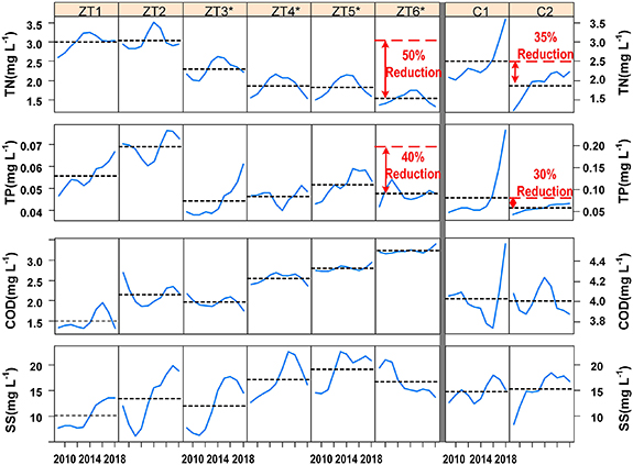
Figure 3. STL long-term trend lines (seasonal component removed) for TN, TP, COD, and SS concentrations (in mg l−1). Columns are arranged to depict upstream-to-downstream relationships from left to right. Dashed lines represent the long-term, multi-year mean for each site. Zhongtian sites marked with an asterisk are within the area containing the installed ecological engineered system.
Download figure:
Standard image High-resolution imageAnnual fluctuations of varying magnitudes from 2009 to 2018 are apparent at each site (figure 3). Spatial trends in the two watersheds nevertheless differ, with TN, TP, and COD showing strong upward trends in the Zhucao watershed. Although indicators from many Zhongtian sites are characterized by time-dependent variation of modest magnitude with no consistent upward or downward trend, some rising trends (for example, TP at sites ZT1 and ZT3) are evident. Comparison of site ZT3 to its three downstream sites is noteworthy. Nutrient concentrations at site ZT3 were higher in 2018 than in 2009 (except COD)—especially for TP. Irrespective of annual fluctuations, pollution levels at lower elevation sites were generally reduced, in spite of the significant agricultural expansion in the incremental watersheds (figure 2).
In contrast to nutrient concentrations, COD and SS levels trended upward along the upstream-to-downstream continuum in the Zhongtian watershed, but similar patterns were not apparent in the Zhucao watershed. This is similar to other research, which has also found that wetlands contribute to organic matter, reducible inorganic ions, and other suspended particulate matters in rivers (Díaz et al 2008). It is notable that in contrast to levels of SS at upstream sites on the Zhongtian River, the level of SS at site ZT6 generally decreased from 2009 to 2018. This suggests that, after a series of interceptions by dams and wetlands, increasing trends were reversed. It is also worth noting that SS levels at many sites peaked in the wet year (2016), but not at site ZT6. This indicates that engineered structures can buffer the effects of unusually high precipitation on SS levels.
3.3. Seasonal trends in water quality
We complemented the above annualized analysis of pollution in the two watersheds by comparing seasonal variation in concentrations of four pollutants at three sites representative of the upstream (ZT1), midstream (ZT3), and downstream (ZT6) areas of the engineered Zhongtian watershed and the non-engineered Zhucao watershed (figures 4 and 5). Long-term mean concentrations of TN are seasonally highest during the cold winter months (December through February) at all Zhongtian sites, reaching levels as much as three times those during mid-summer, when vegetative growth and denitrification occurs (figure 4). Except during winter, the magnitudes of year to year, within-month fluctuations of TN at sites ZT1 and ZT3 (below the uppermost overflow dam) were exaggerated compared to those at site ZT6 (below the entire engineered structures). Levels of TN at site ZT6 were almost always lower than corresponding levels at the other two sites. Seasonal patterns of TN levels in the Zhucao watershed diverged from those in the engineered watershed. The upstream C1 site had increasing year to year trends in all 12 months; these trends persisted in 10 of 12 months at downstream site C2.

Figure 4. Seasonal patterns of long-term trends in TN and TP concentrations (in mg l−1) at three sites in the Zhongtian watershed and two in the Zhocao watershed. Each column depicts the long-term trend for a given month, with a dashed line representing the month's long-term mean.
Download figure:
Standard image High-resolution image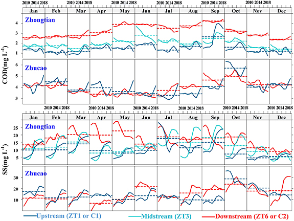
Figure 5. Seasonal patterns of long-term trends in COD and SS concentrations (in mg l−1) at three sites in the Zhongtian watershed and two in the Zhocao watershed. Each column depicts the long-term trend for a given month, with a dashed line representing the month's long-term mean.
Download figure:
Standard image High-resolution image
Although long-term mean concentrations of TP were relatively uniform from month to month in the Zhongtian watershed, a sharp rise occurred in September. The magnitude of the rise generally increased between 2009 and 2018, likely due to heavy fall fertilizer applications (Han et al 2012) to tea plantations that were expanding during this interval. With the exception of September, there were only small fluctuations between months at site ZT1. As was the case for TN, seasonal patterns of TP levels in the Zhucao watershed differed from those in the engineered Zhongtian watershed (figure 4). Within-month TP levels at site C1 were relatively constant from 2009 until 2016, when they rose sharply in every month, leading to nearly superimposable curves. A rise in within-month TP levels was also apparent at site C2, but with a less consistent rise across months. Although TP concentrations were generally higher at site C1 than at site C2, they rose by two- to three-fold after 2016.
In comparison to other pollutants, long-term mean monthly concentrations of COD and monthly variations in these concentrations were relatively level in both watersheds (figure 5). Upstream-to-downstream mean monthly concentrations nevertheless trended upward in the summer in the Zhongtian watershed, with corresponding declines in monthly variations from 2009 to 2018. In contrast, mean monthly concentrations of COD remained constant or decreased slightly during the summer in the Zhucao watershed. A September spike in COD concentrations during 2016 (a wet year) was apparent only at sites ZT1 and ZT2.
Long-term monthly mean concentrations of SS in the Zhongtian watershed varied approximately five-fold and tended to be lowest during the winter months (figure 5). The pattern of within-month fluctuations between sites differed above and below the engineered structures. Increases, often as S-shaped curves, predominated at sites ZT1 and ZT3, but decreases, often as reverse S-shaped curves, predominated at site ZT6. This suggests that the engineered structures reduced levels of SS downstream when SS levels upstream were increasing, and thus elevated levels of SS would be expected (Bilotta and Brazier 2008). Variations in both long-term mean concentrations of SS and within-month fluctuations of SS were also apparent in the Zhucao watershed, but the patterns diverged from those in the Zhongtian watershed and were less uniform. Note that peaks in levels of SS were apparent in most months of 2016, a wet year, in both watersheds, except for the site ZT6.
4. Discussion
4.1. Importance of enhanced in-stream retention
In recent decades, ongoing conflicts between agricultural expansion and needs of a high-quality environment widely persist and are typically magnified in fragile hilly watersheds (Matson et al 1997, de Jesús-Crespo et al 2016, Lv et al 2016). This study presents a real-world demonstration that conflicts can be effectively reconciled using ecologically based practices. Overflow dams and cascade wetlands offer significant advantages for intercepting nutrients and improving water quality (Bergen et al 2002, Mitsch and Jørgensen 2003) in hilly watersheds, where lack of in-stream nutrient processing is a limiting factor and where impacts of human activities are substantial (Macintosh et al 2018, Pueppke et al 2019).
Our 2009–2018 comparison of two similar sub-watersheds demonstrates (figures 3–5) ecological engineering may provide an effective means to reduce nutrient loads to Tianmu Lake. In contrast, there have been deteriorating nutrient concentrations in the non-engineered Zhucao watershed (see table 1), where average annual reductions in TN, TP, and SS at site ZT6 were ∼0.5%–4.0% of their multi-year averaged concentrations. These reductions occurred despite significant land use conversion (see figure 2), which highlights the value of in-stream retention engineering to reduce pollutant levels and help reconcile agricultural development and environmental protection. It is important to note that no two sub-watersheds are identical. Variations in land use patterns and average slope are apparent in the Zhongtian and Zhucao sub-watersheds (see table 1S), which can exert differential effects on transport of pollutants and water quality. This adds a degree of uncertainty that is relevant both to the Tianmu watershed and to understanding the usefulness of engineered structures in watersheds elsewhere.
4.2. Mechanisms and benefits of enhanced in-stream retention
Water temperature is an important factor that contributes to patterns of nutrient removal (Verhoeven 2009), and thus it would be expected that dams and wetlands in the Zhongtian watershed preferentially reduce nutrient loads during the warm season, when vegetative growth and denitrification are active (figure 4). Such seasonal performance protects the downstream lake during the most sensitive months, when algal blooms are most likely (Carpenter 2005).
Contrasting trends in TN concentrations observed at sites C2 and ZT6 and more obvious upstream-to-downstream reductions observed at the engineered river reach (figures 3 and 4) indicate that the engineered structures likely created a hotspot for denitrification, a process that usually accounts for the majority of TN removal in aquatic ecosystems (Saunders and Kalff 2001, Ator and Garcia 2016). The efficiency of denitrification is known to be enhanced in such hotspots, which elevate biogeochemical activity by increasing in-stream residence time (Akbarzadeh et al 2019). Dams and wetlands can contribute to additional N processing, including mineralization and nitrification (Vymazal 2007), which when coupled with denitrification, transform TN into bioavailable forms that can be permanently removed from the aquatic ecosystems (Zubala 2009). Overflow dams also stabilize water levels and attenuate velocities to enhance survival of desirable aquatic plants, especially during flooding periods (Deegan et al 2012). This helps to promote TN assimilation, uptake, and interception, although much of the retention was subject to temporary storage (Saunders and Kalff 2001).
Attenuated flow velocities and dense stands of aquatic plants also promote sedimentation, which facilitates nutrient assimilation and retention (Verhoeven 2009, Akbarzadeh et al 2019). The significant reductions in TP concentrations between sites ZT2 and ZT3 show this phenomenon (see figure 3), but the lack of parallel reductions in SS levels indicates that larger, easily deposited particles (also enriched with TP) likely preferentially settle behind the first overflow dam. It is notable that TP and SS levels continuously increased along the river sections between sites ZT3 and ZT5 (figure 3). This may be due to incremental contributions, because there are large areas of tea expansion within the incremental watersheds draining to these sites (figure 2). As other dams and wetlands further attenuate flow speeds in lower reaches, levels of TP and SS began to decrease, indicating that the enhanced retention capacity of the system may exceed the incremental contributions. Incremental supply can nevertheless fluctuate widely, and the retention capacity of such systems can be highly variable in time. Revealing the complicated mechanisms behind TP and SS changes in such systems would require process-based monitoring and modeling.
Wetlands are usually associated with high levels of net primary production (Gao et al 2014), but elevated carbon (C) pools in wetlands, which also increase COD levels (Díaz et al 2008). This is most evident in the warm season, when primary production and microbial activity are both high (Briggs et al 1993). In fact, COD levels rise in the engineered Zhongtian River system, coinciding with periods of high primary production during the warm season (figure 5). High COD levels are evidence of pollution, but they also may promote TN removal, because organic C is one of the most important controlling factors for denitrification (Mulholland et al 2008). Although optimized hydrological controls can reduce COD levels (Saunders and Kalff 2001, Akbarzadeh et al 2019), the relationship between COD, nutrients, and engineered structures is complicated and warrants additional investigation.
4.3. More integrative management is required
In addition to buffering the effects of runoff from agricultural lands and generally elevating water quality, engineered structures such as those on the Zhongtian River are also low cost and maintenance-free. They enhance ecosystem services (e.g. recreation and tourism) and can improve fish and other species habitat provided that overflow dams are designed for fish passage (figure 3S). The retention efficiency of the dams and wetlands is nonetheless limited (Vymazal 2007), and the water quality in the outlets of wetlands does not necessarily meet drinking water standards. This is the case at the outlet of the engineered structures below site ZT6, where monthly TN concentrations are frequently more than 50% higher than the national standard of 1.0 mg l−1 (MEP 2002). Monthly TP concentrations are clearly higher than the TP threshold of eutrophication (∼0.02 mg l−1, Correll 1998), and also do not meet the national standard (0.05 mg l−1, MEP 2002). Nutrient pollution consequently continues to be a pressing problem in this system.
Controlling agricultural expansion, which increased by 231% and 44%, respectively, in the Zhongtian and Zhucao watersheds between 2009 and 2018, remains a priority. However, economic incentives, which have driven the price of tea in the Tianmu Lake watershed to as much as $600 per kg (Zhang et al 2019a), hold great sway over expansion of tea plantations. This makes it difficult to limit fertilization levels and loss of forested land. Increased taxation on land exploitation may be necessary to raise funds for environmental restoration activities. Legislation to restrict agricultural activities in sensitive areas, such as the 'Grain for Green' program (Rozelle 2005) could also be strengthened. In the meantime, integrative management efforts, including construction of engineered structures, should be intensified to reduce nutrient inputs and enhance nutrient retention during land-to-water delivery (Pueppke et al 2019).
Acknowledgments
This study was financially supported by the Ecological Civilization Project Towards A Beautiful China (XDA23020403), the Active Design Project for Agricultural and Social Development in Hangzhou, Zhejiang Province (20180417A06), the Thirteenth Five-Year Plan of the Nanjing Institute of Geography and Limnology (NIGLAS2018GH06), the National Natural Science Foundation (41701040 and 41877513), and the Natural Science Foundation of Jiangsu Province of China (BK20171100). The authors wish to express their gratitude to the Asia-Hub Program (No. 2017-AH-10) for funding the visiting venture that led to this paper, and to the reviewers for their valuable comments.
Data availability statement
The data that support the findings of this study are available from the corresponding author upon reasonable request.