
Abstract
A combined petrographic, mineralogical, and geochemical characterization of the lateritic hardpan deposits of Bamendjou was carried out. The purpose was to better understand the process of laterization in a view to facilitate the broad use of this deposit in building applications. The petrographic analysis reveals the presence of protopisolithic, massive, and nodular facies. On the basis of the results provided by X-ray diffraction (XRD), these facies are composed of such phases as gibbsite, goethite, hematite, anatase, and kaolinite. In addition, boehmite has been found in the massive and protopisolithic facies, whereas gibbsite and magnetite frequently occupy the nodular facies. Whole-rock geochemical data indicates that a alumina represents the most abundant oxide in the protopisolithic and the massive facies (46.78–51.63 wt.% and 42.85–43.45 wt.%, respectively). It is followed by relatively high content of iron 12.93–18.33 wt.% and 23.43–23.78 wt.%, respectively) accompanied by very low contents of silica 1.44–2.75 wt.% and 2.44–3.99 wt.% of SiO2 respectively) and titanium 3.70–47.0 wt.% and 4.00–5.30 wt.%, respectively). Iron is the most abundant chemical element in the nodular facies since it ranges from 49.64 to 58.58 wt.%. The petrographic, mineralogical and geochemical geochemical (especially the high iron content) features suggest that the lateritic duricrust of the Bamendjou area have good potential to be utilized in stonework in buildings (bricks).
1 Introduction
Lateritic soils occupies one third of the intertropical zones [41] and is developed essentially in dry tropical climates with contrasted seasons [7, 46]. These soils are developed in the tropics through the process of weathering which favors the formation of iron, aluminum, manganese and titanium oxides. Iron and aluminum oxides are prominent components in lateritic soils and with the seasonal fluctuation of the water table, these oxides results in the formation of lateritic hardpans, which can be observed within the weathering profile. The African continent is typically abundant with lateritic soils and lateritic hardpans and in certain areas these have been exploited for minerals (bauxite, iron, manganese, [25]). Bauxite constitutes the mineral ore most exploited industrially. In Cameroon, many studies were carried out on lateritic hardpans particularly that of Adamaoua [42] and the Bamiléké plateau [19, 27, 40, 47]. On Bamiléké plateau, the essential studies were concentrated on the lateritic crust of Fongo-Tongo and Bangam which extends to other areas such as Fokoué, Doumbouo, Loung-Ndô and Meletan [26]. Interestingly, Bamendjou which is located in the North-West of Bangam has not been the subject of studies as has been Fongo-Tongo and Bangam. The lateritic hardpans here, is a continuity of those found in Bangam and hence developed on the same basaltic substratum. Some other studies [20, 22, 27, 34] have given some applications of laterites. However, no proper use of a material can be envisaged without its proper characterization. Therefore, the aim of this study is to present a detailed mineralogical and geochemical data of lateritic hardpans from Bamendjou (Western Cameroon) and determine their potential industrial applications.
2 Materials and methods
2.1 Natural framework of the study
The studied site is located in Bamendjou, which is at the heart of the Bamiléké Plateau between longitudes 10° 15′ and 10° 30′ East and latitudes 5° 15′ and 5° 30′ Northern. This area belongs to the Western Highlands of Cameroon, which corresponds to a portion of the old Precambrian base, renovated and deformed during Panafrican tectonic event. Tectonics and volcanism are the main geological features of the Western Highlands [30]. The landscape consists of several interfluves with convex slopes, which in some places present themselves as soft inclined projecting ledges connected to talwegs. According to the digital elevation model, the average altitude of the terrain lies between 1400 and 1600 m. (Fig. 1). The highest altitudes are greater than 1650 m and are located in the South-west of study area and at the same elevation as that of the lateritic hardpans of the Bangam plateau. Thereafter it decreases progressively towards the North-East, which is towards Bafoussam while passing through Bamendjou. Geologicaly, the mantle of the zone of study was developed on basalts (Fig. 2), which were emplaced in the form of pillow lava and could be classified as “plateau basalt’’ [33]. Their origin is linked to a system of fractures of major direction N 30°. These fractures are circumscribed in a band approximately 100 km wide over more than 1600 km long called the “Cameroon volcanic Line” [17]. Their age is generally attributed to the Cretaceous or the beginning of the Tertiary age [23]. These basalts are indicative that they have alkaline or transitional affinities [15] and exhibit a porphyritic and aphyric microlitic texture. Microscopic studies show an olivine and clinopyroxene basalt consisting of olivine (25%), augite (23%), apatite (23%), bytownite (17%), magnetite (5%), ilmenite (4%) and diopside (3%). The lateritic gravel of Bamendjou can therefore be classified as “true laterites” and are made up averagely of kaolinite (11%), goethite (67%), ilmenite (4%), magnetite (7%) and corundum (11%) [31].

Digital ground elevation model of Bamendjou

Geological map of the study area
Pedologicaly, two great soil types can be distinguished in the area. These are the ferralitic soils found at the top of the plateau and on the hillsides, as well as hydromorphic soils found in the lowlands and consisting of minerals and organic matter. Bamendjou is drained by the watershed of the Mifi-south with a subparallel drainage pattern. The average annual precipitation of 1618.18 mm is associated with the average annual of temperature of 20.8 °C, which are typical of wet tropical climates. The vegetation is an anthropic savanna known as the Grassfield of Western Cameroon. Afforestation is actually done by cultivating eucalyptus, which is well adapted to the local soil and climatic conditions.
2.2 Materials and methods
To attain the objectives, an examination of the landscape was carried out, with a detailed soil profile carried out, as well as thin sections performed on specimens of the lateritic hardpans of Bamendjou. The landscape was studied by an identification of the principal plateau and different hardpan facies. Two samples of the various hardpan facies were taken from the field and subjected to petrographic, mineralogical, and chemical analysis. The petrographic analysis of the different hardpan facies was made at a macroscopic scale by a visual observation and at the microscopic scale with the assistance of an electronic microscope of Leica made (DM 750, X 40).
The analysis of the mineralogical phases was performed by X-ray diffraction (Bruker D8 Advance diffractometer) using monochromatic Cu Ka radiation with 26 ranges of 2°–70° in steps of 0.020° operated at 40 kV and 25 mA using Cu-Kα1 radiation (I = 1.5406 A). The interpretation of the mineral phases was carried out using the appropriate criteria according to [9] with the aid of the EVA software. The qualitative and semi quantitative estimates [6] (± 5–10%) were based on the heights of the diagnosed peaks multiplied by the appropriate correction factors [8, 11] and the mineral abundances were normalized to 100%. For semi-quantification of the different clay minerals, estimates of kaolinite, illite, and chlorite were based on the height of 001 reflections (at 7, 10 and 14 Å, respectively) with correction factors of 0.7, 1.0 and 0.34 respectively [14]) on glycolated specimens.
The chemical composition of the whole-rock samples was obtained from X-ray Fluorescence spectrometer located at the Petrology Laboratory of the University of Liege. The sample (0.34 mg) which was previously calcined at 1000 °C was mixed with KBr (0.34 mg × 11), LiBr (0.0002 mg) and fired again to form pellets. The spectrum of major oxides in each sample was obtained by X-ray fluorescence spectrometry, and these help to determine the relative abundance of each element in the sample [35, 38].
3 Results
3.1 Distribution of the hardpan facies on the landscape
Principal hardpan surfaces were found in Kong-Dang, Kong-T’honta, Kong-Mboum, Kong-Kang and Kong-Chi. These consist of three types of petrographic facies:
-
The protopisolith facies, which were found at altitudes higher than 1620 m and principally at Kong-Kang, Kong-Mboum, Kong-Ndji, as well as the top of the interfluve of Kong-T’honta;
-
The massive facies situated at altitudes ranging between 1580 and 1620 m in Kong-Dang;
-
The nodular facies occupying the slopes of Kong-T’honta and at altitudes lower than 1580 m.
An observation of trial pits on the slopes of these interfluves shows similar facies from the top surface towards the depths. At the pedological level, the profiles are made up of: a disturbed horizon of fine gravels; a horizon of a block of hardpans in an argillaceous matrix associated with fine gravels; an argillaceous horizon of yellowish to grey color and a horizon of basalt undergoing weathering (Fig. 3).

Typical illustration of the weathering mantle of Bamendjou on the slopes. Key Disturbed horizon (B1); crust horizon (B2); argillaceous horizon (B3); weathered bedrock (C)
3.2 Petrography of the facies
On the basis of the classification proposed by [41], the following facies were identified and subjected to a petrographic study:
-
A thin section carried out on the massive facies presents a deep reddish color (10R4/6) (Fig. 4a), with some sub-spherical millimetric cavities, having a heterogeneous matrix at the top but disorientated at the base. Microscopically, it presents a dark red ferruginous plasma on which one observes some whitish crystalic plasma developed around the microlitic cavities or voids. The disturbed matrix presents yellowish cutanic zones (Fig. 4b).
Fig. 4 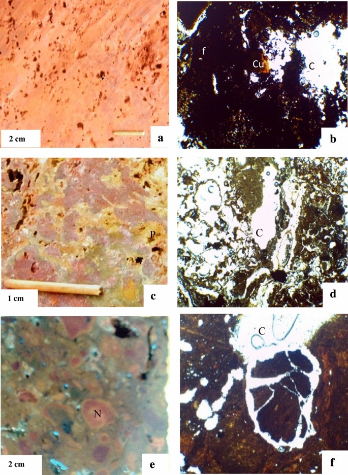
Macroscopic and microscopic organization of hardpan facies. F clay rich plasma with ferruginous matrix, C crystal rich plasma with gibbsite, P protopisolith, Cu cutane, N nodule. a Massive duricrust facies; b microscopic view of the massive duricrust facies; c protopisolithic duricrust facies; d microscopic view of the protopisolithic duricrust facies; e nodular duricrust facies; f microscopic view of the nodular duricrust facies
-
A thin section carried out on the protopisolithic facies presents a matrix of very deep purple-red color (10 YR 3/6) (Fig. 4c) sectioned by protopisolithic of yellowish color (7.5YR7/6), developed around cavities of millimetric sizes. Microscopically (Fig. 4d), the slightly disturbed matrix presents crystal plasma developing around the voids.
-
A thin section carried out on the nodular facies present some nodules with very deep reddish color (10 R 4/6) (Fig. 4e), as well as light red (2.5 YR 3/2) across which are millimetric inter nodular cavities. Microscopically, it presents a light matrix dissected by a network of crystal-rich plasma filling the voids. (Figure 4f).

3.3 Mineralogy of the facies
Table 1 presents the mineralogical composition of the various facies.
From the mineralogical perspective, the minerals presented in all facies are represented by: gibbsite, goethite, hematite, anatase and kaolinite. In addition, boehmite was encountered in the massive and protopisolithic facies, while trace amounts of magnetite were found in the nodular facies. Gibbsite with characteristic peak of 4.83 Å represents the most abundant mineral phase of massive (61.11–62.99%) and protopisolithic (66.40–70.07%) facies (Fig. 5). Goethite is also significant and represents (10–20)% of minerals detected by X-ray. The predominant mineral of the nodular facies is goethite, though amounting to only (58.1–61.71)% of minerals detected by X-ray, marked by a major peak appearing at 4.16 Å. Gibbsite is the second most abundant mineral in these facies and this represents (16.66–29.33)% of minerals detected by X-ray. Additionally, trace amounts of magnetite (2.56 Å) were detected in nodular facies (2.86–3.20%). The analysis of the argillaceous fraction (Fig. 6), revealed that kaolinite is the only clay-group mineral recognized with the peaks at: 7.1 Å (Nodular); 7.17 Å (Massive) and 7.19 Å (Protopisolithic).

XRD patterns of lateritic hardpans of Bamendjou. Kln kaolinite, Boe boehmite, Gi gibbsite, Goe goethite, He hematite, An anatase, Mag magnetite, B and K1 protopisolithic facies, D and T2 massive facies, M and T1 nodule facies

XRD patterns of the oriented < 2 µm fraction of the clay sample: air-dried (N), ethylene glycol (EG), and heat treated (500 °C). B (protopisolithic facies), T2 (massive facies), T1 (nodule facies)
3.4 Geochemistry of the different facies
Table 2 below presents the chemical composition of facies.
From Table 2 it may be inferred that chemical composition of various facies shows remarkable differences. Alumina is the most abundant oxide in the protopisolith (46.78–51.63 wt.%) and massive facies (42.85–43.45 wt.%), This is followed by a relatively high content of iron oxide ((12.93–18.33)% and (23.43–23.78)% of Fe2O3 respectively) and very low content of silica ((1.44–2.75)% and (2.44–3.99)% of SiO2 respectively), then titanium ((3.70–470)% and (4.00–5.30)% of TiO2 respectively). Iron is the most abundant chemical element in the nodular facies with (49.64–58.58)% of Fe2O3. On the other hand, the loss on ignition (LOI) shows high values in the protopisolith (26.44–29.35)% and massive (23.58–25.28)% facies, as compared with the nodular facies (16.13–19.72)%.
3.4.1 Matrix of correlation between the minerals and the major oxides
Table 3 presents the data correlation by the Pearson coefficient between the minerals and the major oxides.
High correlation − 0.7 to − 1 and 0.7 to 1; average correlation − 0.5 to − 0.7 and 0.5 to 0.7; lower correlation 0 to − 0.5 and 0 to 0.5.
It arises from Table 3 that:
-
The gibbsite shows a strong positive correlation with aluminum and the loss of ignition (LOI) characterized by a coefficient of correlation respectively of (r = + 1) and (r = + 0.99). It also shows a strongly negative correlation (r = − 0.99) with iron oxide.
-
Kaolinite presents a strongly negative correlation (r = − 0.89) with alumina and a strongly positive correlation with silica (0.89) and oxides according to: MgO (r = + 0.81); CaO (r = + 0.73); K2O (r = + 0.88).
-
As for the goethite and hematite, the correlation is averagely positive with iron and is characterized by a coefficient of correlation respectively of (r = + 0.55) and (r = + 0.62).
-
The anatase shows a strong correlation with titanium oxide, with a coefficient of correlation of (r = + 0.86).
4 Discussion
The study area falls within the intertropical zone and consequently is typically marked by the development of a thick weathered mantle resulting from the surface transformation/alteration of the parent rocks of the lithosphere due to the influences of climatic [12]. This weathered mantle is encountered at shallow depths, and even at certain places-it crops out to the surface as blocks of lateritic hardpans resulting from the direct transformation of basalt [21, 23]. These all belong to the lateritic hardpans of the Western Highlands of Cameroon, which are located preferably on fissural volcanic effusions [29]. The lateritic hardpans of Bamendjou are situated at the level of plateau with flat-topped or slightly wavy and rounded peak interfluves. In general, these lateritic hardpans are more often attached to the stepped flattened surfaces of slopes located at elevated positions on the landscape [3].
In the study area, the lateritc hardpans are continuous and laid out in several layers with the thickest layer outcropping as a slab and as jointed blocks located at altitudes higher than 1580 m. These altitudes are higher than those found in the environs of Ngaoundéré (1200–1400 m) and at Foumban (1100–1200 m) [13, 44]. Then, at the intermediate layer the hardpans are made up of non-jointed blocks with fine gravels in-between them, and all these are located at altitudes between 1560 and 1580 m. These are often termed as sloped hardpans. Their discontinuous nature is generally attributed to in situ degeneration of initial hardpans [3, 28, 39]. At the lower layer these hardpans consist of fine gravels and are located at altitudes going from 1540 m to more than 1560 m. These fine gravels are breakdown products of the hardpans due to plant actions.
Such an altitudinal succession of hardpans was also described by Eno Belinga [13] in the Ngaoundere area, with continuous hardpans at altitudes between 1200 and 1400 m and discontinuous hardpans on plateaus at altitudes between 900 and 1100 m associated with loose reddish ferraltic soils. At altitudes higher than 1670 m these hardpans correspond with those of the hardpans of the Bangam plateau, which falls within or belongs to the indurated laterites of the zone called the “upper surface” [25]. The lateritic hardpans of Bamendjou are located north-west of the ‘upper surface’ of the lateritic surfaces of the Bamileke Plateau.
An observation of the Bamendjou lateritic hardpans shows three main facies, namely the massive facies resulting from the accumulation of iron in the continuous domains, the protopisolitic facies resulting from the massive facies section [1] and the nodular facies. The nodules that correspond to the discontinuous structure of hardpans [2].
The massive facies in the background present an argillaceous matrix, with a crystal-like plasma developing around the voids. This whitish crystal plasma is the zone of accumulation of gibbsite otherwise called the eluviation zone, which induces the relative accumulation of alumina [26].
A negative and perfect correlation has been observed between the silica content and gibbsite (r = − 1), this means that as the silica decreases the gibbsite increases. The leaching of silica from the minerals (plagioclase, olivine) in the bedrock promotes Al and Fe enrichment.
The protopisolitic facies present clay-rich plasma dissected by a crystal-rich plasma with development of crystals of gibbsite filling the voids. This gibbsite which dominates the internal matrix is justified by high percentages of Al2O3 (46–51)% (43–54)%. The formation of gibbsite could be triggered by desilicification of kaolinite [19, 26, 37, 43], with the formation commencing from the center of the fissures [5].
As for the nodular facies, one notes the presence of argillaceous and ferruginous matrix, which can be justified by significant proportions of goethite and of Fe2O3 determined during the mineralogical and chemical analysis. The ferruginous nodules are surrounded with gibbsite, which developed in the inter-nodular joints. This is due to the fact that the joints between the nodules constitute a filter medium favoring the desilicification phenomenon of kaolinite. A positive mean and significant correlation was recorded between the goethite and iron content (r = 0.55); this means that when the goethite content increases 0.55 units in a mineral, the content of iron also increases by 0.55 units.
The loss on ignition (LOI) is very high in the alumina rich crust (25–30 wt.%) than in the iron oxide rich crust (7–16). The relation between the quantities of combined water and the alumina contents is expressed by a strong positive correlation of 0.96. The combined water determined by the loss on ignition is higher in the aluminous laterites than ferruginous [25]. The aluminous laterites are highly hydrated (20%) [24].
The presence of kaolinite as the only clay mineral with a low proportion associated with the almost total absence of oxides such as MgO; Na2O; K2O, MnO and CaO show the process of allitization and monosialitization where alkalis and alkaline earths can be partially released (monosialitization) or totally (allitization) because of their high mobility. A strong and positive correlation was observed between silica and kaolinite (r = 0.89) which means that as silica increases, kaolinite also increases. This strong correlation could be explained by the fact that most of the silica in the material is involved in the formation of kaolinite [10]. The total leaching of the bases and almost total leaching of the silica is favored by a strong precipitation (annual average is of 1618.18 mm of rainfall) and a morphology dominated by slopes. There is thus a desilicification associated with dealkalization [4, 32, 45]. In short, the rule of Goldschmidt [16] suggests that the mobility of an ion depends directly on its ionic potential. Note G = z/r (z = ionic charge, r = atomic radius). The elements Na, K, Ca, Mn (weakly represented) and Mg (absent) are very mobile because of their low ionic potentials. As for Al, Fe Si, Ti, their high concentrations is as a result of by their strong ionic potentials which make them mobile under certain conditions such as the pH of the medium, the presence of the complexing agents etc.
The low kaolinite and de high goethite and hematite content increase the hardness of these duricrust. Because the hardness of goethite (FeO(OH)) is 4.5–5, hematite (Fe2O3) is 5.5–6.5, gibbsite Al(OH)3 is 3.0 and kaolinite (Al4[Si4O10](OH)8) is 2–2.5 [18, 36]. The hardness of stonework increase with the iron content [22].
5 Conclusion
Bamendjou is located in a humid tropical climatic zone which favored the formation of lateritic hardpans via the transformation of basalt. The weathered mantle-presented on the mountain slopes is such that from the top to the bottom of profile, you find a disturbed horizon, a horizon made up of blocks of hardpans and an argillaceous horizon made up of basalt blocks undergoing weathering. The hardpan is characterized by three principal facies namely the protopisoliths, massive, and nodular. The protopisoliths and massive facies are located at the top of the interfluve, as well as on the upper slope from which as a result of their topographical position contributes to the relative abundance of gibbsite. Otherwise, the nodular facies are located on the lower slope characterized by the presence of the ferruginous nodules surrounded by gibbsite, which developed in the inter-nodular joints due to the phenomenon of desilification of kaolinite. Alumina is the most abundant oxide in the protopisolith and the massive facies, with (46.78–51.63)% and (42.85–43.45)% of Al2O3 respectively in the protopisolith and the massive facies. It is followed by relatively high content of iron ((12.93–18.33)% and (23.43–23.78)% of Fe2O3 respectively) and very low content of silica ((1.44–2.75)% and (2.44–3.99)% of SiO2 respectively) and titanium ((3.70–4.70)% and (4.00–5.30)% of TiO2 respectively). Iron is the most abundant chemical element in the nodular facies, with (49.64–58.58)% of Fe2O3. Hence, from the high ferruginous minerals and iron oxide, we can infer that the lateritic hardpans of Bamendjou can be valorized for stonework in buildings.
Data availability
The data sets used during the current study are available from the corresponding author on reasonable request.
References
Abhilash HN, McGregor F, Millogo Y, Fabbri A, Séré AD, Aubert JE, Morel JC (2016) Physical, mechanical and hygrothermal properties of lateritic building stones (LBS) from Burkina Faso. Constr Build Mater 125:731–741
Alexandre J (1991) Structure et site topographique originels des cuirasses latéritiques. Bulletin dela Société Géographique de Liège 27:125–137
Beauvais A, Chardon D (2013) Modes, tempo, and spatial variability of Cenozoic cratonic denudation: the West African example. Geochem Geophys Geosyst 14(5):1590–1608
Behrens R, Bouchez J, Schuessler JA, Dultz S, Hewawasam T, Blanckenburg V (2015) Mineralogical transformations set slow weathering rates in low-porosity metamorphic bedrock on mountain slopes in a tropical climate. Chem Geol 411:283–298
Boulange B (1984) Les Formations Bauxitiques Latéritiques de Côte d’Ivoire. Trav Doc ORSTOM 175:341p
Biscaye PE (1965) Mineralogy and sedimentation of recent deep-sea clay in the Atlantic Ocean and adjacent seas and oceans. Geol Soc Am 76:803–832
Bitom D, Volkoff B, Abessolo M (2003) Evolution and alteration in situ of massive iron duricrust in Central Africa. J Afr Earth Sci 37:99–111
Boski T, Pessoa J, Pedro P, Thorez J, Dias JMA, Hall IR (1998) Factors governing abundance of hydrolysable amino acids in the sediments from the N.W. European Continental Margin (4750–N). Prog Oceanogr 42:145–164
Brindley GW, Brown G (1980) Crystal structure of clay minerals and their X-ray identification. The Mineralogical Society, London
Calagari AA, Farahani KF, Abedini A (2015) Geochemical characteristics of a laterite: the Jurassic Zan deposit, Iran. Acta Geodyn Geomater 12(1):67–77
Cook HE, Johnson JC, Matti I, Zemmels (1975) Methods of sample preparation and X-ray diffraction in X-ray mineralogy laboratory (Deep Sea drilling project). University of California, Riverside 999–1007, Contribution n–74-5
Ekodeck GE, Kamgang KB (2002) L’altérologie normative et ses application: une expression particulière des roches alumino-silicatées du point de vue de leur évolution supergène. Press.Univ. De Yaoundé (Cameroun), Collect. Connaissances, p 231
Eno Belinga SM (1972) L’altération des roches basaltiques et le processus de bauxitisation dans l’Adamaoua (Cameroun). Thèse de Doctorat, Université de Paris, p 571
Fagel N, Boski T, Likhoshway L, Oberhaensli H (2003) Late quaternary clay mineral record in Central Lake Baikal (Academician Ridge, Siberia). Palaeogeogr Palaeoclim Palaeoecol 193:159–179
Fosso J, Ménard J, Bardintzeff JM, Wandji P, Bellon H (2000) Le stratovolcan de Bangou (Ouest Cameroun): une série transitionnelle, dans la ligne du Cameroun in: 18èmeRéunion des sciences de la Terre, Paris
Goldschmidt A (1937) The principles of distribution of chemical elements in minerals and rocks. J Chem Soc 74(9):655–673
Gountie DM, Nono A, Njonfang E, Kamgang P, Zangmo TG, Kagou DP, Nkouathio DG (2009) Le volcanisme ignimbritique des monts Bambouto et Bamenda (Ligne du Cameroun, Afrique Centrale): signification dans la genèse des caldeiras. VIème Colloque International “Magmatisme, Métamorphisme et Minéralisations Associées -3MA” Béni Mellal, pp 23–24
Gribble CD (1988) Rutleys elements of mineralogy. Academic Division of Unwin Hyman, London
Hiéronymus B (1973) Etude minéralogique et géochimique des formations bauxitiques de l’Ouest Cameroun. Cahier de l’ORSTOM, Série Géologie 1:97–112
Hyoumbi TW, Pizette P, Wouatong ASL, Abriak NE, Medjo ER (2017) Assessment of laterite suitable for road construction in Bafang Area (West-Cameroon) based on physical properties, geoenvironmental factors and GIS software. JMEST 4(3):2458–2493
Hyoumbi TW, Pizette P, Wouatong ASL, Abriak NE (2018) Mineralogical, chemical, geotechnical and mechanical investigations of Bafang lateritic fine soils formed on basalts (West-Cameroon) for road embankment purpose. Earth Sci Res 7(2):42–57
Kasthurba AK, Krishna RR, Venkat RD (2015) Use of laterite as a sustainable building materials in developing countries. Int J Earth Sci Eng 7(4):8
Laplante A, Bachelier G (1954) Les sols foncés tropicaux d’origine basaltique au Cameroun. Actes et Comptes rendus du Ve Congrès International de la Science du Sol, Léopoldville, 16–21 août, vol IV, pp 144–148
Maignien R (1958) Le cuirassement des sols en Guinée. Mém, Sér, Carte Géol, Alsace-Lauraine, Strasbourg, p 240
Maignien R (1964) Les sols ferrugineux tropicaux. In: C, R, 8° Congr, Iner, Sci, Sol, Bucarest, vol 5, pp 569–575
Momo Nouazi M (2016) The lateritic surfaces on the Bamiléké Plateau (West Cameroon): bauxitic potential mapping, genetic processes, morphotectonic analysis and implication on landscape dynamics. Ph.D. thesis, University of Dschang, p 223
Momo Nouazi M, Tematio P, Yemefack M (2012) Multiscale organization of the Doumbouo-Fokoué bauxites ore deposits (West Cameroun): implication to the landscape lowering. Open J Geol 2:14–24
Momo Nouazi M, Beauvais A, Tematio P, Ambrosi JP, Yemefack M, Kfuban Yerima BP, Yongue FR (2019) Lateritic weathering of trachyte, and bauxite formation in West Cameroon: morphological and geochemical evolution. J Geochem Explor 205:106324
Morin S (1985) Cuirasses et reliefs de l’ouest Cameroun. Laboratoire de géomorphologie du CEGET/CNRS, 33405 Talence, France, p 11
Morin S (1988) Les dissymétries fondamentales des Hautes Terres de l’Ouest Cameroun et leurs conséquences sur l’occupation humaine, Exemple des Monts Bambouto, In: « l’Homme et la montagne tropicale » , ed, Séparit, Bordeaux, pp 35–56
Nyemb BJF, Onana VL, Ntoh NG, Pianta Tadida CV, Ekodeck GE (2013) Caractérisation minéralogique, chimique et géotechnique des graveleux latéritiques du tronçon routier Bahouan—Bamendjou—Batchum (Ouest Cameroun). Colloque Géosciences et Appui au Développement, Université de Douala, Cameroun, mai, pp 16–17
Odigui Ahanda DH, Ndzana DM, Bekoa E, Angue Abane MA, Bitom LU (2019) Morphological, geochemical and mineralogical studies of two soil profiles on the itabirites of Ntem Complex, southern Cameroon. J Afr Earth Sci 153:111–129
Olivry JC (1973) Le milieu physique de la région de l’ouest; le bassin de la Mifi-Sud: généralités et données de base. Tome 1:37–71
Ollier CD, Sheth HC (2008) The high Deccan duricrusts of India and their significance for the ‘laterite’ issue. J Earth Syst Sci 117(5):537–551
Pownceby MI, Macrae CM (2001) Electron microbeam analysis techniques used for the characterization of industrial minerals. EMU Notes Mineral 9(7):227–286
Reddy DV (1996) Decorative and dimensional stones of India. CBS Publishers and Distributors, New Delhi
Sandipan G, Sanat KG (2015) Characterization and evolution of primary and secondary laterites in northwestern Bengal Basin, West Bengal, India. J Paleogeogr 4(2):203–230
Shackley MS (2011) X-ray fluorescence spectrometry (XRF) in geoarcheology. Springer, Berlin, pp 7–43
Soares CC (2013) Mineralogical, micromorphological and geochemical evolution of the facies from the bauxite deposit of Barro Alto. Central Brazil. Catena 105:29–39
Sojien M (2007) Etude Pétrographique, Minéralogique et Géochimique des Formations Bauxitiques de Bangam dans les Hautes Terres de l’Ouest Cameroun. Thèse MSc., Université de Dschang, p 77
Tardy Y (1993) Pétrologie des latérites et des sols tropicaux. Masson, Parie, p 459
Tchamba AB, Yongue R, Kamseu E, Njoya D, Njopwouo D (2008) Caractérisation de la bauxite de Haléo-Danielle (Minim-Martap, Cameroun) en vue de son utilisation industrielle dans les matériaux à haute teneur en alumine. SIL Ind 73(5–6):77–88
Tematio P (2005) Etude cartographique et pétrologique des sols à caractères ferrallitiques et andosoliques dans les monts Bambouto (Ouest-Cameroun): influence de la lithologie et des facteurs du milieu sur la nature et la distribution des sols en région de montagne tropicale humide. Thèse Doct. Etat, Faculty of Science University, Yaoundé I
Tematio P, Meli S, Leumbe Leumbe O, Momo Nouazi M, Yemefack M, Yongue Fouateu R (2015) Mapping bauxite indices using Landsat ETM + imageries constrained with environmental factors in Foumban area (West Cameroon). J Afr Earth Sci 109:47–54
Tematio P, Tchaptchet WT, Nguetnkam JP, Mbog MB, Yongue Fouateu R (2017) Mineralogical and geochemical characterization of weathering profiles developed on mylonites in the Fodjomekwet-Fotouni section of the Cameroon Shear Zone (CSZ), West Cameroon. J Afr Earth Sci 131:32–42
Temgoua E (2002) Cuirassement ferrugineus de bas de versants actuels en zone forestière du Sud-Cameroun, vol 38. Memoire de Géologie, Lausanne, p 131
Weeksteen G (1957) Preliminary report on the Fongo Tongo bauxite ore deposits. Report of the mine and geology of the Cameroon State
Funding
This project was funded personally by the authors.
Author information
Authors and Affiliations
Corresponding author
Ethics declarations
Conflict of interest
The authors declare that there is no conflict of interest.
Additional information
Publisher's Note
Springer Nature remains neutral with regard to jurisdictional claims in published maps and institutional affiliations.
Rights and permissions
About this article

Cite this article
Ngueumdjo, Y., Wouatong, A.S.L., Ngapgue, F. et al. A petrographic, mineralogical, and geochemical characterizations of the lateritic hardpans of Bamendjou in the western region of Cameroon. SN Appl. Sci. 2, 1481 (2020). https://doi.org/10.1007/s42452-020-3131-3
Received:
Accepted:
Published:
DOI: https://doi.org/10.1007/s42452-020-3131-3