
Coastal lowlands, which rise less than 10 meters above sea level, are particularly vulnerable to the climate change effects forecast for the 21st century, including the threat of inundation by accelerating sea level rise and increases in severity and frequency of tropical storm surges. These threats coincide with a worldwide surge in human population in coastal areas. Coastal population centers include several megacities, whose populations exceed 10 million. Many of these coastal megacities are located on river deltas that are also major centers for agriculture, fisheries, and hydrocarbon production.
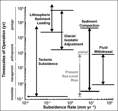
To make matters worse, many coastal areas are sinking even faster than the waters are rising: Natural and human-driven subsidence rates arising from shallow processes can be one to two orders of magnitude greater than the rate of climate-driven sea level rise predicted for the remainder of the 21st century (Figure 1).
The risk of rapid coastal subsidence to infrastructure and economies, as well as to the natural environment in coastal lowlands, is global and is most acute in large river deltas, which are home to about 500 million people.
Thus, we have a pressing need to understand what drives coastal subsidence. We must develop better measurements and modeling, and we must link this science with its socioeconomic implications. In response to this need, an international community of researchers organized a series of workshops—one in New Orleans, La. (2013), and another in Venice, Italy (2016).
As a result of this effort, a working group strategy has emerged that uses key geographic sites to design and test measurement and monitoring methods. Here we report our progress on research in the Mississippi Delta in Louisiana, and we summarize recent efforts to expand this research into other coastal areas. However, the larger goal of the coastal subsidence working group is to initiate global research and monitoring initiatives to address the critical knowledge gaps we must fill to protect coastal populations, infrastructure, and natural resources.
Subsidence Drivers
Human modifications, mainly concentrated in a zone as much as a few hundred meters below the land surface, are responsible for the largest contributions to the subsidence that appears at the ground surface, although other factors contribute as well [Syvitski et al., 2009]. Compaction of high-porosity near-surface sediments often dominates land subsidence [Törnqvist et al., 2008]. The risk is compounded when flood control levees and embankments prevent the deposition of sediment that could compensate for this compaction. Thus, the potential exists for humans to mitigate these types of risks and effects.
Human modifications are responsible for the largest contributions to the subsidence that appears at the ground surface.
Deeper, often poorly understood, processes also contribute to coastal subsidence, including thermal subsidence and fault motion. However, these deeper processes typically contribute less than a few millimeters per year (Figure 1) to the overall loss in elevation in most coastal areas, in contrast to human-caused effects like water withdrawal, which can contribute as much as a meter of subsidence annually.
These deep processes can add to the sum of risk factors, but their contributions are commonly amplified in the deepest deposits of a sedimentary basin because of the response of Earth’s lithosphere to changes in loads (isostatic adjustment), including sediment loading. For example, past ice sheets, like those that once covered large parts of North America and Europe, depressed the Earth’s surface underneath, causing adjacent land masses to rise. Now that these ice sheets have retreated, the surface underneath is gradually rebounding (isostatic adjustment). In response, the surrounding areas now experience annual subsidence rates of as much as 2 millimeters.
Humans also contribute to these deeper processes. Many deltas are major production zones for petroleum and other hydrocarbons, processes that extract fluids from deeper levels, as much as a few kilometers. Extracting these fluids can accelerate subsidence for as long as several decades afterward [Kolker et al., 2011]. Burgeoning coastal lowland demand for groundwater for potable, industrial, and agriculture uses also accelerates subsidence by reducing aquifer fluid pore pressure. A dramatic example can be found in China’s Huanghe Delta, where groundwater removal for coastal aquaculture has produced subsidence hot spots of 250 millimeters annually [Higgins et al., 2013].
Deltas often contain extensive Holocene peat beds that are exposed to oxidation and rapid collapse as shallow aquifers are deflated. In Southeast Asia, deforestation and drainage for agriculture may reduce these peatlands from 90% to 20% intact between 1990 and 2020, resulting in annual subsidence rates of as much as 30–60 millimeters [Hooijer et al., 2012].
Measurements and Monitoring Strategies
Developing subsidence mitigation plans requires a combination of measurement and monitoring strategies. The spatial and temporal changes in elevation associated with subsidence must be measured accurately. Also, the contributions from various driving factors must be separated out, and their respective contributions to the total subsidence rate expressed at the land surface must be quantified.
Measurement strategies must be tailored for individual settings and availability of funds, but any unified, international effort must focus on deltaic areas and coastal megacity “supersites.” These areas are characterized by extreme subsidence rates, and large human populations and supporting infrastructure are at risk.
New Orleans, La., is not a megacity in population, but it is a suitable supersite for concentrating mapping and monitoring of total subsidence because it lies within the subsiding Mississippi Delta. Subsidence in this delta has been identified as a major cause of rapid wetland loss and barrier island degradation, which threatens the viability of the coastal ecosystem [Louisiana Coastal Protection and Restoration Authority (LACPRA), 2012]. This region also experiences subsidence issues related to groundwater extraction and drainage of peat-rich soils [Dixon et al., 2006].
The integrated strategy implemented in metropolitan New Orleans combines a terrestrial network of site-specific measurement stations with remote sensing. We believe that this strategy can be used as a guide for other high-risk coastal cities and deltas.
Our group is addressing the measurement challenge using data from the interferometric synthetic aperture radar (InSAR) instrument aboard NASA Jet Propulsion Laboratory’s Uninhabited Aerial Vehicle Synthetic Aperture Radar (UAVSAR) aircraft to produce spatially continuous total subsidence maps of metropolitan New Orleans [Jones et al., 2016]. This aircraft has gathered L band (1–2 gigahertz) SAR data during semiannual overflights since June 2009. Continuously operating GPS reference stations (CORS) fix these remotely sensed, relative displacement measurements within a global reference frame. Additional CORS stations are being installed at strategic locations in 2016, which will enable more frequent and precise point monitoring of total subsidence.

The second main challenge is to separate out, or deconvolve, the processes that contribute to total subsidence over large urban and deltaic areas. Our strategy is to develop a network of “superstations” in critical, rapidly subsiding areas where multiple subsidence measurement methods can be applied at a single site to examine past and present subsidence. The superstation methodology is motivated by the fact that previous studies, commonly relying on just one method, have often produced conflicting results.
One such superstation, funded by the U.S. Army Corps of Engineers and the first of a planned network, is being installed at a wetland site in the Mississippi Delta. Work began in January 2016, and the superstation is anticipated to be online by the end of the summer of 2016. A continuous sediment drill core extends throughout the Holocene succession into the top of the Pleistocene, enabling us to reconstruct the subsidence history at the site. The superstation is located at a site operated by the Coastwide Reference Monitoring System (CRMS) network, which monitors, among other things, surface elevation change and vertical accretion (deposit accumulation on the delta plain) by means of the rod surface elevation table–marker horizon (RSET-MH) technique [Webb et al., 2013].
Our strategy is to develop a network of “superstations” in critical, rapidly subsiding areas where multiple subsidence measurement methods can be applied at a single site.
The superstation (colocated with the CRMS0276 site) is being equipped with recently developed low-power interferometric optical fiber strainmeters in multiple wells, which are capable of continuous, micrometer-resolution strain monitoring [DeWolf et al., 2013]. Strainmeters will be installed at three depths (about 39, 26, and 10 meters). The deepest of these will penetrate into the Pleistocene basement, allowing us to monitor vertical motions over different depth-integrated strata. GPS antennas will be attached to either the base or top of the strainmeters and tied to the CORS network that is operated by the National Geodetic Survey.
The site will be outfitted with enhanced backscatter hardware, including transponders or corner reflectors [Fujita, 2003; Strozzi et al., 2013] to test various radar reflector designs to optimize use with L band SAR. We will use SAR to derive the regional pattern of total elevation change in deltaic wetland areas, using radar scattering benchmarks as a reference. Subsidence rates can also vary substantially over time, so we anticipate that we will monitor at this and future Mississippi Delta superstations for many years.
Beyond the Mississippi
Team members have allied efforts in other systems, using multiple measurement methodologies to examine the diverse causes of coastal subsidence. For example, in the Ganges-Brahmaputra Delta in Bangladesh, L band InSAR instruments, calibrated with CORS, are measuring land subsidence rates as much as 18 millimeters/year, with the lowest rates appearing primarily in exposed Pleistocene terraces and the highest rates in Holocene organic-rich muds [Higgins et al., 2014].
Although regional subsidence in this delta is primarily controlled by local stratigraphy, with rates varying by more than an order of magnitude depending on lithology, dewatering and tidal sediment exclusion induced by coastal poldering in the 1960s has generated 1–1.5 meters of elevation loss relative to surrounding natural mangrove forest [Auerbach et al., 2015].
In the Venice Lagoon (Italy), a comprehensive monitoring program has been ongoing since 2007, using SAR and an innovative network of more than 50 artificial corner reflectors placed in marshes and tidal flats [Strozzi et al., 2013]. Subsidence rates have declined lagoon-wide since the cessation of groundwater pumping in the 1970s. However, ongoing monitoring with a new generation of SAR satellites (e.g., ALOS PALSAR, COSMOS-SkyMed, Sentinel-1) has recently identified rapid (up to 40 millimeters/year) local subsidence associated with renovation of historical structures and the construction of structures for the Modulo Sperimentale Elettromeccanico (or Experimental Electromechanical Module, MoSE) tidal barrier to protect the lagoon from high-water (acqua alta) events [Tosi et al., 2016]
From Measurements to Modeling
The frontier in subsidence modeling is finding a way to couple individual drivers to provide an integrated simulation of ground motion within a study area that accounts for their interaction. To date, data availability has been a major obstacle in creating such coupled models. Hence, our proposed supersite/superstation network methodology will provide direct observational control on active subsidence drivers in key localities and should be part of an international effort that will also catalog, manage, and disseminate the data to the modeling community.
Predicting future elevation loss in coastal lowlands will ultimately require the use of multiple modeling strategies. Future coupled model advances are necessary to address the complexity induced by multidriver subsidence and interactions between drivers.
Researchers have developed numerical models to simulate a variety of independent subsidence drivers. These include deep natural processes such as isostatic subsidence [Wolstencroft et al., 2014], geomechanical subsidence at the regional scale due to fluid withdrawal [Gambolati and Teatini, 2015], and local-scale processes such as peat oxidation or shallow consolidation caused by surface loading in newly urbanized zones or recently formed deltaic areas [Meckel et al., 2006].
The master plan to restore the Mississippi Delta and adjacent coastal Louisiana is the most expensive restoration plan conceived to date globally.
The world of complex research models that simulate underlying subsidence processes is distinct from the need for simple kinematic, planning-level models of reduced complexity that can be used by policy makers. What we need, in addition to the research models, are simple models that simulate ground motion over time scales (years to decades) and spatial areas (tens to hundreds of square kilometers) that are relevant to decision makers. In order to assess coastal subsidence as part of a larger risk assessment analysis, these models will need to be used in conjunction with other models that predict coastal hazards associated with such phenomena as storm surges, climate-driven sea level rise, and river flooding.
In the Mississippi Delta, where the state of Louisiana’s modeling team is using reduced complexity models to guide project selection and the overall coastal restoration effort, coupling various reduced complexity subsidence models would be a major advance.
Implications for the Mississippi Delta
The master plan to restore the Mississippi Delta and adjacent coastal Louisiana [LACPRA, 2012], the most expensive restoration plan conceived to date globally, presently uses a map, differentiated into 17 geographical regions derived by an expert team, of plausible subsidence rates (0 to 35 millimeters/year). These rates play a much larger role than predicted eustatic sea level rise rates in acreages of wetlands built and preserved and the sustainability of these wetlands over 50-year model simulations for proposed projects [Couvillion et al., 2013].
The integrated program underway by our expert team and others combines satellite and aerial SAR, point ground measurements (CORS, leveling), and subsurface monitoring instrumentation (strainmeters) to better understand the rates and drivers of coastal subsidence. This program will dramatically improve decision makers’ ability to gauge the cost-benefit ratio of individual restoration and protection projects, particularly with regard to their postconstruction evolution.
References
Auerbach, L., S. Goodbred, D. Mondal, C. Wilson, K. R. Ahmed, K. Roy, M. Steckler, J. Gilligan, and B. Ackerly (2015), In the balance: Natural v. embanked landscapes in the Ganges-Brahmaputra tidal delta plain, Nat. Clim. Change, 5, 153–157, doi:10.1038/nclimate2472.
Couvillion, B. R., G. D. Steyer, H. Q. Wang, H. J. Beck, and J. M. Rybczyk (2013), Forecasting the effects of coastal restoration and protection on wetland morphology in coastal Louisiana under multiple environmental uncertainty scenarios, J. Coastal Res., 67, 29–50.
DeWolf, S., S. L. Nooner, M. S. Steckler, M. A. Zumberge, and S. H. Akhter (2013), Optical fiber borehole strainmeter arrays for measuring sediment compaction in Bangladesh, Abstract EP31A-0831 presented at 2013 Fall Meeting, AGU, San Francisco, Calif., 9–13 Dec.
Dixon, T. H., F. Amelung, A. Ferretti, F. Novali, F. Rocca, R. Dokka, G. Sella, S. W. Kim, S. Wdowinski, and D. Whitman (2006), Subsidence and flooding in New Orleans, Nature, 441(7093), 587–588.
Fujita, M. (2003), Development of a retrodirective PARC for ALOS/PALSAR calibration, IEEE Trans. Geosci. Remote Sens., 41, 2177–2186.
Gambolati, G., and P. Teatini (2015), Geomechanics of subsurface water withdrawal and injection, Water Resour. Res., 51, 3922–3955, doi:10.1002/2014WR016841.
Higgins, S., I. Overeem, A. Tanaka, and J. P. M. Syvitski (2013), Land subsidence at aquaculture facilities in the Yellow River Delta, China, Geophys. Res. Lett., 40, 3898–3902, doi:10.1002/grl.50758.
Higgins, S. A., I. Overeem, M. S. Steckler, J. P. M. Syvitski, L. Seeber, and S. H. Akhter (2014), InSAR measurements of compaction and subsidence in the Ganges-Brahmaputra Delta, Bangladesh, J. Geophys. Res. Earth Surf., 119, 1768–1781, doi:10.1002/2014JF003117.
Hooijer, A., S. Page, J. Jauhiainen, W. A. Lee, X. X. Lu, A. Itris, and G. Anshari (2012), Subsidence and carbon loss in drained tropical peatlands, Biogeosciences, 9, 1053–1071.
Jones, C. E., K. An, R. G. Blom, J. D. Kent, E. R. Ivins, and D. Bekaert (2016), Anthropogenic and geologic influences on subsidence in the vicinity of New Orleans, Louisiana, J. Geophys. Res. Solid Earth, 121, 3867–3887, doi:10.1002/2015JB012636.
Kolker, A. S., M. A. Allison, and S. Hameed (2011), An evaluation of subsidence rates and sea-level variability in the northern Gulf of Mexico, Geophys. Res. Lett., 38, L21404, doi:10.1029/2011GL049458.
Louisiana Coastal Protection and Restoration Authority (LACPRA) (2012), Louisiana’s comprehensive master plan for a sustainable coast, 170 pp., Baton Rouge, La.
Meckel, T. A., U. S. Ten Brink, and S. J. Williams (2006), Current subsidence rates due to compaction of Holocene sediments in southern Louisiana, Geophys. Res. Lett., 33, L11403, doi:10.1029/2006GL026300.
Strozzi, T., P. Teatini, L. Tosi, U. Wegmüller, and C. Werner (2013), Land subsidence of natural transitional environments by satellite radar interferometry on artificial reflectors, J. Geophys. Res. Earth Surf., 118, 1177–1191, doi:10.1002/jgrf.20082.
Syvitski, J. P. M., et al. (2009), Sinking deltas due to human activities, Nat. Geosci., 2, 681–686.
Törnqvist, T. E., D. J. Wallace, J. E. A. Storms, J. Wallinga, R. L. Van Dam, M. Blaauw, M. S. Derksen, C. J. W. Klerks, C. Meijneken, and E. M. A. Snijders (2008), Mississippi delta subsidence primarily caused by compaction of Holocene strata, Nat. Geosci., 1, 173–176.
Tosi, L., C. Da Lio, T. Strozzi, and P. Teatini (2016), Combining L- and X-band SAR interferometry to assess ground displacements in heterogeneous coastal environments: The Po River Delta and Venice Lagoon, Italy, Remote Sens., 8(4), 308, doi:10.3390/rs8040308.
Webb, E. L., D. A. Friess, K. W. Krauss, D. R. Cahoon, G. R. Guntenspergen, and J. Phelps (2013), A global standard for monitoring coastal wetland vulnerability to accelerated sea-level rise, Nat. Clim. Change, 3, 458–465.
Wolstencroft, M., Z. Shen, T. E. Törnqvist, G. A. Milne, and M. Kulp (2014), Understanding subsidence in the Mississippi Delta region due to sediment, ice, and ocean loading: Insights from geophysical modeling, J. Geophys. Res. Solid Earth, 119, 3838–3856, doi:10.1002/2013JB010928.
Author Information
Mead Allison and Brendan Yuill, The Water Institute of the Gulf, Baton Rouge, La.; email: meadallison@thewaterinstitute.org; Torbjörn Törnqvist, Tulane University, New Orleans, La.; Falk Amelung, University of Miami, Miami, Fla.; Timothy H. Dixon, University of South Florida, Tampa; Gilles Erkens and Roelof Stuurman, Deltares/Utrecht University, Utrecht, Netherlands; Cathleen Jones, Jet Propulsion Laboratory, California Institute of Technology, Pasadena; Glenn Milne, University of Ottawa, Ottawa, ON, Canada; Michael Steckler, Lamont-Doherty Earth Observatory, Columbia University, Palisades, N.Y.; James Syvitski, Community Surface Dynamics Modeling System, University of Colorado, Boulder; and Pietro Teatini, Dipartimento di Ingegneria Civile Edile e Ambientale, University of Padua, Padua, Italy
Citation:
Allison, M.,Yuill, B.,Törnqvist, T.,Amelung, F.,Dixon, T. H.,Erkens, G.,Stuurman, R.,Jones, C.,Milne, G.,Steckler, M.,Syvitski, J., and Teatini, P. (2016), Global risks and research priorities for coastal subsidence, Eos, 97, https://doi.org/10.1029/2016EO055013. Published on 13 July 2016.
Text © 2016. The authors. CC BY-NC 3.0
Except where otherwise noted, images are subject to copyright. Any reuse without express permission from the copyright owner is prohibited.