Applications of the Google Earth Engine and Phenology-Based Threshold Classification Method for Mapping Forest Cover and Carbon Stock Changes in Siem Reap Province, Cambodia


Abstract
:
1. Introduction
2. Materials and Methods
2.1. Study Area
2.2. Google Earth Engine Remote Sensing Data
2.3. Forest Land Cover Category Threshold Values
2.4. Phenology-based Threshold Classification
- Landsat TM and Landsat OLI TOA collections were accessed using an image collection function in GEE and then a filter function was applied to obtain the collections for a specific season. We used the Siem Reap province area boundary to filter the collections within the study region.
- We used a cloud mask function to minimize the cloud cover on the image to less than 60%, and applied reducer functions to reduce the median values per pixel [50]. The reducer functions decrease the dimensionality of image collections by calculating simple statistics, such as the median value for each pixel. The output reducer median image object (single raster layer) characterizes the quality of the complete image collection.
- We assigned the phenology-based threshold values for individual land cover categories by referring to our previous study [24] and then applied the PBTC function in GEE for the forest land cover classification. The resulting maps were validated using very high-resolution images (VHR) in Google Earth-Pro time-lapse.
- We assessed the forest cover changes from the PBTC maps and calculated the carbon stock changes and emissions by applying equations adapted from Good Practice Guidelines of the Intergovernmental Panel on Climate Change [53] and Sasaki et al. (2016) [10] over the 28-year period. Finally, we established the subnational FREL (using the retrospective approach) up to 2030, an upcoming milestone under the Paris Agreement to which Cambodia is a signatory country.
2.5. Accuracy Assessment and Data for Validation
2.6. Carbon Stocks and Emission Reductions
2.6.1. Estimating the Forest Land Cover Change
2.6.2. Estimation of Total Forest Carbon Stocks
2.6.3. Annual Carbon Emissions Due to Forest Cover Change
2.6.4. Forest Reference Emission Level between 2020 and 2030
2.6.5. Project Emissions
2.6.6. Emission Reductions
2.6.7. Carbon Revenues
3. Results
3.1. PBTC Land Cover Map Accuracy
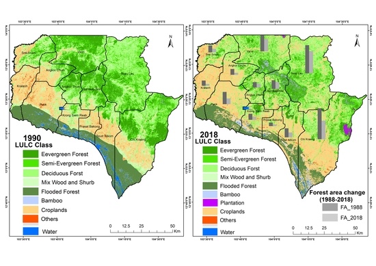
3.2. Siem Reap Forest Cover Change
3.3. Changes in Carbon Stocks by Forest Category
3.4. Forest Cover and Carbon Stock Changes and Carbon Loss
3.5. Carbon Emission, FREL and Emission Reductions
4. Discussions and Implications
5. Conclusions
Supplementary Materials
Supplementary File 1Author Contributions
Funding
Acknowledgments
Conflicts of Interest
Appendix A

| 1990 LULC Categories | WA | OT | CR | Mix WS | DD | SEG | EG | BB | FF | User’s Accuracy (%) |
|---|---|---|---|---|---|---|---|---|---|---|
| WA | 6 | 100 | ||||||||
| OT | 7 | 2 | 7 | 78 | ||||||
| CR | 59 | 100 | ||||||||
| Mix WS | 1 | 45 | 98 | |||||||
| DD | 5 | 88 | 2 | 93 | ||||||
| SEG | 5 | 62 | 7 | 84 | ||||||
| EG | 6 | 59 | 91 | |||||||
| BB | 2 | 3 | 60 | |||||||
| FF | 60 | 100 | ||||||||
| Producer’s accuracy (%) | 100 | 100 | 95 | 90 | 95 | 89 | 87 | 100 | 100 | Total Accuracy 92.84% |
| Kappa 0.91 | ||||||||||
| Total reference points 419 | ||||||||||
| 1995 LULC Category | WA | OT | CR | Mix WS | DD | SEG | EG | BB | FF | User’s Accuracy (%) |
|---|---|---|---|---|---|---|---|---|---|---|
| WA | 9 | 100 | ||||||||
| OT | 4 | 1 | 80 | |||||||
| CR | 4 | 69 | 2 | 92 | ||||||
| Mix WS | 1 | 42 | 3 | 91 | ||||||
| DD | 1 | 98 | 2 | 97 | ||||||
| SEG | 8 | 58 | 1 | 87 | ||||||
| EG | 8 | 48 | 86 | |||||||
| BB | 2 | 100 | ||||||||
| FF | 58 | 100 | ||||||||
| Producer’s accuracy (%) | 100 | 50 | 97 | 93 | 90 | 85 | 98 | 100 | 100 | Total Accuracy 92.60% |
| Kappa 0.91 | ||||||||||
| Total reference points 419 | ||||||||||
| 2000 LULC Category | WA | OT | CR | Mix WS | DD | SEG | EG | BB | FF | User’s Accuracy (%) |
|---|---|---|---|---|---|---|---|---|---|---|
| WA | 9 | 100 | ||||||||
| OT | 2 | 7 | 2 | 64 | ||||||
| CR | 5 | 71 | 3 | 90 | ||||||
| Mix WS | 8 | 37 | 82 | |||||||
| DD | 4 | 99 | 1 | 95 | ||||||
| SEG | 1 | 57 | 2 | 95 | ||||||
| EG | 4 | 46 | 1 | 90 | ||||||
| BB | 2 | 100 | ||||||||
| FF | 58 | 100 | ||||||||
| Producer’s accuracy (%) | 82 | 58 | 88 | 84 | 99 | 92 | 96 | 67 | 100 | Total Accuracy 92.12% |
| Kappa 0.91 | ||||||||||
| Total reference points 419 | ||||||||||
| 2005 LULC Category | WA | OT | CR | Mix WS | DD | SEG | EG | RB | BB | FF | User’s Accuracy (%) |
|---|---|---|---|---|---|---|---|---|---|---|---|
| WA | 10 | 100 | |||||||||
| OT | 3 | 5 | 3 | 45 | |||||||
| CR | 85 | 2 | 98 | ||||||||
| Mix WS | 45 | 3 | 1 | 92 | |||||||
| DD | 5 | 96 | 8 | 88 | |||||||
| SEG | 1 | 56 | 98 | ||||||||
| EG | 3 | 32 | 91 | ||||||||
| RB | - | ||||||||||
| BB | 1 | 3 | 75 | ||||||||
| FF | 57 | 100 | |||||||||
| Producer’s accuracy (%) | 77 | 100 | 97 | 85 | 97 | 82 | 97 | - | 100 | 100 | Total Accuracy 92.84% |
| Kappa 0.91 | |||||||||||
| Total reference points 419 | |||||||||||
| 2010 LULC Category | WA | OT | CR | Mix WS | DD | SEG | EG | RB | BB | FF | User’s Accuracy (%) |
|---|---|---|---|---|---|---|---|---|---|---|---|
| WA | 5 | 100 | |||||||||
| OT | 1 | 14 | 3 | 78 | |||||||
| CR | 1 | 86 | 99 | ||||||||
| Mix WS | 4 | 37 | 3 | 84 | |||||||
| DD | 1 | 6 | 95 | 1 | 92 | ||||||
| SEG | 1 | 59 | 3 | 1 | 92 | ||||||
| EG | 5 | 31 | 1 | 1 | 82 | ||||||
| RB | - | ||||||||||
| BB | 1 | 2 | 67 | ||||||||
| FF | 1 | 56 | 98 | ||||||||
| Producer’s accuracy (%) | 83 | 93 | 91 | 86 | 96 | 91 | 89 | - | 67 | 100 | Total Accuracy 91.89% |
| Kappa 0.90 | |||||||||||
| Total reference points 419 | |||||||||||
| 2015 LULC Category | WA | OT | CR | Mix WS | DD | SEG | EG | RB | BB | FF | User’s Accuracy (%) |
|---|---|---|---|---|---|---|---|---|---|---|---|
| WA | 6 | 100 | |||||||||
| OT | 1 | 11 | 5 | 65 | |||||||
| CR | 2 | 150 | 8 | 94 | |||||||
| Mix WS | 3 | 23 | 2 | 82 | |||||||
| DD | 1 | 7 | 51 | 7 | 77 | ||||||
| SEG | 56 | 1 | 1 | 97 | |||||||
| EG | 2 | 22 | 1 | 88 | |||||||
| RB | 1 | 100 | |||||||||
| BB | 1 | 3 | 1 | 60 | |||||||
| FF | 1 | 52 | 98 | ||||||||
| Producer’s accuracy (%) | 86 | 85 | 94 | 61 | 96 | 86 | 96 | 50 | 60 | 98 | Total Accuracy 89.50% |
| Kappa 0.87 | |||||||||||
| Total reference points 419 | |||||||||||
| 2018 LULC Category | WA | OT | CR | Mix WS | DD | SEG | EG | RB | BB | FF | User’s Accuracy (%) |
|---|---|---|---|---|---|---|---|---|---|---|---|
| WA | 10 | 100 | |||||||||
| OT | 7 | 4 | 64 | ||||||||
| CR | 153 | 6 | 96 | ||||||||
| Mix WS | 3 | 31 | 2 | 86 | |||||||
| DD | 1 | 6 | 51 | 4 | 82 | ||||||
| SEG | 3 | 55 | 1 | 1 | 92 | ||||||
| EG | 2 | 19 | 1 | 86 | |||||||
| RB | 1 | 1 | 50 | ||||||||
| BB | 1 | 3 | 75 | ||||||||
| FF | 2 | 51 | 96 | ||||||||
| Producer’s accuracy (%) | 100 | 100 | 94 | 67 | 96 | 90 | 95 | 50 | 50 | 100 | Total Accuracy 90.93% |
| Kappa 0.88 | |||||||||||
| Total reference points 419 | |||||||||||
| 2000 Ref LULC Category | EG | SE | DD | Mix WS | OF | NF | User’s Accuracy (%) |
|---|---|---|---|---|---|---|---|
| EG | 48 | 4 | 92 | ||||
| SE | 3 | 41 | 1 | 1 | 89 | ||
| DD | 1 | 2 | 54 | 6 | 2 | 1 | 82 |
| Mix WS | 1 | 5 | 36 | 2 | 1 | 80 | |
| OF | 2 | 4 | 8 | 4 | 39 | 3 | 65 |
| NF | 2 | 3 | 6 | 8 | 8 | 123 | 82 |
| Producer’s accuracy (%) | 86 | 75 | 73 | 65 | 76 | 96 | Total Accuracy 81.38% |
| Kappa 0.77 | |||||||
| Total reference points 419 | |||||||
| 2005 Ref LULC Category | EG | SE | DD | Mix WS | OF | NF | User’s Accuracy (%) |
|---|---|---|---|---|---|---|---|
| EG | 39 | 6 | 1 | 1 | 1 | 81 | |
| SE | 2 | 37 | 1 | 1 | 90 | ||
| DD | 2 | 1 | 44 | 5 | 5 | 77 | |
| Mix WS | 1 | 1 | 2 | 21 | 84 | ||
| OF | 2 | 4 | 4 | 1 | 65 | 2 | 83 |
| NF | 5 | 4 | 6 | 7 | 6 | 142 | 84 |
| Producer’s accuracy (%) | 76 | 70 | 76 | 58 | 86 | 98 | Total Accuracy 83.05% |
| Kappa 0.78 | |||||||
| Total reference points 419 | |||||||
| Forest Category | Forest Category Area Cover (ha) | Forest Area Change (ha) | Rate (%) | |||||||
|---|---|---|---|---|---|---|---|---|---|---|
| 1990 | 1995 | 2000 | 2005 | 2010 | 2015 | 2018 | 1990–2018 | Annual Change | ||
| Evergreen Forest | 188,332 | 186,923 | 178,249 | 157,350 | 142,451 | 127,240 | 91,254 | 97,078 | 3467 | −1.8 |
| Semi-Evergreen Forest | 162,797 | 159,084 | 151,325 | 144,430 | 143,221 | 116,251 | 104,529 | 58,268 | 2081 | −1.3 |
| Deciduous Forest | 240,205 | 232,976 | 233,940 | 228,943 | 226,331 | 181,153 | 173,010 | 67,194 | 2400 | −1.0 |
| Mixed Woods and Shrubs | 130,876 | 127,360 | 121,764 | 136,065 | 146,432 | 67,562 | 68,782 | 62,095 | 2218 | −1.7 |
| Flooded Forest | 141,083 | 140,331 | 130,415 | 112,502 | 107,614 | 79,966 | 79,662 | 61,420 | 2194 | −1.6 |
| Bamboo | 6162 | 5600 | 5211 | 7768 | 8364 | 7276 | 8865 | 2703 | 97 | +1.6 |
| Rubber Plantation | 0 | 0 | 0 | 388 | 2677 | 6219 | 20,658 | 20,658 | 738 | +109.0 |
| All forest Area (ha) | 869,455 | 852,274 | 820,904 | 787,447 | 777,091 | 585,667 | 546,760 | 322,694 | 11,525 | −1.3 |
| t | Year | EG (ha) | EG MgC | SEG (ha) | SEG MgC | DD (ha) | DD MgC | MiXWS (ha) | MiXWS MgC | FF (ha) | FF MgC | Total (ha) | Total (MgC) | Loss (MgC) | Emissions/FREL (MgCO2) | PE (t) (MgCO2) | Reduction (MgCO2) | CR (USD Million) |
|---|---|---|---|---|---|---|---|---|---|---|---|---|---|---|---|---|---|---|
| - | 1990 | 209,324 | 34,496,535 | 253,342 | 39,217,345 | 253,342 | 38,026,637 | 151,202 | 5,972,473 | 153,748 | 8,671,386 | 1,020,958 | 126,384,376 | 1,966,196 | 7,209,387 | |||
| 1 | 1991 | 204,546 | 33,709,257 | 250,535 | 38,782,850 | 250,535 | 37,605,335 | 147,916 | 5,842,667 | 150,320 | 8,478,071 | 1,003,853 | 124,418,180 | 1,931,617 | 7,082,595 | |||
| 2 | 1992 | 199,878 | 32,939,945 | 247,759 | 38,353,169 | 247,759 | 37,188,700 | 144,701 | 5,715,684 | 146,969 | 8,289,066 | 987,067 | 122,486,563 | 1,897,710 | 6,958,269 | |||
| 3 | 1993 | 195,317 | 32,188,191 | 245,015 | 37,928,249 | 245,015 | 36,776,680 | 141,556 | 5,591,459 | 143,693 | 8,104,274 | 970,594 | 120,588,854 | 1,864,461 | 6,836,357 | |||
| 4 | 1994 | 190,859 | 31,453,593 | 242,300 | 37,508,036 | 242,300 | 36,369,226 | 138,479 | 5,469,935 | 140,489 | 7,923,601 | 954,428 | 118,724,393 | 1,831,857 | 6,716,810 | |||
| 5 | 1995 | 186,503 | 30,735,761 | 239,615 | 37,092,479 | 239,615 | 35,966,286 | 135,470 | 5,351,052 | 137,357 | 7,746,957 | 938,561 | 116,892,535 | 1,799,885 | 6,599,578 | |||
| 6 | 1996 | 182,247 | 30,034,310 | 236,961 | 36,681,526 | 236,961 | 35,567,810 | 132,525 | 5,234,753 | 134,295 | 7,574,250 | 922,989 | 115,092,650 | 1,768,531 | 6,484,613 | |||
| 7 | 1997 | 178,088 | 29,348,868 | 234,335 | 36,275,126 | 234,335 | 35,173,750 | 129,645 | 5,120,982 | 131,301 | 7,405,394 | 907,705 | 113,324,120 | 1,737,782 | 6,371,868 | |||
| 8 | 1998 | 174,023 | 28,679,070 | 231,739 | 35,873,229 | 231,739 | 34,784,054 | 126,827 | 5,009,683 | 128,374 | 7,240,302 | 892,703 | 111,586,338 | 1,707,626 | 6,261,297 | |||
| 9 | 1999 | 170,052 | 28,024,557 | 229,172 | 35,475,784 | 229,172 | 34,398,677 | 124,071 | 4,900,803 | 125,512 | 7,078,891 | 877,979 | 109,878,711 | 1,678,051 | 6,152,855 | |||
| 10 | 2000 | 166,171 | 27,384,981 | 226,633 | 35,082,742 | 226,633 | 34,017,569 | 121,374 | 4,794,289 | 122,714 | 6,921,078 | 863,525 | 108,200,660 | 1,649,045 | 6,046,498 | |||
| 11 | 2001 | 162,379 | 26,760,002 | 224,122 | 34,694,056 | 224,122 | 33,640,683 | 118,736 | 4,690,091 | 119,978 | 6,766,783 | 849,337 | 106,551,615 | 1,620,595 | 5,942,183 | |||
| 12 | 2002 | 158,673 | 26,149,287 | 221,639 | 34,309,675 | 221,639 | 33,267,973 | 116,156 | 4,588,157 | 117,304 | 6,615,928 | 835,410 | 104,931,020 | 1,592,691 | 5,839,868 | |||
| 13 | 2003 | 155,052 | 25,552,509 | 219,183 | 33,929,553 | 219,183 | 32,899,392 | 113,631 | 4,488,438 | 114,689 | 6,468,436 | 821,738 | 103,338,328 | 1,565,321 | 5,739,511 | |||
| 14 | 2004 | 151,513 | 24,969,350 | 216,755 | 33,553,643 | 216,755 | 32,534,895 | 111,162 | 4,390,887 | 112,132 | 6,324,232 | 808,316 | 101,773,007 | 1,538,474 | 5,641,072 | |||
| 15 | 2005 | 148,055 | 24,399,501 | 214,353 | 33,181,897 | 214,353 | 32,174,436 | 108,746 | 4,295,456 | 109,632 | 6,183,243 | 795,140 | 100,234,533 | 1,512,140 | 5,544,513 | |||
| 16 | 2006 | 144,676 | 23,842,656 | 211,978 | 32,814,270 | 211,978 | 31,817,971 | 106,382 | 4,202,099 | 107,188 | 6,045,397 | 782,203 | 98,722,393 | 1,486,307 | 5,449,793 | |||
| 17 | 2007 | 141,375 | 23,298,520 | 209,630 | 32,450,716 | 209,630 | 31,465,455 | 104,070 | 4,110,771 | 104,798 | 5,910,625 | 769,503 | 97,236,086 | 1,460,966 | 5,356,875 | |||
| 18 | 2008 | 138,148 | 22,766,802 | 207,307 | 32,091,190 | 207,307 | 31,116,845 | 101,808 | 4,021,428 | 102,462 | 5,778,856 | 757,033 | 95,775,120 | 1,436,106 | 5,265,723 | |||
| 19 | 2009 | 134,995 | 22,247,219 | 205,011 | 31,735,647 | 205,011 | 30,772,097 | 99,596 | 3,934,027 | 100,178 | 5,650,026 | 744,790 | 94,339,014 | 1,411,718 | 5,176,299 | |||
| 20 | 2010 | 131,914 | 21,739,494 | 202,739 | 31,384,043 | 202,739 | 30,431,168 | 97,431 | 3,848,525 | 97,944 | 5,524,067 | 732,768 | 92,927,296 | 1,387,792 | 5,088,570 | |||
| 21 | 2011 | 128,904 | 21,243,356 | 200,493 | 31,036,334 | 200,493 | 30,094,017 | 95,313 | 3,764,881 | 95,761 | 5,400,916 | 720,964 | 91,539,504 | 1,364,318 | 5,002,499 | |||
| 22 | 2012 | 125,962 | 20,758,541 | 198,272 | 30,692,478 | 198,272 | 29,760,601 | 93,242 | 3,683,056 | 93,626 | 5,280,511 | 709,374 | 90,175,186 | 1,341,287 | 4,918,053 | |||
| 23 | 2013 | 123,087 | 20,284,790 | 196,075 | 30,352,432 | 196,075 | 29,430,879 | 91,215 | 3,603,009 | 91,539 | 5,162,790 | 697,992 | 88,833,899 | 1,318,691 | 4,835,199 | |||
| 24 | 2014 | 120,278 | 19,821,851 | 193,903 | 30,016,153 | 193,903 | 29,104,810 | 89,233 | 3,524,701 | 89,498 | 5,047,694 | 686,815 | 87,515,209 | 1,296,519 | 4,753,905 | |||
| 25 | 2015 | 117,533 | 19,369,478 | 191,755 | 29,683,599 | 191,755 | 28,782,353 | 87,294 | 3,448,096 | 87,503 | 4,935,163 | 675,839 | 86,218,689 | 1,274,765 | 4,674,138 | |||
| 26 | 2016 | 114,851 | 18,927,428 | 189,630 | 29,354,730 | 189,630 | 28,463,469 | 85,396 | 3,373,155 | 85,552 | 4,825,141 | 665,059 | 84,943,924 | 1,253,418 | 4,595,867 | |||
| 27 | 2017 | 112,230 | 18,495,467 | 187,529 | 29,029,505 | 187,529 | 28,148,118 | 83,540 | 3,299,843 | 83,645 | 4,717,572 | 654,473 | 83,690,506 | 1,232,472 | 4,519,063 | |||
| 28 | 2018 | 109,668 | 18,073,364 | 185,451 | 28,707,883 | 185,451 | 27,836,261 | 81,725 | 3,228,125 | 81,780 | 4,612,401 | 644,076 | 82,458,034 | 1,211,917 | 4,443,694 | |||
| 29 | 2019 | 107,166 | 17,660,894 | 183,397 | 28,389,824 | 183,397 | 27,527,859 | 79,948 | 3,157,965 | 79,957 | 4,509,575 | 633,865 | 81,246,118 | 1,191,745 | 4,369,733 | |||
| 30 | 2020 | 104,720 | 17,257,838 | 181,365 | 28,075,289 | 181,365 | 27,222,874 | 78,211 | 3,089,330 | 78,174 | 4,409,041 | 623,835 | 80,054,372 | 1,171,950 | 4,297,151 | 4,297,151 | - | - |
| 31 | 2021 | 102,330 | 16,863,980 | 179,356 | 27,764,239 | 179,356 | 26,921,268 | 76,511 | 3,022,187 | 76,432 | 4,310,748 | 613,984 | 78,882,422 | 1,152,523 | 4,225,919 | 4,177,059 | 48,860 | 342,021 |
| 32 | 2022 | 99,995 | 16,479,111 | 177,368 | 27,456,635 | 177,368 | 26,623,003 | 74,848 | 2,956,503 | 74,728 | 4,214,647 | 604,307 | 77,729,899 | 1,133,457 | 4,156,010 | 3,999,842 | 156,168 | 1,093,178 |
| 33 | 2023 | 97,713 | 16,103,026 | 175,403 | 27,152,439 | 175,403 | 26,328,043 | 73,221 | 2,892,247 | 73,062 | 4,120,688 | 594,803 | 76,596,442 | 1,114,745 | 4,087,398 | 3,260,374 | 827,024 | 5,789,166 |
| 34 | 2024 | 95,483 | 15,735,523 | 173,460 | 26,851,613 | 173,460 | 26,036,351 | 71,630 | 2,829,387 | 71,433 | 4,028,823 | 585,466 | 75,481,697 | 1,096,379 | 4,020,056 | 3,078,839 | 941,218 | 6,588,525 |
| 35 | 2025 | 93,303 | 15,376,407 | 171,538 | 26,554,120 | 171,538 | 25,747,890 | 70,073 | 2,767,894 | 69,841 | 3,939,007 | 576,294 | 74,385,318 | 1,078,353 | 3,953,960 | 2,891,070 | 1,062,890 | 7,440,227 |
| 36 | 2026 | 91,174 | 15,025,488 | 169,638 | 26,259,923 | 169,638 | 25,462,625 | 68,550 | 2,707,737 | 68,284 | 3,851,193 | 567,283 | 73,306,965 | 1,060,659 | 3,889,083 | 2,832,392 | 1,056,691 | 7,396,837 |
| 37 | 2027 | 89,093 | 14,682,576 | 167,758 | 25,968,985 | 167,758 | 25,180,521 | 67,060 | 2,648,887 | 66,761 | 3,765,336 | 558,432 | 72,246,306 | 1,043,291 | 3,825,401 | 2,774,955 | 1,050,445 | 7,353,118 |
| 38 | 2028 | 87,060 | 14,347,491 | 165,900 | 25,681,271 | 165,900 | 24,901,543 | 65,603 | 2,591,316 | 65,273 | 3,681,394 | 549,735 | 71,203,015 | 1,026,243 | 3,762,890 | 2,718,733 | 1,044,157 | 7,309,098 |
| 39 | 2029 | 85,073 | 14,020,053 | 164,062 | 25,396,745 | 164,062 | 24,625,655 | 64,177 | 2,534,997 | 63,818 | 3,599,323 | 541,191 | 70,176,772 | 1,009,507 | 3,701,527 | 2,663,698 | 1,037,829 | 7,264,800 |
| 40 | 2030 | 83,132 | 13,700,088 | 162,244 | 25,115,370 | 162,244 | 24,352,823 | 62,782 | 2,479,901 | 62,395 | 3,519,081 | 532,797 | 69,167,265 | 993,079 | 3,641,289 | 2,609,824 | 1,031,464 | 7,220,249 |
| Total: Project emissions, Reductions and Carbon credits over a 10-year project from 2020 to 2030 | 35,303,937 | 8,256,746 | 57,797,219 | |||||||||||||||
References
- Hughes, A.C. Understanding the drivers of Southeast Asian biodiversity loss. Ecosphere 2017, 8, e01624. [Google Scholar] [CrossRef]
- Vibol, S.; Towprayoon, S. Estimation of methane and nitrous oxide emissions from rice field with rice straw management in Cambodia. Environ. Monit. Assess. 2010, 161, 301–313. [Google Scholar] [CrossRef]
- Hansen, M.C.; Potapov, P.V.; Moore, R.; Hancher, M.; Turubanova, S.A.; Tyukavina, A.; Thau, D.; Stehman, S.V.; Goetz, S.J.; Loveland, T.R.; et al. High-resolution global maps of 21st-century forest cover change. Science 2013, 342, 850–853. [Google Scholar] [CrossRef] [Green Version]
- Asner, G.P.; Rudel, T.K.; Aide, T.M.; Defries, R.; Emerson, R. A contemporary assessment of change in humid tropical forests. Conserv. Biol. 2009, 23, 1386–1395. [Google Scholar] [CrossRef] [PubMed]
- Blaser, J.; Johnson, S.; Poore, D.; Sarre, A. Status of Tropical Forest Management 2011 Status of Tropical Forest Management; International Tropical Timber Organisation: Jokohama, Japan, 2011. [Google Scholar]
- FAO Global Forest Resources Assessment 2020—Key Findings; FAO: Rome, Italy, 2020; p. 16.
- Le Quéré, C.; Moriarty, R.; Andrew, R.M.; Canadell, J.G.; Sitch, S.; Korsbakken, J.I.; Friedlingstein, P.; Peters, G.P.; Andres, R.J.; Boden, T.A.; et al. Global Carbon Budget 2015. Earth Syst. Sci. Data 2015, 7, 349–396. [Google Scholar] [CrossRef] [Green Version]
- Alexander, S.; Nelson, C.R.; Aronson, J.; Lamb, D.; Cliquet, A.; Erwin, K.L.; Finlayson, C.M.; de Groot, R.S.; Harris, J.A.; Higgs, E.S.; et al. Opportunities and Challenges for Ecological Restoration within REDD+. Restor. Ecol. 2011, 19, 683–689. [Google Scholar] [CrossRef]
- Sasaki, N.; Asner, G.P.; Pan, Y.; Knorr, W.; Durst, P.B.; Ma, H.O.; Abe, I.; Lowe, A.J.; Koh, L.P.; Putz, F.E. Sustainable Management of Tropical Forests Can Reduce Carbon Emissions and Stabilize Timber Production. Front. Environ. Sci. 2016, 4, 50. [Google Scholar] [CrossRef] [Green Version]
- Sasaki, N.; Chheng, K.; Mizoue, N.; Abe, I.; Lowe, A.J. Forest reference emission level and carbon sequestration in Cambodia. Glob. Ecol. Conserv. 2016, 7, 82–96. [Google Scholar] [CrossRef] [Green Version]
- Sasaki, N.; Abe, I.; Khun, V.; Chan, S.; Ninomiya, H.; Chheng, K. Reducing Carbon Emissions through Improved Forest Management in Cambodia. Low Carbon Econ. 2013, 4, 55–67. [Google Scholar] [CrossRef] [Green Version]
- Chave, J.; Andalo, C.; Brown, S.; Cairns, M.A.; Chambers, J.Q.; Eamus, D.; Fölster, H.; Fromard, F.; Higuchi, N.; Kira, T.; et al. Tree allometry and improved estimation of carbon stocks and balance in tropical forests. Oecologia 2005, 145, 87–99. [Google Scholar] [CrossRef]
- Kenzo, T.; Ichie, T.; Hattori, D.; Kendawang, J.J.; Sakurai, K.; Ninomiya, I. Changes in above- and belowground biomass in early successional tropical secondary forests after shifting cultivation in Sarawak, Malaysia. For. Ecol. Manag. 2010, 260, 875–882. [Google Scholar] [CrossRef]
- Gibbs, H.K.; Brown, S.; Niles, J.O.; Foley, J.A. Monitoring and estimating tropical forest carbon stocks: Making REDD a reality. Environ. Res. Lett. 2007, 2, 045023. [Google Scholar] [CrossRef]
- Aronson, J.; Vallejo, R. Monitoring and Evaluating Forest Restoration Success; Springer: New York, NY, USA, 2014. [Google Scholar]
- Chheng, K.; Sasaki, N.; Mizoue, N.; Khorn, S.; Kao, D.; Lowe, A. Assessment of carbon stocks of semi-evergreen forests in Cambodia. Glob. Ecol. Conserv. 2016, 5, 34–47. [Google Scholar] [CrossRef] [Green Version]
- Hemingway, H.J.; Kimsey, M.M. Defining and Estimating Forest Productivity Using Multi-Point Measures and a Nonparametric Approach. For. Sci. 2020. [Google Scholar] [CrossRef]
- Clark, N.A.; Wynne, R.H.; Schmoldt, D.L. A review of past research on dendrometers. For. Sci. 2000, 46, 570–576. [Google Scholar]
- Coppin, P.; Jonckheere, I.; Nackaerts, K.; Muys, B.; Lambin, E. Review ArticleDigital change detection methods in ecosystem monitoring: A review. Int. J. Remote Sens. 2004, 25, 1565–1596. [Google Scholar] [CrossRef]
- Helman, D. Land surface phenology: What do we really ‘see’ from space? Sci. Total Environ. 2018, 618, 665–673. [Google Scholar] [CrossRef]
- Kou, W.; Xiao, X.; Dong, J.; Gan, S.; Zhai, D.; Zhang, G.; Qin, Y.; Li, L. Mapping deciduous rubber plantation areas and stand ages with PALSAR and landsat images. Remote Sens. 2015, 7, 1048–1073. [Google Scholar] [CrossRef] [Green Version]
- Brooks, E.B.; Thomas, V.A.; Wynne, R.H.; Coulston, J.W. Fitting the multitemporal curve: A fourier series approach to the missing data problem in remote sensing analysis. IEEE Trans. Geosci. Remote Sens. 2012, 50, 3340–3353. [Google Scholar] [CrossRef] [Green Version]
- Kiptala, J.K.; Mohamed, Y.; Mul, M.L.; Cheema, M.J.M.; Van Der Zaag, P. Land use and land cover classification using phenological variability from MODIS vegetation in the Upper Pangani River Basin, Eastern Africa. Phys. Chem. Earth 2013, 66, 112–122. [Google Scholar] [CrossRef]
- Venkatappa, M.; Sasaki, N.; Shrestha, R.P.; Tripathi, N.K.; Ma, H.O. Determination of vegetation thresholds for assessing land use and land use changes in Cambodia using the Google Earth Engine cloud-computing platform. Remote Sens. 2019, 11, 1514. [Google Scholar] [CrossRef] [Green Version]
- Adole, T.; Dash, J.; Atkinson, P.M. Characterising the land surface phenology of Africa using 500 m MODIS EVI. Appl. Geogr. 2018, 90, 187–199. [Google Scholar] [CrossRef] [Green Version]
- Langner, A.; Miettinen, J.; Kukkonen, M.; Vancutsem, C.; Simonetti, D.; Vieilledent, G.; Verhegghen, A.; Gallego, J.; Stibig, H.J. Towards operational monitoring of forest canopy disturbance in evergreen rain forests: A test case in continental Southeast Asia. Remote Sens. 2018, 10, 544. [Google Scholar] [CrossRef] [Green Version]
- Schwieder, M.; Leitão, P.J.; Pinto, J.R.R.; Teixeira, A.M.C.; Pedroni, F.; Sanchez, M.; Bustamante, M.M.; Hostert, P. Landsat phenological metrics and their relation to aboveground carbon in the Brazilian Savanna. Carbon Balance Manag. 2018, 13, 7. [Google Scholar] [CrossRef] [PubMed] [Green Version]
- Simonetti, D.; Simonetti, E.; Szantoi, Z.; Lupi, A.; Eva, H.D. First Results from the Phenology-Based Synthesis Classifier Using Landsat 8 Imagery. IEEE Geosci. Remote Sens. Lett. 2015, 12, 1496–1500. [Google Scholar] [CrossRef]
- Tsai, Y.H.; Stow, D.; Chen, H.L.; Lewison, R.; An, L.; Shi, L. Mapping vegetation and land use types in Fanjingshan National Nature Reserve using google earth engine. Remote Sens. 2018, 10, 927. [Google Scholar] [CrossRef] [Green Version]
- Xiong, J.; Thenkabail, P.S.; Tilton, J.C.; Gumma, M.K.; Teluguntla, P.; Oliphant, A.; Congalton, R.G.; Yadav, K.; Gorelick, N. Nominal 30-m cropland extent map of continental Africa by integrating pixel-based and object-based algorithms using Sentinel-2 and Landsat-8 data on google earth engine. Remote Sens. 2017, 9, 1065. [Google Scholar] [CrossRef] [Green Version]
- Li, M.; Zang, S.; Zhang, B.; Li, S.; Wu, C. A Review of Remote Sensing Image Classification Techniques: The Role of Spatio-contextual Information. Eur. J. Remote Sens. 2014, 47, 389–411. [Google Scholar] [CrossRef]
- Xie, Y.; Sha, Z.; Yu, M. Remote sensing imagery in vegetation mapping: A review. J. Plant Ecol. 2008, 1, 9–23. [Google Scholar] [CrossRef]
- Chen, G.; Hay, G.J.; Carvalho, L.M.T.; Wulder, M.A. Object-based change detection. Int. J. Remote Sens. 2012, 33, 4434–4457. [Google Scholar] [CrossRef]
- Lu, D.; Weng, Q. A survey of image classification methods and techniques for improving classification performance. Int. J. Remote Sens. 2007, 28, 823–870. [Google Scholar] [CrossRef]
- Bey, A.; Díaz, A.S.P.; Maniatis, D.; Marchi, G.; Mollicone, D.; Ricci, S.; Bastin, J.-F.F.; Moore, R.; Federici, S.; Rezende, M.; et al. Collect earth: Land use and land cover assessment through augmented visual interpretation. Remote Sens. 2016, 8, 807. [Google Scholar] [CrossRef] [Green Version]
- Romijn, E.; Lantican, C.B.; Herold, M.; Lindquist, E.; Ochieng, R.; Wijaya, A.; Murdiyarso, D.; Verchot, L. Assessing change in national forest monitoring capacities of 99 tropical countries. For. Ecol. Manag. 2015, 352, 109–123. [Google Scholar] [CrossRef] [Green Version]
- Gorelick, N.; Hancher, M.; Dixon, M.; Ilyushchenko, S.; Thau, D.; Moore, R. Google Earth Engine: Planetary-scale geospatial analysis for everyone. Remote Sens. Environ. 2017, 202, 18–27. [Google Scholar] [CrossRef]
- Zhang, M.; Lin, H. Object-based rice mapping using time-series and phenological data. Adv. Sp. Res. 2018, 63, 190–202. [Google Scholar] [CrossRef]
- Fan, H.; Fu, X.; Zhang, Z.; Wu, Q.; Fan, H.; Fu, X.; Zhang, Z.; Wu, Q. Phenology-Based Vegetation Index Differencing for Mapping of Rubber Plantations Using Landsat OLI Data. Remote Sens. 2015, 7, 6041–6058. [Google Scholar] [CrossRef] [Green Version]
- Zhou, Y.; Xiao, X.; Qin, Y.; Dong, J.; Zhang, G.; Kou, W.; Jin, C.; Wang, J.; Li, X. Mapping paddy rice planting area in rice-wetland coexistent areas through analysis of Landsat 8 OLI and MODIS images. Int. J. Appl. Earth Obs. Geoinf. 2016, 46, 1–12. [Google Scholar] [CrossRef] [Green Version]
- Mitchell, A.L.; Rosenqvist, A.; Mora, B. Current remote sensing approaches to monitoring forest degradation in support of countries measurement, reporting and verification (MRV) systems for REDD+. Carbon Balance Manag. 2017, 12, 9. [Google Scholar] [CrossRef] [Green Version]
- Gaughan, A.E.; Binford, M.W.; Southworth, J. Tourism, forest conversion, and land transformations in the Angkor basin, Cambodia. Appl. Geogr. 2009, 29, 212–223. [Google Scholar] [CrossRef]
- MoA Climate Change Priorities Action Plan for Agriculture, Forestry and Fisheries Sector 2016–2020. Available online: http://www.twgaw.org/wp-content/uploads/2016/08/MAFF-CCPAP-2016-2020_final_CLEAN.pdf (accessed on 19 November 2018).
- National Institute of Statistics General Population Census of Cambodia 2019. Available online: https://www.nis.gov.kh/index.php/en/15-gpc/79-press-release-of-the-2019-cambodia-general-population-census (accessed on 26 August 2020).
- TC Cambodia Tourism Statistics–Tourist Information Center | Tourism Cambodia. Available online: https://www.tourismcambodia.com/tourist-information/tourist-statistic.htm (accessed on 29 July 2020).
- Chan, S.; Sasaki, N. Assessment of Drivers of Deforestation and Forest Degradation in Phnom Tbeng Forest Based on Socio-Economic Surveys. J. Environ. Prot. 2014, 5, 1641–1653. [Google Scholar] [CrossRef] [Green Version]
- NIS. National Institute of Statistics. Available online: http://www.nis.gov.kh/index.php/en/ (accessed on 19 August 2020).
- ODC. Open Development Cambodia. Available online: https://opendevelopmentcambodia.net/map-explorer (accessed on 17 August 2020).
- Chander, G.; Markham, B.L.; Helder, D.L. Summary of current radiometric calibration coefficients for Landsat MSS, TM, ETM+, and EO-1 ALI sensors. Remote Sens. Environ. 2009, 113, 893–903. [Google Scholar] [CrossRef]
- Sidhu, N.; Pebesma, E.; Câmara, G. Using Google Earth Engine to detect land cover change: Singapore as a use case. Eur. J. Remote Sens. 2018, 51, 486–500. [Google Scholar] [CrossRef]
- Kou, W.; Liang, C.; Wei, L.; Hernandez, A.; Yang, X. Phenology-Based Method for Mapping Tropical Evergreen Forests by Integrating of MODIS and Landsat Imagery. Forests 2017, 8, 34. [Google Scholar] [CrossRef]
- Jiang, Z.; Huete, A.R.; Didan, K.; Miura, T.; Ramirez-Reyes, C.; Brauman, K.A.; Chaplin-Kramer, R.; Galford, G.L.; Adamo, S.B.; Anderson, C.B.C.; et al. Reimagining the potential of Earth observations for ecosystem service assessments. Remote Sens. Environ. 2019, 112, 3833–3845. [Google Scholar] [CrossRef]
- IPCC. Task Force on National Greenhouse Gas Inventories. Available online: https://www.ipcc-nggip.iges.or.jp/public/2006gl/vol4.html (accessed on 10 June 2020).
- Potere, D. Horizontal positional accuracy of google earth’s high-resolution imagery archive. Sensors 2008, 8, 7973–7981. [Google Scholar] [CrossRef]
- Tilahun, A. Accuracy Assessment of Land Use Land Cover Classification using Google Earth. Am. J. Environ. Prot. 2015, 4, 193. [Google Scholar] [CrossRef]
- Ragheb, A.E.; Ragab, A.F. Enhancement of Google Earth Positional Accuracy. Int. J. Eng. Res. Technol. 2015, 4, 627–630. [Google Scholar]
- Mohammed, N.Z.; Ghazi, A.; Mustafa, H.E. Positional accuracy testing of Google Earth. Int. J. Multidiscip. Sci. Eng. 2013, 4, 6–9. [Google Scholar]
- Olofsson, P.; Foody, G.M.; Herold, M.; Stehman, S.V.; Woodcock, C.E.; Wulder, M.A. Good practices for estimating area and assessing accuracy of land change. Remote Sens. Environ. 2014, 148, 42–57. [Google Scholar] [CrossRef]
- FREL. Initial Forest Reference Level for Cambodia under the UNFCCC Framework. Available online: https://redd.unfccc.int/files/cambodia_frl_rcvd17112016.pdf (accessed on 17 November 2018).
- Denniss, A.T.M.; Lillesand, R.W.; Kiefer, R.W. Remote Sensing and Image Interpretation, 3rd ed.; John Wiley & Sons: New York, NY, USA, 1994; Volume xvi, p. 750. ISBN 0471577839. [Google Scholar] [CrossRef]
- UN-REDD Programme. Technical Considerations for Forest Reference Emission Level and / or Forest Reference Level construction for REDD+ under the UNFCCC; United Nations REDD Programme: Geneva, Switzerland, 2015; ISBN 9789251088418. [Google Scholar]
- Ty, S.; Sasaki, N.; Ahmad, A.H.; Ahmad, Z.A. REDD Development in Cambodia-Potential Carbon Emission Reductions in a REDD Project. Formath 2011, 10, 1–23. [Google Scholar] [CrossRef] [Green Version]
- World Bank; Ecofys. State and Trends of Carbon Pricing 2018 by Word Bank Group; World Bank: Washington, DC, USA, 2018. [Google Scholar]
- Anderson, J.R.; Hardy, E.E.; Roach, J.T.; Witmer, R.E. Land Use and Land Cover Classification System for use With Remote Sensor Data; US Government Printing Office: Washington, DC, USA, 1976.
- John, R.; Jensen, B.Y.U. Introductory Digital Image Processing: A Remote Sensing Perspective, 4th ed.; Prentice Hall Press: New York, NJ, USA, 2015. [Google Scholar]
- MoE Cambodia Forest Cover 2016. Available online: https://redd.unfccc.int/uploads/54_3_cambodia_forest_cover_resource__2016_english.pdf (accessed on 10 June 2020).
- Chim, K.; Tunnicliffe, J.; Shamseldin, A.; Ota, T. Land Use Change Detection and Prediction in Upper Siem Reap River, Cambodia. Hydrology 2019, 6, 64. [Google Scholar] [CrossRef] [Green Version]
- Davis, K.F.; Yu, K.; Rulli, M.C.; Pichdara, L.; D’Odorico, P. Accelerated deforestation driven by large-scale land acquisitions in Cambodia. Nat. Geosci. 2015, 8, 772–775. [Google Scholar] [CrossRef] [Green Version]
- IUCN. Flooded forest fires: A major threat to the Tonle Sap. Available online: https://www.iucn.org/news/cambodia/201607/flooded-forest-fires-major-threat-tonle-sap (accessed on 28 August 2020).
- Sabogal, C.; Besacier, C.; McGuire, D. Forest and landscape restoration: Concepts, approaches and challenges for implementation. Unasylva 2015, 66, 3–10. [Google Scholar]
- Perrin, A. Climate-smart agriculture. Spore 2015, 2015, 18–21. [Google Scholar]
- Tubiello, F.N.; Salvatore, M.; Cóndor Golec, R.D.; Ferrara, A.; Rossi, S.; Biancalani, R.; Federici, S.; Jacobs, H.; Flammini, A. Agriculture, Forestry and Other Land Use Emissions by Sources and Removals by Sinks; FAO: Rome, Italy, 2014; Volume 2. [Google Scholar]
- Tubiello, F.N.; Salvatore, M.; Rossi, S.; Ferrara, A.; Fitton, N.; Smith, P. The FAOSTAT database of greenhouse gas emissions from agriculture. Environ. Res. Lett. 2013, 8, 15009. [Google Scholar] [CrossRef]
- STR. Sustainable travel and the impact of climate change on tourist perceptions | STR. Available online: https://str.com/data-insights-blog/sustainable-travel (accessed on 29 August 2020).
- Nath, A.J.; Das, G.; Das, A.K. Vegetative phenology of three bamboo species in subtropical humid climate of Assam. Trop. Ecol. 2008, 49, 85–89. [Google Scholar]
- Fava, F.; Colombo, R. Remote sensing-based assessment of the 2005–2011 bamboo reproductive event in the arakan mountain range and its relation with wildfires. Remote Sens. 2017, 9, 85. [Google Scholar] [CrossRef] [Green Version]


| Cloud-Free | Path/Raw | Landsat (30 m) | Selected Bands | Number of Image Collections |
|---|---|---|---|---|
| Month and Year | for Median Enhanced Vegetation Index | |||
| December–March | 126/50 | TM-TOA | 4,3,1 | 11 |
| 1989–1990 | 127/51 | |||
| December–March | 126/51 | TM-TOA | 4,3,1 | 21 |
| 1994–1995 | 127/50 | |||
| December–March | 126/51 | TM-TOA | 4,3,1 | 19 |
| 1999–2000 | 167/50 | |||
| December–March | 126 /51 | TM-TOA | 4,3,1 | 19 |
| 2004–2005 | 127/50 | |||
| December–March | 126/51 | TM-TOA | 4,3,1 | 14 |
| 2009–2010 | 127/50 | |||
| December–March | 126/51 | OLI-TOA | 5,4,2 | 20 |
| 2014–2015 | 127/50 | |||
| December–March | 126/51 | OLI-TOA | 5,4,2 | 20 |
| 2017–2018 | 127/50 | |||
| Total | 124 |
| Forest Land Cover Categories in This Study | TM Threshold Values (1990–2010) | OLI Threshold Values (2015–2019) | ||
|---|---|---|---|---|
| Min | Max | Min | Max | |
| Bamboo | 0.671 | 0.776 | 0.854 | 0.882 |
| Plantation (Rubber) | 0.659 | 0.661 | 0.815 | 0.841 |
| Evergreen | 0.515 | 0.659 | 0.652 | 0.769 |
| Semi-Evergreen | 0.435 | 0.501 | 0.581 | 0.648 |
| Deciduous | 0.301 | 0.421 | 0.476 | 0.556 |
| Mixed woods and shrubs | 0.212 | 0.275 | 0.385 | 0.445 |
| Flooded forest | 0.381 | 0.519 | 0.382 | 0.581 |
| IPCC Land Use Category | Forest Land Cover Categories | Initial Carbon Density (MgC/ha) | Total Carbon Stocks | ||||
|---|---|---|---|---|---|---|---|
| Above Ground | Below Ground | Dead Wood | Litter | (MgC/ha) | (MgCO2) | ||
| FOREST | Evergreen Forest | 96.2 | 27.8 | 27.2 | 13.6 | 164.8 | 604.27 |
| Semi-Evergreen | 98.1 | 29.8 | 14.5 | 12.4 | 154.8 | 567.60 | |
| Deciduous Forest | 95.1 | 28.9 | 14.1 | 12 | 150.1 | 550.37 | |
| Bamboo | 36.4 | 11.1 | 5.4 | 4.6 | 57.5 | 210.83 | |
| Flooded Forest | 32.9 | 9.5 | 9.3 | 4.7 | 56.4 | 206.80 | |
| Rubber Plantation | 47 | 13.6 | 13.3 | 6.6 | 80.5 | 295.17 | |
| Wood Shrubland Dry | 20 | 6.1 | 3 | 2.5 | 31.6 | 115.87 | |
| Wood Shrubland Evergreen | 30 | 9.1 | 4.4 | 3.8 | 47.3 | 173.43 | |
| Weighted Average of Total Carbon Stocks | 121.6 | 445.9 | |||||
| Forest Category i | ai | Initial Values of Forest Areai (t0) | R2 |
|---|---|---|---|
| Mix Woods and Shrubs | −0.02 | 151,201.84 | 0.48 |
| Deciduous Forest | −0.01 | 253,342.02 | 0.73 |
| Semi-Evergreen Forest | −0.01 | 253,342.02 | 0.73 |
| Evergreen Forest | −0.01 | 209,323.64 | 0.84 |
| Flooded Forest | −0.02 | 153,747.99 | 0.92 |
| 1990 | 1995 | 2000 | 2005 | 2010 | 2015 | 2018 | ||||||||
|---|---|---|---|---|---|---|---|---|---|---|---|---|---|---|
| Land Cover Categories | UA | PA | UA | PA | UA | PA | UA | PA | UA | PA | UA | PA | UA | PA |
| Water | 100 | 100 | 100 | 100 | 100 | 82 | 100 | 77 | 100 | 83 | 100 | 86 | 100 | 100 |
| Others | 78 | 100 | 80 | 50 | 64 | 58 | 45 | 100 | 78 | 93 | 65 | 85 | 64 | 100 |
| Croplands | 100 | 95 | 92 | 97 | 90 | 88 | 98 | 97 | 99 | 91 | 94 | 94 | 96 | 94 |
| Mixed Woods and Shrubs | 98 | 90 | 91 | 93 | 82 | 84 | 92 | 85 | 84 | 86 | 82 | 61 | 86 | 67 |
| Deciduous Forest | 93 | 95 | 97 | 90 | 95 | 99 | 88 | 97 | 92 | 96 | 77 | 96 | 82 | 96 |
| Evergreen Forest | 84 | 89 | 87 | 85 | 95 | 92 | 98 | 82 | 92 | 91 | 97 | 86 | 92 | 90 |
| Semi-Evergreen Forest | 91 | 87 | 86 | 98 | 90 | 96 | 91 | 97 | 82 | 89 | 88 | 96 | 86 | 95 |
| Rubber Plantation | 100 | 50 | 50 | 50 | ||||||||||
| Bamboo | 60 | 100 | 100 | 100 | 100 | 67 | 75 | 100 | 67 | 67 | 60 | 60 | 75 | 50 |
| Flooded Forest | 100 | 100 | 100 | 100 | 100 | 100 | 100 | 100 | 98 | 100 | 98 | 98 | 96 | 100 |
| Overall Accuracy (%) | 92.84 | 92.6 | 92.12 | 92.84 | 91.89 | 89.5 | 90.93 | |||||||
| Kappa | 0.91 | 0.91 | 0.91 | 0.91 | 0.90 | 0.87 | 0.88 | |||||||
| Land Cover Categories | 2000 | 2005 | ||
|---|---|---|---|---|
| UA | PA | UA | PA | |
| Evergreen Forest | 92 | 86 | 81 | 76 |
| Semi-Evergreen Forest | 89 | 75 | 90 | 70 |
| Deciduous Forest | 82 | 73 | 77 | 76 |
| Mixed Woods and Shrubs | 80 | 65 | 84 | 58 |
| Other Forest | 65 | 76 | 83 | 86 |
| Non-Forest | 82 | 96 | 84 | 98 |
| Overall Accuracy (%) | 81.38 | 83.05 | ||
| Kappa | 0.77 | 0.78 | ||
| Forest Categories | Total Forest Carbon Stocks (MgC) | Change | ||||||
|---|---|---|---|---|---|---|---|---|
| 1990 | 1995 | 2000 | 2005 | 2010 | 2015 | 2018 | 1990–2018 | |
| Evergreen forest | 31,037,040 | 30,804,960 | 29,375,355 | 25,931,242 | 23,475,922 | 20,969,205 | 15,038,590 | −15,998,450 |
| Semi-Evergreen forest | 25,217,307 | 24,642,090 | 23,440,265 | 22,372,222 | 22,184,966 | 18,007,231 | 16,191,616 | −9,025,690 |
| Deciduous forest | 36,030,716 | 34,946,363 | 35,091,036 | 34,341,517 | 33,949,707 | 27,172,999 | 25,951,554 | −10,079,162 |
| Mixed woods and shrubs | 5,163,076 | 5,024,348 | 4,803,599 | 5,367,776 | 5,776,749 | 2,665,304 | 2,713,442 | −2,449,634 |
| Flooded forest | 7,957,072 | 7,914,681 | 7,355,401 | 6,345,094 | 6,069,433 | 4,510,094 | 4,492,959 | −3,464,113 |
| Bamboo | 353,690 | 321,444 | 299,083 | 445,896 | 480,099 | 417,636 | 508,837 | +155,147 |
| Rubber plantation | 0 | 0 | 0 | 0 | 215,479 | 500,590 | 1,662,963 | +1,662,963 |
| Total (MgC) | 105,758,901 | 103,653,886 | 100,364,739 | 94,803,748 | 92,152,354 | 74,243,060 | 66,559,963 | −39,198,938 |
| Forest Area Cover (ha) | Change | Forest Area Loss | ||||||||
|---|---|---|---|---|---|---|---|---|---|---|
| District Name | District Area (ha) | 1990 | 1995 | 2000 | 2005 | 2010 | 2015 | 2018 | 1990–2018 | (% of District Area) |
| Angkor Chum | 47,903 | 34,695 | 32,819 | 30,687 | 29,479 | 28,081 | 17,513 | 16,794 | −17,901 | 37% |
| Angkor Thum | 35,725 | 35,252 | 35,103 | 34,504 | 33,909 | 33,802 | 25,782 | 24,671 | −10,581 | 30% |
| Banteay Srei | 60,070 | 58,117 | 58,031 | 56,208 | 55,100 | 55,487 | 46,050 | 46,099 | −12,018 | 20% |
| Chi Kraeng | 236,236 | 207,124 | 203,086 | 196,058 | 178,956 | 177,110 | 123,162 | 125,576 | −81,548 | 35% |
| Kralanh | 56,807 | 19,060 | 18,632 | 15,225 | 14,492 | 14,359 | 11,114 | 11,323 | −7,737 | 14% |
| Puok | 101,170 | 59,837 | 56,720 | 52,958 | 49,897 | 52,886 | 37,876 | 36,267 | −23,571 | 23% |
| Prasat Bakong | 34,174 | 18,867 | 18,753 | 17,201 | 16,180 | 18,169 | 9,353 | 9,678 | −9,190 | 27% |
| Krong Siem Reab | 47,064 | 39,112 | 35,005 | 30,928 | 28,983 | 31,442 | 19,500 | 21,217 | −17,895 | 38% |
| Soutr Nikom | 77,961 | 60,724 | 59,665 | 55,646 | 50,984 | 48,461 | 29,465 | 33,127 | −27,598 | 35% |
| Srei Snam | 55,757 | 39,659 | 39,535 | 39,182 | 38,693 | 37,655 | 21,500 | 20,293 | −19,366 | 35% |
| Svay Leu | 191,769 | 189,826 | 188,964 | 187,312 | 188,055 | 183,466 | 156,980 | 123,326 | −66,499 | 35% |
| Varin | 109,833 | 107,181 | 105,961 | 104,995 | 102,719 | 96,171 | 87,372 | 78,389 | −28,792 | 26% |
| Total Forest Area (ha) | 869,455 | 852,274 | 820,904 | 787,447 | 777,091 | 585,667 | 546,760 | −322,695 | 31% | |
| Carbon Stock (MgC) | Change (MgC) | Baseline Emissions (MgCO2) | |||||||
|---|---|---|---|---|---|---|---|---|---|
| District Name | 1990 | 1995 | 2000 | 2005 | 2010 | 2015 | 2018 | 1990–2018 | 1990–2018 |
| Angkor Chum | 4,481,724 | 4,211,397 | 3,911,139 | 3,408,585 | 3,251,072 | 2,315,103 | 2,135,163 | −2,346,560 | 8,604,055 |
| Angkor Thum | 4,855,619 | 4,839,508 | 4,771,925 | 4,568,961 | 4,395,144 | 3,615,001 | 3,339,834 | −1,515,785 | 5,557,879 |
| Banteay Srei | 8,262,586 | 8,249,766 | 7,905,274 | 7,303,403 | 7,115,624 | 6,364,061 | 6,184,869 | −2,077,717 | 7,618,294 |
| Chi Kraeng | 24,488,598 | 23,963,522 | 22,949,721 | 20,712,337 | 20,007,740 | 15,403,953 | 15,272,545 | −9,216,053 | 33,792,193 |
| Kralanh | 1,181,106 | 1,124,929 | 947,458 | 865,618 | 853,668 | 714,529 | 777,719 | −403,387 | 1,479,087 |
| Puok | 4,018,699 | 3,612,435 | 3,426,130 | 3,165,192 | 3,316,049 | 2,595,245 | 2,493,081 | −1,525,618 | 5,593,934 |
| Prasat Bakong | 1,315,828 | 1,299,782 | 1,186,309 | 1,092,475 | 1,317,564 | 790,736 | 854,862 | −460,965 | 1,690,207 |
| Krong Siem Reab | 3,370,934 | 2,846,418 | 2,502,309 | 2,366,718 | 2,792,187 | 2,089,725 | 2,244,190 | −1,126,744 | 4,131,395 |
| Soutr Nikom | 5,558,495 | 5,500,495 | 5,246,731 | 4,834,828 | 4,530,883 | 3,004,410 | 3,466,244 | −2,092,251 | 7,671,587 |
| Srei Snam | 4,902,947 | 4,923,917 | 4,817,213 | 4,436,199 | 4,308,653 | 2,783,376 | 2,469,911 | −2,433,036 | 8,921,130 |
| Svay Leu | 27,432,714 | 27,341,797 | 27,124,702 | 27,075,938 | 26,315,551 | 22,401,760 | 16,600,047 | −10,832,667 | 39,719,781 |
| Varin | 15,889,651 | 15,739,920 | 15,575,828 | 14,973,492 | 13,948,221 | 12,165,160 | 10,721,497 | −5,168,154 | 18,949,900 |
| Total (MgC) | 105,758,901 | 103,653,886 | 100,364,739 | 94,803,748 | 92,152,354 | 74,243,060 | 66,559,963 | −39,198,938 | 143,729,440 |
© 2020 by the authors. Licensee MDPI, Basel, Switzerland. This article is an open access article distributed under the terms and conditions of the Creative Commons Attribution (CC BY) license (http://creativecommons.org/licenses/by/4.0/).
Share and Cite
Venkatappa, M.; Sasaki, N.; Anantsuksomsri, S.; Smith, B. Applications of the Google Earth Engine and Phenology-Based Threshold Classification Method for Mapping Forest Cover and Carbon Stock Changes in Siem Reap Province, Cambodia. Remote Sens. 2020, 12, 3110. https://doi.org/10.3390/rs12183110
Venkatappa M, Sasaki N, Anantsuksomsri S, Smith B. Applications of the Google Earth Engine and Phenology-Based Threshold Classification Method for Mapping Forest Cover and Carbon Stock Changes in Siem Reap Province, Cambodia. Remote Sensing. 2020; 12(18):3110. https://doi.org/10.3390/rs12183110
Chicago/Turabian StyleVenkatappa, Manjunatha, Nophea Sasaki, Sutee Anantsuksomsri, and Benjamin Smith. 2020. "Applications of the Google Earth Engine and Phenology-Based Threshold Classification Method for Mapping Forest Cover and Carbon Stock Changes in Siem Reap Province, Cambodia" Remote Sensing 12, no. 18: 3110. https://doi.org/10.3390/rs12183110