Are Wildfires Knocking on the Built-Up Areas Door?
by
 , , , and
Leone D. Mancini
1 ,
,
Mario Elia
2,* ,
,
Anna Barbati
1,
Luca Salvati
3,
Piermaria Corona
3,
Raffaele Lafortezza
2 and
Giovanni Sanesi
2 
1
Department for Innovation in Biological, Agro-Food and Forest Systems (DIBAF), University of Tuscia, Via S. Camillo de Lellis snc, I-01100 Viterbo, Italy
2
Department of Agricultural and Environmental Sciences, University of Bari ‘Aldo Moro’, Via Amendola 165/A, I-70126 Bari, Italy
3
CREA, Research Centre for Forestry and Wood, Viale Santa Margherita 80, I-52100 Arezzo, Italy
*
Author to whom correspondence should be addressed.
Forests 2018, 9(5), 234; https://doi.org/10.3390/f9050234
Submission received: 24 March 2018
/
Revised: 19 April 2018
/
Accepted: 24 April 2018
/
Published: 28 April 2018
(This article belongs to the Special Issue What Role Can Ecological Factors Play in Supporting Ecosystem Services in Urban and Peri-Urban Forests?)
Abstract
:Human-started fires represent the vast majority of wildfires in Mediterranean countries. The current expansion of human settlements into fire-prone territories has led to the creation of landscapes where anthropogenic developments merge with wildland areas. In this context, understanding the role of distance from built-up areas in shaping coarse-scale wildfire spatial patterns is a major concern. Proximity to cities has become an important factor that may increase the probability of wildfires in wildland-urban interfaces. To this issue, we developed an assessment of wildfire distribution in Italy over an 8-year period (2007–2014) to quantify fire occurrence and recurrence as a function of distance from built-up areas. Our findings suggest a positive relationship between the distance from built-up areas and fire incidence (i.e., ratio between burnt forest area and total forest area), whereas a negative relation was found between distance from built-up areas and fire frequency and recurrence; thus, there are more recurring yet smaller sized-fires near built-up areas. Fifty percent of fire events and more than two-thirds of recurrent fires occur within 200 m from built-up areas. On the other hand, the considerable amount of such fire events never reaches an incidence higher than 10% in flat areas and 30% in hilly and mountainous areas. More broadly, quantitative knowledge about where fires occur is essential to ensure appropriate fire management throughout large territories. With this in mind, our investigation intends to provide a solid base for further studies in landscapes with a high component of human-dominated land use.
1. Introduction
Forest fire is an ecological factor in the Mediterranean region that often determines a wide range of impacts on ecosystem services [1]. The capability to understand and predict spatial patterns of forest fire occurrence and recurrence is crucial to improve the effectiveness of fire management resource allocation throughout large territories [2]. This is a remarkably complex research issue due to the multiple biophysical and socioeconomic drivers interacting over different spatial and temporal scales (e.g., [3,4,5]). Changes in wildfire driving forces (e.g., human pressure, climate change) can generate either slow or abrupt modifications in the spatial distribution of forest fires at the regional scale. Assessing and understanding the spatial patterns of wildfires may be a difficult task owing to limitations in fire recording protocols and the complexity of concurrent factors affecting wildfire ignition and spread. However, this knowledge is essential for designing and promoting sustainable land management strategies that incorporate effective measures for fire prevention and suppression [6,7,8].
Earlier studies have investigated the factors affecting wildfire spatial distribution [9]. A high probability of fire occurrence was ascribed to weather (e.g., [10,11]), climate (e.g., [12,13,14]), landscape fuel conditions (e.g., [15,16]), soil moisture (e.g., [17]), ignition agents (e.g., [18,19]), and human pressure (e.g., [20,21]). Large-scale analyses investigating the role of each factor are often partial and not exhaustive. There is a need to develop more comprehensive approaches incorporating the stochastic dimension associated to wildfires and the importance of spatial variability in local environmental conditions and socioeconomic contexts.
Human-induced fires represent the vast majority of wildfires in many regions of the world [22,23,24], particularly in the countries of the Mediterranean region [25,26]. Currently, built-up areas and human pressure into the countryside have not only converted and altered farms and forests but have also produced a mixture of urbanized and rural lands. In addition, the expansion of human settlements into fire-prone landscapes has led to the creation of landscapes where built-up areas merge with wildland areas, namely Wildland-Urban Interfaces (WUIs) [27]. The interplay of biophysical and socioeconomic factors, such as fuel load accumulation, lack of management, proximity to main roads and built-up areas, and seasonal peaks of population density, creates conditions for potential fire ignition and spread. These landscapes, defined as potential forest fire environments, require specific fire protection strategies for defending people, infrastructures, and housing asset values but also to guarantee the provision of ecosystem services [28]. In this context, forest fires can cause remarkable damages to people living in these areas that may be on similar scales to the damages that have recently affected cities like Athens [29], Moscow [30], and Coimbra [31].
Based on these premises, understanding the role of distance from built-up areas in shaping wildfire spatial patterns is becoming a major concern. In the last decade, proximity to cities was considered and studied as an important factor increasing wildfire probability (e.g., [32,33]). Gralewicz et al. [34] identified human proximity and elevation as influential factors of fire susceptibility in Canada. Human impact on fire occurrence and recurrence is primarily a product of population density and road accessibility [34]. Darques [35] considered that the distance to populated places might play a crucial role in determining the growth pattern of wildfires. Based on this evidence, the use of proximity measures to built-up areas in assessing human influence on forest fires has been largely implemented in recent literature [36]. At the same time, elevation is expected to substantially influence fire ignition and spread through fuel moisture and altitudinal zonation of forest vegetation types [37]. All other factors being equal, fuel moisture tends to increase with elevation due to different precipitation levels and temperatures [10,38], while different forest types are characterized by intrinsically different flammability levels [37,39,40].
In the Mediterranean region, various studies have investigated the spatial patterns of wildfires [36,41,42,43,44,45,46,47,48,49,50,51,52,53,54,55,56,57], but none of them have used complete (i.e., all wildfires) spatial datasets (i.e., datasets of mapped wildfire polygons, see Mancini et al. [58]) on a national scale. Further, all these studies did not account for recurrent wildfires despite their key role in driving ecological processes and forest resilience [2,59,60].
In this research, we assessed wildfire distribution in Italy over a period of 8 years (2007–2014) to quantify fire occurrence and recurrence as a function of distance from built-up area in order to provide a solid base for further studies in landscapes with a high component of human-oriented land use.
2. Materials and Methods
2.1. Study Area
Italy is geographically located between 36° and 47°30′ north latitude and 5°30′ and 18°30′ east longitude, extending for 301,330 km2, with 23% of the area classified as lowlands, 42% as uplands, and 35% as mountainous lands. Its complex orography is due to the presence of two main mountain ranges: the Alps in the north and the Apennines in the center-south. In Italy, climate is highly variable following the latitudinal and altitudinal gradients and the distance from the sea, and ranges from Mediterranean warm to temperate cool.
The forested area is approximately 100,000 km2. Overall, 32% of forest formations are included in the Alpine bio-geographical region, 16% in the Continental region, and 52% in the Mediterranean region (sensu the Habitat Directive of the European Commission 43/92). The most widespread forest formations are dominated by various oak species (Quercus spp.) and European beech (Fagus sylvatica L.). A large portion of the broadleaved forests area is managed as coppices [61]. Among conifers, the most widely represented forest types (sensu Barbati et al. [62]) are dominated by Norway spruce (Picea abies (L.) H. Karst.), followed by mountain pines (e.g., Pinus sylvestris L. and P. nigra J.F. Arnold) and Mediterranean pines (P. halepensis Mill., P. pinaster Aiton, and P. pinea L.). Mixed forests (sensu Bravo-Oviedo et al. [63]) are also widespread.
2.2. Forest Fires in Italy
Over the past 20 years, a total of 1,100,000 ha of forest land have been burnt in Italy. An average of 11,000 fires occur annually, burning more than 50,000 ha of forests. The largest wildfires are concentrated in southern Italy and the main islands [64]. In northern Italy, wildfires occur mostly over the first quarter of the year (from January to March), a period when herbaceous vegetation is arid and prone to ignition due to low rainfall and a flow of northern dry winds. Such a condition is especially common in the foothills of the Alps, up to 800 m, and at high elevations in the Apennines. By contrast, in southern Italy the highest probability of wildfire occurrence is essentially in the third quarter of the year (from June to August). Lack of rain and high air temperatures, possibly coupled with strong winds especially at an elevation up to 700 m a.s.l., result in dry fuel conditions that favor fire ignition and spread [40]. Moriondo et al. [65] found that future scenarios of climate change in Italy are expected to produce the highest increase in annual extreme events in all of Mediterranean Europe.
Mancini et al. [58] reported the distribution of fires per fuel types in Italy during the period 2007–2014, when nearly 150,000 hectares of forests were burned. Deciduous oak forests (6843 fires, 44,544 hectares) and broad-leaved evergreen forests (2868 fires, 22,880 hectares) are the most affected forest types both in terms of number of fires and sizes of burned areas, while Mediterranean pine forests are the most affected in relative terms.
2.3. Geospatial Datasets
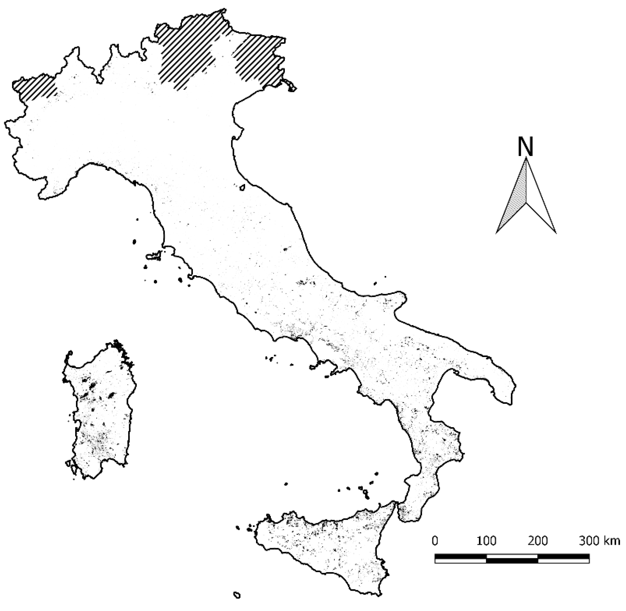
Based on the perimeters of 33,504 forest fires recorded from 2007 to 2014, as provided by the Italian National Forest Service (Corpo Forestale dello Stato, CFS), we compiled an 8-year fire history of Italy (Figure 1). These datasets can have limitations and may contain errors. In different regions of Italy, often the methods of data collection are different, thus generating problems in obtaining reliable and verified data. In order to not fall into errors, we decided to use a time period that is neither too old (considering that we used the forest layer of 2012) nor too recent. For each event, data collection was based on defining the exact geographical position of the ignition point and a field GPS-based delimitation of the burnt area. The database contains all the fires recorded by the CFS, and we assumed the dataset to be complete and reliable, complete with the inclusion of even the smallest fires. The largest recorded size of burnt area was 10,550 ha, while the total burnt area during the study period was nearly 672,037 ha. The most critical situation was recorded in 2007 with over 170,000 hectares burned, while we have the lowest value in 2013 (43,770 hectares).
The forest High Resolution Layer (HRL) [66], including a 20-m resolution raster map of dominant leaf type (20 × 20 m) provided by the Copernicus Land Monitoring Service carried out by the European Earth monitoring program, was used to distinguish forest fires from fires involving other non-urban land-use classes. Forest land was typically characterized using the most updated geospatial dataset (2012) provided by the Corine Land Cover initiative 1:100,000 [67,68]; the 4th hierarchical level of CLC land-use nomenclature system assures a complete mapping of forest types in Italy [69].
We used the Imperviousness Degree HRL [70], 20-m raster dataset, dated 2012 and provided by European Environment Agency, to identify built-up areas, referring to biophysical characteristics, and thus including roads, fabrics, and settlements. The IMD map illustrates the spatial distribution of artificially sealed areas, including the level of soil sealing per area unit [70].
2.4. Data Processing
In order to assess the frequency and incidence of forest fire occurrence and recurrence, we carried out the following analyses: (i) we created the distance raster from the built-up areas (i.e., pixels with imperviousness > 0%); for each fire polygon of the collected geodataset (see section above) we assessed the frequency distribution of fires according to 100-m distance class intervals from built-up areas; (ii) for each forest polygon of the CLC map (CLC class 31) affected by fire, we assessed: the total area of the polygon, the burnt area, and incidence as the ratio between burnt area and the total area of the polygon; we also assessed the mean incidence values for each distance class (100-m interval) from built-up areas; (iii) to assess forest fire recurrence, we selected polygons where fire events occurred at least twice between 2007 and 2014 and recorded the frequency and incidence of recurring fires according to distance class (100-m ramp) from built-up areas. We used a contour plot to investigate the spatial relationships between fire incidence and distance from built-up areas, and also included elevation as a relevant influential factor. As mentioned in the introduction, a contour plot diagram for a function of two variables is a curve connecting points where the function has the same value.
3. Results
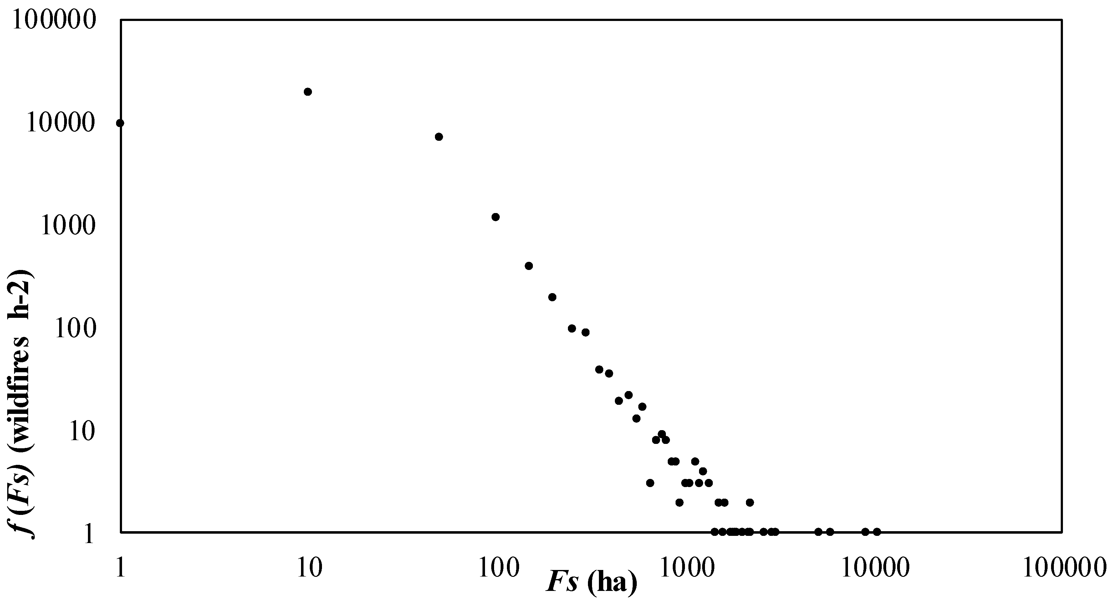
On the whole, although weak, Spearman’s r correlation showed a positive statistical association between distance from built-up areas and both fire incidence (rs = 0.12, p < 0.05), fire recurrence incidence (rs = 0.07, p < 0.05), and average burnt area per event (rs = 0.27, p < 0.05). A negative association between elevation and fire incidence (rs = −0.10, p < 0.05) and fire recurrence (rs = −0.11, p < 0.05) can also be observed too. Fire size distribution in the 2007–2014 time interval was significantly explained by a power-law statistical function over many orders of magnitude, as shown for other case studies (e.g., by Malamud et al. [73] and by Ricotta et al. [74]). Of note, 24,347 events were less than 10 ha in size and only 996 fires extended to more than 100 ha; however, even if these last fires constituted less than 3% of the total fires recorded in Italy, they accounted for 47% of the total area burnt between 2007 and 2014 (Figure 2).
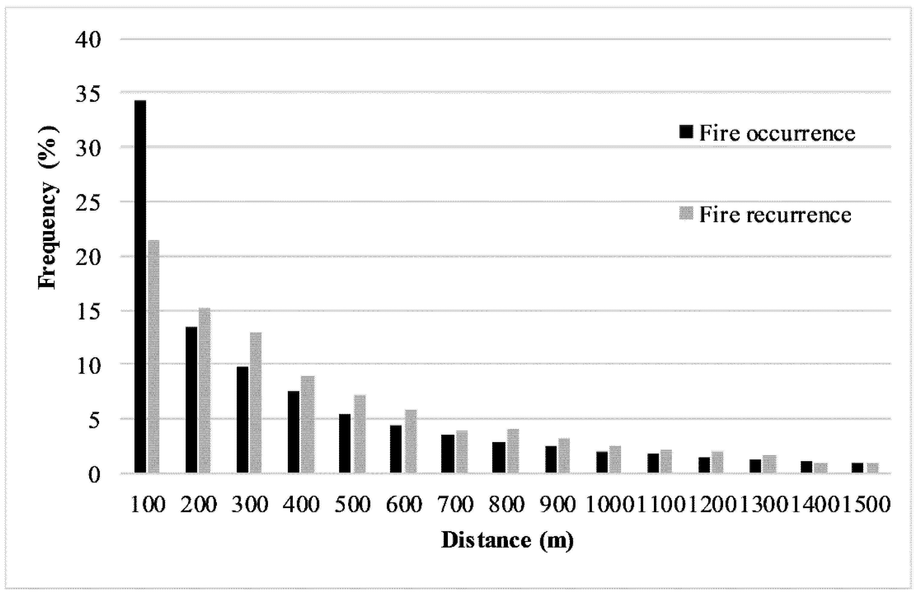
The distribution of forest fires by distance class from built-up areas (Figure 3) showed a similar trend for both occurrence and recurrence of forest fires. The frequency of fire occurrence decreases as the distance from built-up areas increases, for example, from 34% (100 m) to 13% (200 m). Fire recurrence decreased from 21% (100 m) to 15% (200 m). More than 70% of the fire events occurred within 500 m from built-up areas, while more than 70% of the recurring fires were within 600 m from built-up areas.
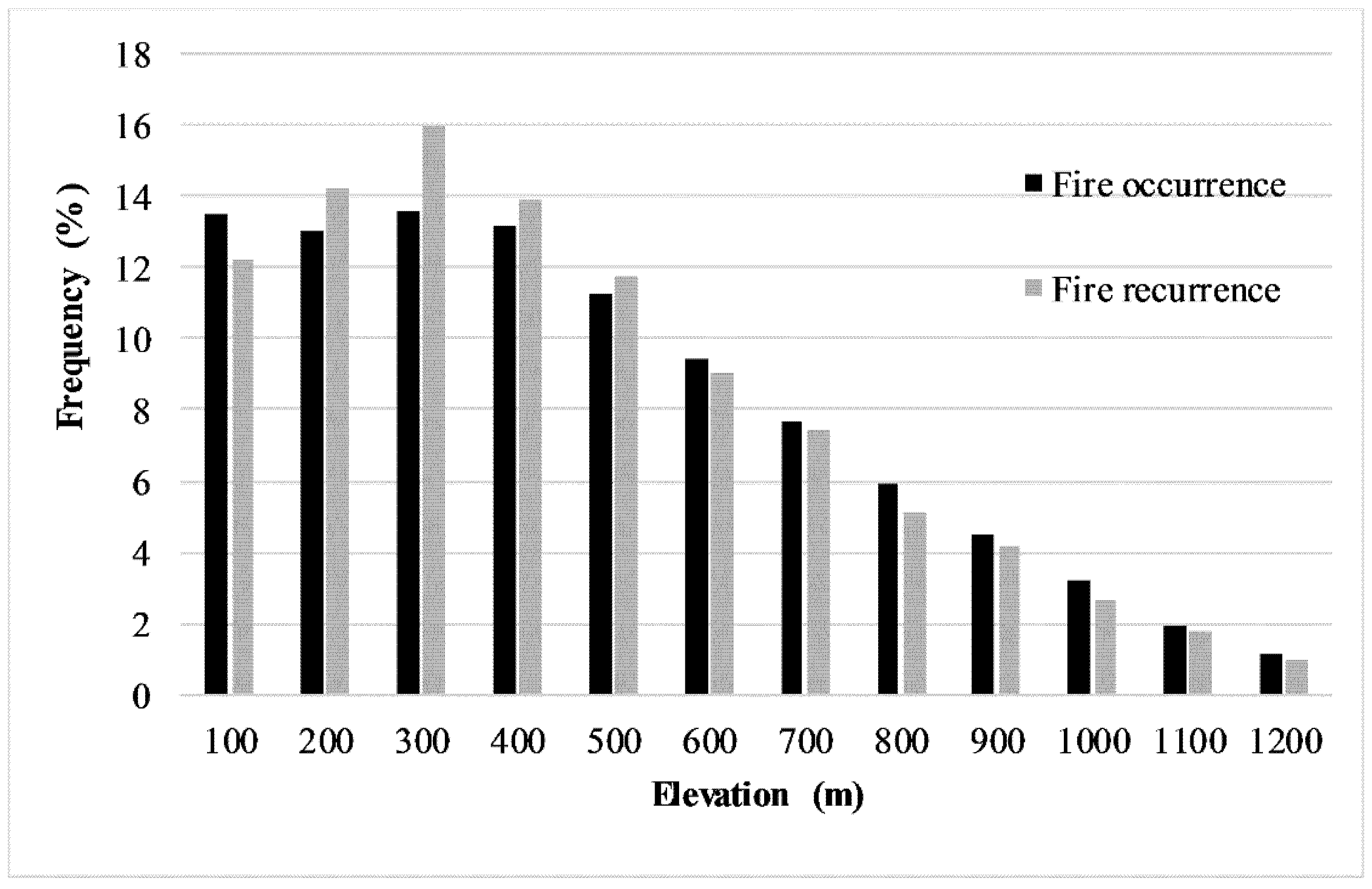
Figure 4 shows the spatial variations in fire frequency by elevation. Fire frequency decreased as elevation increased. Fire occurrence and recurrence were extremely high at elevations up to 400 m a.s.l., and overall, 74% of forest fires and 77% of the recurring fires occurred at elevations below 600 m a.s.l.
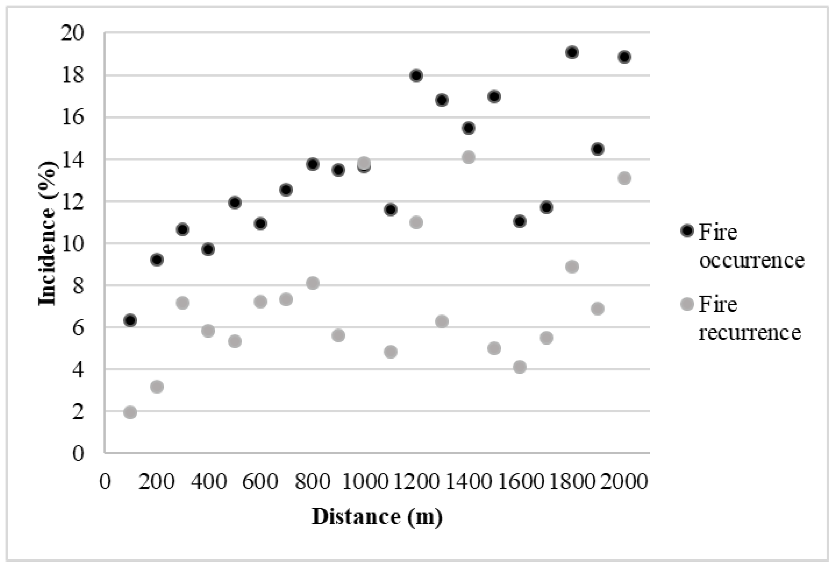
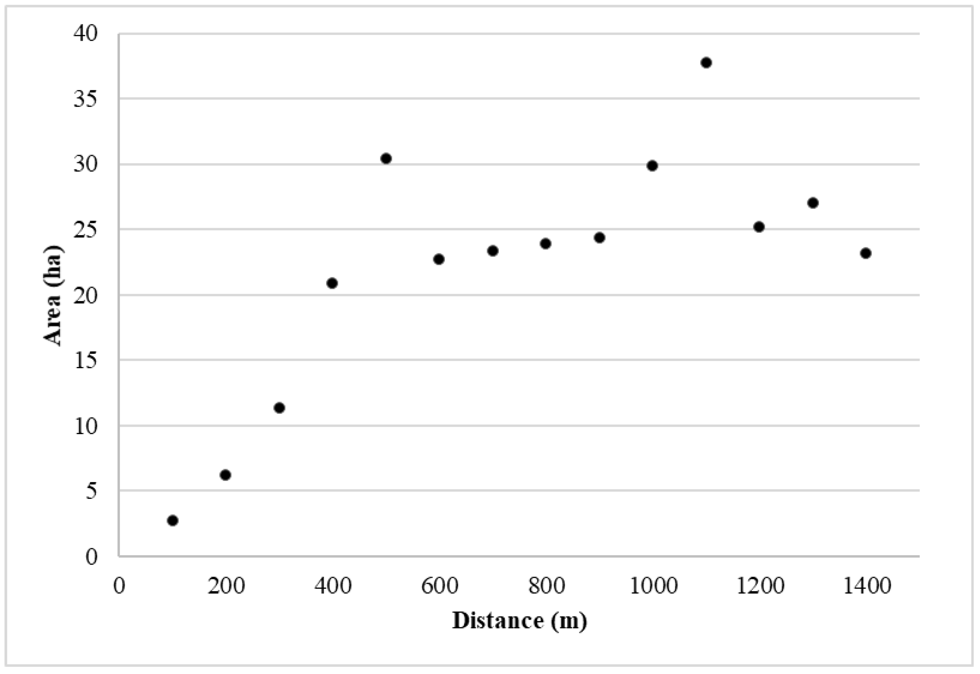
Forest fire incidence showed a more dispersed pattern at increasing distances from built-up areas (Figure 5). However, the highest values of fire incidence (i.e., 15–20% for fire occurrence and 12–14% for fire recurrence) were observed at distances >1000 m; by contrast, the lowest values (i.e., <10% for fire occurrence and <3% for fire recurrence) were found within 200 m from built-up areas. This trend was also reflected by the distribution of average burnt area per event with respect to distance from built-up areas (Figure 6).
The share of forest lands affected by single or repeated burning decreases as elevation increases. Fire incidence ranged between 12% and 15% up to an elevation of <700 m, being systematically lower than 10% at an elevation of >1200 m a.s.l.; fire recurrence reached the highest values in correspondence of the 100, 200, and 300 m a.s.l. elevation classes (13.7%, 9.1%, and 8.5%, respectively) and the lowest values (<2%) above 1200 m a.s.l.
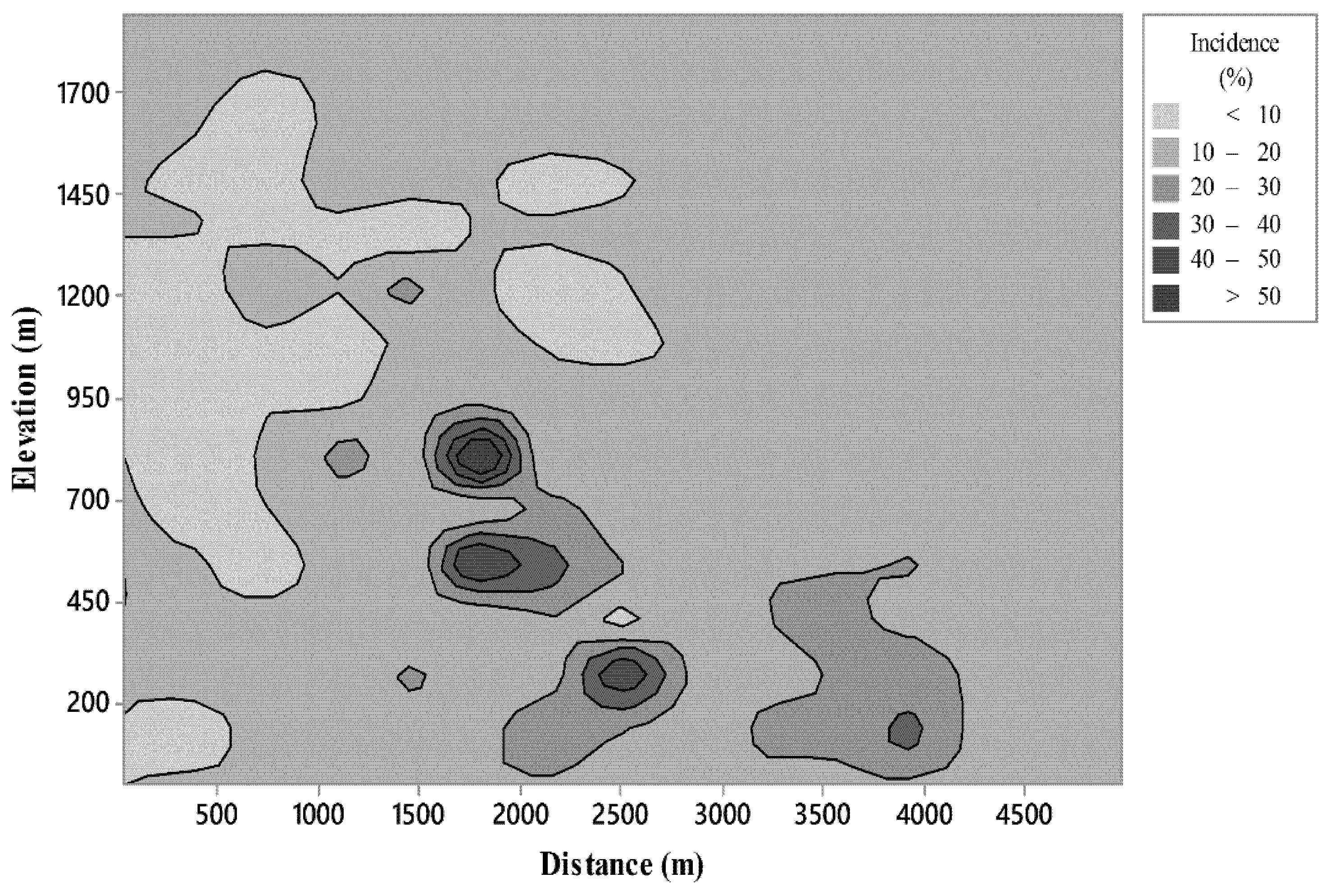
Figure 7 illustrates the values of fire incidence considering both distance from built-up areas and elevation. The contour plot shows areas where forest fire incidence reached maximum values, i.e., at an elevation of approximately 800 m and a distance of 1800 m from built-up areas. We found other critical values for elevations less than 550 m and distances from built-up areas greater than 1800 m.
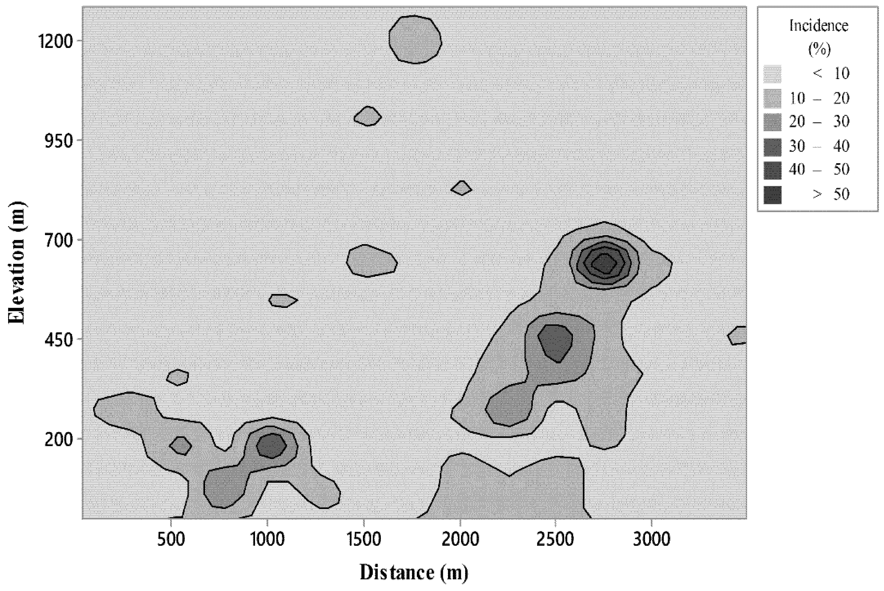
In the case of fire recurrence incidence (Figure 8), the highest values were recorded at an elevation of about 600 m and a distance of 2700 m from built-up areas.
4. Discussion
We analyzed the spatial distribution of forest fires in the Italian peninsula during the 2007–2014 time period. In particular, we investigated two pivotal issues of fire regime: frequency and incidence of forest fires according to relevant territorial predictors such as distance from built-up area and elevation. Notably, distance from built-up areas proved to be one of the most important predictors of wildfire occurrence in landscapes affected by widespread urbanization; this was expected, as in the Mediterranean region the large majority of wildland fires are caused by humans [36,75]. On the other hand, our results indicate that there is a negative relation between distance from built-up areas and fire frequency and recurrence but also a positive relation between the distance from built-up areas and fire incidence: thus, there are more fires, and more recurring events, in closer proximity to built-up areas, but the burnt areas that are closer to built-up areas are usually smaller than what is typically observed in more distant areas.
Our findings, documented on a large (national) scale, are in line with previous local studies affirming that as the distance to roads, urban settlements, and built-up areas increases, fire occurrence decreases (e.g., [36,41,42,45,46,47,48,50,51,52,53,55,56,76]), and fire incidence increases (e.g., [77,54]). In the examined case, nearly 50% of fire occurrence and 36% of recurrent fires occurred within 200 m from built-up areas. Interestingly, a 200-m buffer has been considered to be particularly suitable in the definition of WUIs in Europe [78]: this buffer area should play a key role in the management of prevention activities. Nevertheless, in Italy, such a considerable amount of fires never reached an incidence higher than 10% in flat areas (<200 m) and higher than 30% in hilly and mountainous areas in the considered period.
Territorial zones closer to man-made settlements are thus more likely to burn due to direct human activities and road accessibility (Figure 3). On the other hand, in our national-scale study we found the lowest values of burnt area per event in those zones. This is most likely a result of higher efficiency of fire management in areas where fires may pose significant direct risks to people, infrastructures, and asset values. Proximity to roads may make suppression operations more feasible, and such a proximity is even usually considered a priority zone when managing emergency calls and interventions (e.g., [79,80,81,82]).
Elevation also significantly influences both fire frequency and incidence. Contour plots suggest that elevation and distance from built-up areas represent the most critical combination in terms of fire incidence of single or recurrent fires; these hotspots of fire incidence are located in hilly and low mountain rural areas (1800 to 2700 m from built-up areas, at an elevation between 600 and 800 m).
Quantitative knowledge about where wildfires ignite and spread is essential to ensure appropriate fire management throughout large territories: any rational decision needs to be the outcome of evidence-based considerations [83]. The ability to assess and understand how patterns of wildfires are distributed across large territories helps decision makers to improve the effectiveness of fire prevention, detection, and the allocation of firefighting resources. This issue is particularly crucial for managing fires under the increasing growth of “WUI-scapes”. The use of such a strategy helps in the effective protection of overall ecosystem services [84,85].
5. Conclusions
This study investigated forest fires on a large-scale, covering the entire territory of Italy from both “horizontal” (distance from built-up areas) and “vertical” (elevation) points of view. Once spatial patterns of forest fire occurrence and recurrence across landscapes are identified and analyzed following this approach, fire managers can use this information to answer questions related to fire risk management, especially under extreme weather and fuel conditions. Such questions can range from what type of areas are likely to be treated (and where interventions should occur) to which fuel treatments are most effective for safeguarding people and urban settlements (e.g., [16,86,87]).
The spatial analysis presented here reveals two faces of the same coin: a disproportionately high wildfire occurrence close to built-up areas along with high fire incidence hotspots in quite distant rural areas. The results of this study suggest a greater need for fire management to tackle the complex issue of fire protection in WUIs, for example, the need to optimize the spatial allocation of fire suppression resources to defend people, infrastructures, or asset values. On the other hand, fire protection in rural areas requires the spatial allocation of fire prevention measures, such as prescribed burning and silvicultural tending (e.g., [40]) in order to reduce the size of burned forest areas.
Our findings result from an analysis of wildfires under a dynamic landscape framework and are consequently subject to change as new knowledge is obtained. Nevertheless, this explorative study may be of great practical significance because it not only corroborates prior research, but it also considers a large-scale perspective that will likely impact future analyses in this field. More broadly, the proposed analysis of large-scale spatial patterns of wildfires may apply to other countries (or regions) where time series of geospatial information on forest fire perimeters are available: ultimately, this would allow researchers and policymakers alike to quantitatively address the issue of whether wildfires are knocking on the doors of built-up-areas, and if so, to determine how best to respond.
Author Contributions
Leone D. Mancini and Mario Elia undertook the data processing and analyses, Raffaele Lafortezza and Giovanni Sanesi guided the results interpretation, discussion and conclusion. Anna Barbati, Luca Salvati, Piermaria Corona contributed in data analysis and results interpretation. Mario Elia and Leone D. Mancini authored the first version of the manuscript and all the co-authors improved the version.
Acknowledgments
We fully acknowledge the provision of burned areas geodaset by Italian Forest Service (Corpo Forestale dello Stato), Regional Forest Services of Sardinia (Corpo forestale e di vigilanza ambientale) and Sicilia (Corpo Forestale della Regione Siciliana).
Conflicts of Interest
The authors declare no conflicts of interest.
References
- Harper, A.R.; Doerr, S.H.; Santin, C.; Froyd, C.A.; Sinnadurai, P. Prescribed fire and its impacts on ecosystem services in the UK. Sci. Total Environ. 2018, 624, 691–703. [Google Scholar] [CrossRef] [PubMed]
- Moreira, F.; Viedma, O.; Arianoutsou, M.; Curt, T.; Koutsias, N.; Rigolot, E.; Barbati, A.; Corona, P.; Vaz, P.; Xanthopoulos, G.; et al. Landscape–wildfire interactions in southern Europe, implications for landscape management. J. Environ. Manag. 2011, 92, 2389–2402. [Google Scholar] [CrossRef] [PubMed] [Green Version]
- Senici, D.; Chen, H.Y.; Bergeron, Y.; Cyr, D. Spatiotemporal variations of fire frequency in central boreal forest. Ecosystems 2010, 13, 1227–1238. [Google Scholar] [CrossRef]
- Costa, L.; Thonicke, K.; Poulter, B.; Badeck, F.W. Sensitivity of Portuguese forest fires to climatic; human; and landscape variables, subnational differences between fire drivers in extreme fire years and decadal averages. Reg. Environ. Chang. 2011, 11, 543–551. [Google Scholar] [CrossRef]
- Aldersley, A.; Murray, S.J.; Cornell, S.E. Global and regional analysis of climate and human drivers of wildfire. Sci. Total Environ. 2011, 409, 3472–3481. [Google Scholar] [CrossRef] [PubMed]
- Hann, W.J.; Bunnell, D.L. Fire and land management planning and implementation across multiple scales. Int. J. Wildl. Fire 2001, 10, 389–403. [Google Scholar] [CrossRef]
- Stephens, S.L.; Ruth, L.W. Federal forest-fire policy in the United States. Ecol. Appl. 2005, 15, 532–542. [Google Scholar] [CrossRef]
- Williams, J. Exploring the onset of high-impact mega-fires through a forest land management prism. For. Ecol. Manag. 2013, 294, 4–10. [Google Scholar] [CrossRef]
- Grala, K.; Grala, R.K.; Hussain, A.; Cooke, W.H.; Varner, J.M. Impact of human factors on wildfire occurrence in Mississippi, United States. For. Policy Econ. 2017, 81, 38–47. [Google Scholar] [CrossRef]
- Bessie, W.C.; Johnson, E.A. The relative importance of fuels and weather on fire behavior in subalpine forests. Ecology 1995, 76, 747–762. [Google Scholar] [CrossRef]
- Elia, M.; Lovreglio, R.; Ranieri, N.A.; Sanesi, G.; Lafortezza, R. Cost-Effectiveness of Fuel Removals in Mediterranean Wildland-Urban Interfaces Threatened by Wildfires. Forests 2016, 7, 149. [Google Scholar] [CrossRef]
- Gillett, N.P.; Weaver, A.J.; Zwiers, F.W.; Flannigan, M.D. Detecting the effect of climate change on Canadian forest fires. Geophys. Res. Lett. 2004, 31. [Google Scholar] [CrossRef]
- Mermoz, M.; Kitzberger, T.; Veblen, T.T. Landscape influences on occurrence and spread of wildfires in Patagonian forests and shrublands. Ecology 2005, 86, 2705–2715. [Google Scholar] [CrossRef]
- Pausas, J.G.; Paula, S. Fuel shapes the fire–climate relationship, evidence from Mediterranean ecosystems. Glob. Ecol. Biogeogr. 2012, 21, 1074–1082. [Google Scholar] [CrossRef]
- Romme, W.H. Fire and landscape diversity in subalpine forests of Yellowstone National Park. Ecol. Monogr. 1982, 52, 199–221. [Google Scholar] [CrossRef]
- Elia, M.; Lafortezza, R.; Lovreglio, R.; Sanesi, G. Developing Custom Fire Behavior Fuel Models for Mediterranean Wildland–Urban Interfaces in Southern Italy. Environ. Manag. 2015, 56, 754–764. [Google Scholar] [CrossRef] [PubMed]
- Finney, M.A. Design of regular landscape fuel treatment patterns for modifying fire growth and behavior. For. Sci. 2001, 47, 219–228. [Google Scholar]
- Malamud, B.D.; Millington, J.D.; Perry, G.L. Characterizing wildfire regimes in the United States. Proc. Natl. Acad. Sci. USA 2005, 102, 4694–4699. [Google Scholar] [CrossRef] [PubMed]
- Elia, M.; Lafortezza, R.; Colangelo, G.; Sanesi, G. A streamlined approach for the spatial allocation of fuel removals in wildland–urban interfaces. Landsc. Ecol. 2015, 29, 1771–1784. [Google Scholar] [CrossRef]
- Rollins, M.G.; Swetnam, T.W.; Morgan, P. Evaluating a century of fire patterns in two Rocky Mountain wilderness areas using digital fire atlases. Can. J. For. Res. 2001, 31, 2107–2123. [Google Scholar] [CrossRef]
- Lafortezza, R.; Tanentzap, A.J.; Elia, M.; John, R.; Sanesi, G.; Chen, J. Prioritizing fuel management in urban interfaces threatened by wildfires. Ecol. Indic. 2015, 48, 342–347. [Google Scholar] [CrossRef]
- Goldammer, J.G.; Crutzen, P.J. (Eds.) Fire in the environment, scientific rationale and summary of results of the Dahlem Workshop. In Fire in the Environment, the Ecological; Atmospheric and Climatic Importance of Vegetation Fire; John Wiley and Sons: Toronto, ON, Canada, 1993. [Google Scholar]
- Gill, A.M.; Stephens, S.L.; Cary, G.J. The worldwide “wildfire” problem. Ecol. Appl. 2013, 23, 438–454. [Google Scholar] [CrossRef] [PubMed]
- Moritz, M.A.; Batllori, E.; Bradstock, R.A.; Gill, A.M.; Handmer, J.; Hessburg, P.F.; Leonard, J.; McCaffrey, S.; Odion, D.C.; Schoennagel, T.; et al. Learning to coexist with wildfire. Nature 2014, 515, 58–66. [Google Scholar] [CrossRef] [PubMed]
- Pausas, J.G.; Fernández-Muñoz, S. Fire regime changes in the Western Mediterranean Basin, from fuel-limited to drought-driven fire regime. Clim. Chang. 2012, 110, 215–226. [Google Scholar] [CrossRef] [Green Version]
- San-Miguel-Ayanz, J.; Moreno, J.M.; Camia, A. Analysis of large fires in European Mediterranean landscapes, lessons learned and perspectives. For. Ecol. Manag. 2013, 294, 11–22. [Google Scholar] [CrossRef]
- Theobald, D.M.; Romme, W.H. Expansion of the US wildland–urban interface. Landsc. Urban Plan. 2007, 83, 340–354. [Google Scholar] [CrossRef]
- Galiana-Martin, L.; Herrero, G.; Solana, J. A wildland–urban interface typology for forest fire risk management in Mediterranean areas. Landsc. Res. 2011, 36, 151–171. [Google Scholar] [CrossRef]
- Salvati, L.; Ferrara, A. Do land cover changes shape sensitivity to forest fires in peri-urban areas? Urban For. Urban Green. 2014, 13, 571–575. [Google Scholar] [CrossRef]
- Shaposhnikov, D.; Revich, B.; Bellander, T.; Bedada, G.B.; Bottai, M.; Kharkova, T.; Kvasha, E.; Lezina, E.; Lind, T.; Semutnikova, E.; et al. Mortality related to air pollution with the Moscow heat wave and wildfire of 2010. Epidemiology (Cambridge, Mass.) 2014, 25, 359. [Google Scholar] [CrossRef] [PubMed]
- BBC News Portugal Forest Fires Kill 62 near Coimbra. Available online: http://www.bbc.com/news/world-europe-40316934 (accessed on 19 June 2017).
- Yang, J.; He, H.S.; Shifley, S.R. Spatial controls of occurrence and spread of wildfires in the Missouri Ozark Highlands. Ecol. Appl. 2008, 18, 1212–1225. [Google Scholar] [CrossRef] [PubMed]
- Liu, Z.; Yang, J.; Chang, Y.; Weisberg, P.J.; He, H.S. Spatial patterns and drivers of fire occurrence and its future trend under climate change in a boreal forest of Northeast China. Glob. Chang. Biol. 2012, 18, 2041–2056. [Google Scholar] [CrossRef]
- Gralewicz, N.J.; Nelson, T.A.; Wulder, M.A. Factors influencing national scale wildfire susceptibility in Canada. For. Ecol. Manag. 2012, 265, 20–29. [Google Scholar] [CrossRef]
- Darques, R. Mediterranean cities under fire. A critical approach to the wildland–urban interface. Appl. Geogr. 2015, 59, 10–21. [Google Scholar] [CrossRef]
- Ganteaume, A.; Camia, A.; Jappiot, M.; San-Miguel-Ayanz, J.; Long-Fournel, M.; Lampin, C.A. review of the main driving factors of forest fire ignition over Europe. Environ. Manag. 2013, 51, 651–662. [Google Scholar] [CrossRef] [PubMed]
- Fares, S.; Bajocco, S.; Salvati, L.; Camarretta, N.; Dupuy, J.L.; Xanthopoulos, G.; Guijarro, M.; Madrigal, J.; Hernando, C.; Corona, P. Characterizing potential wildland fire fuel in live vegetation in the Mediterranean region. Ann. For. Sci. 2017, 74, 1. [Google Scholar] [CrossRef]
- Heyerdahl, E.K.; Brubaker, L.B.; Agee, J.K. Spatial controls of historical fire regimes, a multiscale example from the interior west, USA. Ecology 2001, 82, 660–678. [Google Scholar] [CrossRef]
- Xanthopoulos, G.; Calfapietra, C.; Fernandes, P. Fire hazard and flammability of European forest types. In Post-Fire Management and Restoration of Southern European Forests; Moreira, F., Arianoutsou, M., Corona, P., De las Heras, J., Eds.; Springer: Dordrecht, The Netherlands, 2012; pp. 79–92. [Google Scholar]
- Corona, P.; Ascoli, D.; Barbati, A.; Bovio, G.; Colangelo, G.; Elia, M.; Garfì, V.; Iovino, F.; Lafortezza, R.; Leone, V.; et al. Integrated forest management to prevent wildfires under Mediterranean environments. Ann. Silvicult. Res. 2014, 38, 24–45. [Google Scholar]
- De Vasconcelos, M.P.; Silva, S.; Tome, M.; Alvim, M.; Pereira, J.C. Spatial prediction of fire ignition probabilities, comparing logistic regression and neural networks. Photogramm. Eng. Remote Sens. 2001, 67, 73–81. [Google Scholar]
- Kalabokidis, K.D.; Konstantinidis, P.; Vasilakos, C. GIS analysis of physical and human impact on wildfire patterns. In Proceedings of the IV International Conference on Forest Fire Research & Wildland Fire Safety, Coimbra, Portugal, 18–23 November 2002; Millpress: Rotterdam, The Netherlands, 2002. [Google Scholar]
- Koutsias, N.; Allgöwer, B.; Conedera, M. What is common in wildland fire occurrence in Greece and Switzerland?—Statistics to study fire occurrence pattern. In Proceedings of the 4th International Conference on Forest Fire Research, Luso, Portugal, 18–23 November 2002; Viegas, D.X., Ed.; Millpress Science Publishers: Rotterdam, The Netherlands, 2002. [Google Scholar]
- Amatulli, G.; Rodrigues, M.J.; Trombetti, M.; Lovreglio, R. Assessing long-term fire risk at local scale by means of decision tree technique. J. Geophys. Res.-Biogeosci. 2006, 111. [Google Scholar] [CrossRef]
- Badia-Perpinyá, A.; Pallares-Barbera, M. Spatial distribution of ignitions in Mediterranean periurban and rural areas, the case of Catalonia. Int. J. Wildl. Fire 2006, 15, 187–196. [Google Scholar] [CrossRef]
- Lozano, F.J.; Suárez-Seoane, S.; de Luis, E. Assessment of several spectral indices derived from multi-temporal Landsat data for fire occurrence probability modelling. Remote Sens. Environ. 2007, 107, 533–544. [Google Scholar] [CrossRef]
- Lozano, F.J.; Suárez-Seoane, S.; Kelly, M.; Luis, E. A multi-scale approach for modeling fire occurrence probability using satellite data and classification trees. A case study in a mountainous Mediterranean region. Remote Sens. Environ. 2008, 112.3, 708–719. [Google Scholar] [CrossRef]
- Romero-Calcerrada, R.; Novillo, C.J.; Millington, J.D.A.; Gomez-Jimenez, I. GIS analysis of spatial patterns of human-caused wildfire ignition risk in the SW of Madrid (Central Spain). Landsc. Ecol. 2008, 23, 341–354. [Google Scholar] [CrossRef]
- Sebastián-López, A.; Salvador-Civil, R.; Gonzalo-Jiménez, J.; SanMiguel-Ayanz, J. Integration of socio-economic and environmental variables for modelling long-term fire danger in Southern Europe. Eur. J. For. Res. 2008, 127, 149–163. [Google Scholar] [CrossRef]
- Martínez, J.; Vega-Garcia, C.; Chuvieco, E. Human-caused wildfire risk rating for prevention planning in Spain. J. Environ. Manag. 2009, 90, 1241–1252. [Google Scholar] [CrossRef] [PubMed]
- Romero-Calcerrada, R.; Barrio-Parra, F.; Millington, J.D.A.; Novillo, C.J. Spatial modelling of socioeconomic data to understand patterns of human-caused wildfire ignition risk in the SW of Madrid (Central Spain). Ecol. Model. 2010, 221, 34–45. [Google Scholar] [CrossRef]
- Catry, F.X.; Rego, F.C.; Bação, F.L.; Moreira, F. Modeling and mapping wildfire ignition risk in Portugal. Int. J. Wildl. Fire 2010, 18, 921–931. [Google Scholar] [CrossRef]
- Badia, A.; Serra, P.; Modugno, S. Identifying dynamics of fire ignition probabilities in two representative Mediterranean wildland-urban interface areas. Appl. Geogr. 2011, 31, 930–940. [Google Scholar] [CrossRef]
- Moreno, J.M.; Viedma, O.; Zavala, G.; Luna, B. Landscape variables influencing forest fires in central Spain. Int. J. Wildl. Fire 2011, 20, 678–689. [Google Scholar] [CrossRef]
- Oliveira, S.; Oehler, F.; San-Miguel-Ayanz, J.; Camia, A.; Pereira, J.M. Modeling spatial patterns of fire occurrence in Mediterranean Europe using Multiple Regression and Random Forest. For. Ecol. Manag. 2012, 275, 117–129. [Google Scholar] [CrossRef]
- Martínez-Fernández, J.; Chuvieco, E.; Koutsias, N. Modelling long-term fire occurrence factors in Spain by accounting for local variations with geographically weighted regression. Nat. Hazards Earth Syst. 2013, 13, 311–327. [Google Scholar] [CrossRef]
- Rodrigues, M.; de la Riva, J.; Fotheringham, S. Modeling the spatial variation of the explanatory factors of human-caused wildfires in Spain using geographically weighted logistic regression. Appl. Geogr. 2014, 48, 52–63. [Google Scholar] [CrossRef]
- Mancini, L.; Barbati, A.; Corona, P. Geospatial analysis of woodland fire occurrence and recurrence in Italy. Ann. Silvic. Res. 2017, 41, 41–47. [Google Scholar]
- Ricotta, C.; Di Vito, S. Modeling the landscape drivers of fire recurrence in Sardinia. Italy. Environ. Manag. 2014, 53, 1077–1084. [Google Scholar] [CrossRef] [PubMed]
- Barbati, A.; Corona, P.; D’amato, E.; Cartisano, R. Is Landscape a Driver of Short-term Wildfire Recurrence? Landsc. Res. 2015, 40, 99–108. [Google Scholar] [CrossRef] [Green Version]
- Ciancio, O.; Corona, P.; Lamonaca, A.; Portoghesi, L.; Travaglini, D. Conversion of clearcut beech coppices into high forests with continuous cover, A case study in central Italy. For. Ecol. Manag. 2006, 224, 235–240. [Google Scholar] [CrossRef]
- Barbati, A.; Marchetti, M.; Chirici, G.; Corona, P. European forest types and forest Europe SFM indicators, tools for monitoring progress on forest biodiversity conservation. For. Ecol. Manag. 2014, 321, 145–157. [Google Scholar] [CrossRef] [Green Version]
- Bravo-Oviedo, A.; Pretzsch, H.; Ammer, C.; Andenmatten, E.; Antón, C.; Barbati, A.; Barreiro, S.; Brang, P.; Bravo, F.; Brunner, A.; et al. European Mixed Forests, definition and perspectives. For. Syst. 2014, 23, 518–533. [Google Scholar] [CrossRef]
- CFS. Rapporto Annuale Incendi Boschivi [Annual Report on Forest Fires]; Corpo Forestale dello Stato: Rome, Italy, 2016. [Google Scholar]
- Moriondo, M.; Good, P.; Durao, R.; Bindi, M.; Giannakopoulos, C.; Corte-Real, J. Potential impact of climate change on fire risk in the Mediterranean area. Clim. Res. 2006, 31, 85–95. [Google Scholar] [CrossRef]
- FTY HRL Forest Type High Resolution Layer 2012. Available online: http://land.copernicus.eu/pan-european/high-resolution-layers/forests/forest-type/view (accessed on 2 May 2016).
- CLC Corine Land Cover 2012. Available online: http://www.sinanet.isprambiente.it/it/sia-ispra/download-mais/corine-land-cover/corine-land-cover-2012-iv-livello/view (accessed on 2 May 2016).
- EEA CLC 2006 Technical Guidelines. EEA Technical Report No 17/2007. Available online: http://www.eea.europa.eu/publications/technical_report_2007_17 (accessed on 2 May 2016).
- ISPRA. La Realizzazione in Italia del Progetto Corine Land Cover 2006 [The Implementation in Italy of the Project Corine Land Cover 2006]; Report No. 131; Istituto Superiore per la Protezione e la Ricerca Ambientale: Rome, Italy, 2010; p. 49. (In Italian) [Google Scholar]
- IMD HRL Imperviousness Degree High Resolution Layer 2012. Available online: http://land.copernicus.eu/pan-european/high-resolution-layers/imperviousness/imperviousness-2012/view (accessed on 2 May 2016).
- Duvernoy, I.; Zambon, I.; Sateriano, A.; Salvati, L. Pictures from the Other Side of the Fringe: Urban Growth and Peri-urban Agriculture in a Post-industrial City (Toulouse, France). J. Rural Stud. 2018, 57, 25–35. [Google Scholar] [CrossRef]
- Pili, S.; Grigoriadis, E.; Carlucci, M.; Clemente, M.; Salvati, L. Towards Sustainable Growth? A Multi-criteria Assessment of (Changing) Urban Forms. Ecol. Indic. 2017, 76, 71–80. [Google Scholar] [CrossRef]
- Malamud, B.D.; Morein, G.; Turcotte, D.L. Forest fires, an example of self-organized critical behavior. Science 1998, 281, 1840–1842. [Google Scholar] [CrossRef] [PubMed]
- Ricotta, C.; Avena, G.; Marchetti, M. The flaming sandpile, self-organized criticality and wildfires. Ecol. Model. 1999, 119, 73–77. [Google Scholar] [CrossRef]
- Lovreglio, R.; Leone, V.; Giaquinto, P.; Notarnicola, A. Wildfire cause analysis, four case-studies in southern Italy. iForest 2010, 3, 8–15. [Google Scholar] [CrossRef]
- Ganteaume, A.; Long-Fournel, M. Driving factors of fire density can spatially vary at the local scale in south-eastern France. Int. J. Wildl. Fire 2015, 24, 650–664. [Google Scholar] [CrossRef]
- Marques, S.; Borges, J.G.; Garcia-Gonzalo, J.; Moreira, F.; Carreiras, J.M.B.; Oliveira, M.M.; Cantarinha, A.; Botequim, B.; Pereira, J.M.C. Characterization of wildfires in Portugal. Eur. J. For. Res. 2011, 130, 775–784. [Google Scholar] [CrossRef]
- Modugno, S.; Balzter, H.; Cole, B.; Borrelli, P. Mapping regional patterns of large forest fires in Wildland–Urban Interface areas in Europe. J. Environ. Manag. 2016, 172, 112–126. [Google Scholar] [CrossRef] [PubMed]
- Setiawan, I.; Mahmud, A.R.; Mansor, S.; Mohamed Shariff, A.R.; Nuruddin, A. A GIS-grid-based and multi-criteria analysis for identifying and mapping peat swamp forest fire hazard in Pahang, Malaysia. Disaster Prev. Manag. 2004, 13, 379–386. [Google Scholar] [CrossRef] [Green Version]
- Jaiswal, R.K.; Mukherjee, S.; Raju, K.D. Saxena R Forest fire risk zone mapping from satellite imagery and GIS. Int. J. Appl. Earth Obs. Geoinf. 2002, 4, 1–10. [Google Scholar] [CrossRef]
- Kalabokidis, K.D.; Koutsias, N.; Konstantinidis, P.; Vasilakos, C. Multivariate analysis of landscape wildfire dynamics in a Mediterranean ecosystem of Greece. Area 2007, 39, 392–402. [Google Scholar] [CrossRef]
- Mahdavi, A. Forests and rangelands? wildfire risk zoning using GIS and AHP techniques. Casp. J. Environ. Sci. 2012, 10, 43–52. [Google Scholar]
- Corona, P. Consolidating new paradigms in large-scale monitoring and assessment of forest ecosystems. Environ. Res. 2016, 144, 8–14. [Google Scholar] [CrossRef] [PubMed] [Green Version]
- Fernandes, P.M. Fire smart management of forest landscapes in the Mediterranean basin under global change. Landsc. Urban Plan. 2013, 110, 175–182. [Google Scholar] [CrossRef]
- Schroder, S.A.K.; Tóth, S.F.; Deal, R.L.; Ettl, G.J. Multi-objective optimization to evaluate tradeoffs among forest ecosystem services following fire hazard reduction in the Deschutes National Forest, USA. Ecosyst. Serv. 2016, 22, 328–347. [Google Scholar] [CrossRef]
- Kim, Y.H.; Bettinger, P.; Finney, M. Spatial optimization of the pattern of fuel management activities and subsequent effects on simulated wildfires. Eur. J. Oper. Res. 2009, 197, 253–265. [Google Scholar] [CrossRef]
- Corona, P.; Ferrari, B.; Cartisano, R.; Barbati, A. Calibration assessment of forest flammability potential in Italy. iForest 2014, 7, 300. [Google Scholar] [CrossRef]
Figure 1.
Map of the study area with fire perimeters of our dataset. Striped areas have missing values.
Figure 1.
Map of the study area with fire perimeters of our dataset. Striped areas have missing values.

Figure 2.
Normalized frequency-size statistics of forest fires in Italy within the 2007–2014 time interval. The x-axis Fs indicates burnt area and the y-axis ƒ(Fs) represents normalized frequency densities.
Figure 2.
Normalized frequency-size statistics of forest fires in Italy within the 2007–2014 time interval. The x-axis Fs indicates burnt area and the y-axis ƒ(Fs) represents normalized frequency densities.

Figure 3.
Relative frequency of forest fire events according to distance class from the built-up areas.
Figure 3.
Relative frequency of forest fire events according to distance class from the built-up areas.

Figure 4.
Relative frequency of forest fire events by elevation class.

Figure 5.
Mean values of fire incidence according to distance class from the built-up areas.

Figure 6.
Mean values of burnt area per event according to distance class from the built-up areas.

Figure 7.
Contour plot diagram where fire incidence is shown as a function of elevation and distance from built-up areas.
Figure 7.
Contour plot diagram where fire incidence is shown as a function of elevation and distance from built-up areas.

Figure 8.
Contour plot diagram where fire recurrence incidence is shown as a function of elevation and distance from built-up areas.
Figure 8.
Contour plot diagram where fire recurrence incidence is shown as a function of elevation and distance from built-up areas.

© 2018 by the authors. Licensee MDPI, Basel, Switzerland. This article is an open access article distributed under the terms and conditions of the Creative Commons Attribution (CC BY) license (http://creativecommons.org/licenses/by/4.0/).
Share and Cite
MDPI and ACS Style
Mancini, L.D.; Elia, M.; Barbati, A.; Salvati, L.; Corona, P.; Lafortezza, R.; Sanesi, G. Are Wildfires Knocking on the Built-Up Areas Door? Forests 2018, 9, 234. https://doi.org/10.3390/f9050234
AMA Style
Mancini LD, Elia M, Barbati A, Salvati L, Corona P, Lafortezza R, Sanesi G. Are Wildfires Knocking on the Built-Up Areas Door? Forests. 2018; 9(5):234. https://doi.org/10.3390/f9050234
Chicago/Turabian StyleMancini, Leone D., Mario Elia, Anna Barbati, Luca Salvati, Piermaria Corona, Raffaele Lafortezza, and Giovanni Sanesi. 2018. "Are Wildfires Knocking on the Built-Up Areas Door?" Forests 9, no. 5: 234. https://doi.org/10.3390/f9050234
Note that from the first issue of 2016, this journal uses article numbers instead of page numbers. See further details here.