Article

Opening up Smart Cities: Citizen-Centric Challenges and Opportunities from GIScience

1
Institute for Geoinformatics, University of Muenster, Heisenbergstrasse 2, 48161 Muenster, Germany
2
Institute of New Imaging Technologies, Universitat Jaume I, Av. Vicente Sos Baynat s/n, 12071 Castellón de la Plana, Spain
3
NOVA IMS Information Management School, University Nova Lisboa, 1070-312 Lisbon, Portugal
*
Author to whom correspondence should be addressed.
ISPRS Int. J. Geo-Inf. 2016, 5(2), 16; https://doi.org/10.3390/ijgi5020016
Submission received: 13 November 2015 / Revised: 29 January 2016 / Accepted: 3 February 2016 / Published: 17 February 2016
(This article belongs to the Special Issue Geo-Information Fostering Innovative Solutions for Smart Cities)

Abstract

:
The holy grail of smart cities is an integrated, sustainable approach to improve the efficiency of the city’s operations and the quality of life of citizens. At the heart of this vision is the citizen, who is the primary beneficiary of smart city initiatives, either directly or indirectly. Despite the recent surge of research and smart cities initiatives in practice, there are still a number of challenges to overcome in realizing this vision. This position paper points out six citizen-related challenges: the engagement of citizens, the improvement of citizens’ data literacy, the pairing of quantitative and qualitative data, the need for open standards, the development of personal services, and the development of persuasive interfaces. The article furthermore advocates the use of methods and techniques from GIScience to tackle these challenges, and presents the concept of an Open City Toolkit as a way of transferring insights and solutions from GIScience to smart cities.

1. Introduction

It is widely recognised that the concept of smart cities is still emerging, and different stakeholders have distinct conceptualizations about what a smart city is or should be. When considering recent smart cities projects, it is obvious that they deal with distinct facets of cities, and that they have disparate objectives and implementation strategies. Some are driven by companies to promote (proprietary) technology- and sensor-intensive cities (e.g., IBM Smarter Cities [1], Microsoft CityNext [2], while others are run by consortia of universities, companies and city councils and take a collaborative approach to build smart cities (e.g., MK:Smart [3], CitySDK [4]). In this paper, we adopt the definition by Yin et al. [5]: “a smart city is a system integration of technological infrastructure that relies on advanced data processing with the goals of making city governance more efficient, citizens happier, businesses more prosperous and the environment more sustainable”. This definition emphasizes the role of citizens as main beneficiaries (as in, e.g., [6]), and places data and advanced data processing (as in, e.g., [7]) at the center. Similar to [8,9,10], this article furthermore builds upon the assumption that open data may yield substantial benefits to (smart) cities. We indeed believe that “opening up cities”, i.e., empowering citizens to take full advantage of available open data, is a promising way to foster innovation, creativity, and citizens-centric solutions for smart cities. In addition, we argue that geographic data and Geographic Information Science (GIScience) may play an important role in shaping smart cities.
With the proliferation of smart city initiatives, the risk of duplicating efforts and re-inventing the wheel increases. To mitigate this risk, there is a need to get a complete picture of what different research fields can offer to tackle smart city challenges. Comprehensively exposing the achievements of different disciplines allows us to identify those areas that can fruitfully collaborate to realize the smart city vision. This article is written with this viewpoint in mind, and articulates what GIScience has achieved and can offer to smart cities. By matching smart city challenges and GIScience achievements we demonstrate that GIScience is essential in addressing citizen-centric challenges in a smart city context. Consequently, our contribution is threefold:
  • a synthesis of citizen-centric challenges in the smart city context;
  • a collection of relevant key contributions of and opportunities from GIScience to help address the identified challenges;
  • a citizen-centric, technology-driven approach to address these challenges (the Open City Toolkit).
In the following sections, we first discuss related work on smart and open cities (Section 2). Section 3 concisely summarizes key citizen-centric challenges. The opportunities offered by GIScience to address the challenges are introduced in Section 4. Section 5 presents the Open City Toolkit as an approach to realize these opportunities, and outlines core research directions currently explored within the GEO-C project. Section 6 summarizes the main contributions of this article.

2. Related Work on Smart and Open Cities

Due to the inherent complexity of smart cities, previous work has produced distinct but complementary perspectives on identifying problems, challenges and trends for the effective conceptualization and implementation of smart cities. This section briefly reviews existing literature on smart and open cities, and sets the scene for identifying key challenges and opportunities in the following section(s).

2.1. Trends in Technologies, Architectures, and Infrastructures for Smart Cities

Yin et al. [5] conducted an exhaustive literature survey of smart cities, which touched upon a number of dimensions or perspectives including application domain, technological infrastructure, system integration and data processing. The authors concluded that some researchers have defined smart cities from multiple perspectives (e.g. [6]), while others have given a definition covering only one of the four perspectives. In the literature [5,11,12] many application areas have been discussed such as government (increasing efficiency and transparency through open data, citizen services, smart city platform, heritage monitoring), citizens (increasing happiness, participation and education) and economy (increasing revenues via social wifi, e-commerce, tourism management, mobile marketing, outdoor digital marketing). Further areas include environment (increasing sustainability by providing solutions for energy efficiency), mobility (improving parking, public transit, or traffic management) and public service utilities such as water and waste (increasing efficiency).
A combined physical and digital infrastructure is considered central to shape smarter solutions for application domains such as the ones listed above. For digital infrastructures, Information and Communication Technology (ICT) and Internet technologies can be regarded as a means to integrate and coordinate city subsystems in order to make cities smarter, more livable and more sustainable [13,14]. Yin et al. [5] proposed a technological architecture along those lines, which is composed of four layers: a data acquisition layer, a data vitalization layer, a common data and service layer, and a domain application layer. Data has a prominent role here, which reflects the authors’ view that “[f]rom the perspective of computers and information systems, the city is defined by its sensed data”. Nevertheless, the authors also recognize the tension between accuracy and computational costs of models, i.e. accurate models are desirable, but they are also computationally expensive. A second challenging task in smart cities they identified is the re-use of existing datasets for purposes different from the ones they were originally collected for.
An alternative perspective on smart city architectures is proposed by da Silva et al. [15]. The authors analyzed 17 technical architectures from literature, and extracted a set of challenges, mostly technical and data-driven, that smart city architectures should address: objects interoperability, sustainability, real-time monitoring, historical data, mobility, availability, privacy, distributed sensing and processing, service composition and integrated urban management, the incorporation of social aspects, and flexibility/extensibility.
In addition to digital infrastructures, physical infrastructures are also vital to realize smart cities. More specifically, the Internet of Things (IoT) can be regarded as a critical enabler of smart cities infrastructures [16]. Zanella et al. [17] discussed implementation strategies for urban systems leveraging the inherent characteristics of IoT to connect and integrate “a large number of different and heterogeneous end systems, while providing open access to selected subsets of data for the development of a plethora of digital services”. [18] defines a social layer, which can potentially horizontally connect several application domains, on top of the IoT to simplify the management of huge volumes of objects. [19] proposes a similar concept, the so-called “Social Internet of Things” paradigm, in which things borrow the concepts of cooperation and social relationships for the establishment and management of social relationships between smart objects or things. As Chen et al. [20] point out, the widespread deployment of IoT drives the high growth of data both in quantity and diversity, which results in big data. Similarly, the application of big data technology to IoT accelerates research in this area and facilitates the development of new business models for IoT.

2.2. Beyond Technologies, Architectures, and Infrastructures

Challenges in smart cities can be explored from other viewpoints than digital and physical infrastructures. For example, Nam and Pardo [6] argue that technological innovation is a means to a smart city, not an end. Branchi et al. [21] also highlight that smart cities are not only about technologies applied to the city and its spaces. They should also take into account the impact technologies have on the inhabitants of cities. For this purpose, Branchi et al. proposed the Technologies Analysis Matrix (TAM), which can be used to assign scores to technology-related aspects (e.g., usefulness, advantages/disadvantages, risks/benefits), with respect to impact dimensions (e.g., environmental sustainability, economic sustainability and social sustainability). In addition, the authors proposed the Smart City Matrix (SCM) as a tool to assess how a combination of technologies performs on the mobility, energy, and quality of life in a city.
Rather than focussing on technology alone, there is a growing recognition that designing and deploying citizen-centric city services greatly improves the smartness of a city [11]. In this sense, cities need to “open up” to their citizens, by offering their public data in an easily accessible and re-usable format. This enables citizens to access exactly the information - and services built upon them - they need, whenever they need. There have been only a few initiatives taking up open, participative and shared development of cities from the perspective of citizens, but the concept is spreading. More often, smart city projects are geared towards corporate solutions and proprietary platforms for smart cities [22,23,24,25].
Next to the aforementioned citizen-centric viewpoints, various researchers also considered smart cities from a strategical and design point of view. Angelidou [26] presents a review of strategies to realize smart cities. The author distinguishes between national and local strategies, hard and soft infrastructure-oriented strategies, new and existing cities, as well as economic sector-based versus geographically-based strategies. She gives examples of cities implementing each of these strategies, and recommends that cities begin the journey towards becoming smarter by selecting a few domains or areas that urgently need to be improved. Batty [13] takes an urban modeling approach to synthesize how concepts from complexity science may shape our understanding of today’s cities and how cities can be designed in better ways. [27] identified critical factors and challenges for resource efficiency and management, while [28] investigated how to properly integrate ecology and urban design in smart cities contexts.

2.3. Open City Projects and Initiatives

One of the projects dedicated to an open and user-driven philosophy was The Open Cities project [29] started in 2011. The Open Cities project aims to validate how to approach open and user-driven innovation methodologies in the public sector towards Future Internet services for smart cities. The project plan is to leverage existing tools, trials and platforms in crowdsourcing, open data, and open sensor networks in major European cities.
Developed along similar lines of openness, the project CitySDK [30] (Smart City Service Development Kit) aims to create a smart city application ecosystem through large-scale demand-driven CityPilots that package and align key smart city application areas to an open source service developer toolkit. Another relevant project is Open311 [31], which focuses on providing open communication channels for issues that concern public spaces and public services. One key component of Open311 is a standardized protocol for location-based collaborative issue-tracking. By offering free web API access, the Open311 service is an evolution of the phone-based 311 systems that many cities in North America offer.
Another smart city project strongly related to the concepts of openness and smart citizen participation is the Open and Agile Smart Cities (OASC) initiative by The Connected Smart Cities Network organization [32]. This project aims to popularize the use of a shared set of wide-spread, open standards and principles, thereby facilitating interoperability between different systems within a city, and across multiple cities. This in turn should enable the development of smart city applications and solutions to reach many cities at once. OASC conceives smart city platforms as the combination of APIs developed by the FIWARE Platform [33] and data models defined in CitySDK, and uses this combination to leverage a driven-by-implementation approach. Cities are meant to use and improve standard data models based on experimentation and actual usage.

2.4. Role of GIS and GIScience
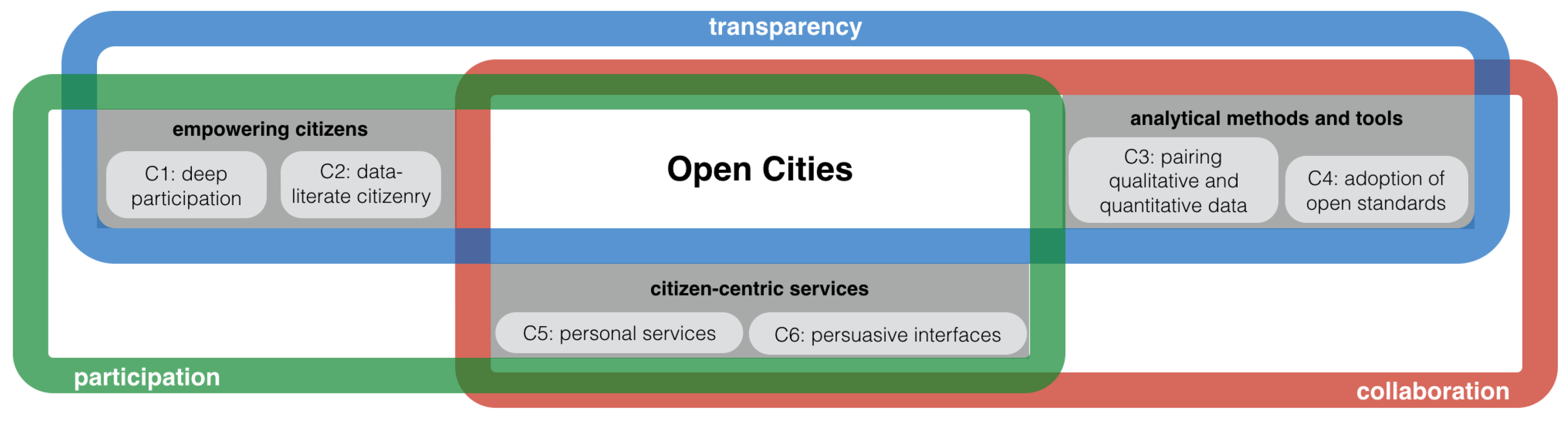
Several researchers have pointed out the importance of GIScience in the vision of smart cities. Contrary to [5], the survey presented by Brauer et al. [34] has a specific thematic scope: the impact of Green Information Systems on fostering environmental sustainability in smart cities. The authors point out the importance of GIS for collecting and monitoring environment-related data, but also for other smart city dimensions such as transportation, infrastructure, buildings and urban planning. Daniel and Doran [35] discuss potential contributions of geomatics to smart cities, with a focus on technologies, and the pervasiveness of geospatial information. They argue that the integration of ICT and geomatics tools is indispensable for the development of a smart city.
Roche [36] poses the question “what can GISciences do specifically to make cities smarter?”. He first extracts four dimensions of smart cities: the intelligent city (its social infrastructure), the digital city (its informational infrastructure), the open city (open governance), and the live city (its continuously adaptive urban living fabric). He then argues that: (i) GISciences can support the development of the intelligent city; (ii) GISciences can also support smart cities by dramatically enhancing the digital city dimension, and in particular the urban informational infrastructure; (iii) the governance dimension of smart cities (called ‘open city’) can benefit from recent advances in GISciences; and (iv) the live city dimension can also greatly benefit from GISciences, and especially from geodesign [37].
The work we present in this article is in line with Roche’s regarding the importance of GIScience in a smart city context, but there is an important difference in focus. Where Roche’s work emphasizes extracting current trends in the smart city context, we focus on tackling citizen-centric challenges using GIScience. We match GIScience contributions to citizen-centric challenges in order to shed some light on possible solutions rather than matching GIScience ideas to the four smart city dimensions, as Roche does. Finally, we point out a subtle but important issue, namely the use of the term GISciences in Roche’s work (in plural form; Roche leaves it undefined). In our work, we focus on the commonly accepted field of GIScience. The interested reader can refer to [38] for a recent discussion on the scope of GIScience.

3. Challenges

The trends which have been outlined in the previous section suggest that cities are the focus for many disciplines, ranging from social, economic and environmental sciences, architecture, design and urban planning, to social network analyses, sensor networks and human sensors. Regardless of the focus, recent experiences with smart city developments show that an important challenge is to expose, share and use data [39]. Nevertheless, opening up data without compelling incentives for developers, private companies, and citizens, along with a clear strategy and committed management by the data providers (e.g., public authorities) is most likely bound to fail [40].
Masip-Bruin et al. [10] enumerate three rationales behind the support of open data initiatives: (i) open data makes government more transparent, participative and collaborative, (ii) open data encourages public involvement in data collection, analysis and application, often reducing government spending or improving efficiency accordingly, and (iii) open data creates a new source of economic growth. Janssen et al. [9] also studied possible benefits of open data initiatives over smart cities. These covered a number of dimensions such as the political and social dimensions (e.g., more transparency, equal access to data), the economic dimension (e.g., simulation of innovation), and the operational and technical dimensions (e.g., external quality checks of data, sustainability of data).
Besides the benefits of open data for governments, citizens and businesses, there are also risks related to its publication that should be managed [41]. Open data is faced with issues in terms of risks, contingency actions, and expected opportunities in terms of governance, economic issues, licenses and legal frameworks, data characteristics, metadata, access, and skills [42]. Issues such as the unlawful disclosure of data, the infringement of trade secret protection, violations of privacy and breaches of the security of the infrastructure might have a severe negative impact. Therefore the compliance assessment and the quality control of the data being published should be implemented into the open data publication process. Where the primary data contains sensitive data like personal information, anonymization should be applied [41]. One criticism of current open data initiatives is that they are largely supply-driven (when they should be driven by the demand of citizens). Zuiderwijk and Janssen [43] put forward the idea that a context and dataset dependent decision-making model is needed to weigh the benefits of open data (e.g., creating transparency, the possibility to strengthen economic growth), against the risks and disadvantages of open data (e.g., violating privacy, possible misuse, false impressions, mismanagement issues and misinterpretation of data). Martin et al. [44] state that despite the development of open data platforms, the wider deployment of open data still faces significant barriers. The lack of insight into the user’s perspective and the lack of appropriate governance mechanisms can explain the large gap between the promises of open data and what is actually realized [9]. Finally, as [45] state, open data may increase the digital divide and social inequality unless approached right. The only sustainable basis for delivering public benefit from public data is therefore to motivate and enable communities themselves to innovate local service provision, social enterprise and job creation.
The challenge of opening up data can be considered at two levels: infrastructure data and citizen data [39,46]. Unfortunately, most infrastructure data in a city is still locked away, due to a variety of reasons: lack of resources, knowledge, technical skills, vision, etc. The “open data” movement, although gaining traction, has only scratched the surface of “freeing” this type of data [47]. There is a need of cheaper, accessible and better solutions to allow cities and infrastructure developers and maintainers to get their data out and expose it [48]. Citizen data is vital for cities—it’s a ground truth for citizens’ activities and desires—yet people are often unwilling to share data because they are concerned about privacy and trust issues [49]. We need to develop trusted data creators and certifiers, which will allow citizens to feel confident that they have complete control over the data they share (including the ability to revoke data sharing [50]), and who uses it for what purpose. Caragliu et al. [48] elaborate on the concept of smart cities as environments of open and user driven innovation for experimenting and validating Future Internet-enabled services. There is a need to clarify the way living lab innovation methods, user communities, Future Internet experimentation approaches [51], and test-bed facilities constitute a common set of resources. These common resources can be made accessible and shared in open innovation environments [52], to achieve ambitious city development goals. This approach requires sustainable partnerships and cooperation strategies among the main stakeholders [50].
Based on such critical pointers of development gaps in smart cities approaches, research themes and challenges directly tailored to citizens’ needs are brought forth in this section. Here, the assumption is that smart cities cannot become a reality unless citizens are central actors in shaping their cities [53]. Citizen-focused challenges for smart cities are not entirely new though. A 2015 CJRES’s special issue on “Thinking about smart cities” [54], for example, examined current perceptions on the goals, challenges, and limitations of smart cities beyond of infrastructure- and technology-intensive visions, to stress on greater equity, improved quality of life, and citizen empowerment. Also, smart city professionals recently interviewed before a Smart City Event held in Amsterdam (see [55]) highlighted similar challenges: collaboration among different stakeholders, adaptation for growth, as well as costs and funding.
The effect of the above citizen-focused vision for smart cities is palpable in our work. Empowering citizens, analytical methods and tools, and citizen-centric services research themes (Figure 1) are useful to improve transparency, facilitate participation, and ease collaboration in a city context. These challenges are not the only ones in smart cities, but they are crucial to better understand the spatiotemporal interactions between cities and citizens. For this reason, we stress in next sections the role of GIScience in the research themes and challenges discussed throughout the paper.

3.1. Empowering Citizens

Citizen empowerment is a dynamic process, whereby citizens get increasingly engaged with the services a city offers and with other fellow citizens. This process builds upon openness to enable citizens to share data, experiences and skills. It may provide an attractive environment to ultimately fuel transparency and data literate citizenry. Van den Bergh and Viaene [53] aptly identify two groups of cities: those that interpret a smart city based on high infrastructure demands, and the ones that opt for a smart citizen focus. The latter vision is consistent with a recent study by Kogan et al. [56], which identified citizen empowerment and engagement as the top success factor of a smart city project, thereby pushing ICT into the background. Put simply, without engaged and educated citizens on the access, creation, and interpretation of data and knowledge, a city may only be halfway smart and open.
  • Deep participation (C1): Recent works [9,57] have investigated citizen participation in various contexts, including smart cities, where people are often seen as data-collectors improving city services. Yet citizens are more than human sensors collecting data: deep participation is about raising awareness, building capacity, and strengthening communities [58]. There is a need to work with the community and not just for, or on, the community [59], and this must be reflected in the overall strategy to envision a smart city. Furthermore, city councils must pay special attention to the design and execution of strategies to foster citizen participation at all levels.
  • Data literate citizenry (C2): Smart cities are not only about ICT and infrastructures; smart cities are about smart citizens, who participate in their city’s daily governance, are concerned about enhancing the quality of life, and about protecting their environment. Data literacy should be a skill not just for scientists, but for all citizens. Cities can commit to open data, transparency and ICT as major enablers, but without the appropriate data literacy skills, co-creation and active participation with citizens is unlikely to occur. A key gap relates to how people can gain a sense of control. This necessitates fostering digital inclusion and data literacy skills to interpret and understand the processes and services that drive smart cities.

3.2. Analytical Methods and Tools

Cities need to connect macro (objective, aggregated data) and micro (subjective, citizen-generated data) observations to figure out how global phenomena (transport, mobility, energy, etc.) occurring at city scale relate to multiple citizen observations. Listening to what citizens sense and perceive, and acting consequently is a way of improving quality of life in cities. The analytical methods and tools theme contains the following research challenges:
  • Pairing quantitative and qualitative data (C3): Analysis methods that are able to integrate quantitative data and qualitative information through citizen science activities, social networks services, and crowdsourcing tools, will have a great impact on the future of our cities as more and more people live in urban areas [59]. In some cases citizens-generated data takes the form of measurements or quantitative observations (e.g., noise and air pollution measurements). In others such observations are more qualitative or subjective (e.g., opinions, emotions, behaviors) but no less useful. There is a need to move beyond the traditional quantitative analysis of physical phenomena to include also new analytical methods to scrutinize qualitative perceptions of the same phenomena as they are perceived by those who live in and sense the city. A preliminary look into the rationales and challenges involved in the integration of quantitative and qualitative geographic data was provided in [60]. In addition, the combination of datasets in the big data age needs to cope with a number of challenges listed in [20,61], for example efficient data representation, redundancy reduction and data compression, spurious correlations, and noise accumulation.
  • Adoption of open standards (C4): standards are essential to ensure that underlying technology, systems, data, applications and services are able to interact seamlessly in a coherent manner. Not only does standardization refer here to service interfaces, communication protocols, and architectures but also to data. The adoption of open data standards can dramatically unlock the potential of all citizens to access and use open data. Many cities wrongly assume that making data available, say in pdf format, is enough to be tagged as an open data city. Unless one is a developer that can code a pdf crawler, all this open data remains useless to other citizens (see concrete examples in [62]). Even though many cities are leaders in open data, there still exist barriers (e.g., the lack of open standards) impeding the access and use of such data broadly by people. The point is that small changes towards open standards can eventually lead to big impacts like making city services more transparent, participative and trustable.

3.3. Citizen-Centric Services

The citizen-centric services theme centers on the question of how to redesign existing services and/or provide new services that place citizens at the forefront. Citizen-centric services are emerging as an interaction paradigm linking citizens’ needs, skills, interests and their context to data-rich environments like cities.
  • Personal services (C5): As human beings, we only use a very small part of the retina, called the fovea [63], to see the finer details of objects that we are looking at. The rest of the visual field, which is known as peripheral vision [64], plays a key role even though it does not allow us to distinguish such details. When we detect an object that requires our interest in the sides, we quickly put the fovea on it to identify the object properly. Without the ability to detect the presence of other objects that surround us through our peripheral vision, our vision would be severely limited to a small portion of the visual field.
    Turning back to the smart city context, a research gap is the lack of customized and focused services, i.e., personal services, that are capable of adapting to the peculiarities and needs of each individual citizen, and that help them in performing daily tasks, provide them with up-to-date information, or simply support them in finding their way through the ever-increasing data stream sources available in today’s cities by presenting the clearest picture possible of what all this data means. These personal services augment our “peripheral vision”, to put in the forefront the pieces of information that could be relevant and might require our immediate attention.
    When it comes to personal data and services, privacy is an important issue to tackle. Janssen et al. [9] mention the unclear trade-off between transparency and privacy values as one of the adoption barriers of open data (and consequently of all benefits associated with the use of open data to make the city smarter). Solove [65] discussed the concept of privacy in detail and pointed out that it covers many aspects. Particularly relevant to the current discussion are:
    surveillance: the watching, listening to, or recording of an individual’s activities;
    aggregation: the combination of various pieces of data about a person;
    identification: linking information to particular individuals;
    secondary use: the use of information for a purpose other than what it was initially collected for, without the data subject’s consent;
    increased accessibility: amplifying the accessibility of information.
    Technological progresses, the open data movement, and the trend of big data provide an environment where the risk of privacy harms related to the five aspects above-mentioned is increased. For example, Lyon [66] mentions that “big data practices are increasingly important to surveillance”, and that “in a big data context, the same data are increasingly used for different purposes”. Linked Data, which helps to describe the content and context of resources (see [67]), eases aggregation and identification. The open data movement requires increased accessibility. As a result, reducing the risk for privacy violation (e.g., by putting the citizen fully in control of the kind of information s/he would like to disclose) is, in the current context, a major challenge.
    Regarding GIScience, the field has focused on location privacy. As Dukham and Kulik [68] stress, “[o]ur precise location uniquely identifies us, more so than our names or even our genetic profile”. Challenges mentioned in [68] regarding location privacy include (i) understanding the techniques a hostile person might employ in order to invade another person’s privacy, and (ii) the development of truly spatiotemporal models of location privacy.
  • Persuasive interfaces (C6): City governments pursue novel ways to engage with citizens as to better support their needs and concerns, and to involve them in decisions that affect them. Among the existing methods for getting citizens engaged (e.g., public consultations, local meetings, etc.), the creation of persuasive interfaces is getting importance as user interfaces are seen by citizens as the only “visible interfaces” between city services and themselves. The field of persuasive interfaces is not new; it can be traced back to Tversky and Kahnemann’s pioneering work on the prospect theory about framing decisions and psychology of choice [69]. City services need to go beyond traditional interfaces to pay attention to more user-centric interfaces that stimulate and encourage change. From the point of view of GIScience, the challenge lies not so much in design and psychology (which are important aspects), but in creating new types of user experiences that facilitate opportunistic interactions with citizens [70], and present information in such a way that citizens are persuaded to change their behavior and take actions accordingly. The stakes here are high, because citizens’ behavior plays an inescapable role against today’s most pressing environmental issues in cities [71].

4. Opportunities from GIScience

In this section, we look at the contributions from GIScience to address the social and technical challenges and research themes described in Section 3. GIScience has so many influences in multiple aspects of a city that it is a foundational part of smart cities for data acquisition, processing, analysis, representation, and visualization [72]. This is aptly synthesized by Gruen [73] in that “a smart city possesses spatial intelligence”. In the rest of the section, we look at each research theme, and point to existing work (i.e., research contributions, methods and tools) from GIScience that are relevant to address them.
Before going into what the GIScience community is doing, it is worth mentioning that from our perspective, the need to open up the city is a common denominator of many potential solutions to empowering citizens. The open data movement can be regarded as an engine for innovation, economic growth; as a way to create added-value services and applications; and to enhance efficiency, effectiveness, and cost savings at city level [74,75]. In this respect, recent case studies [57,76,77] have demonstrated that concrete actions can help governments to unleash the potential of public data to empower a transparent governance model (e.g., citizens can identify errors, prevent abuses, and inefficiencies), which ultimately builds trust between citizens and their cities [74,78]. Despite these benefits, open data initiatives are in reality far from operating at their fullest potential. Fortunately, some leading smart cities highlight the fact that citizen engagement and participation are success factors to stimulate the access and reuse of open city data by public and private stakeholders alike [79].

4.1. Empowering Citizens

Two main research challenges were introduced in Section 3 regarding the empowerment of citizens theme: deep participation (C1), and data literate citizenry (C2). Table 1 summarizes key contributions from the GIScience community with respect to empowering citizens.
  • Deep participation (C1): participation at all levels and by all citizens has attracted relatively few attention in the smart cities literature. Public participation GIS (PPGIS) was perhaps one of the first attempts to put geospatial capabilities, tools and applications in the citizens’ hands to enhance effective participation and communication among experts and non-experts. Even though PPGIS literature applies to many application domains in cities, decision-making processes in urban planing have quite probably been the domain by excellence for collecting and exploiting local knowledge from citizens through geospatial collaborative tools [80]. Geospatial visual methods, in varied forms, have been traditionally used to engage users and enable participation. Fechner and Kray [81] proposed an approach which relies on space and time as common integrators, and uses augmented interactive geo-visualizations to facilitate citizen engagement. They introduced three ideas, and exemplary tools, worth exploring in a smart city context: (i) synchronous distributed online collaborative mapping, (ii) the use of maps as spatial dialogue platforms, and (iii) the use of location-based services to highlight engagement opportunities both spatially and temporally.
    Improving deep participation in cities cannot be done without a deep understanding of the motivations of citizens to participate. Coleman et al. [82] provide a useful summary of contributors’ motivations (e.g., altruism, social reward, enhanced personal reputation, or mischief) to willingly produce geographic information. Since the very same contributors of geographic information are also actors (active or passive) in a smart city, deep participation strategies should take into account [82]’s synthesis about citizens’ motivations. Creating this type of win-win situations between city players is a critical success factor for smart cities, whereby city councils and organizations not just collect data and knowledge from citizens, but also give something back that is valued by citizens [59].
    Another example of this type of project is the Smart GraphHopper [83], which uses GraphHopper [84]. in order to plan routes and subsequently compare them by evaluating different available sensor data, such as noise, air pollution and so on. NoiseTube [85] uses this initiative to gather data from citizens’ phones.
    Gamification is a current trend to overcome the limitations of PPGIS tools and applications, and to foster citizen participation and engagement. Martella et al. [86] have produced a gamification framework for Volunteered Geographic Information (VGI [87]) which has three main parameters: the user, the tasks of the user (data gathering, data validation or data integration), and the types of datasets manipulated by the user. Along the same lines, [88] discussed a combination of social gaming, geospatial mobile tools and data collection campaigns to increase the network of volunteers to capture urban morphology for climate modeling purposes.
  • Data literate citizenry (C2): a data literacy strategy also requires simple and understandable presentations of existing datasets (e.g., in forms of visualizations or geo-visualizations). Fechner and Kray [81] argue that maps are one way of contextualizing and presenting primary data in an understandable and engaging way. As such, maps have a key role to play in the improvement of data literate citizenry. For example, [89] analyse measures describing the readability of maps themselves. Kraak [90] points out that maps have the ability to present, synthesize, analyze and explore the real world, and do this well because they visualize it in an abstract way, and only present a selection of the complexity of reality. Wakabayashi and Ishikawa [91] present the ability to organize, understand, and communicate with maps as one component of spatial thinking. As a result, insights from spatial thinking research can inform the design of better applications in a smart city context. For instance, the study documented in [91] concluded that people associate concrete spatial behavior in their daily lives (such as navigation and wayfinding in space, or sorting of furniture or packaging) with the act of thinking spatially. Uttal et al. [92] report that improving spatial thinking improves science, technology, engineering, and mathematics (STEM) achievements. This insight implies that part of making citizens smarter is the development of applications which help them improve their spatial thinking abilities.

4.2. Analytical Methods and Tools

Two main challenges were introduced in Section 3 regarding the analytical methods and tools theme: pairing quantitative and qualitative data (C3), and the adoption of open standards (C4). Table 2 recaps existing contributions of the GIScience useful to address challenges in this research theme.
  • Pairing quantitative and qualitative data (C3): relevant to the smart city context is the use of cellular automata to model cities. Cellular automata appear on Goodchild’s list [38] of major GIScience achievements. Cellular automata help to model the environment as adjacent cells [93]. Each cell has a state which refers to its attributes, and transitions between cell states are modeled using simple rules. A cellular model assumes only an action space (usually a grid), a set of initial conditions, and a set of behavior rules [94]. In other words, they can be interpreted as generators of growth and decline. The wide use of the SLEUTH cellular automata model (e.g. [95,96] for reviews of cellular automata applications) provides evidence that cellular automata is a technique worth considering to predict and simulate urban growth in a smart city context.
    So far, GIScience’s approach towards the integration of quantitative and qualitative data has been the use of observation ontologies which take into account both (e.g., [97,98,99]). These works have the concept of observation at the core of their investigations, and are based on the premise that all we know about the world is based on observations [100]. To make sense of observation data, GIScience has produced ODOE [101], the observation-driven framework for the engineering of geo-ontologies out of observation data. ODOE supports both human and technical sensors, and is therefore useful to consider when pairing quantitative (usually coming from technical sensors) and qualitative data (mostly produced by humans). Noteworthy also is the algebra for spatiotemporal data [102] which allows to derive objects and events from the three basic types of observations, namely time series, trajectories, and coverage. Stasch et al. [103] brought forth a theory which helps to enforce meaningful prediction and aggregation of observations. Kuhn [104] proposed eight ideas that many researchers found useful in their work on geographic information semantics:
    experiential realism: people conceptualize reality based on how they experience it through their bodies, sensing and acting in physical environments and in cultures;
    geographic information atoms: the simplest form of a geographic information is a tuple of location and attribute values;
    semantic reference systems: making the semantics of terms explicit and grounding them physically, so that transformations between them can be computed;
    semantic datum: useful to transform between different reference systems;
    similarity measurement: all semantics is context-dependent and can generally not be modeled objectively or even standardized;
    conceptual spaces: provide structures to solve conceptual problems through geometry;
    meaning as process: meaning comes from people using a word, rather than the words having a meaning on their own;
    constraining the process of meaning: tools can only be built to constrain the use and interpretation of terms, not specify their meaning. The latter presupposes a single meaning that one should strive towards defining, but as mentioned above, it is the people who mean something when they use terms in a specific context, not the terms which have a meaning per se. of these terms.
    Making sense of the wealth of available data in a smart city context can build upon these eight ideas. Finally, GIScience’s proposal of field as generic data type for big spatial data [105] is worth considering when dealing with issues of efficient data representation in a big data context.
  • Adoption of open standards (C4): In GIScience, standards of the Open Geospatial Consortium (OGC) [106]. The Open Geospatial Consortium is an international not for profit organization which develops open standards for the global geospatial community. See [107] for further details.) are used in a wide variety of domains including environment, defense, health, agriculture, meteorology, sustainable development, and smart cities. Recent works [108,109] identify the importance of open location standards to any smart city project and propose a spatial information framework for urban systems and spatial decision-making processes based on the integration of OGC open standards and geospatial technology. The combination of open standards (and APIs) such as OGC CityGML (e.g., 3D spatial city visualization), IndoorGML (e.g., indoor/outdoor navigation/routing to map indoor spaces), Moving Features, and Augmented Reality Markup Language 2.0 (ARML 2.0), would ease the delivery of geospatial features, imagery, sensor observations and geo-referenced social media in a coherent way, and thereby support interoperable and cross-domain city services for urban spatial intelligence, spatial visualizations, and decision making purposes.
    Sensors are crucial for intelligent systems like smart cities [110,111] and are well covered by the OGC Sensor Web Enablement (SWE) [112]. The OGC SWE standards suite specifies interfaces and metadata encodings to enable real-time integration of heterogeneous sensor networks [113]. In this way, most types of sensors can be discovered, accessed and reused for creating web-accessible sensor applications and services (see examples in [114,115]). For example, Mitton et al. [116] combined cloud-based services to process SWE-encoded sensing data in smart cities.
    When using mobile devices as ubiquitous sensing tools, OGC SWE protocols for data exchange between mobile devices introduce considerable overhead and performance penalties [117]. In addition, as SWE standards can be used for creating complex, time-consuming applications, such applications are often limited for resource-constrained devices [118]. As a result, and due to the need for compatibility with mainstream technology (e.g., IoT), the OGC has recently delivered the OGC SensorThings API [119] as a candidate standard. The OGC SensorThings API can be considered as a lightweight OGC SWE profile, that follows a REST-like style, and is particularly well suited for developing IoT-based sensing applications to interconnect resource-limited IoT devices. SEnviro [120], a low-cost, Arduino-based IoT device that monitors atmospheric variables demonstrated that IoT protocols and the OGC SensorThings API can work together for real-life smart cities applications.

4.3. Citizen-Centric Services

The citizen-centric services research theme comprises two specific challenges: personal services (C5) and persuasive interfaces (C6). Both model and shape the citizen’s personal relationship with a city, its services and places. Table 3 summarizes key features from GIScience useful to tackle each challenge.
  • Personal services (C5) may be regarded as the new generation of location-based services (LBS). The ability to know the location, both in out- and indoor environments, in real-time paves the way for smart city-specific advances in areas such as location-context systems, real-time tracking and routing, location-based advertising, and so on. Duckham [121] identified seven key principles of research into location privacy: (i) geographic space presents constraints to movement, (ii) humans are not random, (iii) large user-contributed datasets are biased, (iv) continuous and snapshot queries are different, (v) location privacy attacks are as important as location privacy protection, (vi) decentralization does not always improve location privacy, and (vii) location accuracy, and location precision are not synonyms (although both can be used to hide information about a person’s location). These principles were identified from location privacy research over recent years. Given that location (or the spatial dimension) is a very important component of smart cities (see, e.g., [35,36] for arguments in favor of such a view), privacy research in a smart city context can use these seven principles, as both starting points and guiding insights.
  • Regarding user-centric, more persuasive interfaces (C6), GIScience offers a theory of spatialization of user interfaces. In pioneering work, Kuhn [122] pointed out that “[s]pace is fundamental to perception and cognition because it provides a common ground for our senses as well as for our actions”, and discussed the need for spatial expertise in the field of human-computer interaction. He argued that designers need to be informed about human spatial cognition and properties of spaces in order to design more successful spatialized interfaces. His work introduced two key concepts for the design of intuitive user-interfaces: spatial metaphors and image-schemas. Both concepts are useful to understand how people think about space. A formalization of metaphors and image-schemas in the context of user interfaces was proposed in [123]. Recent work in GIScience [124] has looked at gestural interaction with spatiotemporal (linked) open data. In particular, gestures were considered helpful in engaging people with the visualization of complex data [124]. In summary, incorporating spatial elements and insights may help to provide more effective and intuitive interaction with (personal) smart city services.

4.4. Discussion

As the previous sections illustrate, GIScience may help to address citizen-centric challenges in smart cities. Two core pilars of GIScience, namely spatial representation and visualization, and spatial analysis, are particularly relevant for smart cities. GIScience has already developed useful standards, frameworks, formal specifications, techniques, approaches and principles (see Table 1, Table 2 and Table 3) that deal with the representation, understanding, analysing and visualizing spatial aspects of the world. These could be exploited to enforce the spatial component of smart cities. In addition, GIScience may also benefit from smart city initiatives. Indeed, a smart city not only consumes data to produce useful services, but it also generates a broad variety of data. For example, in a big city like London, about 45 millions journeys a week are generated from the smart card used by rail and buses passengers (see [125]. This wealth of data may serve as input for what Miller and Goodchild called data-driven geography [126]. Miller and Goodchild commented that with big data, the context of geographic research has shifted from a data-scarce to a data-rich environment. They described data-driven geography as an evolution of geography, and argued that it can provide the paths between idiographic (i.e., description-seeking) and nomothetic (i.e., law-seeking) knowledge.
Table 1, Table 2 and Table 3 also show that maps are a recurrent helpful component to address citizen-centric challenges. The map is explicitly present in approaches which aim at tackling the issues of deep participation (C1), and data literate citizenry (C2). It is also implicitly present in approaches for analysis (C3), the adoption of standards (C4) and the development of persuasive interfaces (C6). For instance, maps (and geoanalytics) are often used for visually informing end users about analysis results; OGC standards include the Web Mapping Service and the Web Map Tile Service specifications, both dealing with map rendering (see [108]); and maps also play a key role in gestural interaction [124]. All this indicates that maps are a central component for spatial representation and visualization in smart cities. Other related GIScience work, such as the underlying spatial representation models or alternative visualization techniques, are equally applicable in smart cities. In addition, spatial analysis is an invaluable part of understanding spatio-temporal data, detecting patterns and making predictions. In today’s expanding cities, where an explosive amount of organizational, participatory, demographic, environmental, and spatial data is present, the analysis techniques and solutions developed in GIScience are particularly relevant. Spatial analysis aspects are explicitly present in pairing quantitative and qualitative data (C3), adoption of open standards (C4), but also relevant for deep participation (C1) and personal services (C5). Example applications of spatial analysis include crime detection and prediction [127], green living and sustainability [34], traffic congestion and control [128].
Next to these core GIScience areas, other aspects which are not exclusive for the GIScience field, but have a strong spatio-temporal dimension, offer opportunities to address citizen-centric challenges in smart cities. Tons of geographic data come from citizens through pictures, tweets, geotags, reports, GPS tracks, VGI, (or more generally crowd-sourced data), is increasingly relevant for designing, improving, and assessing city services. Along with VGI, sensor networks and IoT devices are becoming much more pervasive in cities. Such devices are location-based and so location is central to realise context-aware and personal services for a great variety of city services and settings (e.g., outdoor and indoor services). While such IoT devices, sensors, and personal services accelerate the production and consumption of city services, such flows of data also introduce serious privacy and security concerns related to unforeseen uses of citizens’ location - an issue already considered in GIScience. Finally, alternative exploration and visualization techniques, such as virtual and augmented reality, provide new ways to present added value information and service, and present a new way to experience smart cities.
In a nutshell, there exists a symbiosis between GIScience and smart cities, and maps are critical in addressing citizen-centric challenges in smart cities. Yet, reaping the benefits of development in GIScience research for smart cities (and the other way round) will not be automatic. It depends on two factors: knowledge transfer, and the availability of open data (open data is the fuel of a data-driven science). The Open City Toolkit—a way of transferring insights and solution of GIScience to smart cities—intents to facilitate this knowledge transfer, and will be introduced in Section 5.1.

5. Towards the Realization of Opportunities from GIScience

The previous sections elaborated and discussed opportunities and achievements of GIScience to address smart city challenges, giving supportive evidence that GIScience contributions are key enablers to smart cities. Nevertheless, a full understanding of all the facets, benefits, and possibilities that GIScience can bring to smart cities is still at an early stage. The recently launched EU-funded European Joint Doctorate “Geoinformatics: Enabling Open Cities” (GEO-C) [129] targets a better understanding of this role, from a variety of perspectives. GEO-C’s overarching objective is to make substantial scientific progress towards the notion of smart (open) cities. It is worth mentioning at this point that, despite the availability of commercial solutions to tackle smart city issues (e.g., IBM Smarter Planet solutions [1]), there is still a lack of an integrated open source solution to support the move towards smarter cities. In this sesnse, Generic Enablers (GEs) built within initiatives such as FIWARE are a good first step, but more is needed, in particular an integrated piece of software which delivers useful services to citizens based on open data (in addition to independent software pieces). Besides the training focus of the GEO-C program, it is also a research project on its own to produce a joint-development of an Open City Toolkit (OCT). Subsequent subsections briefly introduce the vision of the OCT (Section 5.1) as well as example research directions at the intersection of GIScience and smart cities (Section 5.2).

5.1. The Open City Toolkit

In order to realize the opportunities outlined in Section 4 in a smart (open) city context, different methods can be applied, for example, technology-driven deployments of commercial systems, or citizen-driven participatory design of new urban services. These methods are subject to some limitations. In particular, they usually either favor technology or citizens, but rarely both. In addition, it is often not easy to combine individual solutions, and the transition process from a “non-smart” to a smart city is neglected. In order to overcome these issues, our research agenda envisions an Open City Toolkit (OCT) at its core, whose working definition is as follows:
The Open City Toolkit (OCT) is a collection of tools, processes, specifications and guidelines to empower citizens to participate in and shape the future of their cities, and to deliver services based on open data that are useful for citizens, businesses and governing bodies alike.
An important part of the OCT is an integrated, open source software empowering citizens, providing them with analytical tools and citizen-centric services in the context of a smart city. The OCT is therefore technology-driven and citizen-centric. The usefulness of the OCT is threefold: (i) provide software components addressing the challenges mentioned in Section 3; (ii) integrate work done in different facets of smart cities, as detailed further in this section, and (iii) transfer insights from GIScience to smart cities. In essence, five types of components are envisioned for the OCT:
  • A set of tools to improve transparency: to enable citizens to inspect what data is gathered and how it is used, and to visualize key indicators so that all stakeholders can understand them. Transparency relates to the visibility and inferability of the information (see [130]), while participation relates to the involvement of citizens in city operations. This work assumes that greater transparency will have a positive impact on citizen participation. The set of tools then relates to the challenges of deep participation (C1) and data literate citizenry (C2);
  • A curated set of examples of open source apps, open data and services: apps and services that are useful to cities/citizens, and relate to the challenges of pairing quantitative and qualitative data (C3), as well as the development of personal services (C5) and persuasive interfaces (C6);
  • An abstract architecture: describes how apps, processes, services and data can be integrated in order to realize a smart open city. This abstract architecture is to be built upon open standards (C4);
  • A “glue” to connect resources, apps and services to realize an open city: involves a set of APIs and specifications to link components and tap into data. This facilitates further development based on existing resources and artifacts, thereby opening up the smart city’s "living" ecosystem.
  • Guidelines on how to realize an open city: interactive guidelines describing insights about how to facilitate transparency, collaboration, participation using methods from GIScience. The guidelines will also document insights as to how to support the transition to a smart and open city.
By providing such a common, flexible framework/platform, and by fostering transparency, collaboration and participation, we intend to create a bridge between all stakeholders (councils, citizens, companies), between technology and society, and between research and practice. In addition, by incorporating city transformation guidelines and providing set of useful examples for developers and users alike, we aim to facilitate the transition towards smarter cities. Finally, by providing it as open source, any interesting party—be it city authorities, researchers, businesses, practitioners or citizens themselves—can easily obtain, use and/or build on it.
For example, the OCT as a platform will support the integration of existing or novel location-based services such as future transport services or location-based educational apps. When services are realized via the OCT or connected to it, they will benefit from the transparency and participation features built into the framework. These include users being able to identify which data sources are used by which service or being able to configure which services are executed in a smart city and how. Similarly, a broad range of data sources is supported. For example, data produced via a range of sensors using IoT technologies can be easily connected to the OCT. Once this is done, it is accessible for all services and apps running on the OCT, and can also be inspected with the transparency tools built into the OCT.
The OCT is currently being built using web technologies (first release expected by end of 2016). The primary target users are citizens and city councils, while keeping private companies and governmental institutions as key stakeholders in mind as well. In fact, the GEO-C consortium consists of a mix of city councils and private companies, and foresees links with government institutions and access to citizens via the projects’ host cities. All these stakeholders help to define the requirements for the OCT.
The Open City Toolkit will incorporate the results of the various research lines within the GEO-C project. In particular, it will keep all the data, processes, guidelines, standards, ontologies, frameworks and models open, and it will also provide utilities, tools and applications for open smart cities. To facilitate its use, it will incorporate search facilities to retrieve resources according to the specific purpose and needs, as well as browsing and exploration facilities.

5.2. Future Research Directions at the Intersection between Smart Cities and GIScience

In this section, we overview future research directions, summarised in Table 4, which are being pursued by the combined team of 30+ doctoral and post-doctoral researchers within the GEO-C project, and provide ample opportunities for other researchers in the field.
One of the research directions worth investigating for fostering citizen participation (C1) is the application of the openness principles to ensure that all citizens benefit from and participate in smart cities on all levels. Smart cities need informed and educated citizens who can participate on a deeper level, and can understand how sensed information is being used. Only then, can a win-win situation occur that permits to overcome crucial barriers in accessing, using, and interpreting open data [9].
Promising research directions are the combination of ideas and methods from VGI research, open data and open access, and human-computer interaction to develop hybrid approaches that widely engage diverse groups of people. For example, identifying and understanding the main motivating factors that characterize online citizen participation, and the production and use of VGI by citizens is essential. An interesting case study to explore these issues is the use of public displays as integrators in smart cities. Optimizing two-way information flows between citizens and public displays (i.e., city open data) is central for a timely provision of what they need, with minimal effort. Public displays may facilitate opportunistic and ad-hoc participation in decision-making as well as knowledge creation. Geoinformatics, cartography, maps, visual arts, and design can help citizens to understanding complex interactions by customizing the content that is being displayed. Especially in today’s cities, the traditional concept of maps that is strongly coupled to cartography needs to be updated, given that the lines between big data, cartography, and visual arts in mapping are increasingly blurred. Another future line to leverage deep participation is to explore the concept of virtual meeting geo-spaces to bridge the gaps between VGI and PPGIS, i.e., between citizens-driven (bottom-up) and administration-initiated (top-down) approaches. Such virtual meeting geo-spaces would permit a new communication channel to start a dialogue among citizens about a concrete geo-referenced item of interest to all involved participants.
With respect to data literacy (C2), the availability of suitable tools to turn citizens (from school children to seniors) into educated and informed citizens of smart open cities is vital to enhance digital literacy. A remarkable example with respect to data literate citizenry (C2) is the Open Data Institute (ODI) [131], which carries out mostly training, education, and promotion activities about the consumption and publication of public open data. The ODI’s programs are mainly targeted at developers and technically-skilled users who can transfer open data know-how to public and private organizations. This may foster open data literacy as a means to promote economic growth and innovation by facilitating the exploitation of open data capabilities, along the same line of the EC’s vision on data-driven economy [132].
Future work should complement the ODI’s vision by targeting citizens other than skilled developers, ideally in two ways. First, addressing user groups that are typically left out, such as children, disabled or elderly (technologically illiterate) people, is essential. For example, further research in educational tools for children, and accessibility of tools for various target groups, is required to enable all of them to become first-class smart citizens that are aware of their city environment and the city services provided to them, and are able to interact with them. Second, each citizen perceives, interacts with, and senses the city in distinct ways. This suggests that future research could identify and characterize how different groups of citizens perceive and understand cities. Children, elderly, workers, tourists and so on have distinct feelings, needs and perspectives of city services and city open data. The key point here is to identify the main impediments that make current open data, including cartography and geospatial datasets, not understandable and readable by these groups of citizens. This would allow to transform open data into a new type of active, customized open data maps tailored to each group’s needs and characteristics to improve user experience and satisfaction.
When it comes to exploring new analytical methods to integrate quantitative and qualitative data (C3), one direction of investigation involves the integration of spatiotemporal quantitative measurements and predictions, with qualitative assessments about an individual instantaneous location or usual areas/periods of preferential residence. Expected results included novel analytical methods to compute quality of life indicators based on heterogeneous data sources. Another interesting research avenue is the exploration of new analytical methods to downscale coarse environmental data at city level. This implies novel methods to jointly handle multi-scale, multi-temporal data sources like official climate records with citizen-generated observations.
Predictive modeling is an attractive niche for smart cities. Typical issues in cities such as traffic and pollution can be actively managed by foreseeing possible scenarios and properly reacting to them. In this context, one interesting future research line deals with the modeling of spatiotemporal interactions based on social networks and citizens’ digital footprints (e.g., GPS data) to improve the accuracy and timeliness of predictions. Concrete city applications could be predictions about the most likely crime spots and citizens mobility.
There are several opportunities for research on the adoption of open standards (C4). For example, there is a clear need for application frameworks for quickly creating and deploying standards-based participatory sensing applications. Such frameworks are crucial to speed up the deployment and delivery of participatory apps to citizens, thereby effectively empowering them in gathering/creating relevant sensory data. This data in turn provides valuable information for governing bodies and other stakeholders to improve city services and operations. In addition, with the increasing rate at which data is generated, the ability to have standards-driven data hubs for accessing and exposing real-time urban data streams coming from multiple sources is an interesting research avenue that may provide added value for a smart city.
The research challenge of personal services (C5) covers multiple aspects. We recently observe a growing interest in data privacy, especially related to location-aware applications [133]. In this respect, the identification and analysis of existing and potential scenarios for proximity-based opportunistic information sharing between citizens and/or city services are vital for securing privacy in personal services. Atzori et al. [19] envision a social layer on top of the IoT paradigm that takes concepts of cooperation and social relationships for the establishment and management of social relationships between smart things. This idea could be extrapolated to determine social roles and relationships that a given device may perform as a function of its actual location (indoor or outdoor) and their relation to other nearby devices or services.
Finally, we envision further developments towards the design and characterization of persuasive interfaces (C6). These interfaces can deploy gamification techniques [134] to, for example, stimulate green behavior or green living and to provide gentle but effective incentives to improve performance on a series of health and green indicators. Also, these interfaces can determine the extent to which technologies foster social changes and in behavior, and provoke subsequent action. In the context of green living, for example, it is important to monitor the behavior in space of a citizen, knowing when he/she is walking, riding a bike or driving, and to provide feedback in the form of persuasive messages about the ecological/environmental consequences of his/her actions.

6. Conclusions

Smart(er) cities have become a priority topic for academia, industry, government and policy makers alike, and need to be studied from a multi-disciplinary perspective. Given the number of ongoing smart city initiatives and efforts, each with their own focus, there is a risk of duplicating work if these different efforts are not aware of each other, and of the various (other) areas involved in smart cities. This article proposed to expose the outcomes of various relevant research disciplines in a simple but comprehensive manner to alleviate this risk, and used GIScience as exemplary research discipline to scope the discussion.
The paper provided a synthesis of smart city challenges, taking a citizen-centric perspective, and grouped the challenges according to research themes. We considered three research themes (i.e., empowering citizens, analytical methods and tools, citizen-centric services), with two challenges per research theme: empowering citizens necessitates tackling challenges related to deep participation and data literate citizenry; analytical methods and tools involve challenges regarding the pairing of quantitative and qualitative data, as well as the adoption of open standards; and citizen-centric services suggests more work on personal services and persuasive interfaces.
A look into the literature from GIScience has revealed that the field has already provided a number of contributions which are directly relevant to the aforementioned challenges. These include: the use of maps as a both spatial dialogue platforms, and ways of contextualizing and presenting primary data in an understandable way; the use of cellular automata as method for urban growth prediction and simulation; the use of observation ontologies for the integration of quantitative and qualitative (geographic) data; the suite of open standards developed by the Open Geospatial Consortium; the seven principles of research into location privacy; and the spatialization of user interfaces.
The article then proposed a number of future research directions, and introduced the Open City Toolkit as a way of (i) integrating the outcomes of work done along these research directions, and (ii) transferring these research outcomes (and GIScience research outcomes) to smart cities. Several research directions are currently explored within the GEO-C project, undertaken at the authors’ universities in collaboration with private companies and city councils. Examples include the use of public displays as integrators of open smart cities, the identification of impediments that make current open data not understandable and readable by certain groups of citizens (e.g., elderly), research in educational tools for children to make them aware of their city environment and the city services, a participatory sensing framework to facilitate citizen participation, explore the concept of virtual meeting geo-spaces to bridge the gaps between VGI and PPGIS, and the formalization of social roles on top of nearby devices and services. We also indicated additional interesting avenues for research.
In summary, GIScience is critical to address citizen-centric challenges in smart cities. Given the breadth of topics covered by both (i.e., GIScience and smart cities), any analysis attempting at clarifying their intersection will ultimately remain limited in scope, and biased towards the research interests of the authors. The article has only scratched the surface of how fruitful the intersection of the two areas could be, and calls for further discussions complementing the views exposed.

Acknowledgments

This work has been funded by the European Commission through the GEO-C project (H2020-MSCA-ITN-2014, Grant Agreement number 642332, http://www.geo-c.eu/). Carlos Granell and Sven Casteleyn have been partly funded by the Ramón y Cajal Programme (grant numbers RYC-2014-16913 and RYC-2014-16606 respectively). The authors thank Carl Schultz and Malumbo Chipofya who assisted in proofreading the article, and the rest of the GEO-C consortium (PhD students, scholars, and associate partners) for their valuable discussions over the past months on the topic of the paper.

Author Contributions

The idea of the literature review paper was developed jointly by all authors. A.D., C.G. and S.T. contributed to the formulation of research themes, opportunities from GIScience and ongoing scientific work within GEO-C. D.B. contributed to the compilation of smart cities trends, technologies, projects and initiatives, as well as to the description of the Open City Toolkit. S.C. contributed to the related work on smart and open cities, challenges, as well as the description of the Open City Toolkit. C.K. provided the representation of the proposed challenges into research themes, and contributed to formulation of the vision as well as the description of the Open City Toolkit.

Conflicts of Interest

The authors declare no conflict of interest.

References

  1. IBM Smarter Cities. Available online: http://www.ibm.com/smarterplanet/us/en/smarter_cities/overview/ (accessed on 11 February 2016).
  2. Microsoft CityNext. Available online: http://www.microsoft.com/en-us/citynext/ (accessed on 11 February 2016).
  3. D’Aquin, M.; Adamou, A.; Daga, E.; Liu, S.; Thomas, K.; Motta, E. Dealing with diversity in a smart-city datahub. In Proceedings of the Fifth Workshop on Semantics for Smarter Cities, Riva del Garda, Italy, 19 October 2014; pp. 68–82.
  4. CitySDK. Available online: http://www.citysdk.eu/ (accessed on 11 February 2016).
  5. Yin, C.T.; Xiong, Z.; Chen, H.; Wang, J.; Cooper, D.; David, B. A literature survey on smart cities. Sci. China Inf. Sci. 2015, 58, 1–18. [Google Scholar] [CrossRef]
  6. Nam, T.; Pardo, T.A. Conceptualizing smart city with dimensions of technology, people, and institutions. In Proceedings of the 12th Annual International Digital Government Research Conference: Digital Government Innovation in Challenging Times, College Park, MD, USA, 12–15 June 2011; pp. 282–291.
  7. González, A.; Villazón-Terrazas, B.; Gómez, J.M. A linked data lifecycle for smart cities in Spain. In Proceedings of the Fifth Workshop on Semantics for Smarter Cities, Riva del Garda, Italy, 19 October 2014; pp. 9–14.
  8. Ojo, A.; Curry, E.; Zeleti, F.A. A tale of open data innovations in five smart cities. In Proceedings of the 48th Hawaii International Conference on System Sciences, Kauai, HI, USA, 5–8 January 2015; pp. 2326–2335.
  9. Janssen, M.; Charalabidis, Y.; Zuiderwijk, A. Benefits, adoption barriers and myths of open data and open government. Inf. Syst. Manag. 2012, 29, 258–268. [Google Scholar] [CrossRef]
  10. Masip-Bruin, X.; Ren, G.J.; Serral-Gracia, R.; Yannuzzi, M. Unlocking the value of open data with a process-based information platform. In Proceedings of 15th IEEE Conference on Business Informatics, Vienna, Austria, 15–18 July 2013; pp. 331–337.
  11. Department for Business, Innovation and Skills. Smart Cities, Background Paper. Available online: https://www.gov.uk/government/uploads/system/uploads/attachment_data/file/246019/bis-13-1209-smart-cities-background-paper-digital.pdf (accessed on 13 October 2015).
  12. Boulos, M.N.; Tsouros, A.D.; Holopainen, A. Social, innovative and smart cities are happy and resilient: Insights from the WHO EURO 2014 International Healthy Cities Conference. Int. J. Health Geogr. 2015, 14. [Google Scholar] [CrossRef]
  13. Batty, M. The New Science of Cities; MIT Press: Cambridge, MA, USA, 2013. [Google Scholar]
  14. Celino, I.; Kotoulas, S. Smart Cities. IEEE Internet Comput. 2013, 17, 8–11. [Google Scholar] [CrossRef]
  15. Da Silva, W.M.; Alvaro, A.; Tomas, G.; Afonso, R.; Dias, K.; Garcia, V. Smart cities software architectures: A survey. In Proceedings of the 28th Annual ACM Symposium on Applied Computing, Coimbra, Portugal, 18–22 March 2013; pp. 1722–1727.
  16. Boulos, M.N.K.; Al-Shorbaji, N.M. On the Internet of Things, smart cities and the WHO Healthy Cities. Int. J. Health Geogr. 2014, 13. [Google Scholar] [CrossRef]
  17. Zanella, A.; Bui, N.; Castellani, A.; Vangelista, L.; Zorzi, M. Internet of things for smart cities. IEEE IoT J. 2014, 1, 22–32. [Google Scholar] [CrossRef]
  18. Vlacheas, P.; Giaffreda, R.; Stavroulaki, V.; Kelaidonis, D.; Foteinos, V.; Poulios, G.; Demestichas, P.; Somov, A.; Biswas, A.R.; Moessner, K. Enabling smart cities through a cognitive management framework for the internet of things. IEEE Commun. Mag. 2013, 51, 102–111. [Google Scholar] [CrossRef]
  19. Atzori, L.; Iera, A.; Morabito, G.; Nitti, M. The Social Internet of Things (SIoT)—When social networks meet the Internet of Things: Concept, architecture and network characterization. Comput. Netw. 2012, 56, 3594–3608. [Google Scholar] [CrossRef]
  20. Chen, M.; Mao, S.; Liu, Y. Big data: A survey. Mob. Netw. Appl. 2014, 19, 171–209. [Google Scholar] [CrossRef]
  21. Branchi, P.; Fernández-Valdivielso, C.; Matias, I. Analysis matrix for smart cities. Futur. Internet 2014, 6, 61–75. [Google Scholar] [CrossRef]
  22. Kehoe, M.; Cosgrove, M.; Gennaro, S.D.; Harrison, C.; Harthoorn, W.; Hogan, J.; Meegan, J.; Nesbitt, P.; Peters, C. Smarter Cities Series: A Foundation for Understanding IBM Smarter Cities. Available online: http://www.redbooks.ibm.com/redpapers/pdfs/redp4733.pdf (accessed on 1 October 2015).
  23. Menychtas, A.; Kranas, P.; Donovang-Kuhlisch, M.; Heindrichs-Krusch, M.; Coote, R.W.; Schade, U.; Osman, K.A.; Kallipolitis, L.; Graaf, S.V.D.; Brebels, W.; et al. D2.3 Online Service Delivery Baseline and Technical Requirements Report. European Platform for Intelligent Cities. No: 270895. Available online: http://www.epic-cities.eu/sites/default/files/documents/D2.3B%20Online%20Service%20Delivery%20Baseline%20and%20technical%20requirements%20report.pdf (accessed on 1 October 2015).
  24. Menychtas, A.; Kranas, P.; Donovang-Kuhlisch, M.; Schade, U.; Vasilescu, C.; Rana, P.; Brebels, W.; Kallipolitis, L.; Gastel, M.V. D2.1 Project Vision. European Platform for Intelligent Cities. No: 270895. Available online: http://epic-cities.eu/sites/default/files/documents/D2.1%20Project%20Vision.pdf (accessed on 1 October 2015).
  25. Donovang-Kuhlisch, M.; Heindrichs-Krusch, M.; Stoll, W.; Osman, K.; Kallipolitis, L.; Kranas, P.; Menychtas, A. D2.1 Project Vision. European Platform for Intelligent Cities. No: 270895. Available online: http://www.epic-cities.eu/sites/default/files/documents/D3.1B%20Technical%20Integration%20Architecture%20Plan.pdf (accessed on 1 October 2015).
  26. Angelidou, M. Smart city policies: A spatial approach. Cities 2014, 41, S3–S11. [Google Scholar] [CrossRef]
  27. Zaman, A.U.; Lehmann, S. Challenges and opportunities in transforming a city into a “zero waste city”. Challenges 2011, 2, 73–93. [Google Scholar] [CrossRef]
  28. McGrath, B.; Pickett, S. The metacity: A conceptual framework for integrating ecology and urban design. Challenges 2011, 2, 55–72. [Google Scholar] [CrossRef]
  29. Open Cities Consortium. Project Open Cities. Available online: http://www.opencities.net/content/project (accessed on 1 October 2015).
  30. Forum Virium Helsinki. What is CitySDK. Available online: http://www.citysdk.eu/about-the-project/what-is-citysdk/ (accessed on 1 October 2015).
  31. Open311 Organisation. A Collaborative Model and Open Standard for Civic Issue Tracking. Available online: http://www.open311.org/learn/ (accessed on 1 October 2015).
  32. Connected Smart Cities Network. Open and Agile Smart Cities. Available online: http://connectedsmartcities.eu/ (accessed on 1 October 2015).
  33. Usländer, T.; Berre, A.J.; Granell, C.; Havlik, D.; Lorenzo, J.; Sabeur, Z.; Modafferi, S. The future internet enablement of the environment information space. In Environmental Software Systems. Fostering Information Sharing; Springer: Neusiedl am See, Austria, 2013; pp. 109–120. [Google Scholar]
  34. Brauer, B.; Eisel, M.; Kolbe, L.M. The state of the art in smart city research—A literature analysis on green IS solutions to foster environmental sustainability. In Proceedings of the Pacific Asia Conference on Information Systems, Singapore, Singapore, 5–9 July 2015.
  35. Daniel, S.; Doran, M. GeoSmartCity: Geomatics contribution to the Smart City. In Proceedings of the 14th Annual International Conference on Digital Government Research, Quebec city, QC, Canada, 17–20 June 2013; pp. 65–71.
  36. Roche, S. Geographic Information Science I: Why does a smart city need to be spatially enabled? Prog. Hum. Geogr. 2014, 38, 703–711. [Google Scholar] [CrossRef]
  37. Steinitz, C. A Framework for Geodesign: Changing Geography by Design; ESRI Press: Redlands, CA, USA, 2012. [Google Scholar]
  38. Goodchild, M.F. Twenty years of progress: GIScience in 2010. J. Spat. Inf. Sci. 2010, 1, 3–20. [Google Scholar] [CrossRef]
  39. Rodger, L. Smart Cities: Technology Challenges. Available online: http://urbanopus.net/smart-cities-technology-challenges/ (accessed on 26 October 2015).
  40. Lee, M.; Almirall, E.; Wareham, J. Open data and civic apps: First-generation failures, second-generation improvements. Commun. ACM 2015, 59, 82–89. [Google Scholar] [CrossRef]
  41. Kucera, J.; Chlapek, D. Benefits and risks of open government data. J. Syst. Integr. 2014, 5, 30–41. [Google Scholar]
  42. Martin, S.; Foulonneau, M.; Turki, S.; Ihadjadene, M. Open data: Barriers, risks and opportunities. In Proceedings of the 13th European Conference on eGovernment, Como, Italy, 13–14 June 2013.
  43. Zuiderwijk, A.; Janssen, M. The negative effects of open government data-investigating the dark side of open data. In Proceedings of the 15th Annual International Conference on Digital Government Research, Aguascalientes, Mexico, 18–21 June 2014; pp. 147–152.
  44. Martin, S.; Foulonneau, M.; Turki, S.; Ihadjadene, M. Risk analysis to overcome barriers to open data. Electron. J. E-Gov. 2013, 11, 348–359. [Google Scholar]
  45. Roberts, T. The Problem with Open Data. Available online: http://www.computerweekly.com/opinion/The-problem-with-Open-Data (accessed on 5 January 2016).
  46. Accelerating Smart City Deployments: Challenges, Competitions and Collaborations from Smart Cities Around the Globe and Across the Region. Available online: http://www.smartcitiesweek.com/Pages/Detail/17254 (accessed on 26 October 2015).
  47. Schaffers, H.; Komninos, N.; Pallot, M.; Trousse, B.; Nilsson, M.; Oliveira, A. Smart cities and the future internet: Towards cooperation frameworks for open innovation. In Future Internet Assembly; Domingue, J., Galis, A., Gavras, A., Zahariadis, T., Lambert, D., Cleary, F., Daras, P., Krco, S., Müller, H., Li, M.S., et al., Eds.; Springer: Berlin, Germany, 2011; pp. 431–446. [Google Scholar]
  48. Caragliu, A.; Del Bo, C.; Nijkamp, P. Smart Cities in Europe. J. Urban Technol. 2011, 18, 65–82. [Google Scholar] [CrossRef]
  49. Hollands, R. Will the real smart city please stand up? Intelligent, progressive or entrepreneurial? City 2008, 12, 303–320. [Google Scholar] [CrossRef]
  50. Naphade, M.; Banavar, G.; Harrison, C.; Paraszczak, J.; Morris, R. Smarter cities and their innovation challenges. IEEE Comput. 2011, 44, 32–39. [Google Scholar] [CrossRef]
  51. Granell, C.; Havlik, D.; Schade, S.; Sabeur, Z.; Delaney, C.; Pielorz, J.; Usländer, T.; Mazzetti, P.; Schleidt, K.; Kobernus, M.; et al. Future Internet technologies for environmental applications. Environ. Model. Softw. 2016, 78, 1–15. [Google Scholar] [CrossRef]
  52. Batty, M.; Axhausen, K.W.; Giannotti, F.; Pozdnoukhov, A.; Bazzani, A.; Wachowicz, M.; Ouzounis, G.; Portugali, Y. Smart cities of the future. Eur. Phys. J. Spec. Top. 2012, 214, 481–518. [Google Scholar] [CrossRef]
  53. Van den Bergh, J.; Viaene, S. Key challenges for the smart city: Turning ambition into reality. In Proceedings of the 48th International Conference on System Sciences, Grand Hyatt, HI, USA, 5–8 January 2015.
  54. Glasmeier, A.; Christopherson, S. Thinking about smart cities. Camb. J. Reg. Econ. Soc. 2015, 8, 3–12. [Google Scholar] [CrossRef]
  55. The Biggest Challenges to Develop a Successful Smart City Project. Available online: http://www.smart-circle.org/smartcity/blog/biggest-challenges-develop-successful-smart-city-project/ (accessed on 29 October 2015).
  56. Kogan, N. Exploratory Research on Success Factors and Challenges of Smart City Projects. Master’s Thesis, Department of Business Administration, Graduate School, Kyung Hee University, Seoul, Korea, 2014. [Google Scholar]
  57. Lathrop, D.; Ruma, L. Open Government: Collaboration, Transparency, and Participation in Practice; O’Reilly Media, Inc.: Sebastopol, CA, USA, 2010. [Google Scholar]
  58. Townsend, A.M. Smart Cities: Big Data, Civic Hackers, and the Quest for a New Utopia; WW Norton & Company: New York, NY, USA, 2013. [Google Scholar]
  59. Craglia, M.; Granell, C. Citizen Science and Smart Cities; Number EUR 26652 EN; Publications Office of the European Union: Luxembourg, 2014. [Google Scholar]
  60. Degbelo, A.; De Felice, G.; Lee, J.H. Integration of quantitative and qualitative geographic data for disaster response: Research challenges. In Proceedings of the GI_Forum 2013, Salzburg, Austria, 2–5 July 2013.
  61. Fan, J.; Han, F.; Liu, H. Challenges of big data analysis. Natl. Sci. Rev. 2014, 1, 293–314. [Google Scholar] [CrossRef] [PubMed]
  62. How We Found the Worst Place to Park in New York City — Using Big Data. Available online: https://www.ted.com/talks/ben_wellington_how_we_found_the_worst_place_to_park_in_new_york_city_using_big_data (accessed on 26 October 2015).
  63. Fovea Centralis. Available online: https://en.wikipedia.org/wiki/Fovea_centralis (accessed on 11 February 2016).
  64. Peripheral Vision. Available online: https://en.wikipedia.org/wiki/Peripheral_vision (accessed on 11 February 2016).
  65. Solove, D. A taxonomy of privacy. Law Rev. 2006, 154, 477–564. [Google Scholar] [CrossRef]
  66. Lyon, D. Surveillance, Snowden, and big data: Capacities, consequences, critique. Big Data Soc. 2014, 1, 1–13. [Google Scholar] [CrossRef]
  67. Scheider, S.; Degbelo, A.; Kuhn, W.; Przibytzin, H. Content and context description—How linked spatio-temporal data enables novel information services for libraries. GIS Sci. 2014, 4, 138–149. [Google Scholar]
  68. Duckham, M.; Kulik, L. Location privacy and location-aware computing. In Dynamic and Mobile GIS: Investigating Changes in Space and Time; Billen, R., Joao, E., Forrest, D., Eds.; CRC Press: Melbourne, Australia, 2006; pp. 35–51. [Google Scholar]
  69. Tversky, A.; Kahneman, D. Advances in prospect theory: Cumulative representation of uncertainty. J. Risk Uncertain. 1992, 5, 297–323. [Google Scholar] [CrossRef]
  70. Hespanhol, L.; Tomitsch, M.; McArthur, I.; Fredericks, J.; Schroeter, R.; Foth, M. Situated interfaces for engaging citizens on the go. Interactions 2016, 23, 40–45. [Google Scholar] [CrossRef]
  71. Umpfenbach, K. Influences on Consumer Behavior-Policy Implications Beyond Nudging. Available online: http://ec.europa.eu/environment/enveco/economics_policy/pdf/Behaviour%20Policy%20Brief.pdf (accessed on 11 January 2016).
  72. Vinod Kumar, T.M. Geographic Information System for Smart Cities; Copal Publishing Group: New Delhi, India, 2014. [Google Scholar]
  73. Gruen, A. SMART Cities: The need for spatial intelligence. Geo Spat. Inf. Sci. 2013, 16, 3–6. [Google Scholar] [CrossRef]
  74. Domingo, A.; Bellalta, B.; Palacin, M.; Oliver, M.; Almirall, E. Public open sensor data: Revolutionizing smart cities. IEEE Technol. Soc. Mag. 2013, 32, 50–56. [Google Scholar] [CrossRef]
  75. Schade, S.; Granell, C.; Perego, A. Coupling public sector information and public-funded research data in Europe: A vision of an open data ecosystem. In Information and Communication Technologies in Public Administration: Innovations from Developed Countries; Reddick, C., Anthopoulos, L., Eds.; Boca Raton, FL, USA, 2015; pp. 275–298. [Google Scholar]
  76. Cabinet Office, MH Government. Open Data White Paper-Unleashing the Potential. Available online: https://data.gov.uk/sites/default/files/Open_data_White_Paper.pdf (accessed on 11 January 2016).
  77. Ratti, C.; Townsend, A. Harnessing residents’ electronic devices will yield truly smart cities. Sci. Am. 2011, 305, 42–48. [Google Scholar] [CrossRef] [PubMed]
  78. Fioretti, M. Open Data, Open Society: A Research Project about Openness of Public Data in EU Local Administration. Available online: http://www.dime-eu.org/files/active/0/ODOS_report_1.pdf (accessed on 1 October 2015).
  79. Department for Business, Innovation and Skills. Smart Cities International Case Studies: Global Innovators. Available online: https://www.gov.uk/government/uploads/system/uploads/attachment_data/file/249397/bis-13-1216-global-innovators-international-smart-cities.pdf (accessed on 29 October 2015).
  80. Bugs, G.; Granell, C.; Fonts, O.; Huerta, J.; Painho, M. An assessment of public participation GIS and Web 2.0 technologies in urban planning practice in Canela, Brazil. Cities 2010, 27, 172–181. [Google Scholar] [CrossRef]
  81. Fechner, T.; Kray, C. Georeferenced open data and augmented interactive geo-visualizations as catalysts for citizen engagement. eJ. eDemocr. Open Gov. 2014, 6, 14–35. [Google Scholar]
  82. Coleman, D.J.; Georgiadou, Y.; Labonte, J. Volunteered geographic information: The nature and motivation of produsers. Int. J. Spat. Data Infrastruct. Res. 2009, 4, 332–358. [Google Scholar]
  83. Smart GraphHopper. Available online: https://github.com/DIVERSIFY-project/SMART-GH (accessed on 11 February 2016).
  84. GraphHopper. Available online: https://github.com/graphhopper/graphhopper/ (accessed on 11 February 2016).
  85. Maisonneuve, N.; Stevens, M.; Niessen, M.E.; Steels, L. NoiseTube: Measuring and mapping noise pollution with mobile phones. In Information Technologies in Environmental Engineering; Springer: Berlin, Germany, 2009; pp. 215–228. [Google Scholar]
  86. Martella, R.; Kray, C.; Clementini, E. A gamification framework for volunteered geographic information. In Proceedings of the International AGILE 2015 Conference—Geographic Information Science as an Enabler of Smarter Cities and Communities, Lisbon, Portugal, 9–12 June 2015; pp. 73–89.
  87. Goodchild, M.F. Citizens as sensors: The world of volunteered geography. GeoJournal 2007, 69, 211–221. [Google Scholar] [CrossRef]
  88. See, L.; Fritz, S.; Perger, C.; Schill, C.; McCallum, I.; Schepaschenko, D.; Duerauer, M.; Sturn, T.; Karner, M.; Kraxner, F.; et al. Harnessing the power of volunteers, the internet and Google Earth to collect and validate global spatial information using Geo-Wiki. Technol. Forecast. Soc. Chang. 2015, 98, 324–335. [Google Scholar] [CrossRef] [Green Version]
  89. Harrie, L.; Stigmar, H.; Djordjevic, M. Analytical estimation of map readability. ISPRS Int. J. Geo Inf. 2015, 4, 418–446. [Google Scholar] [CrossRef]
  90. Kraak, M. Why maps matter in GIScience. Cartogr. J. 2006, 43, 82–89. [Google Scholar] [CrossRef]
  91. Wakabayashi, Y.; Ishikawa, T. Spatial thinking in geographic information science: A review of past studies and prospects for the future. Proced. Soc. Behav. Sci. 2011, 21, 304–313. [Google Scholar] [CrossRef]
  92. Uttal, D.H.; Miller, D.I.; Newcombe, N.S. Exploring and enhancing spatial thinking links to achievement in science, technology, engineering, and mathematics? Curr. Dir. Psychol. Sci. 2013, 22, 367–373. [Google Scholar] [CrossRef]
  93. Batty, M. Cellular automata and urban form: A primer. J. Am. Plan. Assoc. 1997, 63, 266–274. [Google Scholar] [CrossRef]
  94. Clarke, K.; Gaydos, L. Loose-coupling a cellular automaton model and GIS: Long-term urban growth prediction for San Francisco and Washington/Baltimore. Int. J. Geogr. Inf. Sci. 1998, 12, 699–714. [Google Scholar] [CrossRef] [PubMed]
  95. Clarke, K.; Gazulis, N.; Dietzel, C.; Goldstein, N. A decade of SLEUTHing: Lessons learned from applications of a cellular automaton land use change model. In Classics from IJGIS— Twenty Years of the International Journal of Geographical Information Science and Systems; Fisher, P.F., Ed.; CRC Press: City, Country, 2007; pp. 413–427. [Google Scholar]
  96. Chaudhuri, G.; Clarke, K. The SLEUTH land use change model: A review. Int. J. Environ. Resour. Res. 2013, 1, 88–105. [Google Scholar]
  97. Kuhn, W. A functional ontology of observation and measurement. In Proceedings of the Third International Conference on GeoSpatial Semantics, Mexico City, Mexico, 3–4 December 2009; pp. 26–43.
  98. Degbelo, A. Modelling the spatial and temporal resolution of a sensor observation. In Proceedings of the GI_Forum 2013—Creating the GISociety, Salzburg, Austria, 2–5 July 2013; pp. 71–80.
  99. Degbelo, A. Spatial and temporal resolution of sensor observations; IOS Press: Amsterdam, Netherlands, 2015. [Google Scholar]
  100. Frank, A. Ontology for spatio-temporal databases. In Spatio-Temporal Databases: The CHOROCHRONOS Approach; Sellis, T., Koubarakis, M., Frank, A.U., Grumbach, S., Güting, R.H., Jensen, C.S., Lorentzos, N., Manolopoulos, Y., Nardelli, E., Pernici, B., et al., Eds.; Springer-Verlag: Berlin, Germany, 2003; pp. 9–77. [Google Scholar]
  101. Janowicz, K. Observation-driven geo-ontology engineering. Trans. GIS 2012, 16, 351–374. [Google Scholar] [CrossRef]
  102. Ferreira, K.R.; Câmara, G.; Monteiro, A.M.V. An algebra for spatiotemporal data: From observations to events. Trans. GIS 18, 253–269. [CrossRef]
  103. Stasch, C.; Scheider, S.; Pebesma, E.; Kuhn, W. Meaningful spatial prediction and aggregation. Environ. Model. Softw. 2014, 51, 149–165. [Google Scholar] [CrossRef]
  104. Kuhn, W. Cognitive and linguistic ideas in geographic information semantics. In Cognitive and Linguistic Aspects of Geographic Space; Raubal, M., Mark, D.M., Frank, A.U., Eds.; Springer-Verlag: Berlin, Germany, 2013; pp. 159–174. [Google Scholar]
  105. Camara, G.; Egenhofer, M.; Ferreira, K.; Andrade, P.; Queiroz, G.; Sanchez, A.; Jones, J.; Vinhas, L. Fields as a generic data type for big spatial data. In Proceedigns fo the 8th International Conference on Geographic Information Science, Vienna, Austria, 24–26 September 2014; pp. 159–172.
  106. OGC. Available online: http://www.opengeospatial.org/ (accessed on 11 February 2016).
  107. Reed, C.; Buehler, K.; McKee, L. OGC consensus: How successful standards are made. ISPRS Int. J. Geo Inf. 2015, 4, 1693–1706. [Google Scholar] [CrossRef]
  108. Percivall, G. OGC Smart Cities Spatial Information Framework. Available online: http://www.opengeospatial.org/pressroom/pressreleases/2181 (accessed on 11 January 2016).
  109. Li, W.; Li, L.; Goodchild, M.; Anselin, L. A geospatial cyberinfrastructure for urban economic analysis and spatial decision-making. ISPRS Int. J. Geo Inf. 2013, 2, 413–431. [Google Scholar] [CrossRef]
  110. Dameri, R.P.; Rosenthal-Sabroux, C. Smart City: How to Create Public and Economic Value with High Technology in Urban Space; Springer: Cham, Switzerland, 2014. [Google Scholar]
  111. Hancke, G.; Silva, B.; Hancke, G., Jr. The role of advanced sensing in smart cities. Sensors 2012, 13, 393–425. [Google Scholar] [CrossRef] [PubMed]
  112. Sensor Web Enablement. Available online: http://www.opengeospatial.org/ogc/markets-technologies/swe (accessed on 11 February 2016).
  113. Bröring, A.; Echterhoff, J.; Jirka, S.; Simonis, I.; Everding, T.; Stasch, C.; Liang, S.; Lemmens, R. New generation sensor web enablement. Sensors 2011, 11, 2652–2699. [Google Scholar] [CrossRef] [PubMed]
  114. Devaraju, A.; Jirka, S.; Kunkel, R.; Sorg, J. Q-SOS—A sensor observation service for accessing quality descriptions of environmental data. ISPRS Int. J. Geo Inf. 2015, 4, 1346–1365. [Google Scholar] [CrossRef]
  115. Tamayo, A.; Huerta, J.; Granell, C.; Díaz, L.; Quirós, R. gvSOS: A new client for OGC Sensor Observation Service interface standard. Trans. GIS 2009, 13, 46–61. [Google Scholar] [CrossRef]
  116. Mitton, N.; Papavassiliou, S.; Puliafito, A.; Trivedi, K. Combining Cloud and sensors in a smart city environment. EURASIP J. Wirel. Commun. Netw. 2012. [Google Scholar] [CrossRef]
  117. Tamayo, A.; Granell, C.; Huerta, J. Using SWE standards for ubiquitous environmental sensing: A Performance analysis. Sensors 2012, 12, 12026–12051. [Google Scholar] [CrossRef] [Green Version]
  118. Vermesan, O.; Friess, P. Internet of Things Applications-From Research and Innovation to Market Deployment; The River Publishers: Aalborg, Denmark, 2014. [Google Scholar]
  119. OGC SensorThing API. Available online: http://ogc-iot.github.io/ogc-iot-api (accessed on 3 November 2015).
  120. Trilles, S.; Lujan, A.; Belmonte, O.; Montoliu, R.; Torres-Sospedra, J.; Huerta, J. SEnviro: A sensorized platform proposal using open hardware and open standards. Sensors 2015, 15, 5555–5582. [Google Scholar] [CrossRef] [PubMed]
  121. Duckham, M. Moving forward: location privacy and location awareness. In Proceedings of the 3rd ACM SIGSPATIAL International Workshop on Security and Privacy in GIS and LBS, San Jose, CA, USA, 2 November 2010; pp. 1–3.
  122. Kuhn, W. Handling data spatially: Spatializating user interfaces. In Proceedings of the 7th International Symposium on Spatial Data Handling, Delft, The Netherlands, 12–16 August 1996.
  123. Kuhn, W.; Frank, A. A formalization of metaphors and image-schemas in user interfaces. In Cognitive and linguistic aspects of geographic space; Frank, A.U., Mark, D.M., Eds.; Kluwer Academic Publishers: Dordrecht, The Netherlands, 1991; pp. 419–434. [Google Scholar]
  124. Bartoschek, T.; Pape, G.; Kray, C.; Jones, J.; Kauppinen, T. Gestural interaction with spatiotemporal linked open data. OSGeo J. 2014, 13, 60–67. [Google Scholar]
  125. Batty, M. Big data, smart cities and city planning. Dialogues Hum. Geogr. 2013, 3, 274–279. [Google Scholar] [CrossRef]
  126. Miller, H.; Goodchild, M. Data-driven geography. GeoJournal 2015, 80, 449–461. [Google Scholar] [CrossRef]
  127. Wang, F. Geographic Information Systems and Crime Analysis; Idea Group Inc: Hershey, PA, USA, 2005. [Google Scholar]
  128. Barba, C.; Mateos, M.; Soto, P.; Mezher, A.; Igartua, M. Smart city for VANETs using warning messages, traffic statistics and intelligent traffic lights. In Proceedings fo the IEEE Intelligent Vehicles Symposium, Alcala de Henares, Spain, 3–7 June 2012; pp. 902–907.
  129. GEO-C. Available online: http://geo-c.eu/ (accessed on 11 February 2016).
  130. Michener, G.; Bersch, K. Identifying transparency. Inf. Polity 2013, 18, 233–242. [Google Scholar]
  131. ODI. Available online: http://theodi.org/ (accessed on 11 February 2016).
  132. Commission of the European Communities the Council, the European Economic and Social Committee, and the Committee of the Regions. COM (2014) 442: Towards a Thriving Data-Driven Economy. Available online: http://eur-lex.europa.eu/procedure/EN/1042141 (accessed on 11 January 2016).
  133. Damiani, M. Location privacy models in mobile applications: Conceptual view and research directions. Geoinformatica 2014, 18, 819–842. [Google Scholar] [CrossRef]
  134. Deterding, S.; Dixon, D.; Khaled, R.; Nacke, L. From game design elements to gamefulness: Defining gamification. In Proceedings of the 15th International Academic MindTrek Conference: Envisioning Future Media Environments, Tampere, Finland, 28–30 September 2011; pp. 9–15.
Figure 1. Citizen-centric challenges grouped into three research themes: empowering citizens, analytical methods and tools, and citizen-centric services.
Ijgi 05 00016 g001
Table 1. Matching Geographic Information Science (GIScience) contributions to citizen-centric smart city challenges (Theme: empowering citizens). The use of maps is a promising approach to address both the issues of deep participation and data literate citizenry in a smart city context.
Research ChallengesExisting GIScience Contributions to Tackle the Challenges
Deep participation (C1)
Open Geographic Data and Open GIS
Synchronous distributed online collaborative mapping
Maps as spatial dialogue platforms
Location-based services as means to highlight engagement opportunities both spatially and temporally
Gamification approaches for Volunteered Geographic Information
Insights from GIScience research into contributors’ motivation
Data literate citizenry (C2)
Maps as one way of contextualizing and presenting primary data in an understandable way
Insights from spatial thinking research: improving spatial thinking improves STEM achievements
Table 2. Matching GIScience contributions to citizen-centric smart city challenges (Theme: analytical methods and tools). The suite of Open Geospatial Consortium (OGC) open standards is a good starting point for the exchange of (geospatial) information in a smart city context.
Research ChallengesExisting GIScience Contributions to Tackle the Challenges
Pairing quantitative and qualitative data (C3)
  • Observation ontologies taking into account both human and technical sensors
  • Cellular automata as a method for urban growth prediction and simulation
  • The observation-driven framework for the engineering of geo-ontologies
  • An algebra for spatiotemporal data
  • Insights from research in geographic information semantics
  • Fields as generic data type for big spatial data
Adoption of open standards (C4)
  • OGC open standards
  • OGC-based spatial information framework for urban systems and spatial decision-making
  • OGC SWE and cloud computing
  • OGC SensorThings API for IoT
Table 3. Matching GIScience contributions to citizen-centric smart city challenges (Theme: citizen-centric services). The seven principles of research into location privacy and the theory of spatialization of user interface can guide research into personal services and persuasive interfaces.
Research ChallengesExisting GIScience Contributions to Tackle the Challenges
Personal services (C5)
  • Seven principles of research into location privacy
Persuasive interfaces (C6)
  • Spatialization of user interfaces
  • Gestural interaction
Table 4. Example research directions at the intersection between GIScience and smart cities.
Research ChallengesGEO-C upcoming Features Beyond the State-of-the-Art
Deep participation (C1)
  • Identifying and understanding the main motivating factors that characterise online citizen participation
  • Explore the concept of virtual meeting geo-spaces to bridge the gaps between VGI and PPGIS
  • Public displays as integrators in open and smart cities; rethink the traditional concept of map as big data analysis, cartography, and visual art
Data literate citizenry (C2)
  • Educational tools for children to become citizen scientists
  • Active, customized open data maps that facilitate its full understanding to distinct groups of citizens
Pairing quantitative and qualitative data (C3)
  • Methods to integrate spatiotemporal quantitative measurements and predictions with qualitative assessments about an individual location
  • Methods to downscale coarse climatic data at city level
  • Predictive analytics for improved citizen mobility based on social networks and citizen’s digital footprints
  • Analysis of spatiotemporal interactions of crime data to predict crime hotspots in cities using data provided by the Web 2.0
Adoption of open standards (C4)
  • Framework for creating and deploying standards-based participatory sensing applications
  • Standards-driven data hubs for accessing and exposing real-time data streams
Personal services (C5)
  • Methods for proximity-based opportunistic information sharing and privacy protection
  • Determining social roles and relationships between nearby devices and/or services
Persuasive interfaces (C6)
  • Geospatial technology and visual interfaces for green behavior and/or living
  • Social implications of geospatial technology and location-aware interfaces for behavior changes

