Article

Spatiotemporal Degradation of Abandoned Farmland and Associated Eco-Environmental Risks in the High Mountains of the Nepalese Himalayas

1
Institute of Mountain Hazards and Environment, Chinese Academy of Sciences, Chengdu 610041, China
2
University of Chinese Academy of Sciences (UCAS), Beijing 100049, China
3
Wanzhou Key Regional Ecology and Environment Monitoring Station of Three Gorges Project Ecological Environmental Monitoring System, Wanzhou 404020, China
4
National Society for Earthquake Technology-Nepal, Kathmandu Lalitpur Po. Box 13667, Nepal
5
Central Department of Geography, Tribhuvan University, University Campus, Kirtipur Po. Box 44613, Nepal
*
Author to whom correspondence should be addressed.
Submission received: 30 October 2019 / Revised: 14 December 2019 / Accepted: 16 December 2019 / Published: 18 December 2019
(This article belongs to the Special Issue Agricultural Land Abandonment: Patterns, Drivers and Consequences)

Abstract

:
Globally, farmland abandonment has been a major phenomenon for eco-environmental and social landscape changes in the mountain regions. Farmland abandonment led to endangering the capacity of mountain ecosystems as well as variety of eco-environmental processes that play a pivotal role in regional as well local level eco-environment security. This research aims to (i) assess the spatiotemporal degradation of abandoned farmlands, (ii) identify the major causes of farmland degradation, and (iii) analyze the eco-environmental risks triggered or exacerbated by the degradation of abandoned farmlands. We conducted an inventory of the spatiotemporal distribution of abandoned farmlands and their degradation status with Google earth images and by modeling and interpreting low-height remote sensing images taken by an unmanned aerial vehicle (UAV). Geomorphic damages were mapped at the scale of individual abandoned farms. A multivariate regression statistical (MRS) model was used to identify the major causes of degradation. This research revealed that out of the total surveyed farmlands, 92% were already completely irreversibly damaged. The damages started with the disruption of terraces and bulging processes that occurred within the year after abandonment. This degradation induced diverse hazardous processes, such as landslides, debris flows, rock falls, the formation of gullies, soil erosion, and the development of sinkholes, which increase the negative effects of on both land resources and plant succession. Farmland abandonment does not automatically lead to plant colonization because geomorphic damage is intensified prior to colonization. Therefore, land management is required for plant colonization as well as other efforts to reduce degradation induced eco-environmental risk. This study thus could help land planners and environmentalists in the development of suitable guidelines (pre- or post-abandonment) plans, programmes, and legislation to effectively address the problem of abandoned farmland.

1. Introduction

Farmland use is important not only for agroecosystem services but also for eco-environmental security in the mountain regions [1]. In particular, farmland management systems took into account environmental factors, allowing land uses according to the physical potential of the territory (including topography, climate, relief, soil) and the distance to roads and settlement contributing to eco-environmental diversity in the mountains, and to the sociocultural values of the landscape [2,3]. However, in recent years, farmland abandonment has been one of the most important phenomena in many mountainous countries of the world [4,5,6,7,8,9,10,11]. Globally, it is estimated that approximately 385–472 million km2 of farmland have been abandoned, accounting for 8%–10% of the worlds cultivated farmlands [12]. Farmland abandonment led to new eco-environmental conditions: vegetation recolonization on one side, and soil erosion siltation of rivers and reservoirs on the other side [13]. In addition, farmland abandonment accelerates the incidence and severity of landslides, debris flow, rock falls, and sinkholes [7,14]. Moreover, farmland abandonment leads to homogenization of the mountainous landscape and the disappearance of traditional landscapes, which have serious socioeconomic implications [15]. Thus, farmland abandonment and the consequent conservation problems and issues of management of the regional ecological environment have become increasingly challenging for the nation [10,16].
Understanding the spatiotemporal degradation of farmlands, the patterns of damage, and the major drivers of change is instrumental for synthesizing knowledge for informed land resource management planning, regional ecological environment planning, and a host of other associated decisions, such as early warning systems for disasters and ecosystem services [8]. This provides interconnected environmental issues and relevant processes interaction in the pedosphere. These processes pave the way towards awareness raising related to farmland and their degradation. In addition, they provide scientific reference for the future policy development on mountainous ecosystems and biodiversity at global, regional, and national scale. However, the most important thing is the potential of farmland abandonment study to contribute to solving the major societal challenges such as life and livelihoods that depend on them, represented by United Nations sustainable development goals [17]. Thus, access to and accurate analysis of such information is essential [18]. While most global research on abandoned farmland has mainly focused on the causes and extent of abandonment [19,20,21], several scientific studies have addressed other topics, such as biodiversity [22], vegetation succession and bird interactions [23], changes in the microbial contents and infiltration rates of soils [24], variations in fungal mass [25], and the effects of afforestation on abandoned farmlands [26]. Empirical evidence from an investigation on the spatiotemporal degradation of abandoned farmlands at the local and regional scales is still lacking, especially in mountainous developing countries, such as Nepal. Moreover, we were also inspired by the statements of Hobbs et al. (2005) regarding biophysical, climatic, social, and other neighborhood variables (e.g., distance to settlement, road, and river, etc.) that might lead to a greater range of processes of landscape modification [27]; therefore, we decided to study the dynamics of farmland landscapes to evaluate the status of the land and to solve local and regional problems in the fragile Himalayas.
Nepal is a mountainous country in which the livelihood of 65% of the households depend upon farmland activities [16]. The entire rural population depends upon agriculture as their mode of vocation. A majority of cultivated farmlands in the mountainous parts of the country are located on hill slope inclines. Even steep and very steep slopes near the settlements are usually terraced for cultivation. For the most part, oxen-driven ploughs are used to till the fields. Indigenous knowledge and a system of mutual labor support called “Parma” is mostly used to cultivate and to maintain the farmlands [28,29]. Livelihoods and the management of land has changed rapidly in recent years mainly because of out-migration of the youth to cities and other countries [30]. This has led to a massive abandonment of existing cultivated farmlands all over the country [11,31,32,33,34,35]. However, there is virtually no system for inventorying abandoned farmlands and there is a large gap in the study of physical and socioeconomic processes and how these processes were impacted by the abandonment of farmland in the country. The research presented here aims to examine the process and effects of farmland abandonment by using a case study from one of the mountainous river basins that has a significant population dependent on farmland activities. This study is the start of much-needed expansion in this area of research.
This study aims to (i) assess the spatiotemporal degradation of abandoned farmlands, (ii) identify the major causes of farmland degradation, and (iii) analyze the eco-environmental risks triggered or exacerbated by the degradation of abandoned farmland. We considered plot level indicators of physical degradation to qualify the seriousness of the damage, to explain the consequences and to assess the environmental risk resulting from the abandonment of farmland. This study includes a comparative evaluation of land degradation over different geomorphic and geological conditions and different time periods, and the resultant eco-environmental consequences to the region. Thus, this study provides scientific evidence needed for land use planners and policy makers to take steps towards reformation, to understand the causative factors, and to promote the best management practices for addressing the abandoned farmlands in the mountainous landscape. Furthermore, this study could help to develop suitable guidelines, plans, programmes, and legislation to effectively address the increasing problem of farmland abandonment in the ecologically fragile mountainous regions of Nepal.

2. Materials and Methods
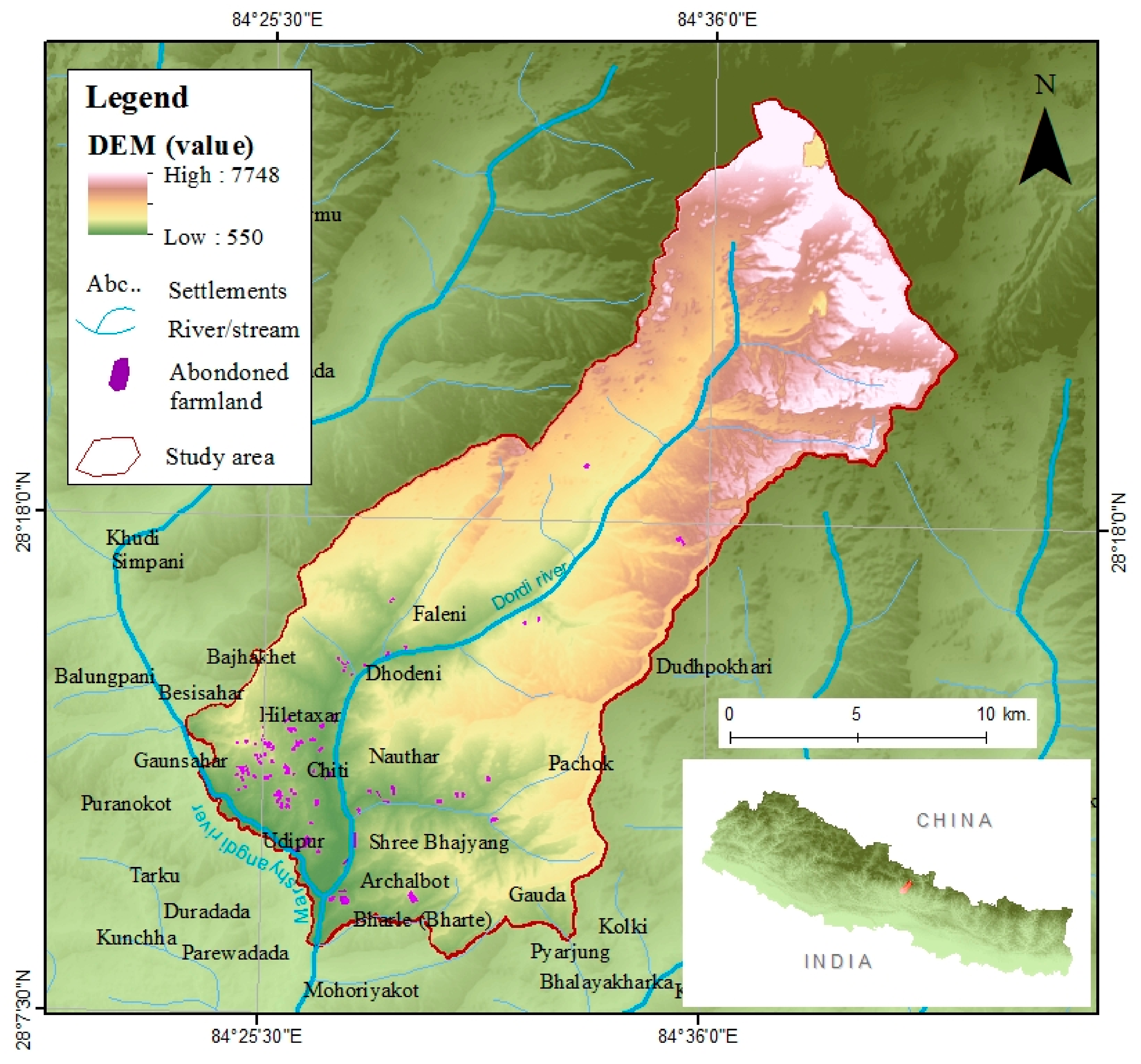
2.1. Study Area

The study was conducted in the Dordi River basin, located between 28°8′N–28°27′N latitude and 84°24′E–84°42′E longitude. The basin lies in a lateral spur of the high Himalayan region (Figure 1) covering a surface area of 498 km2 that rises from 546 to 7746 meters above mean sea level. It has a very pleasant mountainous subtropical climate, with an average annual precipitation of approximately 2600 mm and a mean annual temperature between 10 and 29 °C. Mean monthly rainfall is highest during July and August. Administratively, the basin lies in Gandak Pradesh (province no. 4) of western Nepal and is divided between the Dordi rural municipality and the Besisahar municipalities of the Lamjung district. The area is connected from Kathmandu by a 170-km all-weather metallic road that extends to Udipur along the Dumre Besisahar road.
Geologically, the basin is composed of the layers of easily weathered weak rocks, such as shale and phyllite of the Ranimatta formation; moderately hard slates of the Ghanapokhara formation and hard quartzite’s of the Naudanda formation [36]. The weaker rocks produce moderate to gentle hill slopes along which the cultivated lands are developed over colluvium. The hard quartzite forms the cliffs and steeper landforms. Alluvial terraces are limited to the banks of the river tributaries. Red soil, sandy, cobbly, loamy, loamy-boulder, and loamy-skeletal are the dominant soil types, mainly occurring on mountain slopes. In general, soil depths range from 20 cm to 1 m in farmland [36]. In agricultural terms, the soils on the mountain slopes appear to have been described as Regosols and Cambisols.
The basin has a rich biodiversity. It is a major refuge for native flora, fauna, and ecosystem services. It supports approximately 53 types of ecosystems (52 types of forests and one cultivated farmland ecosystem), which provide essential services to mountain settlements. Dominant forest vegetation include the chir pine (Pinus roxburghii) and broad-leaf led trees, such as chilaune (Schema wallichii), oak (Quercus semicarpifolia), sal (Shorea robusta), Schima, Castanopsis, and Engelhardtia [36]. During the last decades, these plants spread both through natural succession and reforestation, although shrubs still occupy large areas, especially abandoned farmland, due to natural succession. The succession of chir pine (Pinus roxburghii) and broad-leaf trees, such as chilaune (Schima wallichii), oak (Quercus semicarpifolia), sal (Shorea robusta), Schima, Castanopsis, and Engelhardtia, is much less. The human population is largely dependent upon forest resources for their livelihood.
The basin covers six major types of land use: (i) Khet (wet terrace), (ii) Bari (dry terrace), (iii) Pakho (slope land covered with shrubs and grazing herbs), (iv) Charan (grazing land), (v) Ban (forest), and (vi) Gaun (settlement). Forest is the dominant land use accommodating 42% of the area, followed by farmland and grassland 21% and 11% respectively. In general, Khet is levelled, bounded, and irrigated. The terraces located at lower elevations are generally larger, irrigated, and more fertile than those located on the steeper slopes at higher elevations; therefore, the lower elevation terraces are highly valued since they allow farmers to grow key staples of rice and wheat. Lower elevation terraces especially on river banks are prone to flooding, while terraces at higher elevations are vulnerable to collapse of individual terrace-risers, as well as to gradual or sudden slumping of entire hillsides [36]. Bari is a sloping rain-fed terrace found predominantly on moderate and steep hillsides at higher elevations. Bari soils are usually poor, sandy, and mixed with boulders in a loose matrix. Bari crops range from maize, legumes, radishes, mustard, and other vegetables in the summer to occasional millet and buckwheat in the winter. Farmers attempt to farm Bari land for essential staple crops; the maintenance of Bari lands is less demanding than that of Khet. In general, Bari terraces are prone to erosion, gullying, and sliding. Pakho is untilled land usually located on rocky, infertile, or steep slopes. It is prone to rock falls, landslides, debris flows, and erosion. Charan is usually denuded community-owned naturally grassland, used for cattle grazing. Erosion and landslides are common. Ban refers to forests, including small government-owned or private holy groves near settlements. People sometimes illegally exploit the forest for resources such as timber, fuel, and livestock fodder. Gaun, or village, denotes human settlements ranging from 5 to 100 households in size, most often located near springs and rivulets and major pathways or roads, and often interspersed with Khet or Bari lands; these settlements are subjected to erosion, slumping, and sliding.
The inhabitants belong to diverse ethnic groups, such as the Brahmin, Chhetri, Gurung, Magar, Newar, Tamang, Dalit, and Sarki. Settlements in the basin area are both nucleated and dispersed. Socially dominant ethnic groups such as Brahmins and Chhetri tend to occupy the highly valued lower, flatter, and irrigated lands. The Gurung occupy the middle slope lands and the generally marginalized “Janajati (indigenous ethnic group)” group, such as the Tamang and Magar groups, farms the steeper, rain-fed slopes at higher elevations. The 2011 census recorded a total population of 30,000 in the Dordi river basin, with a very high rate of outmigration (more than 50% households with at least one migrant) especially for young males [31]. Human activities such as road construction, construction of water supply systems, electric supply distribution, telecommunication networks, and construction of playgrounds and tourism recreation centers have increased in recent years and there is scarcity of local youth labor.
The abandonment of cultivated farmlands in the river basin has continued over the last three decades; however, no published statistics are available on land abandonment, as is the case for all of Nepal [11]. Our field observation estimates suggest that by 2018 approximately 8% of the farmland areas in the Dordi river basin were abandoned. We believed this abandonment rate has accelerated more since 2018. These details explain the choice the author made in selecting the research area for this research.

2.2. Data Acquisition and Processing

Datasets used to characterize abandoned farmlands were obtained from both a field survey and secondary sources. Biophysical variables, such as the elevation of each farmland area, were directly recorded in the field using a Trimble GeoXM Global Positioning System (GPS ±3 m precision). Slope and aspect were estimated from 30 × 30-meter-resolution digital elevation model from data prepared by the US National Aeronautics and Space Administration (NASA). Soil types were derived from the land resource mapping project database of Nepal [36]. Similarly, the climatic variable rainfall was obtained from the Nepal Department of Hydrology and Meteorology. The neighborhood-related variables, such as the proximity to river, roads, settlements, and other major constructions, were generated using Arc GIS 10.1 (Environmental Systems Research Institute, Redlands, CA, USA). Data collected from the Survey Department of Nepal were used for the neighborhood factors. Moreover, the presence of grazing, mining, and wildfire activities on 118 abandoned farmlands ranges from 0.2 to 10 ha in areas were surveyed during the field visit. The data categories and their units and sources are summarized in Table 1.

2.3. Assessment of Spatiotemporal Degradation of Farmland

The author used Google earth images to initially record the spatiotemporal distribution of abandoned farmlands. An A1 print of the recently downloaded 2018 Google earth image was used to locate the farmlands. Members of ward offices, elected presidents, teachers, social mobilizers, and villagers marked the hard copy of the Google image, indicating the location of the abandoned farmland and the date at which the abandonment started. Throughout the process, many abandoned farmlands were identified and categorized according to the time of abandonment: <2, 2–5, 5–10, 10–15, 15–20, and >20 years. Then, an unmanned aerial vehicle (UAV)-DJI Phantom 4 Pro plus Quadcopter with Deluxe Controller—CP.P.T.000549 was used to capture low-height remote sensing images of each abandoned farm. More than 5000 images (4000 × 3000 pixels in size) were collected and combined using Agisoft Photo Scan Professional-64 bit (Agisoft LLC 11 St. Petersburg, Russia). A holistic view from the UAV images allowed the identification of feature-based damage processes and the interpretation of geomorphic hazards (Figure 2). Additionally, ground-truthing was conducted in the field. An inventory form was developed and used to record each abandoned farm and its attributes, such as its location, size, present use, presence and curvature of the terraces, and vegetation coverage. Altogether, 118 abandoned farms were observed and assessed. The field study was conducted from September to December 2018.
The status of a farmland and its degradation was categorized into four classes, as follows:
(i)
Swelling—damage to the terraces’ uppermost thin soil layer with cracks similar to desert pavement, which developed due to displacement and removal of the particles. In this case, terrace surfaces or walls laced with layers of certain types of layers generally bear no depth of damage.
(ii)
Upsetting—terraces tilted at irregular spaces. This feature marked terraces that were easier to break or were easily eroded. This was an extremely dangerous condition threatening sudden and catastrophic terrace collapse.
(iii)
Bulge—terraces that were opened beyond their original shape were noted as bulging. In this condition, individual terraces or a portion of an individual terrace was opened, unstable, and had collapse features. This condition was harder to maintain.
(iv)
Collapse—structural failures, in which boulders or lithospheric materials were embedded along the terraces, which manifested at collapsed areas. The material beneath the collapsed landforms played a significant role in the geomorphic evolution.

2.4. Selection of Causes of Farmland Degradation

In the mountain region, farmland was revealed in both the natural and the built environment, which has the potential to affect farmland use, eco-environmental quality, and degradation [3,37,38,39]. Physical factors such as topography, altitude, slope, orientation, rainfall, soil texture, and geology are edaphic characteristics that primarily control the use of farmland and the geomorphic processes [40,41,42]. Socioeconomic activities, such as the age of abandonment, grazing, and mining/soil digging contribute to the sensitivity of a farmland landscape to degradation or geomorphic processes [43,44,45,46]. Similarly, the accessibility to and areal distances from roads, settlements, forests, and major construction centers play a major role in accelerating farmland landscape surface processes [19,20]. Therefore, the authors selected 10 variables that are active in all land use types and geomorphological conditions. These are categorized into biophysical characteristics (elevation, slope), climatic conditions (annual precipitation), socioeconomic activities (age of abandonment, grazing, mining/soil digging), and farmland neighborhood relationships (distance to roads, river/streams, settlements, and forests) (Table 2). Analysis of these factors vis-à-vis helped us identify the major factors contributing to the degradation of abandoned farmlands.
A multivariate regression statistical (MRS) model was run to characterize the relative contribution and importance of farmland characteristics in explaining degradation. The computer software Statistical Package for the Social Sciences (SPSS) version 23 (IBM in Armonk, NY, USA) was used to run the MRS model. Farmland characteristics as dependent variables were assessed from the primary field survey and secondary data, such as slope gradient, grazing and mining activities as independent variables, were used to run the model to obtain the coefficients of each property that caused terrace failures. The resulting values of the multivariate regression coefficients, which allow us to compare the strength of the relationship between the dependent variable and different independent variables, were standardized according to Menard [47].

2.5. Analysis of Hazard and Risk

To analyze the hazard and risk, we used the same taxonomy as used in studies conducted in the Hindu Kush Himalayan region, Swiss Alps and Colorado Rocky mountains [48,49,50,51,52]. Small failures that take place at the edges of terraces or directly related to vertical erosion were marked as landslides [53]. Terrace movements that involve water charged, predominantly coarse grained material, pebbles and boulders, flowing rapidly down a steep slope, were characterized as debris flows [54,55]. Rills and or soil cuts across the section of terraces were defined as gullies [56]. Rock falls following land degradation include differently sized individual rocks and boulders, seemingly strewn in a random and erratic manner. The wearing away of farmland topsoil by the natural forces of water were referred to as soil erosion [57,58]. Additionally, holes that formed in farmland surfaces that conduct surface water to an underground passage were mapped as sinkholes. Field observations and a holistic view of UAV images allowed objective evaluations of each hazardous process (damage features and their dimensions). The spatial patterns were thus easily detected and visually interpreted.
Risks were perceived as adverse consequences and disruptions on abandoned farmlands and human made infrastructures that undermine the health, productivity, and stability of environmental resources and their interactions [59]. Local farmers were consulted for additional information about processes that changed the abandoned landscape over time. These observations were supplemented by interviews with local ward officials. A checklist with the defined criteria for every kind of hazardous process and their consequences was used for the risk analysis. Altogether, 118 abandoned farms were observed and assessed for the hazard risk analysis.

3. Results

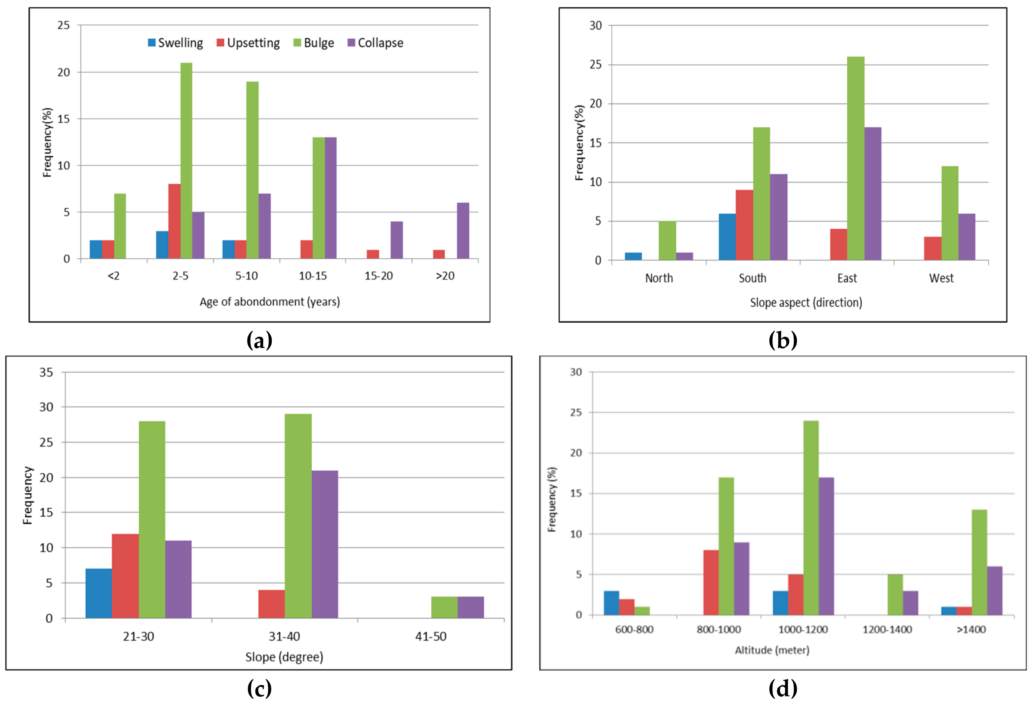
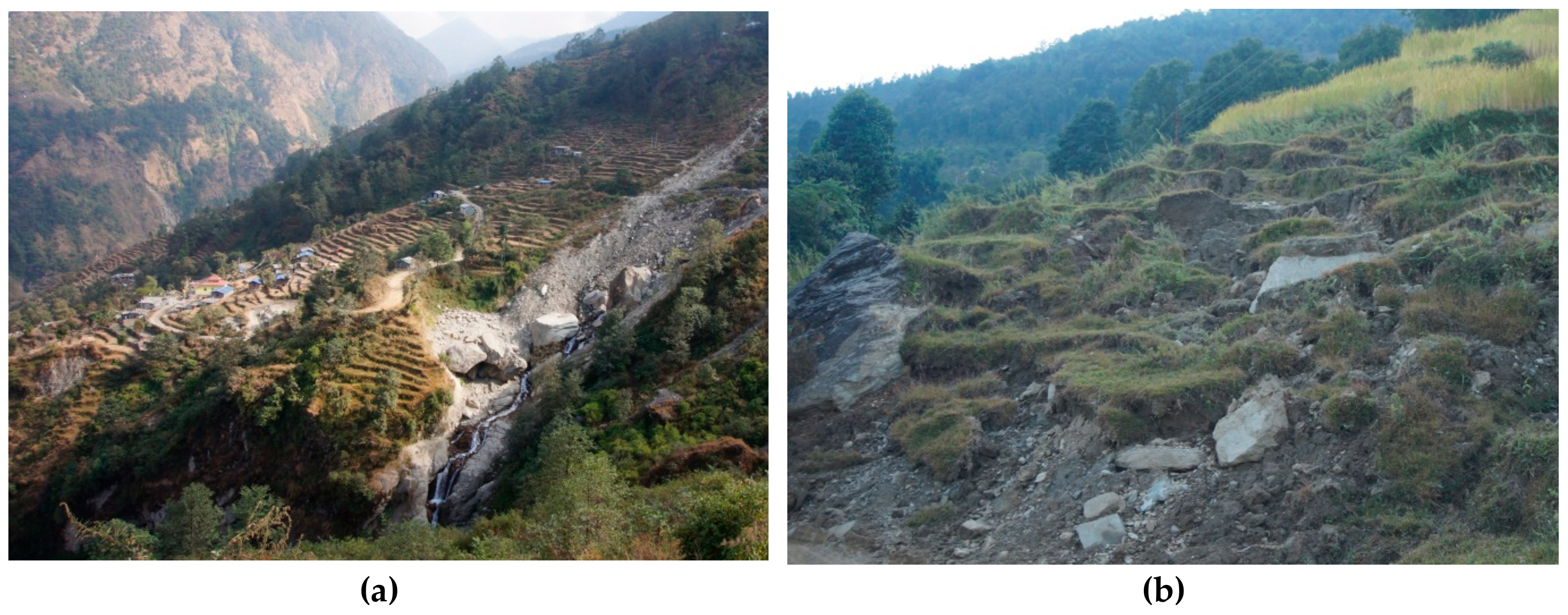
3.1. Assessment of Abandoned Farmland Spatiotemporal Degradation

Our survey in the Dordi river basin revealed that a minor proportion (8.5%) of abandoned farmlands were subject to earlier phases of damage (swelling). Terrace upsetting and bulging processes usually started within a year immediately after abandonment. Bulges appeared at any point in the terrace walls and ultimately resulted in division of the terraces into several sections. Approximately 19.5% of the terraces were affected by upsetting and 61% were under bulging processes, which further led to complete damage. Of the surveyed farmlands, 9% were already damaged completely, without any possibility of revival. Evidence for more frequent damage was present in south and east slope exposures relative to those facing north and west. Likewise, evidence for terraces bulging and collapsing was most common on hill slopes inclined between 31 and 40°. For altitudinal variation, farmlands are degraded at any location but are more commonly degraded between 800 and 1400 meters above the mean sea level (amsl). Areas in the provenance of the sandy rock of the Naudanda formation, which weathers into a loamy skeletal soil, demonstrate comparatively advanced progression of damage. Overall, the physical indicators of land degradation after abandonment of the farmlands are presented in Figure 3.

3.2. Identification of Major Causes of Degradation and Statistical Analysis

A multivariate regression statistical (MRS) model analysis was conducted to identify the significant causes of degradation of the abandoned farmlands in the Dordi river basin of Nepal. The result of the multivariate regression analysis is presented in Table 3. The different factors, such as the farmland elevation, age of abandonment, grazing, mining, annual precipitation, distance to road, distance to river/stream, distance to settlement, and distance to forest, were classified into four categories: biophysical, climate, socioeconomic activities, and neighborhood relations. These play significant roles in farmland degradation. In particular, grazing activities contribute positively and significantly (β = 0.677, þ = 0.000) to land degradation. Topographic slopes also have a significant influence, but contribute negatively to degradation (β = −0.142, þ = 0.100). Lithology (soil texture and geological condition) does not appear to affect degradation. Strangely, elevation and rainfall do not appear to have a significant effect. Socioeconomic activities such as mining and neighborhood relations (distance to forest, river/stream, settlement, and road) do not appear to have significant relationships in the real analysis, although their contributions at specific locations were high. Despite such relationships, the influence of socioeconomic activities on farmland degradation, even insignificant influences, are important for policy implications in the mountain regions, as revealed during the interaction with stakeholders, where such condition prevailed, albeit not everywhere. Obviously, the site specificity of such phenomena was diluted by the generalization inherent in the MRS.

3.3. Eco-Environmental Risks Associated with the Degradation of Abandoned Farmlands

There were mainly three types of eco-environmental hazards and consequent risks induced by degradation of abandoned farmlands in the Dordi river basin: (i) the most obvious type is landslides and the associated debris flows that form due to an abrupt collapse of toe support from slope terraces. (ii) A second type of hazard is gully formation and rock falls and progressive change, typified by weathering breakdown of soil or rock that initiates slope failure and the resultant losses. and (iii) the third type of hazard is soil erosion and sinkhole formation; these processes are slowly developing geomorphic hazards. The main eco-environmental risks associated with the three types of hazards are the degradation and loss of natural resources and the economic consequences. Other risks include damage to infrastructure, dwelling houses, and farmland crops, as well as domestic cattle. In this section, we discuss some of the features of the eco-environmental hazards and risks induced in areas of degradation of abandoned farmlands in the study area of the Dordi basin.

3.3.1. Landslides

Initiation and enlargement of landslides were observed along with degradation of abandoned farmlands in the Dordi river basin. We recorded 239 landslides that range in area from 5 to 200 m2. Most landslides are shallow, typically with a failure at the top few meters of the terraces’ surface. However, some of the slides were very large, up to 800 m2 long and deep seated. Some of slides were still active during our field study. We observed meter size angular boulders of crushed sandstone and mudstone falling. Eyewitnesses confirmed that most of the sliding processes were triggered by upsetting or collapsing of farmland terraces. These landslides were further aggravated by human interventions such as excavation at the slope toe, installation of drinking water pipelines along the unstable abandoned farmlands, redirecting of irrigation channels, and cattle grazing and mining activities. Landslides most often occurred during the monsoon seasons.
The landslides were found to be the most destructive and widely distributed mass movement along the abandoned terraces, downslope linearly. These landslides have increasingly wiped out large area of farmlands and forests and have blocked mountain infrastructure, roads, irrigation, and drinking water routes and have at several places even destroyed these routes. Farmers are interested in containing the impacts of farmland degradation, but maintenance of available farmland is beyond their control. Villagers often are unable to repair or redirect the damaged irrigation cannels due to lack of resources and technologies. Consequently, no serious initiatives have been taken to address the landslides initiated by farmland abandonment. While smaller landslides do little damage and can be easily rehabilitated by the farmers, the damages to the large number of infrastructures and the large debris deposition on adjacent farm plots caused by these larger landslides are beyond their capacities to handle. Conflicts were reported—a farmer, whose land is unaffected, does not want any interruption in the irrigation water supply and is not interested in any long-term solutions. Moreover, the lack of an organization that could solve the disagreements regarding the costs and responsibility for repairing damages exacerbates the problem. The local farmers wait for natural stabilization and then try to adapt the area for agricultural use, which is a long-term process, devoid of any local level policy and legislation support for mitigation and repair.

3.3.2. Debris Flows

Debris flows are another devastating environmental hazard that has been further accelerated by the degradation of abandoned farmlands. A total of 26 debris flow sites were mapped in the basin. The debris flow events were described by the locals as episodic, infrequent, and unpredictable. Most of the debris flows were small, with a scar width of approximately 5 m and a run-out of 10–20 m. However, some of the flows have a genetic long run out (100 m) of viscous fluid and the processes are catastrophic, and the events result in incised river channels, channel levees, and toe deposits that develop a lobate form similar to what has been described by Jakob [60]. Road construction that includes cutting hill slopes of abandoned farmlands have made the area more fragile and prone to violent debris flows.
Debris flow has been a major factor contributing to a variety of other environmental problems. The flows increase in volume by entrapping additional sediments, water, and organic debris, and deposit these materials in river channels and on downslope farmlands. Large quantities of debris flow lithospheric materials were seen trapped in adjacent infrastructure, e.g., irrigation canals, farmlands, and forests (Figure 4). These events threaten the safety of life and property. A debris flow that occurred in the village of Hiletaksar is an example. Two buildings, 30 m of irrigation canal, and approximately 65 huge trees were destroyed by this high energy debris flow in 2017. Twelve people were evacuated for a month, and 0.5 ha of cultivated farmland was washed away. Multiple ownership of the abandoned farmland has resulted in fragmentation of the terrace fields into smaller lots, which has increased the difficulty of management. Fortunately, there were no human casualties caused by this debris flow. Similarly, debris flows have increased the costs of replacement, rebuilding, repair, maintenance, and damaged property or installations. People have been forced to cross active debris flows in their daily life.

3.3.3. Gullies

Gully formations were one of the highly visible environmental processes due to degradation of abandonment farmlands. A gully referred to here is generally a narrow channel with deep incision on the slope by surface water flow. Mainly two types of gullies were found along the damaged terraces; (i) ephemeral gullies or junction of rills that form a dendritic pattern of channels, and (ii) bank gullies—removal of soil along the sides of the terrace’s walls by surface water runoff. Ephemeral gullies were usually up to 50 cm wide and 1 m deep and are of relatively small length (up to 3 m). Some of the gullies are very deep, up to 20 m long, and perpendicular to the terraces.
Apart from the natural processes, construction activities such as road, irrigation canals, and reservoir tanks have led to the initiation of gullies in the abandoned terraces. Some of the gullies appear to have expanded due to grazing activities. Some of them are so wide and large those inflict damage to the surrounding farmlands as well as to the nearby infrastructure such as roads, irrigation canals, and reservoirs, as well as have been a challenge to bring ploughs and farm machinery across. In such places, mosaic patterns of interspersed fallow and cultivated fields have developed. According to the farmers interviewed, such gully formation was high during the first years of farmland abandonment. They have also increased the need for labor workload to cultivate the land. Once started, they expand both vertically and laterally, and continue to move by head ward erosion in a feedback loop unless farmers put special effort to stabilize by implementing appropriate countermeasures. In the past, indigenous techniques such as stone bunds, terracing, and check dams were adopted for prevention and control of the gullies. However, these techniques are decreasing as many farmers have abandoned their fields in the long run.

3.3.4. Rock Falls

Rock falls were also widespread along the abandoned farmlands. While this phenomenon is less frequent than others, field observation recorded 57 rocks falls sites that resulted from the abandonment of farmland terraces. These sites include free falling, bouncing, and rolling of individual rocks and accumulation of gravel and boulder size rock pieces on the abandoned terraces. The sizes of rock, gravels, and boulders ranged from less than 1 m3 to over 50 m3. In some farmland, rock falls were reported extremely frequently. Most often, rock fall events were caused primarily by the losses of toe support to protect the farmland terraces. In addition, these events were caused or triggered by monsoon rainfall, vegetation succession along terraces, and the wedging effect due to roots of vegetation, vibrations from digging or blasting, grazing, and due to construction of infrastructure (e.g., roads, pipelines, electric poles, playgrounds, or irrigation canals).
Rock falls in the river basin result in blockages of roads or pedestrian footpaths, and damage to cultivated farmlands, forest, cowsheds, irrigation cannels, drinking water supply pipelines, and reservoir tanks (Figure 4). In such places, the boulders along the terraces also posed a threat to human lives, buildings, and animals. Fortunately, no rock fall event has led to either human injury or death to date. The farmers said that “for them, it is hard to shift rock or repair rock fall debris and the induced damages during and after every monsoon.” Moreover, rock falls remain a constant threat to mountain roadways, cowsheds, and settlements near the abandoned farmlands. Although rock falls are damaging and spectacular and attract public attention, most of the events were unreported. The precise assessment of rock fall risk, especially those induced by the abandonment of farmlands, has become a crucial issue for mountain settlers and local stakeholders.

3.3.5. Soil Erosion

Soil erosion in the Dordi basin is a grave environmental threat due to extensive abandonment of terraced farmlands. Approximately 60% of the surveyed abandoned farmlands were extensively degraded due to soil erosion. In addition, approximately 30% of observed abandoned farmland shows formation of active rills and gullies. Cases of accelerated erosion were easily observed on grazing areas, cropland, and/or road surfaces. Their effects can be easily observed both on site (nearby agricultural farmland), and off site (siltation on river stream, ponds, reservoir tanks, irrigation canals, and roads) downstream in the river basin.
Unlike landslides and debris flows, soil erosion is not considered to be a risk, because it does not pose a direct and immediate danger. However, erosional processes have induced or stimulated different hazardous phenomenon such as (i) rock falls or gully erosion—runoffs from a neighbouring abandoned farmland get channeled into the gullies and or exceeding the capacities of the gullies. As a result, the smaller gullies widen turning into a larger streamlet called a “Kholso”. In such cases, such large gullies become susceptible to landslides. (ii) Reduction in areas for cattle grazing (which leads to serious consequences for local animal husbandry). (iii) Increased sedimentation in downstream rivers, streams, and lakes as well as on infrastructural facilities such as roads, canals, and reservoirs that are being constructed. These conditions are evident. In addition, the deep, fertile, and ancient soils that supported the farmlands are being washed away. The farmlands that were fertile can no longer be cultivated. Therefore, these observations demand the adoption of suitable land uses for the abandoned farmlands to protect the invaluable productive natural resources.

3.3.6. Sinkholes

Sinkholes are another threatening hazard due to the degradation of abandoned farmlands. Mainly two types of sinkholes, namely, (i) solution sinkholes and (ii) cover subsidence sinkholes, were observed in the abandoned farmlands. The formations of all of these holes appear to be in an erratic pattern. They were usually bowl shaped and relatively small in average sizes (2 m deep, 1–2 m wide). The sinkholes resulted from both artificial and natural causes. Primarily, solution sinkholes were developed through the draining of surficial soil by water and or rock fall processes. In addition, the cover subsidence sinkholes were found to derive from human activities, i.e., distribution of irrigation canals along the terraces, reservoir tanks, and digging activities. Villages such as Basnetgaun and Syaud areas were mainly affected by cover subsistence sinkholes.
Overall, sinkholes along the abandoned terraces develop slowly without any spectacular event. However, they can pose extensive risk for the terrace surface when a large number of sinkholes collapse. In such places, water supply pipelines break, thereby gushing water into the holes. The surface turns into a honeycomb shape, and a part of the farmland is destroyed. Irrigational canals that cross the abandoned farmlands get disrupted, and such collapses seriously restrict cattle grazing.

4. Discussion

Terrace surface swelling, upsetting, bulging, and collapse were the four indicators used to assess the present-day condition of the abandoned farmlands. Historical records show that past mountain farmers in river basins in Nepal transformed the high slope amplitudes (by cutting slopes or filling of lands) into terraced farmland to gain a larger surface area for cultivation on hill slopes and to support long-term water irrigation [2]. The practice of erecting 1–4 m high inter-terrace retaining walls using earth and boulders of different sizes available locally is also a practice in the mountain region of Nepal [61]. These kinds of farmland activities are seen as a human interference to the hydro-geomorphic system of hilly and mountainous landscapes [62,63]. In particular, terracing of the farmland impacts specific changes on the slope of the land surface, reorients the rainfall runoff flow, and stabilizes soil layers that govern the dynamic features of the earth surface. Stone walls help to alternate varying profiles of the terrain and to gain subhorizontal surfaces along the mountain slope. Therefore, with any cessation of land management activities or abandonment of terraced farmland slope surfaces, the natural geomorphic processes try to gain control over the hill slope and accelerate the land degradation, resulting in swelling, upsetting, bulges, and damage to the abandoned farmland landscape in Nepal.
The results demonstrate that prevalent grazing, slope gradient, and construction of hill roads contributes positively and significantly to the failure of abandoned terraces. This result seems reasonable for conditions in Nepal. In reality, more than 80% of the households in the study area are found to have at least one pair of oxen, one cow, and or buffalo in the family. These livestock are reared mainly for farming activities, as well as for milk, meat, and foraging [31]. However, the method of rearing livestock is problematic. Farmlands after abandonment in Nepal are viewed as open-for-all property resources and quickly start being used for animal grazing [11]. The processes of grazing lead to gradual deterioration of the terrace surfaces, which leads to the collapse of terraces and the walls [64]. This is due to (i) compaction of soil, (ii) pulverization or reduction of top fertile soil, (iii) fracturing and descaling of terrace walls. Compaction or hard setting of soil mainly eliminates or reduces the structural pores of soils and thus prevents natural vegetation succession on terrace surfaces. Pulverization mainly occurs in the detachment of small portions of materials (chips) from the originally intact elements, which can lose stability and become prone to erosion in the long term. Fracturing or descaling often accelerates run-off and erosion, followed by resulting small slope movements and gullying on the terraces. These processes initiate and rapidly accelerate farmland degradation.
High slope gradient is another important variable for the degradation of abandoned farmlands. Most of the mountain farmlands (approximately 70%) in Nepal are located on steep hill slopes inclined at 25–35° [36]. As a consequence, erosion and runoff were increased greatly after the land abandonment [65]. The distribution of runoff and erosion was directly related to the spatial distribution of the vegetation. Whereas, vegetation cover was minimal immediately following farmland abandonment, and subsequently the spatial variability increased after abandonment [11]. Once the field was abandoned, surface runoff and sediment concentration was increased by 2.1 and 1.2 times, respectively [66]. Agriculture farmland abandonment resulted in lower erosion rates over the long term, but showed an increase in soil and water losses over the short term [67]. Likewise, as the hill slope becomes steeper, the terrace becomes narrower, and the height of the terrace wall increases. A taller terrace wall has a greater chance of collapse and requires more maintenance, which is more difficult where the terrace is narrow [68]. In addition, a narrow terrace prevents the use of machinery or animal power and farmers have to use locally made hand-held agricultural tools appropriate to the narrow terraces, which sometimes are as narrow as 1 m wide. Farmers need to walk up and down the hill slopes herding the cattle and carrying the tools, bags of seed, seedlings, manure, fertilizers, and the harvest on their backs. The time required to move a machine up and down a terrace increases as the slope inclination increases, which increases the labor demands. These factors increase the stress on the abandoned farmlands located on steep slopes.
Construction of hill roads also contributes to the degradation of abandoned farmland. In fact, after the peace process of 2006, the construction of feeder and rural access roads greatly increased [69]. While road construction has helped the accessibility of mountain communities in Nepal, it has created numerous environmental problems mainly due to the lack of technical know-how, the construction machinery, and lack of regulations. As road construction is difficult on steep slopes, the road is often aligned along agricultural terraces and the abandoned terraces are “attractive” terrain on which to place the road. Due to lack of good engineering practices, the road formation is excavated into the hill and the cut-materials are dumped downslope and then roll down and bury the agricultural terraces below. This disturbs the natural regime of the terrain. Furthermore, the removal of soil and stones from the slopes and stream banks causes severe disruption of the geomorphic regime and accelerates more failures, especially on the slopes above the road. Roads constructions also disrupt existing water courses, either by channeling the runoff down the road or by diverting it from smaller channels to the overburdened larger streams. Similarly, the advent of earth-moving machinery has enhanced road construction in cuts and the disposal of the cut materials downslope without any consideration of ecological sensitivity. Stormwater is often diverted from the road to the loose fill. Thus, the newly built roads usually interrupt the slope gradient and contribute to damage of farmlands immediately above and below them.
Additionally, (i) successions of plants and/or the high rate of infiltration on terrace beds are other causes of terrace damage after abandonment [22]. The unwanted growth of shrubs or plants results in several scars on the stone walls or earth dams that speed their decay and ultimate failure. The developing roots increasingly exert pressure on the loose stones, which also leads to terrace wall upsetting, bulges, and/or collapses. (ii) Surface runoff after abandonment saturates the inner parts of the terraces and the accumulated soil is deposited behind the stone walls. This deposit increases stress on the wall materials, which contributes to the terrace-wall shearing off. A bulge can appear at any point of the wall and divide the terraces into several sections. The final result is the continual increase in the bulging of the terraces and their ultimate collapse. These processes leave the terraces completely unprotected and bare. Most often, these changes to terrace surfaces coincide with different problems of instability in the steps between the terraces.
Moreover, more than 90% of homes in the mountains of Nepal are built in stone with mud mortar and red clay is widely used for painting and decorating the houses; therefore, people are heavily dependent upon raw construction materials such as clay soils, sand, stone blocks, and gravels. Therefore, mining for boulders and soil digging is a necessity. Abandoned farmlands are very attractive for mining and sourcing stone blocks or digging soil. These activities increase infiltration and concentrate channelization of surface runoff. Additionally, these mining and digging areas are frequently connected by various road networks that have their own effects on water sources and change the flow paths, resulting in an increased rate of overland flow, erosion, and mass wasting similar to what has been observed along forest roads [62] and in other areas of mountainous Nepal.

5. Conclusions

This study focused on the extent of spatiotemporal degradation and the causes and effects of farmland abandonment in the Himalayan mountains and revealed a grave situation, i.e., 92% of the abandoned farmlands are degraded at different levels: nearly one-tenth of these farmlands are damaged completely and irrevocably, more than half are damaged at an advanced level (bulge), and one-fifth of the abandoned farmlands suffer from upsetting and the initial stages of damage. The resulting degradation has triggered numerous new or intensified geomorphic hazards such as landslides, debris flows, gully erosion, rock falls, and sinkhole development. These hazards pose a serious threat to the placement and exploitation of development infrastructure such as hill roads, irrigation structures, water supply, and electricity systems. Furthermore, farmland abandonment degradation not only creates safety issues and difficulties for agriculture, but also has a long-term impact on ecological resources and biodiversity. Such an alarming situation warrants urgent mitigation activities to arrest the ever-increasing trend of degradation and to stop and reduce the decline in erstwhile productive farmlands, perhaps by introducing changes in land use. Moreover, this demands an understanding of the cause–effect relationship between farmland degradation and abandonment, including the costs of the potential risks; these features should be included in social and economic development planning to ensure mountainous livelihood, food security, and landscape sustainability.
Due to the similarity of livelihoods and physiographic conditions throughout the mountains of Nepal, it is axiomatic that the processes and the extent of land degradation due to farmland abandonment is prolific nationwide and the cause–effect relationship would be common throughout the country, with secondary variations due to site and regional specificity. While topographic factors such as elevation, relief and hill slope, inclination, rainfall amount and intensities are background parameters that influence the extent and rate of degradation, socioeconomic factors such as the distances of the farmlands to settlements, forests, roads and rivers, soil/rock mining and grazing were exacerbating factors for farmland degradation. The multivariate analysis revealed that traditional practices of cattle grazing had the most significant influences on farmland degradation. However, the multivariate analysis could not adequately capture the relative importance of the detrimental influence of the construction of roads and irrigation canals in and across the degrading abandoned farmlands. Their significant role in accelerating the degradational processes was conspicuously seen at specific sites during the field survey. In addition, in the near future, the construction processes will intensify as the development of authority granted by the federalization of governance firmly takes ground in Nepal. Thus, these relationships indicate an urgent need to enforce better land management practices through improvement in the policy and legal environment, including the enunciation of effective land use policies that include amendments of existing ownership, rights of use, and taxation; the effective implementation of such policies would demand strong technical support systems at the farm, household, village, and institutional levels.
Finally, based upon the above conclusions, we recommend the following priority actions are taken: (i) implement pilot research on management of degradation due to farmland abandonment, (ii) develop and implement a national programme for restoration of abandoned farmlands, and (iii) capacity building programme, and (iv) institutionalization with a clear strategy to assess and analyze related biophysical and socioeconomic baseline parameters, enhance local capacities and implementation of concrete mitigation measures on an experimental basis. Large-scale studies integrating remote sensing data and geographic information systems are needed to investigate in detail the degradation process and risk eco-environmental risk status of the entire mountain chain in Nepal. For management purposes, an adaptation of commercial farming, such as commercial dairy farming, with a substantial increase in fodder trees, off-season vegetable farming, fruit farming, tea cultivation, agroforestry, etc., could be used for preservation of degraded traditional agricultural terraced landscapes. Policies to mitigate farmland degradation have to prioritize practices with low impact on vegetation cover and promote soil protection practices such as tree cover planting and mulching.

Author Contributions

Conceptualization, S.C.; methodology, S.C.; software, S.C., K.Y., Q.L., Y.L., and M.L, validation, S.C.; formal analysis, S.C.; investigation, S.C.; resources, Y.W., and P.X.; data curation, S.C.; writing-original draft preparation, S.C.; writing review and editing, Y.W., A.M.D., N.R.K., P.X., and B.F.; visualization, K.Y., Q.L., Y.L., and M.L.; project administration, Y.K., P.X., and B.F.; funding acquisition, Y.K., P.X., and B.F.

Funding

This research was supported by the 135 strategic program of the Institute of Mountain Hazards and Environment, Chinese Academy of Science, grant number SDS – 135 - 1703; International talent program of the Chinese Academy of the Sciences, grant number 2019 VCA 0026); and the Chinese Academy of Sciences-the World Academy of Sciences (CAS-TWAS) Presidents Fellowship program for international PhD study.

Acknowledgments

We are extremely grateful to the Central Department of Geography (CDG) and the National Society for Earthquake Technology (NSET) for sharing their valuable dataset and for review of the manuscript. The authors were grateful for any constructive comments from the editor and anonymous reviewers.

Conflicts of Interest

Authors declare no conflict of interest.

References

  1. Agnoletti, M.; Errico, A.; Santoro, A.; Dani, A.; Preti, F. Terraced Landscapes and Hydrogeological Risk. Effects of Land Abandonment in Cinque Terre (Italy) during Severe Rainfall Events. Sustainability 2019, 11, 235. [Google Scholar] [CrossRef] [Green Version]
  2. Paudel, G.S.; Thapa, G.B. Changing farmers’ land management practices in the hills of Nepal. Environ. Manag. 2001, 28, 789–803. [Google Scholar] [CrossRef] [PubMed]
  3. Bakker, M.; Veldkamp, A. Changing relationships between land use and environmental characteristics and their consequences for spatially explicit land-use change prediction. J. Land Use Sci. 2012, 7, 407–424. [Google Scholar] [CrossRef]
  4. Latocha, A. Land-use changes and longer-term human–environment interactions in a mountain region (Sudetes Mountains, Poland). Geomorphology 2009, 108, 48–57. [Google Scholar] [CrossRef]
  5. Huber, R.; Rigling, A.; Bebi, P.; Brand, F.S.; Briner, S.; Buttler, A.; Elkin, C.; Gillet, F.; Grêt-Regamey, A.; Hirschi, C. Sustainable land use in mountain regions under global change: Synthesis across scales and disciplines. Ecol. Soc. 2013, 18, 36. [Google Scholar] [CrossRef] [Green Version]
  6. Awasthi, K.; Sitaula, B.; Singh, B.; Bajacharaya, R. Land-use change in two Nepalese watersheds: GIS and geomorphometric analysis. Land Degrad. Dev. 2002, 13, 495–513. [Google Scholar] [CrossRef]
  7. Anache, J.A.; Flanagan, D.C.; Srivastava, A.; Wendland, E.C. Land use and climate change impacts on runoff and soil erosion at the hillslope scale in the Brazilian Cerrado. Sci. Total Environ. 2018, 622, 140–151. [Google Scholar] [CrossRef]
  8. Deng, J.S.; Wang, K.; Hong, Y.; Qi, J.G. Spatio-temporal dynamics and evolution of land use change and landscape pattern in response to rapid urbanization. Landsc. Urban Plan. 2009, 92, 187–198. [Google Scholar] [CrossRef]
  9. Jaquet, S.; Shrestha, G.; Kohler, T.; Schwilch, G. The Effects of Migration on Livelihoods, Land Management, and Vulnerability to Natural Disasters in the Harpan Watershed in Western Nepal. Mt. Res. Dev. 2016, 36, 12. [Google Scholar] [CrossRef] [Green Version]
  10. Contessa, V. Terraced Landscapes in Italy: State of the Art and Future Challenges. Master’s Thesis, University of Padova, Padova, Italy, 2014. [Google Scholar]
  11. Chaudhary, S.; Wang, Y.; Khanal, N.; Xu, P.; Fu, B.; Dixit, A.; Yan, K.; Liu, Q.; Lu, Y. Social Impact of Farmland Abandonment and Its Eco-Environmental Vulnerability in the High Mountain Region of Nepal: A Case Study of Dordi River Basin. Sustainability 2018, 10, 2331. [Google Scholar] [CrossRef] [Green Version]
  12. Campbell, J.E.; Lobell, D.B.; Genova, R.C.; Field, C.B. The global potential of bioenergy on abandoned agriculture lands. Environ. Sci. Technol. 2008, 42, 5791–5794. [Google Scholar] [CrossRef] [PubMed]
  13. Gellrich, M.; Baur, P.; Koch, B.; Zimmermann, N.E. Agricultural land abandonment and natural forest re-growth in the Swiss mountains: A spatially explicit economic analysis. Agric. Ecosyst. Environ. 2007, 118, 93–108. [Google Scholar] [CrossRef]
  14. García-Ruiz, J.M.; Lana-Renault, N. Hydrological and erosive consequences of farmland abandonment in Europe, with special reference to the Mediterranean region—A review. Agric. Ecosyst. Environ. 2011, 140, 317–338. [Google Scholar] [CrossRef]
  15. Antrop, M. The concept of traditional landscapes as a base for landscape evaluation and planning. The example of Flanders Region. Landsc. Urban Plan. 1997, 38, 105–117. [Google Scholar] [CrossRef]
  16. CBS. Environment Statistics of Nepal 2019; Government of Nepal (GoN), National Planning Commission, Central Bureau of Statistics: Thapathali, Nepal, 2019.
  17. Keesstra, S.D.; Bouma, J.; Wallinga, J.; Tittonell, P.; Smith, P.; Cerdà, A.; Montanarella, L.; Quinton, J.N.; Pachepsky, Y.; van der Putten, W.H.; et al. The significance of soils and soil science towards realization of the United Nations Sustainable Development Goals. SOIL 2016, 2, 111–128. [Google Scholar] [CrossRef] [Green Version]
  18. Merrey, D.J.; Drechsel, P.; de Vries, F.P.; Sally, H. Integrating “livelihoods” into integrated water resources management: Taking the integration paradigm to its logical next step for developing countries. Reg. Environ. Chang. 2005, 5, 197–204. [Google Scholar] [CrossRef]
  19. Benayas, J.R.; Martins, A.; Nicolau, J.M.; Schulz, J.J. Abandonment of agricultural land: An overview of drivers and consequences. CAB Rev. Perspect. Agric. Vet. Sci. Nutr. Nat. Resour. 2007, 2, 1–14. [Google Scholar] [CrossRef] [Green Version]
  20. Keenleyside, C.; Tucker, G.; McConville, A. Farmland Abandonment in the EU: An Assessment of Trends and Prospects; Institute for European Environmental Policy: London, UK, 2010. [Google Scholar]
  21. MacDonald, D.; Crabtree, J.; Wiesinger, G.; Dax, T.; Stamou, N.; Fleury, P.; Lazpita, J.G.; Gibon, A. Agricultural abandonment in mountain areas of Europe: Environmental consequences and policy response. J. Environ. Manag. 2000, 59, 47–69. [Google Scholar] [CrossRef]
  22. Sirami, C.; Brotons, L.; Martin, J.L. Vegetation and songbird response to land abandonment: From landscape to census plot. Divers. Distrib. 2007, 13, 42–52. [Google Scholar] [CrossRef]
  23. Suárez-Seoane, S.; Osborne, P.E.; Baudry, J. Responses of birds of different biogeographic origins and habitat requirements to agricultural land abandonment in northern Spain. Biol. Conserv. 2002, 105, 333–344. [Google Scholar] [CrossRef]
  24. Cerdà, A.; Morera, A.G.; Orenes, F.G.; Morugán, A.; Pelayo, O.G.; Pereira, P.; Novara, A.; Brevik, E. The impact of abandonment of traditional flood irrigated citrus orchards on soil infiltration and organic matter. In Geoecología, Cambio Ambiental y Paisaje: Homenaje al Profesor José María García Ruiz; Instituto Pirenaico de Ecología: Zaragoza, Spain, 2014; pp. 267–276. [Google Scholar]
  25. Van der Wal, A.; van Veen, J.A.; Smant, W.; Boschker, H.T.; Bloem, J.; Kardol, P.; van der Putten, W.H.; de Boer, W. Fungal biomass development in a chronosequence of land abandonment. Soil Biol. Biochem. 2006, 38, 51–60. [Google Scholar] [CrossRef]
  26. Nainggolan, D.; de Vente, J.; Boix-Fayos, C.; Termansen, M.; Hubacek, K.; Reed, M.S. Afforestation, agricultural abandonment and intensification: Competing trajectories in semi-arid Mediterranean agro-ecosystems. Agric. Ecosyst. Environ. 2012, 159, 90–104. [Google Scholar] [CrossRef]
  27. Hobbs, R.J.; McIntyre, S. Categorizing Australian landscapes as an aid to assessing the generality of landscape management guidelines. Glob. Ecol. Biogeogr. 2005, 14, 1–15. [Google Scholar] [CrossRef]
  28. Dong, S.; Lassoie, J.; Yan, Z.; Sharma, E.; Shrestha, K.; Pariya, D. Indigenous rangeland resource management in the mountainous areas of northern Nepal: A case study from the Rasuwa District. Rangel. J. 2007, 29, 149–160. [Google Scholar] [CrossRef]
  29. Ojha, H.R.; Shrestha, K.K.; Subedi, Y.R.; Shah, R.; Nuberg, I.; Heyojoo, B.; Cedamon, E.; Rigg, J.; Tamang, S.; Paudel, K.P. Agricultural land underutilisation in the hills of Nepal: Investigating socio-environmental pathways of change. J. Rural Stud. 2017, 53, 156–172. [Google Scholar] [CrossRef]
  30. Schwilch, G.; Adhikari, A.; Jaboyedoff, M.; Jaquet, S.; Kaenzig, R.; Liniger, H.; Penna, I.M.; Sudmeier-Rieux, K.; Upreti, B.R. Impacts of outmigration on land management in a Nepali mountain area. In Identifying Emerging Issues in Disaster Risk Reduction, Migration, Climate Change and Sustainable Development; Springer: Cham, Switzerland, 2017; pp. 177–194. [Google Scholar]
  31. Central Bureau of Statistics (CBS). National Population and Housing Census 2011; National Report; Central Bureau of Statistics (CBS), Government of Nepal: Kathmandu, Nepal, 2012.
  32. Bishop, M.P.; Shroder, J.F., Jr.; Bonk, R.; Olsenholler, J. Geomorphic change in high mountains: A western Himalayan perspective. Glob. Planet. Chang. 2002, 32, 311–329. [Google Scholar] [CrossRef]
  33. MoAD. Statistical Information on Nepalese Agriculture 2015/16; Minstry of Agriculture and Development (MoAD), Government of Nepal: Kathmandu, Nepal, 2016.
  34. Paudel, K.P.; Tamang, S.; Shrestha, K.K. Transforming land and livelihood: Analysis of agricultural land abandonment in the Mid Hills of Nepal. J. For. Livelihood 2014, 12, 11–19. [Google Scholar]
  35. Khanal, N.; Watanabe, T. Abandonment of Agricultural Land and Its Consequences: A Case Study in the Sikles Area, Gandaki Basin, Nepal Himalaya. Mt. Res. Dev. 2006, 26, 32–40. [Google Scholar] [CrossRef] [Green Version]
  36. LRMP. Land Capability Map; Land Resource Mapping Project: Kathmandu, Nepal, 1986. [Google Scholar]
  37. Slaymaker, O.; Owens, P.N. Mountain geomorphology and global environmental change. In Mountain Geomorphology; Cambridge University Press: Cambridge, UK, 2004; pp. 277–300. [Google Scholar]
  38. Long, H.; Tang, G.; Li, X.; Heilig, G.K. Socio-economic driving forces of land-use change in Kunshan, the Yangtze River Delta economic area of China. J. Environ. Manag. 2007, 83, 351–364. [Google Scholar] [CrossRef]
  39. Mottet, A.; Ladet, S.; Coqué, N.; Gibon, A. Agricultural land-use change and its drivers in mountain landscapes: A case study in the Pyrenees. Agric. Ecosyst. Environ. 2006, 114, 296–310. [Google Scholar] [CrossRef]
  40. Lasanta, T.; Arnáez, J.; Pascual, N.; Ruiz-Flaño, P.; Errea, M.; Lana-Renault, N. Space–time process and drivers of land abandonment in Europe. Catena 2017, 149, 810–823. [Google Scholar] [CrossRef]
  41. Cramer, V.A.; Hobbs, R.J.; Standish, R.J. What’s new about old fields? Land abandonment and ecosystem assembly. Trends Ecol. Evol. 2008, 23, 104–112. [Google Scholar] [CrossRef] [PubMed]
  42. Koutsias, N.; Xanthopoulos, G.; Founda, D.; Xystrakis, F.; Nioti, F.; Pleniou, M.; Mallinis, G.; Arianoutsou, M. On the relationships between forest fires and weather conditions in Greece from long-term national observations (1894–2010). Int. J. Wildland Fire 2013, 22, 493–507. [Google Scholar] [CrossRef] [Green Version]
  43. Marston, R.A.; Miller, M.M.; Devkota, L.P. Geoecology and mass movement in the Manaslu-Ganesh and Langtang-Jugal himals, Nepal. Geomorphology 1998, 26, 139–150. [Google Scholar] [CrossRef]
  44. Barnard, P.L.; Owen, L.A.; Sharma, M.C.; Finkel, R.C. Natural and human-induced landsliding in the Garhwal Himalaya of northern India. Geomorphology 2001, 40, 21–35. [Google Scholar] [CrossRef]
  45. Devkota, K.C.; Regmi, A.D.; Pourghasemi, H.R.; Yoshida, K.; Pradhan, B.; Ryu, I.C.; Dhital, M.R.; Althuwaynee, O.F. Landslide susceptibility mapping using certainty factor, index of entropy and logistic regression models in GIS and their comparison at Mugling–Narayanghat road section in Nepal Himalaya. Nat. Hazards 2013, 65, 135–165. [Google Scholar] [CrossRef]
  46. Cao, Y.; Wu, Y.; Zhang, Y.; Tian, J. Landscape pattern and sustainability of a 1300-year-old agricultural landscape in subtropical mountain areas, Southwestern China. Int. J. Sustain. Dev. World Ecol. 2013, 20, 349–357. [Google Scholar] [CrossRef]
  47. Menard, S. Six approaches to calculating standardized logistic regression coefficients. Am. Stat. 2004, 58, 218–223. [Google Scholar] [CrossRef]
  48. Kienholz, H.; Hafner, H.; Schneider, G.; Tamrakar, R. Mountain Hazards Mapping in Nepal’s Middle Mountains Maps of Land Use and Geomorphic Damages (Kathmandu-Kakani Area). Mt. Res. Dev. 1983, 3, 195–220. [Google Scholar] [CrossRef]
  49. Gardner, J.S.; Saczuk, E. Systems for hazards identification in high mountain areas: An example from the Kullu District, Western Himalaya. J. Mt. Sci. 2004, 1, 115. [Google Scholar] [CrossRef]
  50. Gardner, J.; DeScally, F.; Rowbatham, D. Identification and monitoring of multiple geomorphic hazards in high mountain areas. In Dynamics of Mountain Geosystems; Ashish Publications: New Delhi, India, 1992; pp. 247–270. [Google Scholar]
  51. Gatsis, I.; Pavlopoulos, A.; Parcharidis, I. Geomorphological observations and related natural hazards using merged remotely sensed data: A case study in the Corinthos area (NE Peloponnese, S. Greece). Geogr. Ann. Ser. A Phys. Geogr. 2001, 83, 217–228. [Google Scholar] [CrossRef]
  52. Hewitt, K. Mountain hazards. GeoJournal 1992, 27, 47–60. [Google Scholar] [CrossRef]
  53. Glade, T. Landslide occurrence as a response to land use change: A review of evidence from New Zealand. Catena 2003, 51, 297–314. [Google Scholar] [CrossRef] [Green Version]
  54. Garcıa-Ruiz, J.; Arnáez, J.; Beguerıa, S.; Seeger, M.; Martı-Bono, C.; Regüés, D.; Lana-Renault, N.; White, S. Runoff generation in an intensively disturbed, abandoned farmland catchment, Central Spanish Pyrenees. Catena 2005, 59, 79–92. [Google Scholar] [CrossRef] [Green Version]
  55. Hambrey, M.J.; Quincey, D.J.; Glasser, N.F.; Reynolds, J.M.; Richardson, S.J.; Clemmens, S. Sedimentological, geomorphological and dynamic context of debris-mantled glaciers, Mount Everest (Sagarmatha) region, Nepal. Quat. Sci. Rev. 2008, 27, 2361–2389. [Google Scholar] [CrossRef]
  56. Poesen, J. Gully typology and gully control measures in the European loess belt. In Proceedings of the International Symposium on Farm Land Erosion in Temperate Plains Environments and Hills, Saint-Cloud, Paris, France, 1 May 1993; pp. 221–239. [Google Scholar]
  57. Morgan, R.; Quinton, J.; Smith, R.; Govers, G.; Poesen, J.; Auerswald, K.; Chisci, G.; Torri, D.; Styczen, M. The European Soil Erosion Model (EUROSEM): A dynamic approach for predicting sediment transport from fields and small catchments. Earth Surf. Process. Landf. 1998, 23, 527–544. [Google Scholar] [CrossRef]
  58. Peng, T.; Wang, S.-J. Effects of land use, land cover and rainfall regimes on the surface runoff and soil loss on karst slopes in southwest China. Catena 2012, 90, 53–62. [Google Scholar] [CrossRef]
  59. Gerba, C.P. Risk assessment. In Environmental and Pollution Science; Elsevier/Academic Press: Burlington, Vermont, 2019; pp. 541–563. [Google Scholar]
  60. Jakob, M. A size classification for debris flows. Eng. Geol. 2005, 79, 151–161. [Google Scholar] [CrossRef]
  61. Thapa, G.; Paudel, G. Farmland degradation in the mountains of Nepal: A study of watersheds ‘with’and ‘without’external intervention. Land Degrad. Dev. 2002, 13, 479–493. [Google Scholar] [CrossRef]
  62. Tarolli, P.; Preti, F.; Romano, N. Terraced landscapes: From an old best practice to a potential hazard for soil degradation due to land abandonment. Anthropocene 2014, 6, 10–25. [Google Scholar] [CrossRef]
  63. Lasanta, T.; Garcıa-Ruiz, J.; Pérez-Rontomé, C.; Sancho-Marcén, C. Runoff and sediment yield in a semi-arid environment: The effect of land management after farmland abandonment. Catena 2000, 38, 265–278. [Google Scholar] [CrossRef] [Green Version]
  64. Leal Filho, W.; Mandel, M.; Al-Amin, A.Q.; Feher, A.; Chiappetta Jabbour, C.J. An assessment of the causes and consequences of agricultural land abandonment in Europe. Int. J. Sustain. Dev. World Ecol. 2017, 24, 554–560. [Google Scholar] [CrossRef] [Green Version]
  65. Cerda, A. Soil erosion after land abondonment in a semiarid environment of southeastern Spain. Arid Soil Res. Rehabil. 1997, 11, 163–176. [Google Scholar] [CrossRef]
  66. Cerda, A.; Rodrigo-Comino, J.; Novara, A.; Brevik, E.C.; Vaez, A.R.; Pulido, M.; Gimenez-Morera, A.; Keesstra, S.D. Long-term impact of rainfed agricultural land abandonment on soil erosion in the Western Mediterranean basin. Prog. Phys. Geogr. 2018, 1, 18. [Google Scholar]
  67. Cerdà, A.; Ackermann, O.; Terol, E.; Rodrigo-Comino, J. Impact of Farmland Abondonment on Water Resources and Soil Conservation in Citrus Plantations in Eastern Spain. Water 2019, 11, 15. [Google Scholar] [CrossRef] [Green Version]
  68. Stavi, I.; Rozenberg, T.; Al-Ashhab, A.; Argaman, E.; Groner, E. Failure and collapse of ancient agricultural stone terraces: On-Site effects on soil and vegetation. Water 2018, 10, 1400. [Google Scholar] [CrossRef] [Green Version]
  69. Campbell, B. Rhetorical routes for development: A road project in Nepal. Contemp. South Asia 2010, 18, 267–279. [Google Scholar] [CrossRef]
Figure 1. Location of the study area.
Land 09 00001 g001
Figure 2. Abandoned farmland characterizing several conditions on terraces: (a) swelling on surfaces, (b) upsetting of terraces, (c) bulges on terraces, (d) collapsed terraces.
Land 09 00001 g002
Figure 3. Farmland degradation normalized for (a) the time interval since abandonment, (b) the slope aspect, (c) the slope gradient, and (d) the altitudinal variation.
Land 09 00001 g003
Figure 4. Abandoned farmland surface process underlying eco-environmental risks: (a) rock falls including gravels and boulders and (b) debris slides damaging cultivated farmlands.
Land 09 00001 g004
Table 1. Data sources and their units.
CategoriesDataUnitSources
BiophysicalElevationMetersField Survey, GPS
SlopeDegreesDigital elevation model (DEM), USGS
SoilTypeLand Resource Mapping Project (LRMP) of Nepal,1986
SocioeconomicAge of abandonmentYearField Survey
GrazingY/NField Survey
Mining/soil diggingY/NField Survey
ClimateAnnual precipitationMillimeters (mm)Department of Hydrology and Meteorology (DHM), Nepal Government
NeighborhoodDistance to roadMetersDepartment of Survey (DoS), Nepal Government
Distance to river/streamMetersDepartment of Survey (DoS), Nepal Government
Distance to settlementMetersDepartment of Survey (DoS), Nepal Government
Distance to forestMetersDepartment of Survey (DoS), Nepal Government
Table 2. Selected variables, explanatory definition, and expected role in farmland degradation.
VariablesExplanatory DefinitionExpected Relationship to Farmland Degradation
A. Biophysical
ElevationMean altitude recorded by GPS (meters)Farmlands located at higher elevations are more likely to have a terrace failure
SlopeMean slope degrees (21–30° = 1, 31–40° = 2, 41–50° = 3) Farmlands with higher gradient are more likely to have a terrace failure
B. Socioeconomic
Age of abandonmentFarmland since abandonment (years)Farmlands with a long period of abandonment are likely to have damage
GrazingGrazing activities (yes = 1, no = 2)Farmlands with grazing activities are more likely to have damage
Mining and soil diggingMining/digging activities (yes = 1, no = 2)Farmlands with mining/soil digging activities are more likely to be degraded
C. Climate
Annual precipitationMean precipitation (millimeters)Variation in rainfall pattern may have diverse pattern of land degradation
D. Neighborhood
Distance to roadMean distance to vehicle passable road (meters)Farmlands located closer to roads are more likely to have terrace failure
Distance to river/streamMean distance to major river/stream (meters)Farmlands located closer to river/streams are more likely to have terrace failure
Distance to settlementMean distance to major settlement (meters)Farmlands located close to settlements are more likely to have grazing and therefore terrace failure
Distance to forestMean distance to nearby forest (meters)Farmlands located closer to forests are more likely to have terrace failure
Table 3. Farmland properties and their contribution to farmland degradation.
CategoriesVariablesBeta (β)Standard Error (SE)Significance (þ)
BiophysicalElevation (meters)−0.1710.0000.195
Slope (degrees)−0.1420.0360.100***
ClimateRainfall (millimeters)−0.1580.0300.300
SocioeconomicAge of abandonment (years)−0.0050.0030.943
Grazing activities0.6770.0570.000*
Mining/digging−0.0010.0870.987
NeighborhoodDistance to river/stream (metre)0.0750.0000.454
Distance to settlement (meters)0.0460.0000.620
Distance to road (meters)−0.0090.0000.921
Distance to forest (meters)−0.0020.0000.979
Model summary: R square (0.521), adjusted R square (0.466), standard error of the estimate (0.18445) Durbin–Watson (1.633); ANOVA regression sum of squares (3.885), df associated with the predictors (12.0), mean square (0.324), F test (9.517); residual sum of squares (3.572), df associated with the predictors (0.34); residual statistics: predicted value minimum (0.8927), maximum (1.577), mean (1.06), standard deviation (0.18223), residual minimum (−0.54927), maximum (0.48838), standard deviation (0.174); Significance at *99%, and ***90%; contributing variables: elevation (m), slopes (degree), rainfall (mm), age of abandonment (year), distance to river (m), distance to forest (m), distance to settlement (m), distance to road (m), grazing, and mining (yes/ no).

