
Groundwater Quality Changes in a Karst Aquifer of Northeastern Wisconsin, USA: Reduction of Brown Water Incidence and Bacterial Contamination Resulting from Implementation of Regional Task Force Recommendations


Abstract
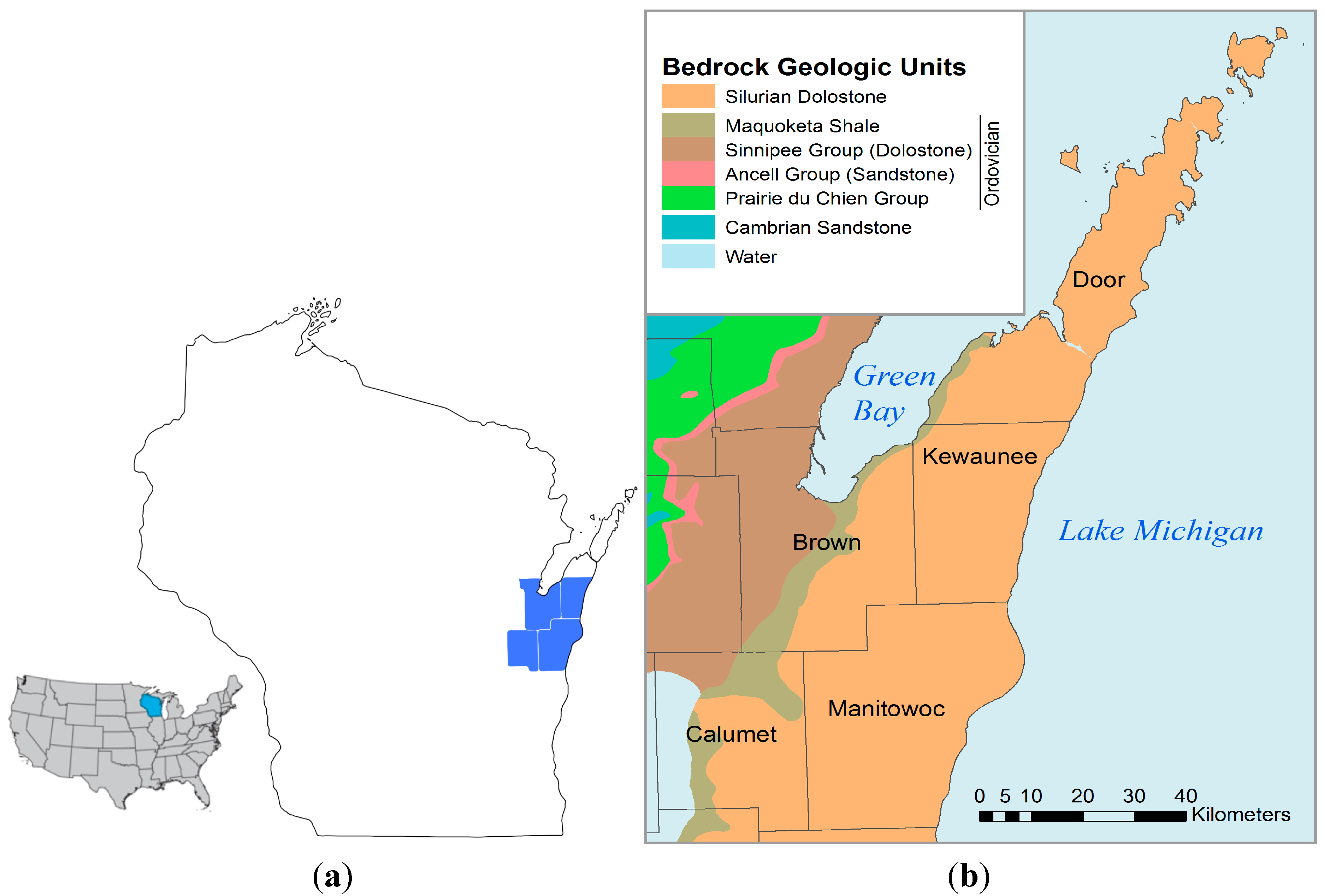
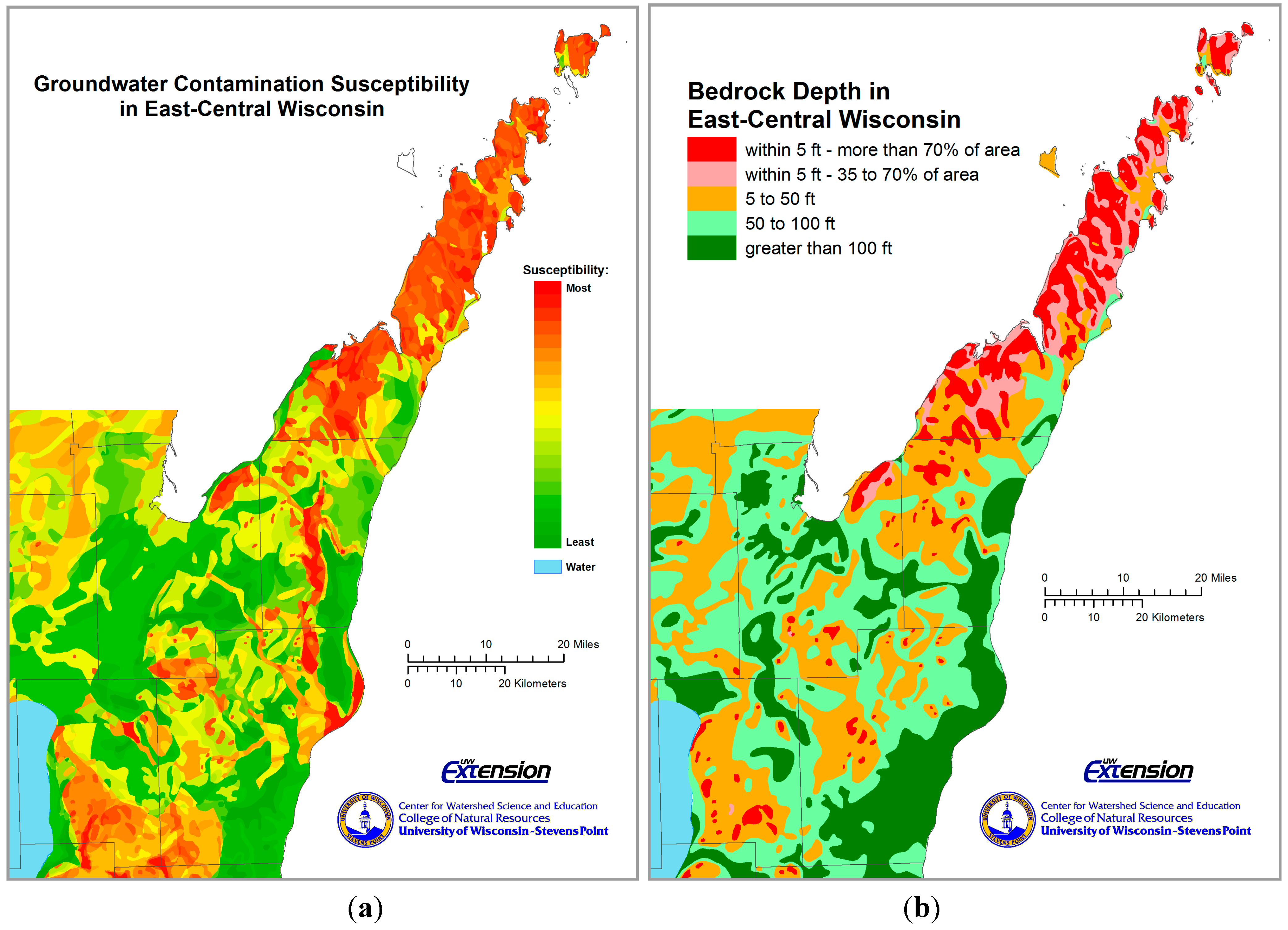
:1. Introduction


| Incident Location | Date | Impact |
|---|---|---|
| Town of Morrison, Brown County | February–March, 2006 | 78 wells tested unsafe for coliform bacteria and/or E. coli |
| Town of Franklin, Manitowoc County | 2005 | 10 wells tested unsafe for coliform bacteria; 6 positive for E. coli |
| Town of Luxemburg, Kewaunee County | March, 2004 | A single well contamination by manure that tested positive for E. coli resulted in severe illnesses and hospitalizations |
2. Results of the 2007 Karst Task Force (KTF)
2.1. Purpose and Justification
2.2. Regulatory and Policy Responses to the 2007 KTF Report
3. Methods
3.1. Data Sources and Statistical Analysis
3.2. Data Limitations
4. Results
4.1. Restrictions on Frozen Ground Spreading
4.2. Presence or Absence of Frozen Soil
5. Discussion
6. Future Trends
7. Conclusions
Acknowledgments
Author Contributions
Conflicts of Interest
References
- Ford, D.; Williams, P. Karst Hydrogeology and Geomorphology, 2nd ed.; John Wiley & Sons Ltd.: West Sussex, UK, 2007; pp. 1–562. [Google Scholar]
- Coxon, C. Chapter 5, Agriculture and Karst. In Karst Management, 1st ed.; van Beynen, P.E., Ed.; Springer: New York, NY, USA, 2011; pp. 103–138. [Google Scholar]
- Guo, F.; Yuan, D.; Qin, Z. Groundwater Contamination in Karst Areas of Southwestern China and Recommended Countermeasures. Acta Carsologica 2015, 32, 389–399. [Google Scholar]
- Worthington, S.R.H.; Smart, C.C.; Ruland, W.W. Assessment of Groundwater Velocities to the Municipal Wells at Walkerton. In Ground and Water: Theory to Practice; Proceedings of the 55th Canadian Geotechnical and 3rd Joint IAH-CNC and CGS Groundwater Specialty Conferences, Niagara Falls, ON, USA, 20–23 October 2002; Stolle, D., Piggott, A.R., Crowder, J.J., Eds.; pp. 1081–1086.
- Celico, F.; Musilli, I.; Naclerio, G. The impacts of pasture- and manure-spreading on microbial groundwater quality in carbonate aquifers. Environ. Geol. 2004, 46, 233–236. [Google Scholar] [CrossRef]
- Hrudey, S.E.; Payment, P.; Huck, P.M.; Gillham, R.W.; Hruday, E.J. A fatal waterborne disease epidemic in Walkerton, Ontario: Comparison with other waterborne outbreaks in the developed world. Water Sci. Technol. 2003, 47, 7–14. [Google Scholar] [PubMed]
- Luczaj, J.A.; Masarik, K. Groundwater Quantity and Quality Issues in a Water-Rich Region: Examples from Wisconsin, USA. Resources 2015, 4, 323–357. [Google Scholar] [CrossRef]
- Center for Watershed Science and Education (CWSE) WI Well Water Viewer. University of Wisconsin-Stevens Point. Available online: http://www.uwsp.edu/cnr-ap/watershed/Pages/WellWaterViewer.aspx (accessed on 29 June 2015).
- Bonness, D.; Masarik, K. Investigating Intra-annual Variability of Well Water Quality in Lincoln Township; Final Report; June 2014; pp. 1–42. Available online: http://www.uwsp.edu/cnr-ap/watershed/Documents/Lincoln_FinalReport.pdf (accessed on 2 July 2015).
- Bauer, A.C.; Wingert, S.; Fermanich, K.J.; Zorn, M.E. Well water in karst regions of northeastern Wisconsin contains estrogenic factors, nitrate, and bacteria. Water Environ. Res. 2013, 85, 318–326. [Google Scholar] [CrossRef] [PubMed]
- Borchardt, M.A.; Bradbury, K.R.; Alexander, E.C., Jr.; Kolberg, R.J.; Alexander, S.C.; Archer, J.R.; Braatz, L.A.; Forest, B.M.; Green, J.A.; Spencer, S.K. Norovirus outbreak caused by a new septic system in a dolomite aquifer. Ground Water 2011, 49, 85–97. [Google Scholar] [CrossRef] [PubMed]
- Borchardt, M.A.; Bertz, P.D.; Spencer, S.K.; Battigelli, D.A. Incidence of enteric viruses in groundwater from household wells in Wisconsin. Appl. Environ. Microbiol. 2003, 69, 1172–1180. [Google Scholar] [CrossRef] [PubMed]
- Erb, K.R.; Stieglitz, R. Final Report of the Northeast Wisconsin Karst Task Force; University of Wisconsin—Extension: Madison, WI, USA, 2007; pp. 1–46. [Google Scholar]
- Czymmek, K.; Geohring, L.; Lendrum, J.; Wright, P.; Albrecht, G.; Brower, B.; Ketterings, Q. Manure Management Guidelines for Limestone Bedrock/Karst Areas of Genesee County, New York: Practices for Risk Reduction; Animal Science Publication Series No. 240; Cornell University: Ithaca, NY, USA, 2011; pp. 1–9. Available online: http://nmsp.cals.cornell.edu/publications/files/Karst_2_15_2011.pdf (accessed on 8 August 2015).
- Ronk, E.; Erb, K. A Preliminary Analysis of 300 Manure Incidents in Wisconsin. In Proceedings of the 2010 Wisconsin Crop Management Conference, Madison, WI, USA, 12–14 January 2010.
- Gupta, S.; Munyankusi, E.; Moncrief, J.; Zvomuya, F.; Hanewall, M. Tillage and Manure Application Effects on Mineral Nitrogen Leaching from Seasonally Frozen Soils. J. Environ. Qual. 2004, 33, 1238–1246. [Google Scholar] [CrossRef] [PubMed]
- Luczaj, J.A. Geology of the Niagara escarpment in Wisconsin. Geosci. Wis. 2013, 22, 1–34. Available online: http://wgnhs.uwex.edu/pubs/gs22a01/ (accessed on 2 July 2015). [Google Scholar]
- Mudrey, M.G., Jr.; Brown, B.A.; Greenberg, J.K. Bedrock Geologic Map of Wisconsin; University of Wisconsin-Extension, Geological and Natural History Survey: Madison, WI, USA, 1982; scale= 1:1,000,000. [Google Scholar]
- NOAA—National Weather Service, Index of Climate Images for Wisconsin. Available online: http://www.crh.noaa.gov/images/mkx/climate/ (accessed on 2 July 2015).
- Wisconsin State Climatology Office (WSCO). Statewide Wisconsin Climate Data. Available online: http://www.aos.wisc.edu/~sco/clim-history/state/ (accessed on 2 July 2015).
- University of Wisconsin-Extension, Wisconsin Cooperative Observer Database, Wisconsin State Climatology Office (WSCO). Available online: http://agwx.soils.wisc.edu/uwex_agwx/weather/hyd (accessed on 7 July 2015).
- Wisconsin State Climatology Office (WSCO). Wisconsin Winter Climate. Available online: http://www.aos.wisc.edu/~sco/seasons/winter.html#Snow (accessed on 2 July 2015).
- Department of Agriculture, Trade and Consumer Protection (DATCP). Agricultural Chemicals in Wisconsin Groundwater (April 2008). Available online: http://datcp.wi.gov/uploads/Environment/pdf/ARMPub180.pdf (accessed on 20 August 2015).
- Krohelski, J.T. Hydrogeology and Ground-Water Use and Quality, Brown County, Wisconsin; Wisconsin Geological and Natural History Survey: Madison, WI, USA, 1986; Volume 57, pp. 1–42. [Google Scholar]
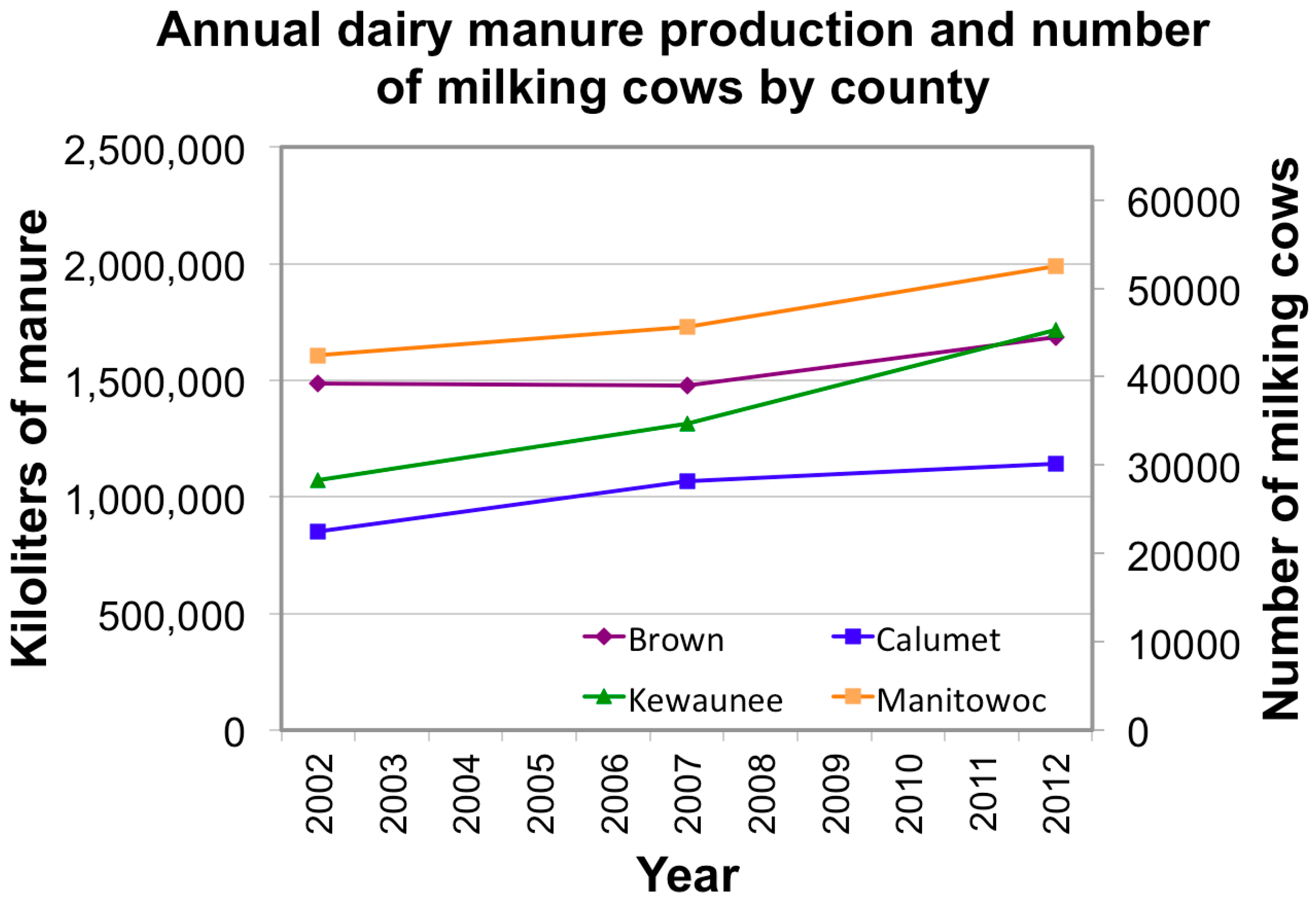
- United States Department of Agriculture, National Ag Statistics Service (UDSA, NASS). 2002 Census of Agriculture. Available online: http://www.agcensus.usda.gov/Publications/2002/ (accessed on 8 July 2015).
- USDA, NASS. 2007 Census of Agriculture. Available online: http://www.agcensus.usda.gov/Publications/2007/ (accessed on 8 July 2015).
- USDA, NASS. 2012 Census of Agriculture. Available online: http://www.agcensus.usda.gov/Publications/2012/ (accessed on 8 July 2015).
- United States Department of Agriculture, Natural Resources Conservation Service. March 2005 Wisconsin NRCS 590 Standard. 4 July 2015. Available online: http://efotg.sc.egov.usda.gov/references/public/WI/590.pdf (accessed on 8 July 2015). [Google Scholar]
- Warzecha, C.; Gerhardt, R.; Kluender, S. Wisconsin Private Well Water Quality Survey; NGWIC Call Number GB1025.W6.W45; Wisconsin Department of Natural Resources: Madison, WI, USA, 2015.
- Heinen, L.; Drinking Water and Ground Water Specialist, Wisconsin Department of Natural Resources. Personal Communication, 7 April 2015.
- Smith, T.; Resource Conservationist, Manitowoc Soil and Water Conservation Department, Manitowoc, WI, USA. Personal Communication, 7 April 2015.
- Riesterer, B.; Resource Conservationist, Manitowoc Soil and Water Conservation Department, Manitowoc, WI, USA. Personal Communication, 7 April 2015.
- Manitowoc County, Wisconsin. Ordinances, Chapter 19, Animal Waste Management. Available online: http://www.manitowoccounty.com/Upload/8/Chapter%2019%20-%202011-0118H.pdf (accessed on 5 May 2015).
- Brown County, Wisconsin. Ordinances, Chapter 26, Animal Waste Management. Available online: http://www.co.brown.wi.us/i_brown/d/county_clerk/2013_web/chap026-updated_6-24-13.pdf?t=1373902597 (accessed on 5 May 2015).
- Kleiber, A.; Land Resource Specialist, Calumet County Land and Water Conservation Department, Chilton, WI, USA. Well water incidents. Personal Communication, 4 April 2015. [Google Scholar]
- Reali, A.; County Conservationist, Calumet County Land and Water Conservation Department, Chilton, WI, USA. Well water incidents. Personal Communication, 8 April 2015. [Google Scholar]
- Santry, D.; Water Resource Specialist, Calumet County Land and Water Conservation Department, Chilton, WI, USA. Well water incidents. Personal Communication, 8 April 2015. [Google Scholar]
- Schuster, W.; County Conservationist, Door County Soil and Water Conservation Department, Sturgeon Bay, WI, USA. Well water incidents. Personal Communication, 7 April 2015. [Google Scholar]
- Schuster, W.; County Conservationist, Door County Soil and Water Conservation Department, Sturgeon Bay, WI, USA. Brown water incidents. Personal Communication, 27 June 2015. [Google Scholar]
- Bonness, D.; County Conservationist, Kewaunee County, Wisconsin Land and Water Conservation Department, Luxemburg, WI, USA. Personal Communication, 7 April 2015.
- Layton, A.; McKay, L.; Williams, D.; Garrett, V.; Gentry, R.; Sayler, G. Development of Bacteroides 16S rRNA Gene TaqMan-Based Real-Time PCR Assays for Estimation of Total, Human, and Bovine Fecal Pollution in Water. Appl. Environ. Microbiol. 2006, 72, 4214–4224. [Google Scholar] [CrossRef] [PubMed]
- Wergin, A.; RN BSN, Health Officer, Manitowoc County Health Department, Manitowoc, WI, USA. Karst Data. Personal Communication, 17 June 2015. [Google Scholar]
- Kinnard, C.; Registered Nurse, Public Health Director, Kewaunee County Health Department, Kewaunee, WI, USA. Karst Paper. Personal Communication, 18 May 2015. [Google Scholar]
- Halverson, J.; County Conservationist, Manitowoc County, Wisconsin Soil and Water Conservation Department, Manitowoc, WI, USA. Research Paper. Personal Communication, 5 May 2015. [Google Scholar]
- Bonness, D.; County Conservationist, Kewaunee County, Wisconsin Land and Water Conservation Department, Luxemburg, WI, USA. Personal Communication, 4 April 2015.
- Jolly, J.; County Conservationist, Brown County Land and Water Conservation Department, Green Bay, WI, USA. Personal Communication, 3 April 2015.
- Santry, D.; Water Resource Specialist, Calumet County Land and Water Conservation Department, Chilton, WI, USA. Karst Data Request. Personal Communication, 14 April 2015. [Google Scholar]
- Gollman, R.; Environmental Lab Manager, Brown County (WI) Health Department, Green Bay, WI, USA. Personal Communication, 13 May 2015.
- Komiskey, M.J.; Stuntebeck, T.D.; Frame, D.R.; Madison, F.W. Nutrients and sediment in frozen-ground runoff from no-till fields receiving liquid-dairy and solid-beef manures. J. Soil Water Conserv. 2011, 66, 303–312. [Google Scholar] [CrossRef]
- State of Wisconsin. Final Report of the Manure Management Task Force; Wisconsin Department of Ag, Trade and Consumer Protection: Madison, WI, USA, 10 March 2006.
- Wergin, A.; RN BSN, Health Officer, Manitowoc County Health Department, Manitowoc, WI, USA. Karst Data. Personal Communication, 17 June 2015. [Google Scholar]
- Jolly, J.; County Conservationist, Brown County Land and Water Conservation Department, Green Bay, WI, USA. Personal Communication, 3 April 2015.
- Kinnard, C.; Registered Nurse, Public Health Director, Kewaunee County Health Department, Kewaunee, WI, USA. Maps for paper. Personal Communication, 18 May 2015. [Google Scholar]
- Merry, J.; Water Supply Specialist, Hydrogeologist, WDNR, Green Bay, WI, USA. Karst Paper. Personal Communication, 8 June 2015. [Google Scholar]
- Wisconsin State Climatology Office (WSCO). Green Bay Climate—Number of Days of 1 Inch or More Now Cover Per Snow Season: Green Bay Airport (1949/1950–2013/2014 season). Available online: http://www.aos.wisc.edu/~sco/clim-history/stations/grb/GRB-AP-D-snwcv.gif (accessed on 2 July 2015).
- USDA, NRCS. Draft March 2015 Wisconsin NRCS 590 Standard. Available online: http://socwisconsin.org/wp-content/uploads/2015/03/Draft590Standard_BroadReview.pdf (accessed on 15 April 2015).
- USDA, NRCS. Draft March 2015 Wisconsin NRCS 590 Tech Note 1. Available online: http://socwisconsin.org/wp-content/uploads/2015/03/590TechNote_BroadReview1.pdf (accessed on 15 April 2015).
- Murphy, P.; State Resource Conservationist, United States Department of Agriculture Natural Resources Conservation Service, Madison, WI, USA. Personal Communication, 13 April 2015.
© 2015 by the authors; licensee MDPI, Basel, Switzerland. This article is an open access article distributed under the terms and conditions of the Creative Commons Attribution license (http://creativecommons.org/licenses/by/4.0/).
Share and Cite
Erb, K.; Ronk, E.; Koundinya, V.; Luczaj, J. Groundwater Quality Changes in a Karst Aquifer of Northeastern Wisconsin, USA: Reduction of Brown Water Incidence and Bacterial Contamination Resulting from Implementation of Regional Task Force Recommendations. Resources 2015, 4, 655-672. https://doi.org/10.3390/resources4030655
Erb K, Ronk E, Koundinya V, Luczaj J. Groundwater Quality Changes in a Karst Aquifer of Northeastern Wisconsin, USA: Reduction of Brown Water Incidence and Bacterial Contamination Resulting from Implementation of Regional Task Force Recommendations. Resources. 2015; 4(3):655-672. https://doi.org/10.3390/resources4030655
Chicago/Turabian StyleErb, Kevin, Eric Ronk, Vikram Koundinya, and John Luczaj. 2015. "Groundwater Quality Changes in a Karst Aquifer of Northeastern Wisconsin, USA: Reduction of Brown Water Incidence and Bacterial Contamination Resulting from Implementation of Regional Task Force Recommendations" Resources 4, no. 3: 655-672. https://doi.org/10.3390/resources4030655