Lake Area Changes and Their Influence on Factors in Arid and Semi-Arid Regions along the Silk Road


1
Chongqing Engineering Research Center for Remote Sensing Big Data Application, School of Geographical Sciences, Southwest University, Chongqing 400715, China
2
Chongqing Key Laboratory of Karst Environment, School of Geographical Sciences, Southwest University, Chongqing 400715, China
3
Department of Geography and Environmental Science, University of Reading, Reading RG6 6AB, UK
*
Authors to whom correspondence should be addressed.
Remote Sens. 2018, 10(4), 595; https://doi.org/10.3390/rs10040595
Submission received: 9 March 2018
/
Revised: 7 April 2018
/
Accepted: 9 April 2018
/
Published: 12 April 2018
(This article belongs to the Special Issue Remote Sensing of Inland Waters and Their Catchments)
Abstract
:In the context of global warming, the changes in major lakes and their responses to the influence factors in arid and semi-arid regions along the Silk Road are especially important for the sustainable development of local water resources. In this study, the areas of 24 lakes were extracted using MODIS NDVI data, and their spatial-temporal characteristics were analyzed. In addition, the relationship between lake areas and the influence factors, including air temperature, precipitation, evapotranspiration, land use and land cover change (LULCC) and population density in the watersheds, were investigated. The results indicated that the areas of most lakes shrank, and the total area decreased by 22,189.7 km2 from 2001 to 2016, except for those of the lakes located on the Qinghai-Tibetan Plateau. The air temperature was the most important factor for all the lakes and increased at a rate of 0.113 °C/a during the past 16 years. LULCC and the increasing population density markedly influenced the lakes located in the middle to western parts of this study area. Therefore, our results connecting lake area changes in the study region highlight the great challenge of water resources and the urgency of implementation of the green policy in the One Belt and One Road Initiative through international collaboration.
1. Introduction
Lakes, as geographical units, are markedly affected by environmental changes and human activities. Great changes have occurred in many lakes across the world in the past few decades, including changes in size, shape and ecology [1,2,3]. For example, in the past decades, the increase of air temperature has resulted in the melting of glaciers and snow, and the expansion of lake areas in many areas of the Qinghai-Tibet Plateau [4,5,6]. However, in arid and semi-arid areas, many lake areas have decreased sharply because of drought, global warming, strong evaporation, and increasing population, with a great increase in water consumption for life and production [1]. Playing a key role in hydrological cycles, lakes affect many aspects of society and ecosystems, such as water storage, moderation of climate, and energy production and irrigation, especially in arid and semi-arid regions [7,8,9,10,11]. Meanwhile, fluctuations in lake areas may result in disasters such as floods in humid regions and water shortages in arid and semi-arid regions [12,13]. Therefore, timely monitoring of the areas, located in especially vulnerable arid and semi-arid regions, for example, along the Silk Road, is necessary and important for policy makers.
The Silk Road is an ancient network of trade routes stretching from China to the Mediterranean Sea. In 2013, the strategy of the One Belt and One Road Initiative including the Silk Road Economic Belt and the 21st Century Maritime Silk Road was proposed by the Chinese government, and has received increasing attention from the international community. Meanwhile, Chinese governments are paying increasingly attention to global environmental change, especially climate change [14]. Global environmental change creates regional differences and ecosystem responses. The study of a regional response is an indispensable basis for the overall estimate of the impact of global change on the local environment and society. Therefore, the regional response to global environmental change has constituted the theme of the current research about sustainable development [15,16]. For the regional study, Cheng et al. extracted the area of seven lakes in Central Asia using Landsat data in the years of 1978, 1989, 1998, and 2010, and the results indicated that the area of lakes had decreased from 1978 to 2010 except for the Sarykamish Lake [17]. Bai et al. used Normalized Difference Water Index (NDWI) to extract the area of nine lakes in Central Asia based on Landsat data from 1975 to 2007, and the result showed that total surface area of the nine lakes had decreased continuously from 91,402.06 km2 to 46,049.23 km2 during the period [18]. Meanwhile, many scholars researched the area change of single lake in this area, such as Lake Urmia, Aral Sea, Bosten Lake, Lake Issykkul and Caspian Sea, and most of them had a decrease in area [19,20,21].
With regards to the extracting of lake areas for large-scale studies, high-resolution Landsat Thematic Mapper (TM)/Enhanced Thematic Mapper (ETM+) remote sensing images have frequently been used to obtain lake areas at a given moment [18,22,23]. In addition, the lake area at a given moment indicates the area of the lake in a particular period [24]. The lake area captured at a given point in time is insufficient to reflect inter-annual and annual variations because of the possible fluctuations of the lake area in the short term. The time-series of the normalized difference vegetation index (NDVI), an important vegetation index remote sensing product, has been used in many studies on global or regional climate change, land use and land cover change (LULCC), vegetation phenology, and lake area [16,25,26,27,28]. Lakes in Ruoqiang County, Xinjiang, West China, have been analyzed using Terra/Moderate-resolution Imaging Spectroradiometer (MODIS) Normalized Difference Vegetation Index (NDVI) data. Based on high resolution spatial data, the time series of retrieval results based on 250 m MODIS data has been shown to be highly accurate [29]. Poyang Lake, one of the five largest freshwater lakes in China, was also studied by using MODIS NDVI data. Compared with using the lake area derived from Landsat ETM+, using MODIS NDVI data to extract lake area performs well, with a correlation coefficient of 0.95 [30].
As the important node of the atmosphere, hydrosphere, lithosphere, and biosphere, lake shape and size have undergone marked changes due to the collective effects of the natural environment and human activities. The changes of lake area and the analysis of its influencing factors are the hot issues in today’s research. Qin et al. conducted the analysis of evolution and the causes of inland lakes in Central Asia, and the results indicated that the lake area decreased with the air temperature increase, precipitation reduction, and water extraction increase caused by human activities [31]. Yan et al. analyzed the changes of lakes in the Qinghai Tibetan Plateau and their responses to climate change in the past 40 years. The results showed that geological structure controls the general pattern of lake change, and climate factors mainly affected lake changes over a short time. In addition, factors such as glacier, human activity, shape of lake basin, and recharge and discharge area also affect the dynamic changes of the lake [32]. Generally, climate factors (air temperature, precipitation, evapotranspiration, wind speed, air humidity and glaciers), geological factors (lake basin shape, recharge and discharge area), and human activities (irrigation and building reservoir) all influence the change of lake area [19,20,21,32,33]. However, most scholars just focused on the impact of air temperature and precipitation on the change in lake area, and papers that analyze the effects of human activities on the changes in lake area are relatively rare.
At present, for research on lake areas, most scholars focus on the study of an individual lake by using long time series products with higher time resolution or Landsat data with a high spatial resolution [3,18,34,35]. However, to best of our knowledge, many scientists who are pursuing research on lakes in regions of high interest, such as the Qinghai-Tibetan Plateau, use mainly higher spatial resolution images in different periods [3,36,37,38]. In addition, they may ignore the seasonal information for these lakes. Unlike many previous studies, we studied the changes in lake areas in arid and semi-arid regions by using the product of long time series and higher time resolution MODIS NDVI, and we took the lakes along the Silk Road as an example. The objectives of this study are (1) to analyze the continuous long-time changes in lake area; (2) to estimate the change trends of the factors that influence lake area, including air temperature, precipitation, evapotranspiration, LULCC, and population density; and (3) to identify the key reasons for the lake area changes.
2. Materials and Methods
2.1. Study Area
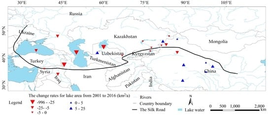
The main research area of this paper is the arid and semi-arid area along the Silk Road, (26°–110°E, 36°–50°N) (Figure 1). The region includes part of northwest China, central Asia, part of western Asia and south-east Europe, including Afghanistan, Iran, Iraq, Turkey, Syria, Ukraine, and 25 other countries within Eurasian continent. The topography of the area is especially complicated as it includes mountains, hills, plateaus, basins, plains, and deserts. The study area is located in the hinterland of the Eurasian continent and is far away from the Atlantic, Indian and Pacific Oceans. In addition, the barrier of high mountains and a high plateau block the southeast monsoon, the prevailing westerly wind, and the southwest monsoon from reaching this area. As a result, the region has a typical temperate continental climate. The annual precipitation in the area is low and concentrated in the summer, the regional distribution is uneven, and the evaporation is high. Therefore, most of the study area is arid (annual precipitation of less than 200 mm) and semi-arid area (annual precipitation of 200–400 mm).
Despite the low precipitation, in arid and semi-arid regions, there are abundant heat and energy resources. Along the rivers and lakes with abundant water resources, there are many cities and industries, and much irrigated agriculture. In addition to the cities’ domestic consumption, water is also extracted from rivers and lakes for agricultural irrigation and industrial activities.
In this research, 24 lakes with large areas (>400 km2) lying to the Silk Road in arid and semi-arid regions were selected for analyzing the area changes from 2001 to 2016.
2.2. Data and Preprocessing
2.2.1. MODIS NDVI Data
This paper used the 250 m vegetation index product MOD13 Q1 provided by the United States Geological Survey [39], which was synthetized by selecting the pixels that were at the subastral point and cloudless on 16 days, and the effects of clouds, shadows, and aerosols in the atmosphere and other possible effects were minimized [40]. In total, 3312 MOD13 Q1 images of the study area from 2001 to 2016 were downloaded. MODIS Re-projection Tools were used to extract the NDVI band from the MODIS Q1 data, transform the projection and mosaic the images. The Albers projection was selected with WGS-84 as the geographical coordinate system, 105°E as the central meridian, 25°N as the first standard parallel and 47°N as the second standard parallel. Meanwhile, NDVI data were reconstructed to eliminate abnormal value caused by sensor, clouds and other factors [25].
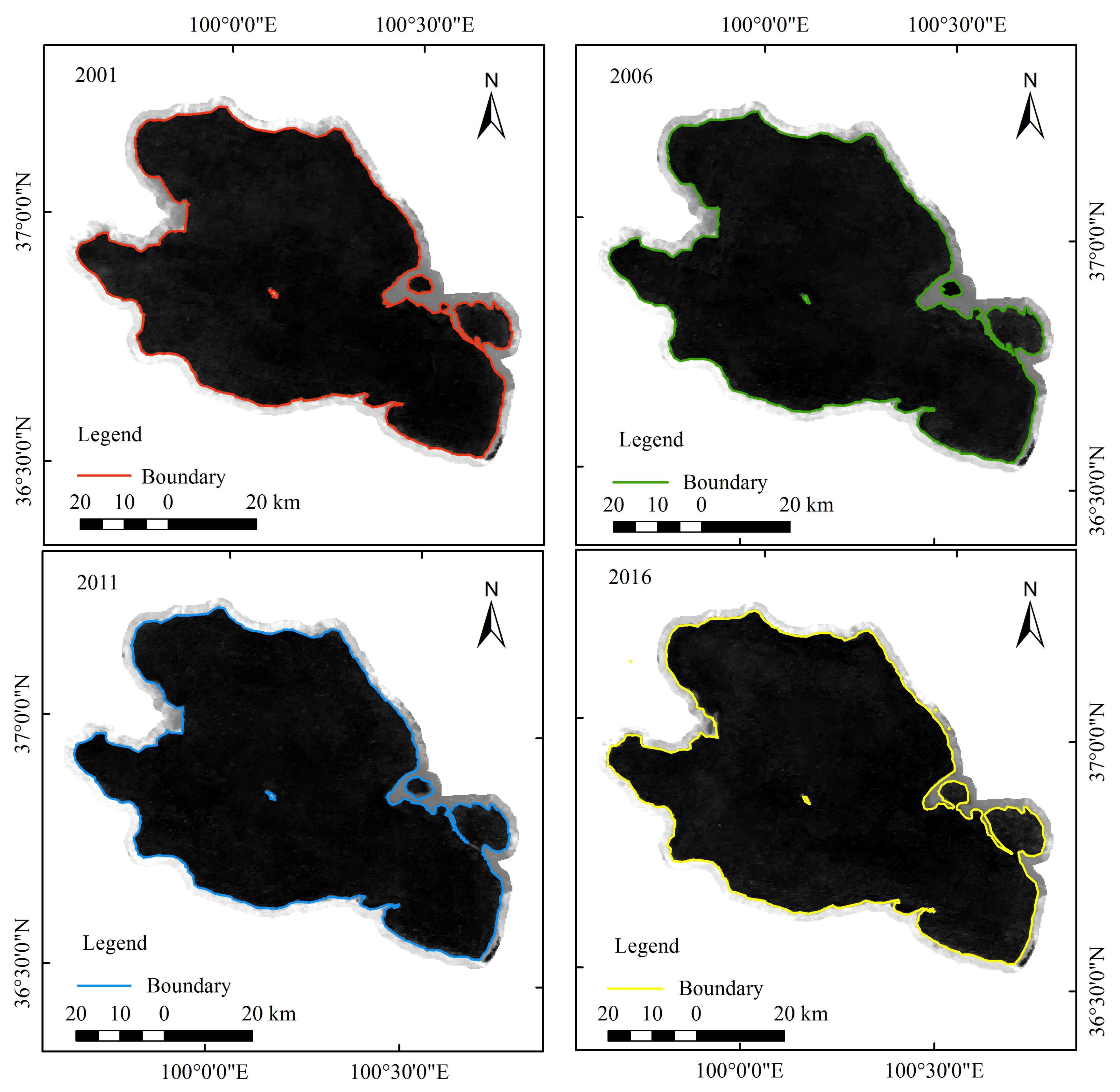
NDVI data were selected to extract water area, which has been used to research the change of lake area [29,41,42]. The first band of MODIS data is 620–670 nm (red). In this wavelength range, the reflectance of water body is higher than vegetation. The second band is 841–876 nm (near infrared), and the reflectance of vegetation is higher than that of water body. Therefore, in the visible and near infrared band range, the spectral reflectance difference among water, vegetation, urban areas and soil is the basic principle of using remote sensing to extract water. The annual average NDVI values were calculated by using program code, which considered 23 images in one year. As a consequence, 16 images presenting 16 years were obtained to compute the lake areas. To avoid the influence of hill shade, the region of interest was used to cut out the regions that exceeded the maximum lake area using the ENVI software (Exelis Visual Information Solutions, Boulder, CO, USA). Like previous studies [7,42,43], this paper also used 0 as the partition value of NDVI. Taking Qinghai Lake as an example to validate the accuracy, the result show that the boundaries extracted using NDVI data were consistent with water boundaries in MODIS images (Figure 2). When the NDVI is negative, the ground is covered with water. When the NDVI equals to 0, the ground is rock or bare soil. When the NDVI is positive, the ground is covered with vegetation. In addition, the NDVI value increases with the increase in vegetation coverage [44]. After extracting the lake area, the change rate of the lake area was calculated by using Equation (1) [45]:
where n represents the number of years (i = 1 for 2001, i = 2 for 2002 and so on). Aveyeari is the mean value of year i in the region (air temperature, precipitation and so on). Change rate is the change rate of a linear regression equation, which indicates that the factor is increasing in the year n if the change rate is greater than 0 and otherwise, it is decreasing. The greater the change rate is, the more obvious the trend becomes.
2.2.2. Meteorological Data
Meteorological data were acquired from the Global Land Assimilation System (GLDAS) [46], a global land surface simulation system with a high resolution of 0.25 degrees [47]. In addition, GLDAS supplies 28 surface process parameters, including mainly air temperature, precipitation, radiation, soil moisture, soil air temperature and wind speed. In this study, the data for air temperature, precipitation, and evapotranspiration were selected from the GLDAS-2.1 Noah model from 2001 to 2016, with a 0.25-degree spatial resolution and one-month temporal resolution. MATLAB (Matrix Laboratory, Math Works) was used to extract the GLDAS meteorological data. The meteorological data were synthesized into a yearly scale, and the change rates for air temperature, precipitation, and evaporation were computed by using program codes.
2.2.3. Watershed Data
The watershed dataset, HydroSHEDS, was obtained from the United States Geological Survey (USGS) based on high-resolution digital elevation model (DEM) data [48]. The data set provides hydrological information from 60°S to 60°N in a uniform format for regional or global applications, including watershed boundaries, river networks, water flow directions, and water flow accumulation. In this study, based on the watershed data with a 450-m spatial resolution, the changes in the factors influencing the watershed, including air temperature, precipitation, evaporation, LULCC, and population density, were studied.
2.2.4. Population Density Data
The population density data were obtained from the NASA Social Data and Application Center (SEDAC) [49]. The Gridded Population of the World, Version 4 (GPWv4) consists of estimates of human population density, based on counts consistent with national censuses and population registers with respect to relative spatial distribution, and it has been adjusted to match the 2015 revision of the United Nations (UN) World Population Prospects country totals for the years 2000, 2005, 2010, and 2015. A proportional allocation gridding algorithm, utilizing approximately 12.5 million national and subnational administrative units, was used to assign population values to 0.0083-degree (1-km) grid cells. The population density grids were created by dividing the population count grids by the land area grids. The pixel values represent persons km-2. The change rates of four images were calculated by using C program codes. The research area was isolated by using ArcGIS 10.2 (ESRI, Redland, CA, USA).
2.2.5. Land Cover Data
Land cover data were derived from the European Space Agency (ESA) climate change initiative (CCI) project [50]. Land cover products with a 300-m spatial resolution are available from 1992 to 2015 and use the coordinate reference system of WGS84. According to the UN Food and Agriculture Organization (FAO) land cover classification system, the global land area is divided into 37 categories [51]. These 37 types of land cover data were merged into seven categories in this study. The land cover transfer matrix was calculated using the ArcGIS software.
Correlations were produced to explore the relationship between lake area and the factors that influence it including air temperature, precipitation, evapotranspiration and LULCC using SPSS 19 (Statistical Product and Service Solutions, IBM, Armonk, NY, USA).
3. Results
3.1. Spatial-Temporal Changes in Lake Area
3.1.1. Temporal Variation in Lake Area
The surface extents of 24 lakes in arid and semi-arid regions along the Silk Road from 2001 to 2016 were extracted. In general, the total areas of 24 lakes decreased from 883,153.3 km2 in 2001 to 860,963.6 km2 in 2016, shrinking by 2.51% during the period (Figure 3). The total area of 24 of the lakes was decreasing at rate of 1619.4 km2/a. A persistent decrease in the total area occurred from 2002 to 2009, and a decrease with slight rebound followed between 2010 and 2014. The total area increased slowly after 2014. In terms of lake numbers, there were 15 lakes with decreasing surface extent, representing more than 60% of the total lakes, whereas there were nine lakes with increasing surface extent, accounting for less than 40% of the total number.
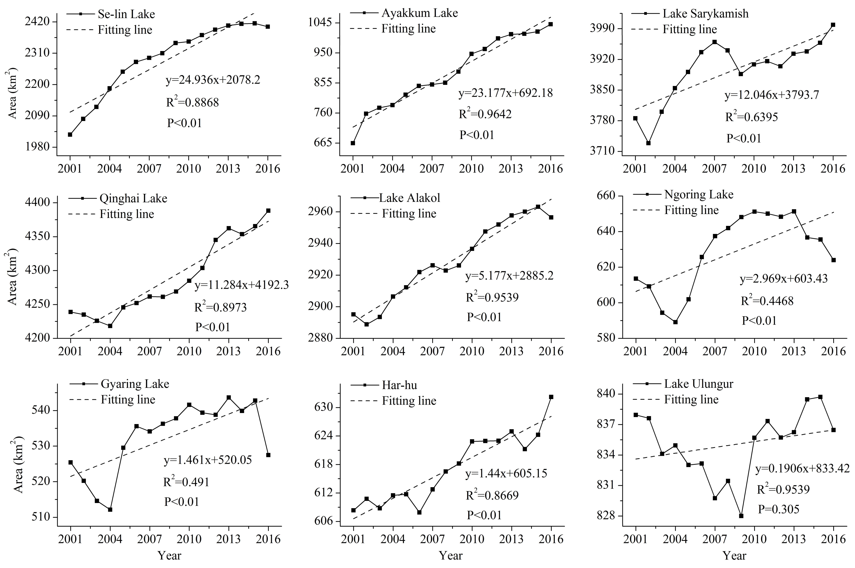
Among the nine lakes with increasing surface areas (Figure 4), only Ayakkum Lake continuously increased in area from 2001 to 2016, and the area of Se-lin Lake had a continuous increase from 2001 to 2015. However, the remaining lakes showed increasing trends but with temporary decreases. In addition, most of them followed the same pattern, namely, a decrease presented in the first several years and an increase followed in the last years. Meanwhile, the turning points were different for each lake. The surface extents of the lakes including Se-lin Lake, Ayakkum Lake, Sarykamish Lake, Qinghai Lake, and Alakol Lake had evident increases, at rates of 5–25 km2/a. The areas of Ngoring Lake, Gyaring Lake, Har-hu, and Ulungur Lake increased at rates of less than 5 km2/a.
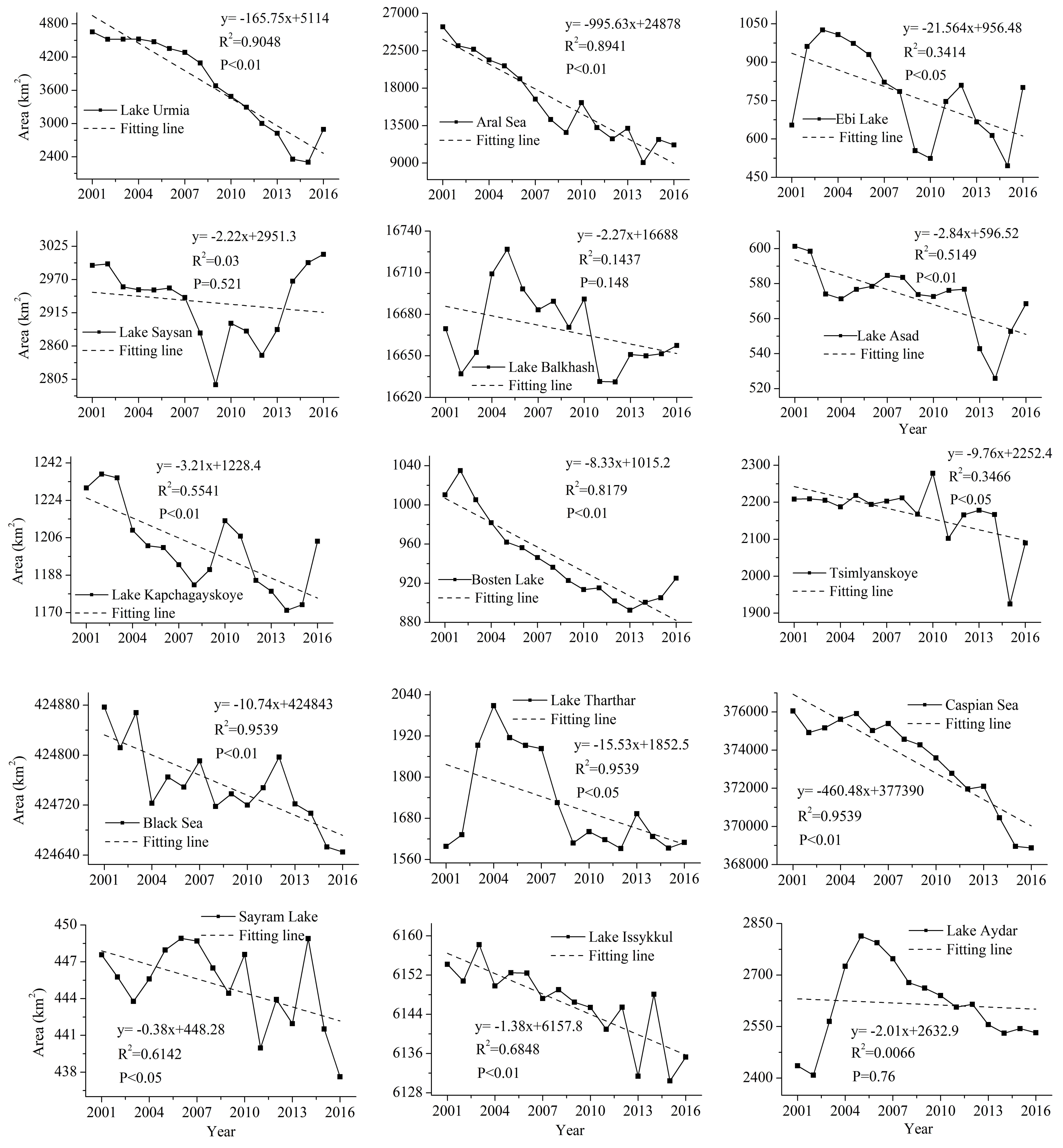
Among the 15 lakes with decreasing surface areas (Figure 5), most presented a decreasing trend in the early stage and an increasing tendency in the later period. Most turning points for lake area changes appeared in 2013, 2014, or 2015, for example, Lake Urmia, the Aral Sea, and Bosten Lake. However, some lakes, including Lake Balkhash, Lake Tharthar, and Lake Aydar, had an increase in area in the early period and a decrease in the later stage. The year of 2004 or 2005 was the turning point. Sharp declines in lake area were found for the Aral Sea, the Caspian Sea, and Lake Urmia, with rates of 995.6 km2/a, 460.5 km2/a, and 165.6 km2/a, respectively. Bosten Lake, Lake Tsimlyanskoye, the Black Sea, Lake Tharthar, and Ebinur Lake had an obvious decrease in lake area, with rates of 8.3 km2/a, 9.8 km2/a, 10.7 km2/a, 15.2 km2/a, and 21.6 km2/a, respectively. Slight decreases were present in the remaining lakes, and the rates of decrease in the lake areas were less than 5 km2/a. Sayan Lake was different from the other lakes, with a decreasing trend from 2001 to 2009 and an increasing tendency after 2009, giving Saysan Lake a minor decrease of 2.22 km2/a during the whole research period.
3.1.2. Spatial Variations in Lake Area Changes
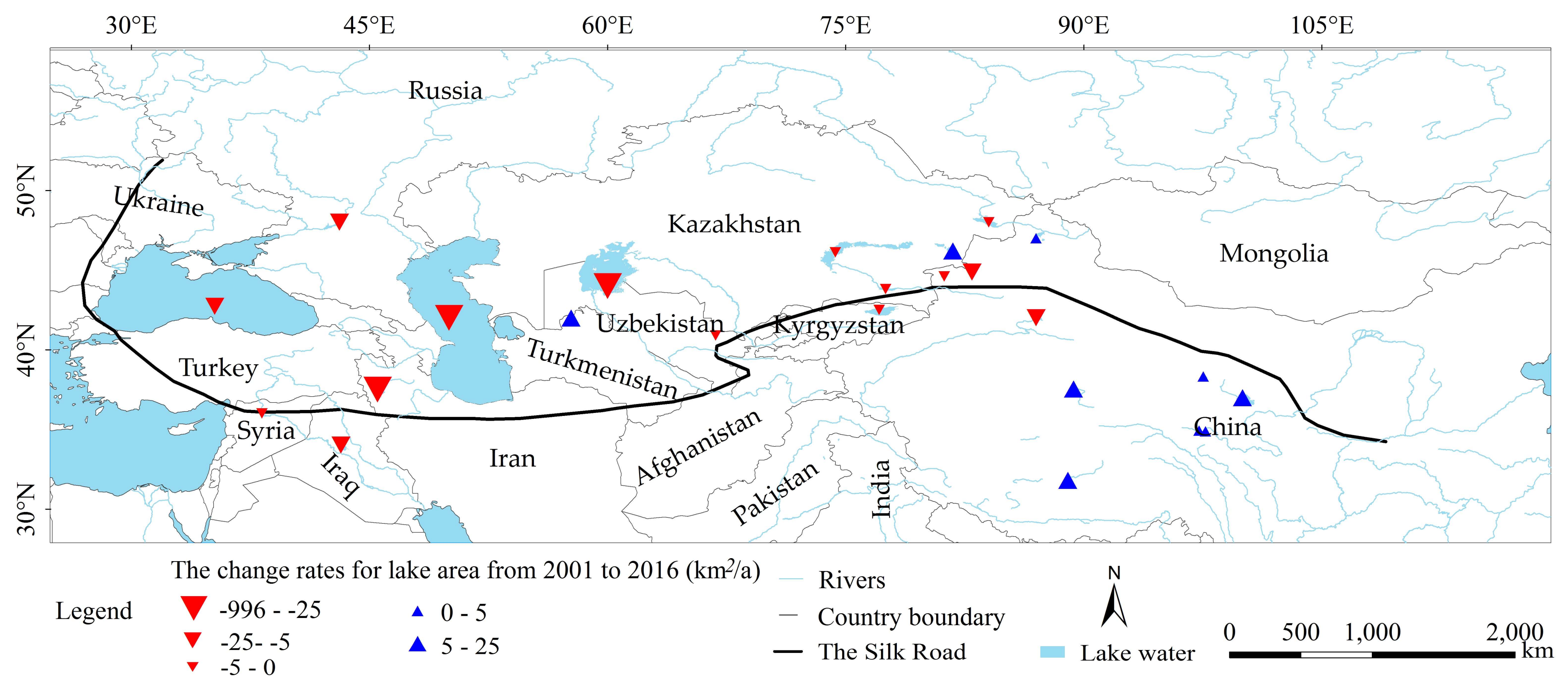
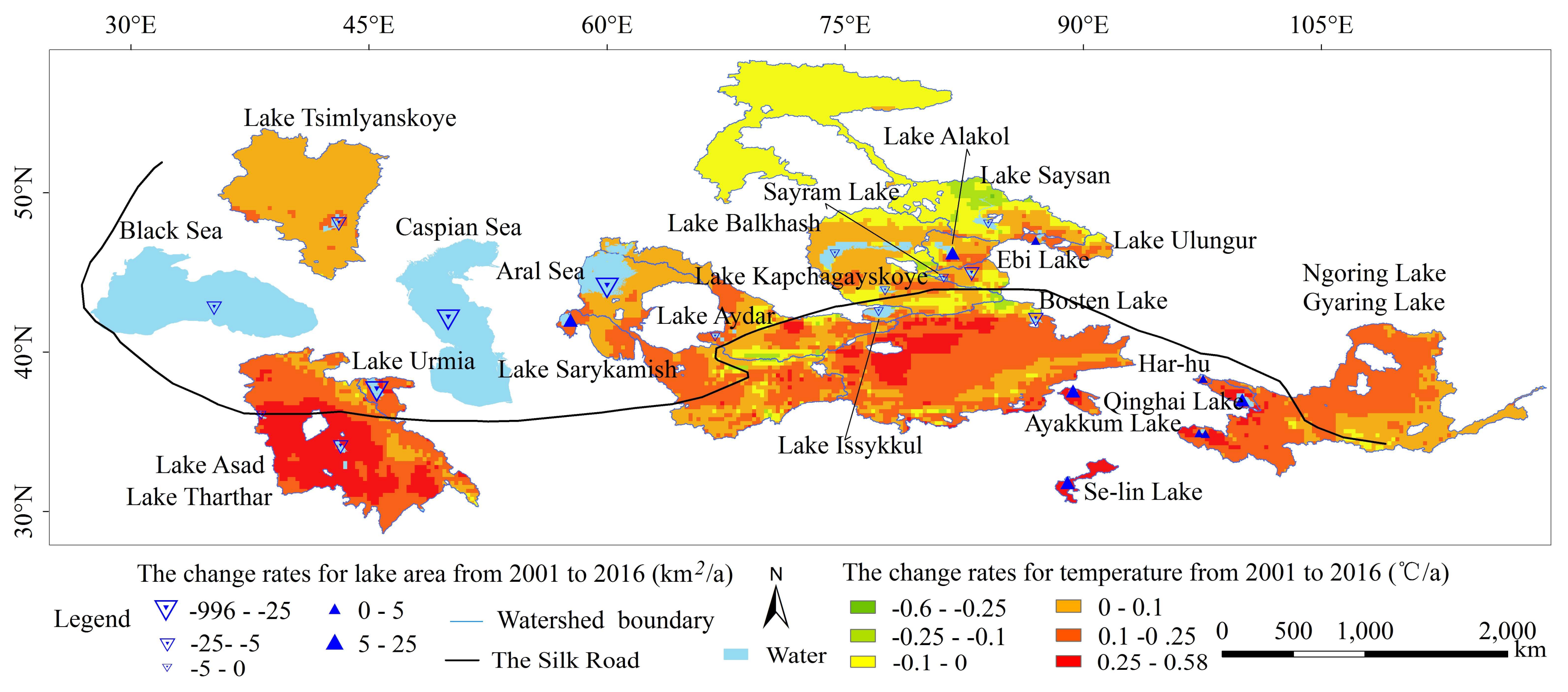
To better analyze the spatial variations of lake areas, the change rates of the 24 lakes were categorized into 5 levels according to the mass distribution map of lake areas change rates in ArcGIS 10.2 (Figure 6). Lakes with increasing surface extent were distributed in the eastern part of the study region, mainly concentrated in the Qinghai-Tibetan Plateau. Meanwhile, lakes located in the middle to western part of this study area had evident decreasing trends, especially the Aral Sea, the Caspian Sea and Lake Urmia with change rates between 25 km2/a and 996 km2/a. In addition, other lakes around the Aral Sea, the Caspian Sea and Lake Urmia had slight declines. However, Lake Sarygamysh located in the between the Aral and Caspian Seas, had an increasing area, which was different from the surrounding lakes.
3.2. Fluctuations in Influencing Factors
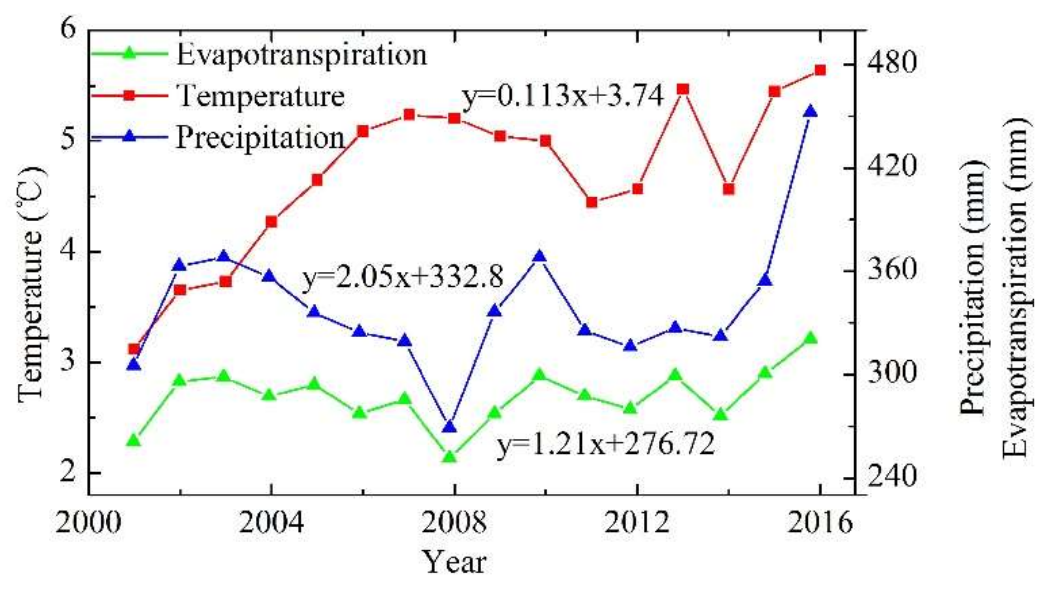
3.2.1. Air Temperature
The air temperature of 22 lakes basins (except for the basins of the Black Sea and the Caspian Sea) distributed in the 19 watersheds increased at an annual rate of 0.113 °C/a in the past 16 years with some fluctuation from 2001 to 2014 (Figure 7). Despite the spatial variations, the air temperatures in most areas increased in the past 16 years, accounting for 81.41% of the area in all watersheds (Figure 8). The air temperatures in some watersheds, including Se-lin Lake, Ayakkum Lake, Lake Asad, and Qinghai Lake had sharp increases at average rates of 0.37 °C/a, 0.225 °C/a, 0.22 °C/a, and 0.201 °C/a, respectively (Table 1). Meanwhile, Bosten Lake, Lake Urmia, Ngoring Lake, and Har-hu had evident increases, with air temperature change rates between 0.1 °C/a and 0.2 °C/a. In addition, the remaining nine lakes only had slight increases. However, only Lake Saysan and Sayram Lake, with change rates of 0.049 °C/a and 0.003 °C/a, experienced decreasing air temperatures in their watersheds, accounting for 18.59% of the area of all basins.
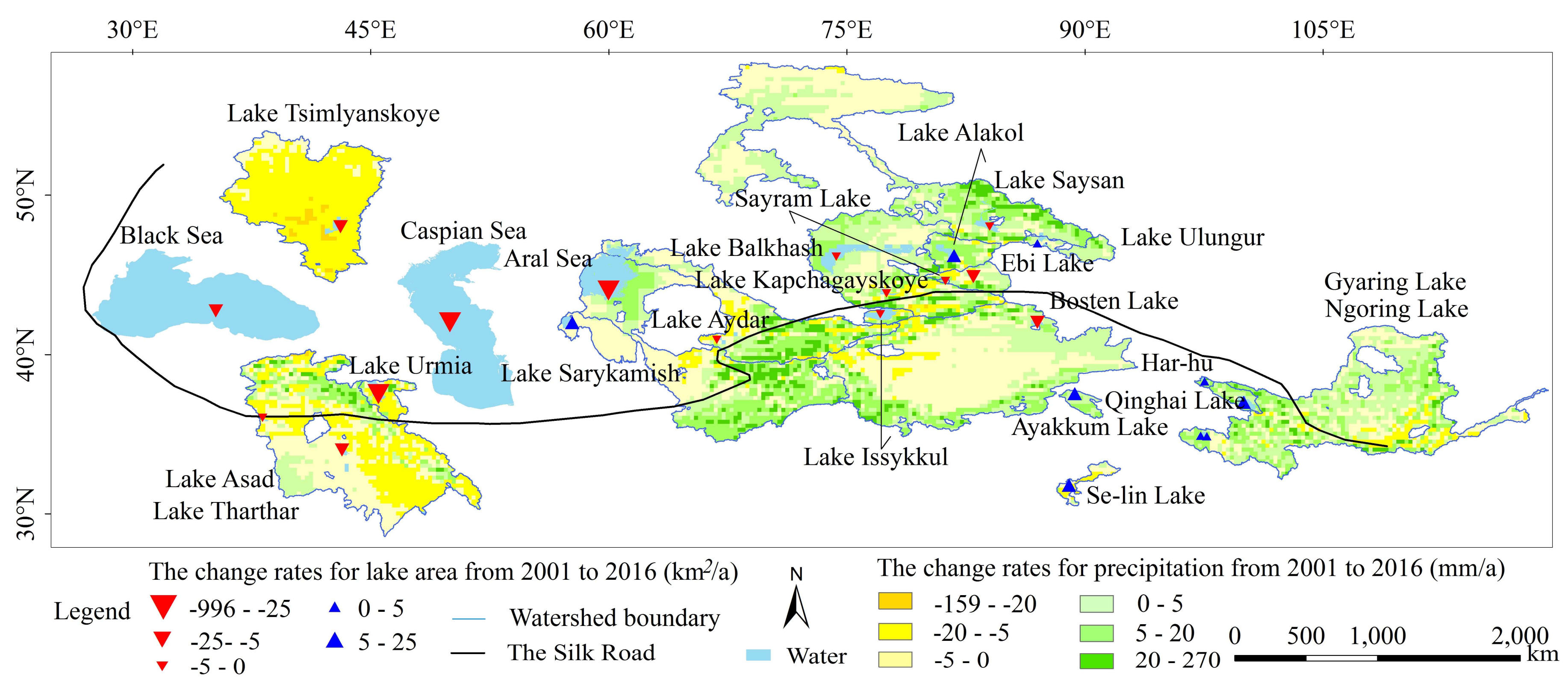
3.2.2. Precipitation
The precipitation in the research area had an increasing trend of 2.05 mm/a, with some fluctuations during the periods 2003–2008 and 2010–2012 (Figure 7). Approximately 47.58% of all basins experienced an increase in precipitation, and they were mainly located in the watersheds of Qinghai Lake, Har-hu, Lake Aydar, and Lake Alakol (Figure 9), with change rates of 6.671 mm/a, 6.527 mm/a, 6.453 mm/a, and 6.398 mm/a, respectively (Table 1). Approximately 52.42% of the basins had decreasing precipitation, mainly in the watersheds of Tsilyanskoye and Se-lin Lake. Meanwhile, Lake Sarykamish, Lake Asad, and Lake Urmia. In particular, the change rate for Tsilyanskoye reached −11.11 mm/a.
3.2.3. Evapotranspiration
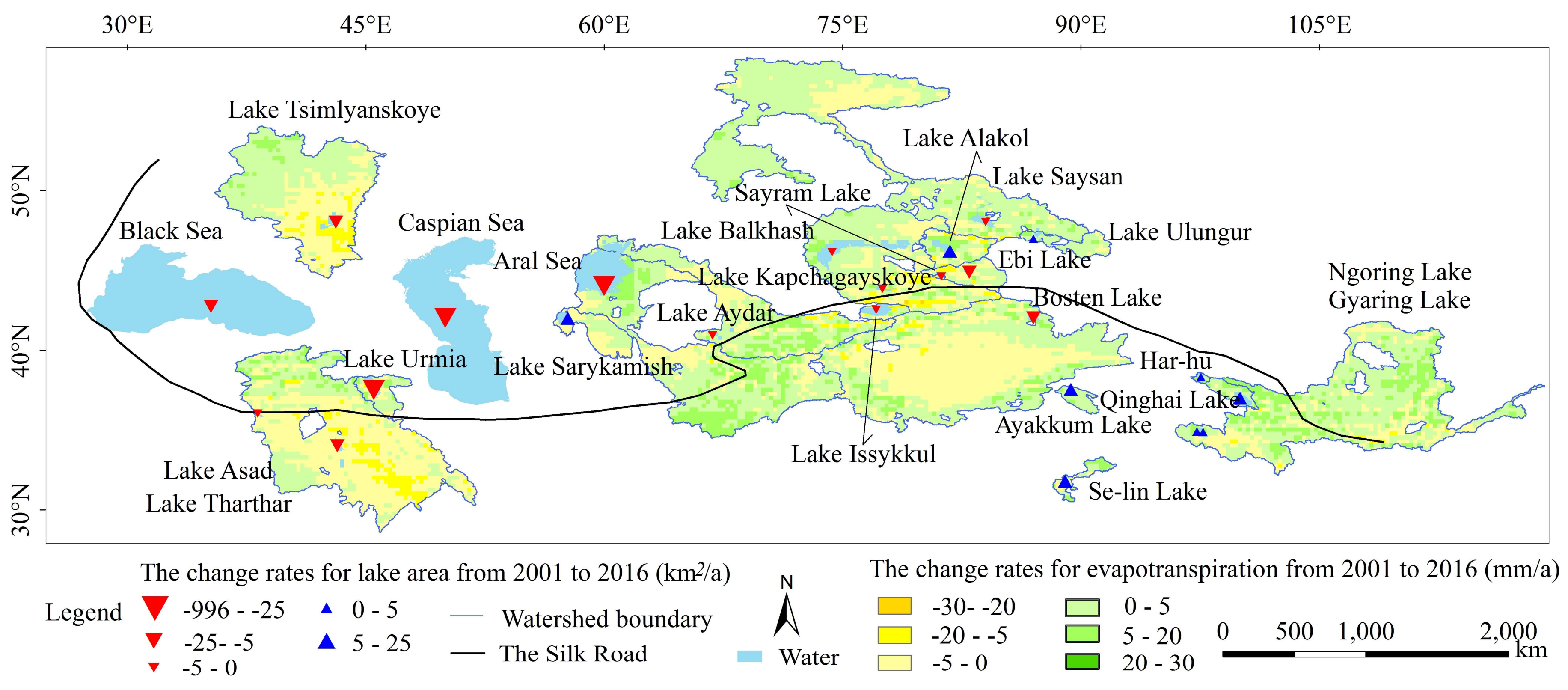
The evapotranspiration in the research area had an increase of 1.21 mm/a, without small fluctuations (Figure 7). The spatial distribution of the change rates for evapotranspiration is similar to that of the change rates for precipitation (Figure 10). In general, 61.71% of all area had an increasing trend for evapotranspiration. The basins of Har-hu, Qinghai Lake, Ayakkum Lake and the Aral Sea had evident increasing trends of more than 3 mm/a. Furthermore, Se-lin Lake, Ngoring Lake and Lake Ulungur also showed obvious increase from 2001 to 2016. On the other hand, approximately 38.28% of the area of all basins decreased in evapotranspiration, and the distribution was relatively dispersed, concentrated mainly in the watersheds of Lake Issykkul, Lake Asad, Sayram Lake, Ebi Lake, and Lake Sarykamish (Table 1).
3.2.4. Land Cover
In total, seven land cover types were analyzed in this study (Table 2). The main land cover types in the watersheds were grassland, followed by bare land, farmland and forest. Wetland and construction land accounted for small proportions. The change rates for five types, including grassland, bare land, farmland, forest, and water body, were positive, indicating an overall increasing trend for these types (Table 2). Among them, the change rate of construction land was the largest, namely, 1.46 × 10³ km2/a. This rate was followed by those for forest, farm land, and grassland, with a change rates of 0.7 × 10³ km2/a, 0.62 × 10³ km2/a, and 0.39 × 10³ km2/a, respectively. The area of construction land increased by 142.98% from 2001 to 2015. However, only bare land and water bodies had decreasing change rates of 1.42 × 10³ km2/a and 1.76 × 10³ km2/a.
A transfer matrix of land cover types was used to reveal the shifts in different land types (Table 3). The area of construction land had an evident increase during the period of 2001–2015, mainly shifting from farmland (11.87 × 10³ km2) and grassland (7.38 × 10³ km2). In addition, the construction land did not change to other land covers, making the construction land an overt increase. The area of farmland exhibited an increasing trend, mainly at the expense of forestland, grassland, and bare land, with the contributions of 10.19 × 10³ km2, 10.71 × 10³ km2, and 10.27 × 10³ km2, respectively. An increase in forestland mainly stemmed from grassland and bare land. Bare land decreased by 17.72 × 10³ km2, shifting mainly to farmland, forest, and grassland. Notably, water bodies decreased by 25.65 × 10³ km2, shifting mostly to bare land.
3.2.5. Population Density
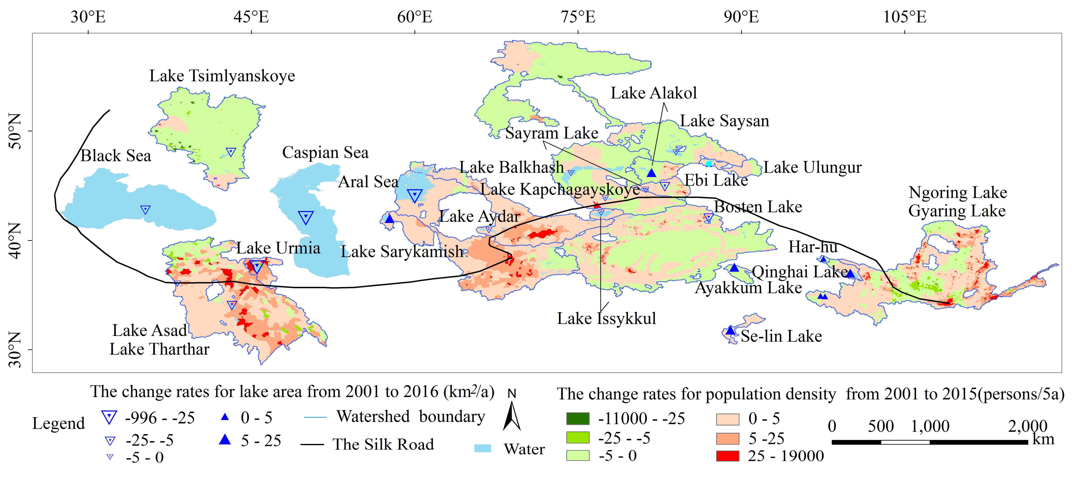
Approximately 57.37% of the basin areas had increases in their population densities (Figure 11), especially for Lake Urmia and Lake Asad, with a change of 11 persons/5a and 7 persons/5a, respectively (Table 1). Meanwhile, Gyaring Lake, the Aral Sea, and Lake Aydar also had the increasing change rates of 4 persons/5a. Approximately 42.63% had a decrease in their population densities. Only the basins of Lake Tsimlyanskoye and Lake Saysan had an evident decreasing trend in population density (Table 1). Other watersheds had small changes in their densities.
3.3. The Correlation of Lake Area and the Factors that Influence It
The correlations of each lake area with its air temperature, precipitation, and evapotranspiration in the watershed were analyzed using SPSS (Table 4). The dotted line in the table is used to divide the lakes into two groups. The upper part includes lakes with increasing lake areas, and the lower part is the opposite. For lakes on the Qinghai-Tibetan Plateau, areas continued increasing, and there was a high correlation with air temperature, indicating that air temperature was especially important for the lakes on the plateau (p < 0.01). However, For Lake Urmai, Lake Asad and the Aral Sea, the lake areas were negatively related to the air temperatures. Lake Sarykamish situated in Turkmenistan had a higher correlation with air temperature (p < 0.01). Unlike other lakes, Bosten Lake and Ebi Lake had decreasing areas. The areas of these two lakes had high correlations with air temperature, precipitation, and evapotranspiration (p < 0.01).
The relationships between lake areas and land covers were different (Table 5). Generally, the change in lake area was closely related to the variation in farmland. Lakes, such as Qinghai Lake and Se-lin Lake had increasing areas with the decreasing farmland in the watershed. On the other hand, some lakes had decreasing their areas with the increasing farmland. However, Lake Sarykamish and Lake Urmia were exceptional.
For other land cover types, although the correlation coefficients between lake area and the land cover types were relatively high, the trend changes in the lake area and the type of land cover were complicated. For example, with increasing construction land, lake areas decreased in some lakes but increased in other lakes.
4. Discussions
Lakes are very sensitive to the regional and global environmental changes and to a series of human activities. Therefore, the change in lake area plays an important role in the investigation of regional water resources and environmental change. In this paper, the changes in 24 lakes were analyzed, and the relationships between the areas of 22 lakes (except for the Black Sea and Caspian Sea) distributed across 19 watersheds that influenced these areas were explored.
In general, the total areas of 24 lakes decreased from 883,153.3 km2 in 2001 to 860,963.6 km2 in 2016, which was consistent with the water bodies extracted from the land cover data with a resolution of 300 m spanning the 19 basins. Cheng et al. (2015) also noted that the areas of major inland lakes in Central Asia shrank to different degrees in the past 30 years [17]. Nevertheless, the lake area of our result was less than that of Cheng’s for the same year because the lake area in this paper was calculated by averaging MODIS NDVI data with a resolution of 16 days and 23 images each year, which considered not only the lake area at a certain moment, but also included 23 images across the whole year. Taking Lake Issykkul as an example, the lake area in this paper was 6145.38 km2, however, 6304.29 km2 was reported by Cheng et al. (2015) in 2010. In spite of the overall increase of lake areas in the whole region, of the 24 lakes analyzed in this paper, 15 lakes had decreasing lake areas, and nine lakes, mainly those located in the Qinghai-Tibetan Plateau, had increasing lake areas.
Generally, air temperature, precipitation and evapotranspiration for the 19 watersheds in this study region had increasing trends at rates of 0.113 °C/a, 2.05 mm/a and 1.21 mm/a, respectively. The correlation coefficients for lake area and air temperature were relatively larger (Table 4), indicating that air temperature played a more important role than precipitation and evapotranspiration in the changes in lake areas. With the increasing melting of snow and glaciers along with the increasing air temperatures, lakes located in the Qinghai-Tibetan Plateau, such as Se-lin Lake, Ayakkum Lake, and Qinghai Lake increased their surface areas [6,52,53,54]. Most lakes located in the middle and western parts of this study area decreased their areas as the air temperature and evapotranspiration increased, although the precipitation had increased. This was possibly due to that the potential evaporation was far greater than precipitation in these regions. Therefore, precipitation and evapotranspiration had relatively smaller influences on the changes in lake area, which can be well illustrated by Lake Asad and the Aral Sea. The Aral Sea, affected mainly by human activities, has been subjected to rapid desiccation and salinization since 1960 [55]. Efforts in water ecosystem conservation and management have been and are continuing to be made to reverse the lake water decrease, but the withdrawals from, and diversions of, the Amu and Syr rivers that once fed the Aral Sea are the main reasons for the loss [3]. Interestingly, Lake Sarykamish increased its lake area, which was caused mainly by the construction of drainage areas directing water into the lake and the repeated flooding from the Amu River since the late 1950s [17].
The LULCC and population density change markedly influenced the lakes in the flatlands in the middle to western zone. In the 19 watersheds, grassland, bare land, farmland and forestland were the main land covers, but water bodies, wetland and construction land only accounted for a small proportion. Meanwhile, construction land had increased from 15.4 × 10³ km2 in 2001 to 37.4 × 10³ km2 in 2015, and water bodies had decreased from 212.1 × 10³ km2 to 18.75 × 10³ km2 from 2001 to 2015. The decrease in water bodies mainly shifted to bare land. As parts of the overall water body, the areas of 24 lakes had decreased by 22,189.7 km2 from 2001 to 2016. On the one hand, the areas of lakes located in the eastern parts of the study region, especially for Qinghai-Tibetan Plateau lakes, such as Se-lin Lake, Qinghai Lake, Ngaring Lake, and Gyaring Lake increased even with the increasing population density and construction land, and decreasing forestland and grassland in their basins. This result indicates that the influence of LULCC and population density in the eastern part of the study region was minor. On the other hand, the areas of lakes located in the middle to western part of this study area, such as Lake Issykkul, Lake Asad, Bosten Lake, and Ebi Lake, decreased with the increasing population density, farm land and construction land, suggesting the major effects of these influencing factors in this area. Dams and unregulated water withdrawals for irrigation and other uses change the flow rate and directions of rivers, and may worsen droughts [56,57]. Particularly in Kazakhstan, Uzbekistan, Iran, Afghanistan, and Iraq, the decreases in lake area raise serious questions with regard to water security and transboundary water management. Therefore, in order to reverse the decrease of lake area, it is necessary to improve the utilization ratio of water resources in agriculture, industry, and domestic consumption.
The results reported here reinforce the urgency of water resource management in arid and semi-arid areas along the Silk Road. As in other arid or semi-arid regions in the world, climate change and human activities will worsen the fluctuations of lake areas and further harm the sustainable development in this fragile area. In the current and coming One Belt and One Road Initiative programs, it is very important to invest in projects with low water requirements. In addition, international collaboration on environment conservation, particularly lake protection, is indispensable [13,58].
As is true for many studies, there are limitations to our study. (1) Human activities, especially water extraction for irrigation and other uses, may be important factors. Due to the lack of data, it is hard to quantitatively estimate the influence of irrigation in this area in the current study. In the future, inclusion of irrigation will certainly improve our understanding of lake area changes and factors influencing them in this area; (2) The GLDAS data are much lower resolution than other data, probably producing a certain level of uncertainty; (3) This paper considered the correlation between lake area and each factor, ignoring the actually interaction of various factors. For example, temperature, precipitation and evapotranspiration are interrelated, and they are clearly related to land cover and the amount of vegetation. Therefore, it is necessary to systematically and quantitatively analyze the influence of different factors on lake area change combining relevant models in the future research.
5. Conclusions
In this paper, 24 lake areas in arid and semi-arid region along the Silk Road were extracted, and their spatial-temporal patterns were analyzed. Meanwhile, the correlations between lake areas and the factors that influence them were explored.
The total areas of all lakes had decreased by 22,189.7 km2 from 2001 to 2016, with a slight increase after 2014. Of the 24 lakes, 15 lakes distributed in the eastern part of the study region and concentrated mainly on the Qinghai-Tibetan Plateau had a decreasing surface extent. Only nine lakes located in the middle to western part of this study area had increasing areas. In general, the average air temperature, precipitation and evapotranspiration in watersheds had increasing trends with rates of 0.113 °C/a, 2.05 mm/a and 1.21 mm/a, respectively. Regarding the land use and land cover change (LULCC), there were large changes in construction land (+22.02 × 10³ km2), water bodies (−24.65 × 10³ km2) and bare land (−17.72 × 10³ km2). The correlations between lake area and the factors influencing it were analyzed to explore the key influence factors for each lake. The results indicated that air temperature was the most important factor for all the lakes. Meanwhile, the shifts in land covers and the increasing population density mainly affected the lakes located in the middle to western parts of the research area.
The shrinking surface areas in many lakes warn of the challenge of climate change and human activities in this arid and semi-arid area along the Silk Road. With international collaboration, environmental protection and smart investment in projects with low water requirements are important for the One Belt and One Road Initiative program.
Acknowledgments
This study was supported by the National Natural Science Foundation of China (grant number: 41771453), National Key Technology R&D Program of China (grant number: 2016YFC0500106), Special Project of Science and Technology Basic Work (grant number: 2014FY210800-5), the Open Research Fund Program of Chongqing Engineering Research Center for Remote Sensing Big Data Application, and Open Research Fund Program of Chongqing Key Laboratory of Karst Environment, Southwest University. In this study, multi-resource data are downloaded from different data centers. These data include Hydro SHEDS Watershed data, MODIS NDVI data, population density data, and GLDAS-1 data. The authors express their gratitude for the data sharing of the above datasets. The authors also thank Guoshuai Li and Xinwen Lin for data collection in the course of writing this paper.
Author Contributions
Mingguo Ma and Honghai Kuang designed the case study. Chao Tan processed the data. Chao Tan and Mingguo Ma wrote the draft and Hong Yang revised the draft. All of the authors contributed to the discussion of the results.
Conflicts of Interest
The authors declare no conflict of interest.
References
- Jiang, Y.; Li, S.; Shen, D.F.; Chen, W. Climate Change and Its Impact on the Lake Environment in the Tibetan Plateau in 1971–2008. Sci. Geogr. Sin. 2012, 32, 1503–1512. [Google Scholar]
- Feyisa, G.L.; Meilby, H.; Fensholt, R.; Proud, S.R. Automated Water Extraction Index: A new technique for surface water mapping using Landsat imagery. Remote Sens. Environ. 2014, 140, 23–35. [Google Scholar] [CrossRef]
- Pekel, J.F.; Cottam, A.; Gorelick, N.; Belward, A.S. High-resolution mapping of global surface water and its long-term changes. Nature 2016, 540, 418–422. [Google Scholar] [CrossRef] [PubMed]
- Zhang, G.; Xie, H.; Kang, S. Monitoring lake level changes on the Tibetan Plateau using ICESat altimetry data (2003–2009). Remote Sens. Environ. 2011, 115, 1733–1742. [Google Scholar] [CrossRef]
- Wang, A.; Zeng, X. Evaluation of multire analysis products with in situ observations over the Tibetan Plateau. J. Geophys. Res. Atmos. 2012, 117, 5102. [Google Scholar]
- Kleinherenbrink, M.; Lindenbergh, R.C.; Ditmar, P.G. Monitoring of lake level changes on the Tibetan Plateau and Tian Shan by retracking Cryosat SARIn waveforms. J. Hydrol. 2015, 521, 119–131. [Google Scholar] [CrossRef]
- Ma, M.; Wang, X.; Veroustraete, F. Change in area of Ebinur Lake during the 1998–2005 period. Int. J. Remote Sens. 2007, 28, 5523–5533. [Google Scholar] [CrossRef]
- Moss, B. Cogs in the endless machine: Lakes, climate change and nutrient cycles: A review. Sci. Total Environ. 2012, 434, 130–142. [Google Scholar] [CrossRef] [PubMed]
- Carvalho, L.; Mc Donald, C.; de Hoyos, C.; Mischke, U.; Phillips, G.; Borics, G.; Poikane, S.; Skjelbred, B.; Solheim, A.L.; van Wichelen, J.; et al. Sustaining recreational quality of European lakes: Minimizing the health risks from algal blooms through phosphorus control. J. Appl. Ecol. 2013, 50, 315–323. [Google Scholar] [CrossRef] [Green Version]
- Yang, H.; Andersen, T.; Dörsch, P.; Tominaga, K.; Thrane, J.-E.; Hessen, D.O. Greenhouse gas metabolism in Nordic boreal lakes. Biogeochemistry 2015, 126, 211–225. [Google Scholar] [CrossRef] [Green Version]
- Dornhofer, K.; Oppelt, N. Remote Sensing for lake research and monitoring-Recent advance. Ecol. Indic. 2016, 64, 105–122. [Google Scholar] [CrossRef]
- Giardino, C.; Bresciani, M.; Villa, P.; Martinelli, A. Application of remote sensing in water resource management: The case study of Lake Trasimeno, Italy. Water Resour. Manag. 2010, 24, 3885–3899. [Google Scholar] [CrossRef]
- Yang, H.; Flower, R.J.; Thompson, J.R. Sustaining China’s water resources. Science 2013, 339, 141. [Google Scholar] [CrossRef] [PubMed]
- Yang, H.; Flower, R.J.; Thompson, J.R. China’s new leaders offer green hope. Nature 2013, 493, 163. [Google Scholar] [CrossRef] [PubMed]
- Lv, X.; Wu, S.; Yang, Q. An assessment of global environmental change and its impacts on the regional development in China. Prog. Geogr. 2003, 22, 160–169. [Google Scholar]
- Zhou, J.; Jia, L.; Menenti, M. Reconstruction of global MODIS NDVI time series: Performance of Harmonic Analysis of Time Series (HANTS). Remote Sens. Environ. 2015, 163, 217–228. [Google Scholar] [CrossRef]
- Cheng, C.; Fu, W.; Hu, Z.; Hu, S.; Li, X. Changes of major lakes in Central Asia over the past 30 years revealed by remote sensing technology. Remote Sens. Land Resour. 2015, 27, 146–152. [Google Scholar]
- Bai, J.; Chen, X.; Li, J.; Yang, L. Changes of inland lake area in arid Central Asia during 1975–2007: Remote sensing analysis. J. Lake Sci. 2011, 23, 80–88. [Google Scholar]
- Gao, H.; Zhu, C.; Li, Z. Quantitative Analysis of the Impact of Irrigation Water from Kaidu River on the Area Change of Bosten Lake. J. Nat. Resour. 2005, 20, 502–507. [Google Scholar]
- Sima, S.; Ahmadalipour, A.; Jood, M.S.; Tajrishy, M.; Abrishamchi, A. Monitoring Urmia Lake Area Variations Using MODIS Satellite Data. In Proceedings of the World Environmental and Water Resources Congress 2012: Crossing Boundaries, Albuquerque, NM, USA, 20–24 May 2012. [Google Scholar]
- Yahyapour, Y.; Shamsishahrabadi, M.; Mahmoudi, M.; Siadati, S. Evaluation of human papilloma virus infection in patients with esophageal squamous cell carcinoma from the Caspian Sea area, north of Iran. Asian Pac. J. Cancer Prev. 2012, 13, 1261–1266. [Google Scholar] [CrossRef] [PubMed]
- Halabisky, M.; Moskal, L.M.; Gillespie, A.; Hannam, M. Reconstructing semi-arid wetland surface water dynamics through spectral mixture analysis of a time series of Landsat satellite images (1984–2011). Remote Sens. Environ. 2016, 177, 171–183. [Google Scholar] [CrossRef]
- Tulbure, M.G.; Broich, M.; Stehman, S.V.; Kommareddy, A. Surface water extent dynamics from three decades of seasonally continuous Landsat time series at subcontinental scale in a semi-arid region. Remote Sens. Environ. 2016, 178, 142–157. [Google Scholar] [CrossRef]
- Lai, L.; Huang, X.; Yang, H.; Chuai, X.; Zhang, M.; Zhong, T.; Chen, Z.; Chen, Y.; Wang, X.; Thompson, J.R. Carbon emissions from land-use change and management in China between 1990 and 2010. Sci. Adv. 2016, 2, e1601063. [Google Scholar] [CrossRef] [PubMed]
- Ma, M.; Veroustraete, F. Reconstruction pathfinder AVHRR land NDVI time-series data for the Northwest of China. Adv. Space Res. 2006, 37, 835–840. [Google Scholar] [CrossRef]
- Gu, J.; Li, X.; Huang, C. A simple data assimilation method for reconstructing time-series MODIS NDVI data. Adv. Space Res. 2009, 44, 501–509. [Google Scholar] [CrossRef]
- Geng, L.; Ma, M. Advance in Method Comparison of Reconstructing Remote Sensing Time Series Data Set. Remote Sens. Technol. Appl. 2014, 29, 362–368. [Google Scholar]
- Liu, Y.; Huang, X.; Yang, H.; Zhong, T. Environmental effects of land-use/cover change caused by urbanization and policies in Southwest China Karst area—A case study of Guiyang. Habitat Int. 2014, 44, 339–348. [Google Scholar] [CrossRef]
- Ma, M.; Song, Y.; Wang, X. Dynamically Monitoring the Lake Group in Ruoqiang County, Xinjiang Region. J. Glaciol. Geocryol. 2008, 30, 189–195. [Google Scholar]
- Zhang, K.X.; Zhang, G.Q. Monitoring area changes of Poyang Lake by MODIS Data (2000–2011). J. East China Inst. Technol. (Soc. Sci.) 2013, 32, 390–396. [Google Scholar]
- Qin, B. A preliminary investigation of lake evolution in 20 century in inland mainland and Asia with relate to the global warming. J. Lake Sci. 1999, 11, 11–19. [Google Scholar]
- Yan, L.; Zheng, M.; Wei, L. Change of the lakes in Tibetan Plateau and its response to climate in the past forty years. Earth Sci. Front. 2016, 23, 310–323. [Google Scholar]
- Mao, D.; Wang, Z.; Yang, H.; Li, H.; Thompson, J.R.; Li, L.; Song, K.; Chen, B.; Gao, H.; Wu, J. Impacts of climate change on Tibetan lakes: Patterns and processes. Remote Sens. 2018, 10, 358. [Google Scholar] [CrossRef]
- Yan, L.; Zheng, M. The response of lake variations to climate change in the past forty years: A case study of the northeastern Tibetan Plateau and adjacent areas, China. Quat. Int. 2015, 371, 31–48. [Google Scholar] [CrossRef]
- Sarp, G.; Ozcelik, M. Water body extraction and change detection using time series: A case study of Lake Burdur, Turkey. J. Taibah Univ. Sci. 2016, 11, 381–391. [Google Scholar] [CrossRef]
- Hyung, J.R.; Joong, S.W.; Kyung, D.M. Waterline extraction from Landsat TM data in a tidal flat: A case study in Gomso Bay, Korea. Remote Sens. Environ. 2002, 83, 442–456. [Google Scholar]
- Ouma, Y.O.; Tateishi, R.A. Water index for rapid mapping of shoreline changes of Five East African Rift Valley Lakes: An empirical analysis using landsat TM and ETM + data. Int. J. Remote Sens. 2006, 27, 3153–3181. [Google Scholar] [CrossRef]
- Verpoorter, C.; Kutser, T.; Tranvik, L. Automated mapping of water bodies using Landsat multispectral data. Limnol. Oceanogr. Methods 2012, 10, 1037–1050. [Google Scholar] [CrossRef]
- United States Geological Survey. Available online: http://e4ftl01.cr.usgs.gov/MOLT/MOD13Q1.006/ (accessed on 13 January 2017).
- Hird, J.N.; McDermid, G.J. Noise reduction of NDVI time series: An empirical comparison of selected techniques. Remote Sens. Environ. 2009, 113, 248–258. [Google Scholar] [CrossRef]
- Satoshi, K.; Zhang, J.Q.; Wang, Q.X. An approach to estimate the water level and volume of Dongting Lake using Terra/MODIS data. Acta Geogr. Sin. 2004, 59, 88–94. [Google Scholar]
- Huang, S.; Li, J.; Xu, M. Water surface variations monitoring and flood hazard analysis in Dongting Lake area using long-term Terra/MODIS data time series. Nat. Hazards 2012, 62, 93–100. [Google Scholar] [CrossRef]
- Jian, X.; Zhang, Z.; Qiu, Y.; Zhang, W. Research Progress in Water Extraction Based on Remote Sensing Data of MODIS. J. Langfang Teach. Univ. (Nat. Sci. Ed.) 2014, 1, 5–10. [Google Scholar]
- Ding, L.; Wu, H.; Wang, C.; Qin, Z.; Zhang, Q. Quick Recognition and Mapping of Lake Water Information Based on MODIS Image. Hydrogr. Surv. Charting 2006, 6, 31–34. [Google Scholar]
- Tan, C.; Ma, M.; Kuang, H. Spatial-Temporal Characteristics and Climatic Responses of Water Level Fluctuations of Global Major Lakes from 2002 to 2010. Remote Sens. 2017, 9, 150. [Google Scholar] [CrossRef]
- The Global Land Assimilation System. Available online: http://disc.sci.gsfc.nasa.gov/uui/datasets?keywords=GLDAS (accessed on 13 May 2017).
- Rodell, M.; Beaudoing, H.K. NASA/GSFC/HSL(2016), GLDAS Noah Land Surface Model L4 3 Hourly 0.25 × 0.25 Degree V2.1; Goddard Earth Sciences Data and Information Services Center (GES DISC): Greenbelt, MD, USA, 2017.
- United States Geological Survey. Available online: http://hydrosheds.cr.usgs.gov/dataavail.php (accessed on 25 December 2016).
- NASA Social Data and Application Center. Available online: http://sedac.ciesin.columbia.edu/data/set/gpw-v4-population-density (accessed on 15 June 2017).
- European Space Agency (ESA). Climate Change Initiative (CCI) Project. Available online: https://www.esa-landcover-cci.org/?q=node/175 (accessed on 7 January 2017).
- Santoro, M.; Kirches, G.; Wevers, J.; Boettcher, M.; Brockmann, C.; Lamarche, C.; Bontemps, S.; Defourny, P. Land Cover CCI Product User Guide; Version 2.0; The ESA Climate Change Initiative: Redu, Belgium, 2017. [Google Scholar]
- Song, C.; Huang, B.; Ke, L.; Richards, K.S. Seasonal and abrupt changes in the water level of closed lakes on the Tibetan Plateau and implications for climate impacts. J. Hydrol. 2014, 514, 131–144. [Google Scholar] [CrossRef]
- Lutz, A.F.; Immerzeel, W.W.; Shrestha, A.B.; Bierkens, M.F.P. Consistent increase in High Asia’s runoff due to increasing glacier melt and precipitation. Nat. Clim. Chang. 2014, 4, 587–592. [Google Scholar] [CrossRef]
- Song, C.; Huang, B.; Ke, L. Heterogeneous change patterns of water level for inland lakes in High Mountain Asia derived from multi-mission satellite altimetry. Hydrol. Process. 2015, 29, 2769–2781. [Google Scholar] [CrossRef]
- Micklin, P. The future Aral Sea: Hope and despair. Environ. Earth Sci. 2006, 75, 1–15. [Google Scholar] [CrossRef]
- Zafarnejad, F. The contribution of dams to Iran’s desertification. Int. J. Environ. Stud. 2009, 66, 327–341. [Google Scholar] [CrossRef]
- Najafi, A.; Vatanfada, J. Environmental challenges in trans-boundary waters, case study: Hamoon Hirmand Wetland (Iran and Afghanistan). Int. J. Water Resour. Arid Environ. 2011, 1, 16–24. [Google Scholar]
- Yang, L. Integrated water resources management project for the downstream of Amu Darya and Syr Darya Rivers. Express Water Reasour. Hydropower Inf. 2009, 30, 6–9. [Google Scholar]
Figure 1.
The study area in the arid and semi-arid regions along the Silk Road.

Figure 2.
The boundaries of Qinghai Lake and their MODIS-NDVI images in 2001, 2006, 2011 and 2016.

Figure 3.
Change in the total area of 24 lakes along the Silk Road from 2001 to 2016.

Figure 4.
Nine lakes along the Silk Road with increasing areas from 2001 to 2016.

Figure 5.
Fifteen lakes along the Silk Road with decreasing areas from 2001 to 2016.

Figure 6.
Spatial variations in lake areas along the Silk Road.

Figure 7.
The trends of air temperature, precipitation and evapotranspiration in the study watersheds from 2001 to 2016.
Figure 7.
The trends of air temperature, precipitation and evapotranspiration in the study watersheds from 2001 to 2016.

Figure 8.
Change rates for air temperature in lake watersheds along the Silk Road from 2001 to 2016.
Figure 8.
Change rates for air temperature in lake watersheds along the Silk Road from 2001 to 2016.

Figure 9.
Change rates of precipitation in lake watersheds along the Silk Road from 2001 to 2016.

Figure 10.
Change rates for evapotranspiration in lake watersheds along the Silk Road from 2001 to 2016.
Figure 10.
Change rates for evapotranspiration in lake watersheds along the Silk Road from 2001 to 2016.

Figure 11.
Change rates for population density in lake watersheds along the Silk Road from 2000 to 2015.
Figure 11.
Change rates for population density in lake watersheds along the Silk Road from 2000 to 2015.


Table 1.
Average change rates for lake area, air temperature, precipitation, evapotranspiration and population density in the watersheds.
Table 1.
Average change rates for lake area, air temperature, precipitation, evapotranspiration and population density in the watersheds.
| Watershed | Lake Area | Temperature | Precipitation | Evaporation | Population Density |
|---|---|---|---|---|---|
| (km2/a) | (°C/a) | (mm/a) | (mm/a) | (persons/5a) | |
| Se-lin Lake | 24.936 | 0.370 | −3.322 | 2.897 | 0.083 |
| Ayakkum Lake | 23.177 | 0.225 | 5.193 | 3.144 | 0.000 |
| Lake Sarykamish | 12.046 | 0.099 | −2.717 | −0.150 | 1.455 |
| Qinghai Lake | 11.284 | 0.201 | 6.671 | 3.636 | 0.281 |
| Lake Alakol | 5.177 | 0.054 | 6.398 | 1.297 | 0.940 |
| Ngoring Lake | 2.968 | 0.139 | 3.208 | 2.548 | 4.983 |
| Gyaring Lake | 1.461 | 0.139 | 3.208 | 2.548 | 4.983 |
| Har-hu | 1.439 | 0.136 | 6.527 | 4.148 | 0.000 |
| Lake Ulungur | 0.191 | 0.076 | 4.177 | 2.449 | 0.102 |
| Sayram Lake | −0.381 | −0.003 | 5.983 | −0.411 | 0.043 |
| Lake Issykkul | −1.382 | 0.066 | −1.713 | −4.225 | 0.874 |
| Lake Aydar | −2.011 | 0.071 | 6.453 | 1.750 | 4.750 |
| Lake Saysan | −2.223 | −0.049 | 2.756 | 1.667 | −0.051 |
| Lake Balkhash | −2.269 | 0.029 | 3.949 | 0.292 | 0.891 |
| Lake Asad | −2.840 | 0.220 | −2.316 | −1.052 | 7.016 |
| Lake Kapchagayskoye | −3.212 | 0.029 | 3.949 | 0.292 | 0.891 |
| Bosten Lake | −8.330 | 0.163 | 1.746 | 0.176 | 0.789 |
| Tsimlyanskoye | −9.756 | 0.065 | −11.110 | 0.121 | −0.891 |
| Lake Tharthar | −15.525 | 0.220 | −2.316 | −1.052 | 7.016 |
| Ebi Lake | −21.564 | 0.044 | 3.283 | −0.294 | 1.319 |
| Lake Urmia | −165.746 | 0.143 | −2.120 | 1.889 | 11.569 |
| Aral Sea | −995.633 | 0.087 | 5.968 | 3.134 | 4.113 |
Note: The Black and Caspian Seas were excluded because their basins extend beyond the study region.
Table 2.
Changes in land cover types in the lake watersheds along the Silk Road from 2001 to 2015.
| Type | Farmland (103 km2) | Forest (103 km2) | Grassland (103 km2) | Wetland (103 km2) | Bare Land (103 km2) | Water Body (103 km2) | Construction Land (103 km2) | |
|---|---|---|---|---|---|---|---|---|
| Year | ||||||||
| 2001 | 1533.5 | 1142.7 | 2029.9 | 46.7 | 1773.4 | 212.1 | 15.4 | |
| 2002 | 1535.6 | 1140.0 | 2032.3 | 46.6 | 1770.7 | 211.0 | 17.6 | |
| 2003 | 1535.5 | 1138.1 | 2033.8 | 46.5 | 1778.5 | 201.3 | 20.0 | |
| 2004 | 1535.8 | 1144.1 | 2033.1 | 46.5 | 1770.8 | 200.7 | 22.6 | |
| 2005 | 1535.9 | 1142.8 | 2034.2 | 46.5 | 1770.2 | 200.2 | 24.0 | |
| 2006 | 1536.9 | 1142.6 | 2033.8 | 46.6 | 1769.6 | 199.2 | 25.1 | |
| 2007 | 1537.8 | 1142.2 | 2034.9 | 46.6 | 1770.2 | 195.6 | 26.4 | |
| 2008 | 1538.9 | 1144.3 | 2034.9 | 46.6 | 1766.8 | 194.5 | 27.8 | |
| 2009 | 1539.4 | 1146.5 | 2033.6 | 46.6 | 1771.7 | 187.0 | 28.9 | |
| 2010 | 1541.2 | 1148.2 | 2034.4 | 46.6 | 1762.7 | 190.6 | 29.9 | |
| 2011 | 1541.6 | 1147.9 | 2036.3 | 46.7 | 1761.2 | 189.1 | 30.9 | |
| 2012 | 1542.2 | 1147.9 | 2037.5 | 46.8 | 1759.6 | 187.5 | 32.2 | |
| 2013 | 1541.5 | 1148.3 | 2036.8 | 46.8 | 1758.8 | 187.5 | 34.1 | |
| 2014 | 1541.7 | 1149.2 | 2036.5 | 46.7 | 1755.6 | 187.7 | 36.3 | |
| 2015 | 1541.1 | 1149.2 | 2036.2 | 46.7 | 1755.7 | 187.5 | 37.4 | |
| Change rate | 0.62 | 0.70 | 0.39 | 0.1 | −1.42 | −1.76 | 1.46 | |
| Difference | 7.61 | 0.642 | 6.24 | 0.8 | −17.72 | −24.65 | 22.02 | |
Note: The Black and Caspian Seas were excluded because their basins extend beyond the study region.
Table 3.
Transfer matrix of land cover types in lake watersheds along the Silk Road from 2001 to 2015
Table 3.
Transfer matrix of land cover types in lake watersheds along the Silk Road from 2001 to 2015
| 2001 | Farmland (103 km2) | Forest (103 km2) | Grassland (103 km2) | Wetland (103 km2) | Construction Land (103 km2) | Bare Land (103 km2) | Water Body (103 km2) | |
|---|---|---|---|---|---|---|---|---|
| 2015 | ||||||||
| Farmland | 1509.63 | 7.24 | 3.48 | 0.05 | 11.87 | 0.90 | 0.26 | |
| Forest | 10.19 | 1101.23 | 22.31 | 0.65 | 1.13 | 6.77 | 0.39 | |
| Grassland | 10.71 | 20.04 | 1988.00 | 0.02 | 7.38 | 3.13 | 0.75 | |
| Wetland | 0.01 | 0.92 | 0.01 | 45.62 | 0.02 | 0.00 | 0.06 | |
| Construction land | 0.00 | 0.00 | 0.00 | 0.00 | 15.41 | 0.00 | 0.00 | |
| Bare land | 10.27 | 19.24 | 21.95 | 0.00 | 1.60 | 1719.29 | 1.11 | |
| Water body | 0.23 | 0.42 | 0.51 | 0.38 | 0.03 | 25.65 | 184.91 | |
Note: The Black and Caspian Seas were excluded because their basins extend beyond the study region.
Table 4.
Correlations of lake area with air temperature, precipitation and evapotranspiration in watersheds along the Silk Road.
Table 4.
Correlations of lake area with air temperature, precipitation and evapotranspiration in watersheds along the Silk Road.
| Correlation | |||
|---|---|---|---|
| Temperature | Precipitation | Evapotranspiration | |
| Se-lin Lake | 0.957 ** | −0.368 | 0.530 * |
| Ayakkum Lake | 0.811 ** | 0.355 | 0.402 |
| Lake Sarykamish | 0.712 ** | −0.477 | −0.362 |
| Qinghai Lake | 0.715 ** | 0.447 | 0.437 |
| Lake Alakol | 0.287 | 0.291 | 0.106 |
| Ngoring Lake | 0.570 * | 0.095 | 0.478 |
| Gyaring Lake | 0.673 ** | −0.035 | 0.43 |
| Har-hu | 0.708 ** | 0.616 * | 0.668 ** |
| Lake Ulungur | −0.285 | 0.128 | 0.361 |
| Sayram Lake | −0.015 | −0.543 * | −0.417 |
| Lake Issykkul | −0.494 | −0.023 | 0.215 |
| Lake Aydar | 0.603 * | −0.312 | −0.25 |
| Lake Saysan | 0.12 | 0.504 * | 0.376 |
| Lake Balkhash | 0.43 | −0.28 | −0.263 |
| Lake Asad | −0.651 ** | 0.083 | −0.146 |
| Lake Kapchagayskoye | −0.4 | 0.226 | 0.326 |
| Bosten Lake | 0.819 ** | 0.854 ** | 0.899 ** |
| Lake Tsimlyanskoye | −0.095 | 0.288 | −0.148 |
| Lake Tharthar | −0.479 | 0.322 | 0.584 * |
| Ebi Lake | 0.636 ** | 0.558 * | 0.710 ** |
| Lake Urmia | −0.724 ** | 0.193 | −0.269 |
| Aral Sea | −0.555 * | −0.384 | −0.393 |
** Correlation is significant at the 0.01 level (2-tailed). * Correlation is significant at the 0.05 level (2-tailed). The dotted line divides the lakes into two groups. The upper part includes lakes with increasing lake areas, and the lower part is opposite.
Table 5.
Correlations of lake area and different land covers in the watersheds along the Silk Road.
| Correlation | ||||||
|---|---|---|---|---|---|---|
| Farmland | Forest | Grassland | Wetland | Construction Land | Bare Land | |
| Se-lin Lake | −0.903 ** | −0.988 ** | 0.333 | −0.536 * | −0.982 ** | |
| Ayakkum Lake | 0.964 ** | 0.800 ** | −0.960 ** | −0.974 ** | ||
| Sarykamish | 0.689 ** | −0.797 ** | 0.718 ** | 0.885 ** | 0.768 ** | −0.841 ** |
| Qinghai Lake | −0.929 ** | −0.950 ** | 0.935 ** | −0.247 | 0.919 ** | −0.630 * |
| Lake Alakol | 0.972 ** | −0.593 * | 0.492 | 0.949 ** | −0.953 ** | |
| Ngoring Lake | −0.722 ** | −0.677 ** | 0.567 * | −0.333 | 0.760 ** | −0.753 ** |
| Gyaring Lake | −0.808 ** | −0.734 ** | 0.566 * | −0.316 | 0.843 ** | −0.796 ** |
| Har-hu | 0.838 ** | −0.781 ** | −0.590 * | |||
| Lake Ulungur | 0.405 | −0.072 | 0.024 | −0.303 | 0.059 | −0.098 |
| Sayram Lake | −0.216 | 0.417 | −0.202 | 0.283 | ||
| Lake Issykkul | −0.578 * | −0.617 * | 0.705 ** | −0.794 ** | 0.047 | |
| Lake Aydar | 0.076 | 0.391 | −0.175 | −0.161 | 0.115 | −0.283 |
| Lake Saysan | 0.585 * | −0.436 | 0.226 | 0.637 * | −0.488 | 0.399 |
| Lake Balkhash | −0.314 | −0.288 | −0.669 ** | −0.568 * | −0.34 | 0.425 |
| Lake Asad | −0.738 ** | 0.679 ** | −0.745 ** | −0.676 ** | −0.820 ** | −0.452 |
| Kapchagayskoye | −0.787 ** | −0.800 ** | 0.540 * | −0.683 ** | −0.854 ** | 0.758 ** |
| Bosten Lake | −0.978 ** | −0.970 ** | −0.730 ** | −0.957 ** | −0.817 ** | 0.970 ** |
| Tsimlyanskoye | 0.221 | 0.453 | −0.43 | −0.525 * | −0.28 | 0.662 ** |
| Lake Tharthar | −0.463 | 0.376 | 0.056 | −0.497 | −0.523 * | −0.255 |
| Ebi Lake | −0.672 ** | −0.734 ** | −0.578 * | −0.636 * | 0.658 ** | |
| Lake Urmia | 0.689 ** | −0.797 ** | 0.718 ** | 0.885 ** | 0.768 ** | −0.841 ** |
| Aral Sea | 0.481 | −0.843 ** | −0.076 | 0.709 ** | −0.939 ** | −0.940 ** |
** Correlation is significant at the 0.01 level (2-tailed). * Correlation is significant at the 0.05 level (2-tailed). The dotted line divides lakes into two groups. The upper part includes lakes with increasing lake areas, and the lower part is opposite.
© 2018 by the authors. Licensee MDPI, Basel, Switzerland. This article is an open access article distributed under the terms and conditions of the Creative Commons Attribution (CC BY) license (http://creativecommons.org/licenses/by/4.0/).
Share and Cite
MDPI and ACS Style
Tan, C.; Guo, B.; Kuang, H.; Yang, H.; Ma, M. Lake Area Changes and Their Influence on Factors in Arid and Semi-Arid Regions along the Silk Road. Remote Sens. 2018, 10, 595. https://doi.org/10.3390/rs10040595
AMA Style
Tan C, Guo B, Kuang H, Yang H, Ma M. Lake Area Changes and Their Influence on Factors in Arid and Semi-Arid Regions along the Silk Road. Remote Sensing. 2018; 10(4):595. https://doi.org/10.3390/rs10040595
Chicago/Turabian StyleTan, Chao, Bo Guo, Honghai Kuang, Hong Yang, and Mingguo Ma. 2018. "Lake Area Changes and Their Influence on Factors in Arid and Semi-Arid Regions along the Silk Road" Remote Sensing 10, no. 4: 595. https://doi.org/10.3390/rs10040595
Note that from the first issue of 2016, this journal uses article numbers instead of page numbers. See further details here.