Article

Urban Land Expansion and Sustainable Land Use Policy in Shenzhen: A Case Study of China’s Rapid Urbanization

1
School of Resource and Environmental Science, Wuhan University, 129 Luoyu Road, Wuhan 430079, China
2
Shenzhen Urban Planning and Land Resource Research Center, 8009 Hongli Road, Shenzhen 518040, China
3
Key Laboratory of GIS, Ministry of Education, Wuhan University, 129 Luoyu Road, Wuhan 430079, China
4
College of Public Administration, Huazhong Agricultural University, 1 Shizishan Street, Wuhan 430070, China
*
Author to whom correspondence should be addressed.
Sustainability 2016, 8(1), 16; https://doi.org/10.3390/su8010016
Submission received: 16 October 2015 / Revised: 18 December 2015 / Accepted: 21 December 2015 / Published: 24 December 2015
(This article belongs to the Special Issue Urban Land and Sustainable Development)

Abstract

:
Shenzhen is a city that is highly representative of China’s rapid urbanization process. As the city rapidly expands, there are enormous challenges to the sustainable use of land resources. This paper introduces the evolution of urban land expansion and the sustainable land use policy of the Shenzhen Government since 2005. The policy covers the reduction in rural-to-urban land conversion, the delineation of urban growth boundaries, arable land reclamation and the establishment of farmland protection areas, urban redevelopment, and the investigation and prosecution of illegal construction. This paper considers the aspects of urbanization and land management systems that are unique to China. The current top-down indicative and mandatory mode of control, which relies on the central government, has very limited effects. Good results were achieved in Shenzhen for the following elements: governmental self-restraint, governmental identity change, and policy innovation. Shenzhen’s sustainable land use practices can provide a reference for other cities in China.

1. Introduction

Since the reform and opening up, China has entered a phase of high-speed urbanization. The level of urbanization increased at an alarming rate from 17.9% in 1978 to 54.8% in 2014 [1]. Fast urbanization causes rapid growth of urban land. From 1996 to 2012, the national urban land increased by 2380 square kilometres per year on average [2]. As Friedmann has said, China has been urbanizing at breakneck speed [3]. With the rapid expansion of cities, excessive consumption of resources, regional development imbalances, food security, and other issues have become more apparent. Urban sustainable land use poses a huge challenge [4,5].
From an economic perspective, urban expansion is the result of market forces. As long as the marginal benefit of urban land use is greater than that of agricultural land use, urban expansion occurs [6]. However, a single market mechanism in the allocation of urban land resources may lead to market failures, including the unfair distribution of benefits and the loss of public land resources [7,8]. While representing public interests, the government may use certain policy instruments to directly or indirectly control urban spatial expansion in terms of location, speed, timing, quality, and cost [9]. From a global perspective, with the successive emergence of theories and ideological trends, such as the New Urbanism, Smart Growth, and the Compact City, governments have begun to promote sustainable urban development and control urban land expansion with policy instruments [10]. In the late 1970s, the United States proposed the Urban Growth Management concept, which targeted the protection of open spaces, rational urban growth, natural resource conservation, the improvement of public facilities and transportation, and coastal resources conservation [11,12]. Urban land expansion was reduced through policy tools such as the delineation of an Urban Growth Boundary (UGB), transfer of land development rights, public land purchases, building permits, infrastructure restrictions, and the establishment of development impact fees [13,14,15]. In the United Kingdom, the “Greenbelt” policy, which established a green span between cities and rural areas so that green space could play a role as an urban space barrier to control the unlimited expansion of the downtown area, was regarded as an important tool to control London’s expansion [16]. In response to excessive agglomeration of the urban scale in Seoul, the South Korean government also adopted policy tools such as the transfer of urban functions, movements that promoted new villages, and zoning to encourage industry relocation and inhibit population influx to effectively control the size of the city [17]. The Japanese government commonly uses land readjustment as a means to suppress city size [18,19]. In order to realize the revival of the central areas of cities, urban redevelopment policy was chosen as the main tool to improve the quality of cities in the United States, Britain, Germany, and other developed countries [20,21]. On the other hand, to cope with the loss of farmland resources, which resulted from urban expansion, farmland protection policy was also adopted by most of the developed countries, such as the Farmland Preservation Program (FPP) [22] and the Conservation Easement Donating (CED) policy [23]. Most studies show that the policies of each country have led to remarkable achievements in improving the efficiency of urban land use, controlling urban sprawl, easing pressure on transportation and infrastructure, and improving environmental quality [24,25,26,27,28,29].
Urbanization in China started relatively late. Since the 1990s, urban land expansion gradually began to be taken seriously in China, and many scholars began to research Western urban growth management policies and their success in controlling urban land expansion. Based on the study of urban spatial expansion in Nanjing, Zhu found that Nanjing’s experience in sustainable land use provided some effective ways to control urban expansion [30]. Chen thought that although the UGB was an effective tool to reduce urban land expansion in the USA, it still required further studies according to Chinese characteristics [31]. Besides, Feng [32] and Liu [33] argued that because the urbanization process, the foundation of land ownership system, and the driving forces of urban expansion in China were different from those of developed countries, it was improper to copy the urban land management from these countries without any innovation. Thus, we found that, comparing with developed countries, the characteristics of urban land expansion and the institutional environment in China are notably special. It is difficult for such international experiences to fully adapt to China’s unique national conditions. These are mainly reflected in the following respects: (i) In the market-driven West, suburbanization is the main manifestation of low-density urban spread. In China urban land expansion is mainly led and monopolized by the local government. Explosive urban growth is caused by the rapid influx of the rural population and other urban populations. (ii) Although China’s urban land use system has implemented market-oriented reforms, it is still very clearly shaped by a planned economy [34]. The central government achieves tight control over the land-use behavior of local governments via layers of top-down mandatory modes of control and a land supervision system. (iii) Because rapid urbanization has led to construction on a large quantity of arable land, national food security is threatened. Protecting arable land to ensure self-sufficiency in food production is a basic Chinese state policy and, therefore, protecting arable land is both a target for controlling urban land expansion and an important method of doing so [35,36]. (iv) China has implemented different systems of land ownership rights in urban and rural areas. The state owns urban land, whereas the collective owns rural land. Meanwhile, according to China’s land management system, only state-owned land can participate in urban development. Rural land must go through government land expropriation (and some compensation must be provided) to be converted into urban land [37]. However, in the land expropriation process, the interest relationships between the government, developers, and individuals are extremely delicate and complex. For example, developers hope to get land at a low price, while land owners hope to get more land compensation, and the government hopes to get more differential income in the process of land expropriation.
Shenzhen is a city that is highly representative of China’s rapid urbanization process. In this paper, the main objectives are: (i) to analyze the course and characteristics of urban land expansion over the past 35 years; (ii) to expound the problems of traditional countermeasures and to summarize Shenzhen’s policy framework for sustainable land use; and (iii) to introduce several measures that Shenzhen has taken to confront the land resource crisis and to put forward some reference for other cities.

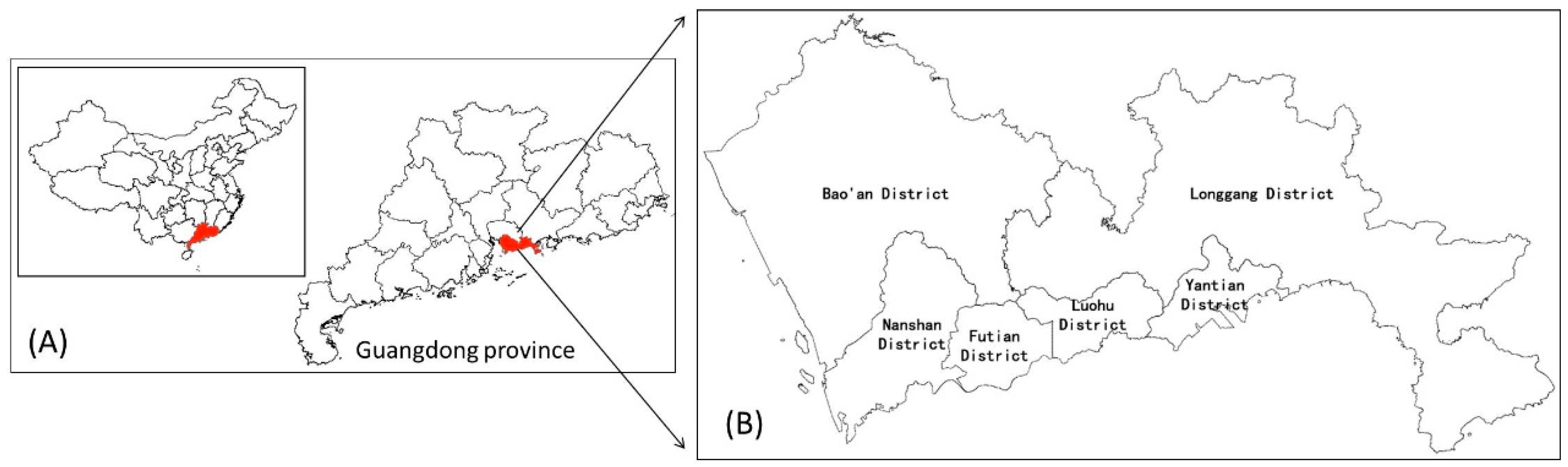
2. Study Area and Data

Shenzhen is located in southern Guangdong Province, China, and borders Hong Kong. Its administrative area is 1996 km2 (Figure 1). After being established as China’s first special economic zone in 1980, Shenzhen quickly developed from a sleepy small border town into a large modern city, quite impressive in the history of industrialization, modernization, and urbanization all over the world. From 1979 to 2014, the total population of Shenzhen has increased from 300,000 to 18 million [38] (far higher than the official number of 10.78 million), and its total Gross Domestic Product (GDP) has increased from 200 million yuan to 1.6 trillion yuan [39], as much as Hong Kong. Meanwhile, urban land has also expanded from 3 km2, when the Special Administrative Region was first established, to 968 km2, an expansion of more than 300-fold. However, the rapid development of Shenzhen’s social economy has far exceeded the sustainable supply capacity of resources. In 2005, in a government report, the government noted that Shenzhen was facing four “unsustainable” situations, specifically land, water resources, population, and the environment [40], of which land was considered the most important.
Figure 1. The location of the study area in China: (A) the location of Shenzhen in China; (B) Shenzhen administrative area map.
Sustainability 08 00016 g001
To analyze urban land expansion and spatial patterns in the study area, remote sensing images and land use surveys are used. Since 1995, The Urban Planning-Land & Resources Commission of Shenzhen Municipality (UPLRCSM) has carried out a land use survey each year. From the official channels we obtained land use survey results for 2005 and 2014. Restricted by technical conditions, the land use survey was not carried out in 1979 and 1986, so a Landsat Multispectral Scanner (MSS) and a Landsat Thematic Mapper (TM) images were selected. Then the construction land data were interpreted from the two remote sensing images. In fact, the results of the land use survey were also interpreted from the remote sensing images. Therefore, we think the construction land data for the four years were comparable. In addition, we have land conversion data, arable land data, and illegal construction data from the UPLRCSM. In order to compare with other cities in China, the data for GDP and fiscal revenue were collected from the Statistical yearbook in Shenzhen [41], Beijing [42], Shanghai [43], and Guangzhou [44]. The land-transferring fees data were collected from the Chinese Industry Research Network (http://www.chinairn.com).

3. Urban Land Expansion of Shenzhen

After the reform and opening up, Shenzhen developed rapidly due to the special economic zone policy advantages and the geographical advantage of being adjacent to Hong Kong. From 1979 to 2014, Shenzhen’s urban land expansion can be roughly divided into three stages.

3.1. 1979–1986

In the early stage of the reform and opening up, because of a lack of construction funds, the Shenzhen local government could only rely on the land resources to attract capital to invest in setting up factories. However, because the law at that time still prevented the buying and selling of land, three development models were adopted. The government commissioned tracts of land to other developers, utilized foreign funds to set up factories, or leased land to foreign-owned enterprises for development. Although the government only received a small amount of land use fees, it successfully developed the Shekou Industrial Zone, Nanyou, Overseas Chinese Town, and other development zones by relying on the aforementioned development approaches. During this period, the construction land increased from 3 km2 to 48 km2, with an average annual growth of 6.9 km2. Because transportation and location (i.e., distance from the ports) has a major influence on industry, the construction land was mainly concentrated in Luohu District and the two sides of Shennan Avenue and the Guangzhou–Shenzhen Highway (Figure 2B).
Figure 2. The evolution of Shenzhen construction land: (A) 1979; (B) 1986; (C) 2005; and (D) 2014.
Sustainability 08 00016 g002

3.2. 1987–2005

In 1987, Shenzhen led the country in implementing a land paid use system. Under the premise of retaining land ownership rights, the state relinquished land use rights to users by way of auctions, tenders, agreements, etc., for a certain price, tenure, and purpose [45]. This model solved the construction funding problems of the Shenzhen Special Economic Zone, and it also created a good investment environment. With the rapid development of an export-oriented economy via “Enterprises of Processing Industries and Compensation Trade” and “the three types of foreign-invested enterprises or ventures”, Shenzhen experienced an urban growth process based on rapid industrialization-driven urbanization. In 1984, the Shenzhen Government drafted the “Master Plan for Shenzhen Special Economic Zone (1986–2000)”. According to the document, Shenzhen was designed to be a megalopolis. Under the guidance of this plan, urban function and quality gradually improved, infrastructure such as transportation and municipal administration was gradually perfected, and urban land rapidly expanded. With increases in the floating population and the demand for housing after the start of the 1990s, the real estate industry developed rapidly and gradually became one of the core industries in Shenzhen and the main driver of urban land expansion. Meanwhile, an informal construction land expansion also occurred. Because the government expropriated a large quantity of rural land, there is no land available for local farmers to plant. They thus built factories and then leased them as a major source of income. As a consequence, labor-intensive industries attracted a large number of migrant workers, whose need for housing tempted local farmers to expand their private houses and rent them out [46]. In summary, due to the excessive pursuit of investment-driven economic growth and a loose environment for development, jointly pushed by both the formal and the informal land markets, land resources in Shenzhen were quickly consumed. During this period, urban land increased by 891 km2, and the average annual growth was 46.8 km2. The annual growth rate of construction land was 16.9%. In 2005, the construction land area in Shenzhen reached 939 km2, accounting for 47% of the total land area of the city, which exceeded the 20%–30% general ratio range of an international metropolis [47]. Natural conditions become the biggest determinants of spatial pattern in this rapid urban urbanization period. Until 2005, in addition to mountains, rivers, lakes, and other inappropriate construction areas, construction land has sprawled everywhere in the city (Figure 2C).

3.3. 2006–2014

The local government gradually apprehended the previous unsustainable land use patterns and started to change land use concepts and methods by using a variety of policy tools to suppress the expansion of urban construction land. During 2006–2014, when economic and population growth rates remained generally stable, the growth rate of urban construction land clearly decreased. The total urban construction land in 2014 was 968 km2. Compared with 2005, it only increased by 29 km2. The average annual growth was 3.2 km2. The annual increase was less than 1/15 that of the 1987–2005 period. The increase in urban construction land averaged an annual growth rate of only 0.3%, representing negligible growth. Urban land expansion was counteracted through the series of sustainable land use policy, including UGB, Establishment of Farmland Protection Areas, Urban Redevelopment, etc. Urban land expansion was counteracted and the construction layout then becomes more concentrated than sprawled (Figure 2D).

4. Policy Framework for Sustainable Land Use

In China, local government behavior is one of the most important drivers of urban land expansion [48,49,50]. In the 1990s, China implemented a tax system reform and re-divided powers and financial power between the central government and local governments, which strengthened the financial centralization capacity of the central government and caused a huge gap in local fiscal revenue and expenditure. Local governments had to raise their own funds to maintain economic growth; thus, land grant fees became the main source of fiscal revenue [51,52]. On the other hand, the existing performance appraisal system had always used GDP and fiscal revenue-based economic development indicators as the most important appraisal indicators for measuring the performance of the local government chief executive, further exacerbating the utility of local officials as the administrative decision-makers. However, local governments attracted investment, for example, by means of low-cost land grants, establishing development zones, and increasing GDP and employment. Furthermore, local governments implemented local infrastructure construction and provided public services through low-cost land expropriation and high-price land sales to obtain profits from the land to expand fiscal revenue, eventually leading to the massive growth of urban construction land [53,54]. The central government stood for the “public interests” of all citizens, stressed regional fairness and rational resource allocation, pursued the maximization of overall benefits for the economic-social-ecological environment and national food security, and strengthened the size control over cities ranked high in size. The central government used compulsory administrative orders to intervene in and regulate urban land expansion. These administrative methods include controlling the speed and scale of rural-to-urban land conversion in various cities, issuing arable land protection indices, and even requiring each major city to delineate a UGB. All these are the most basic means of controlling urban land expansion in China. However, due to the lack of theoretical support and the inability to meet regional development needs, the results of such top-down government policy tools were not as positive as expected [55]. Given the temptation of land revenue and achievements in urban development, local governments treated central index control negatively, even finding ways to cheat the central government [56,57]. The best example is as follows: Since 1997, the central government “froze the construction occupation of arable land”. In 1998, the country’s arable land decreased by 120 km2, although not all of this arable land was occupied by construction [58].
In summary, the decisions of most local governments to maximize their own self-interests reduce the overall interests of the entire society. Accordingly, overdevelopment beyond the social carrying capacity of the land and the irrational expansion of cities may occur. Relying solely on the central government’s mandatory and indicative mode of control over local governments to suppress the effects of urban land expansion has a very limited effect. When the Shenzhen government was faced with a land resource crisis, it built a new policy system. These policies, aimed at different objects and behaviors, have achieved certain results by using administrative, planning, economic, legal, and other means. Compared with a traditional management and control model, Shenzhen’s policy measures were more diverse and targeted (Figure 3).
Figure 3. Shenzhen sustainable land use policy system.
Sustainability 08 00016 g003

5. Shenzhen Practice and Results

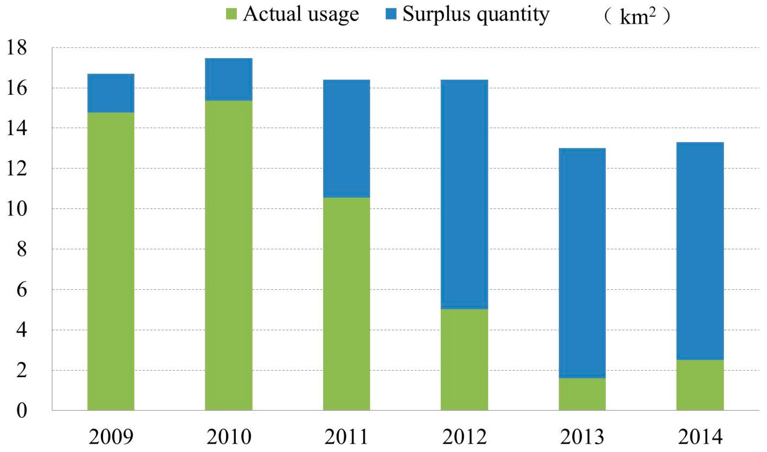
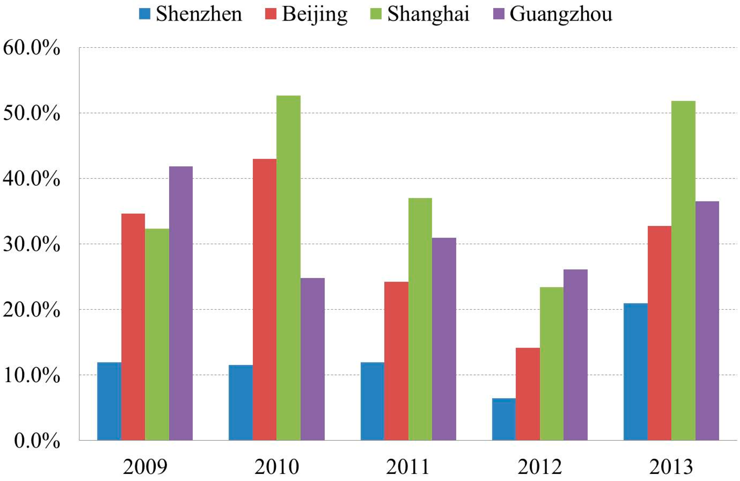
5.1. Reduction in Rural-to-Urban Land Conversion

Each year, based on the national economic situation, local natural endowments, and the urban development stage, the Central Government issues rural-to-urban land conversion indices to local governments to control the size of cities through index quotas [59,60]. These are especially strict for large cities. From 2009 to 2014, the central government issued a rural-to-urban land conversion quota of approximately 15 km2 to Shenzhen. However, the Shenzhen government has not used up all of its quota. Since 2009, Shenzhen’s rural-to-urban land conversion has gradually decreased. In 2013 and 2014, the size was not even 1/5 of the issued index (Figure 4). In China, in the process of converting agricultural land to construction land, obtaining land grant fees from land grants has been an important source of revenue for local governments [61,62]. From 2009 to 2013, Shenzhen has basically maintained land grant revenue ratios of less than 20%. Compared with Beijing, Shanghai, and Guangzhou—cities of approximately equal population and GDP—the ratio is at a lower level (Figure 5). The Shenzhen Municipal Government has gradually abandoned its dependence on land finances by reducing the size and speed of rural-to-urban land conversion.
Figure 4. The 2009–2014 rural-to-urban land conversion index for Shenzhen.
Sustainability 08 00016 g004
Figure 5. The ratio of land grant fees accounting for government revenues.
Sustainability 08 00016 g005

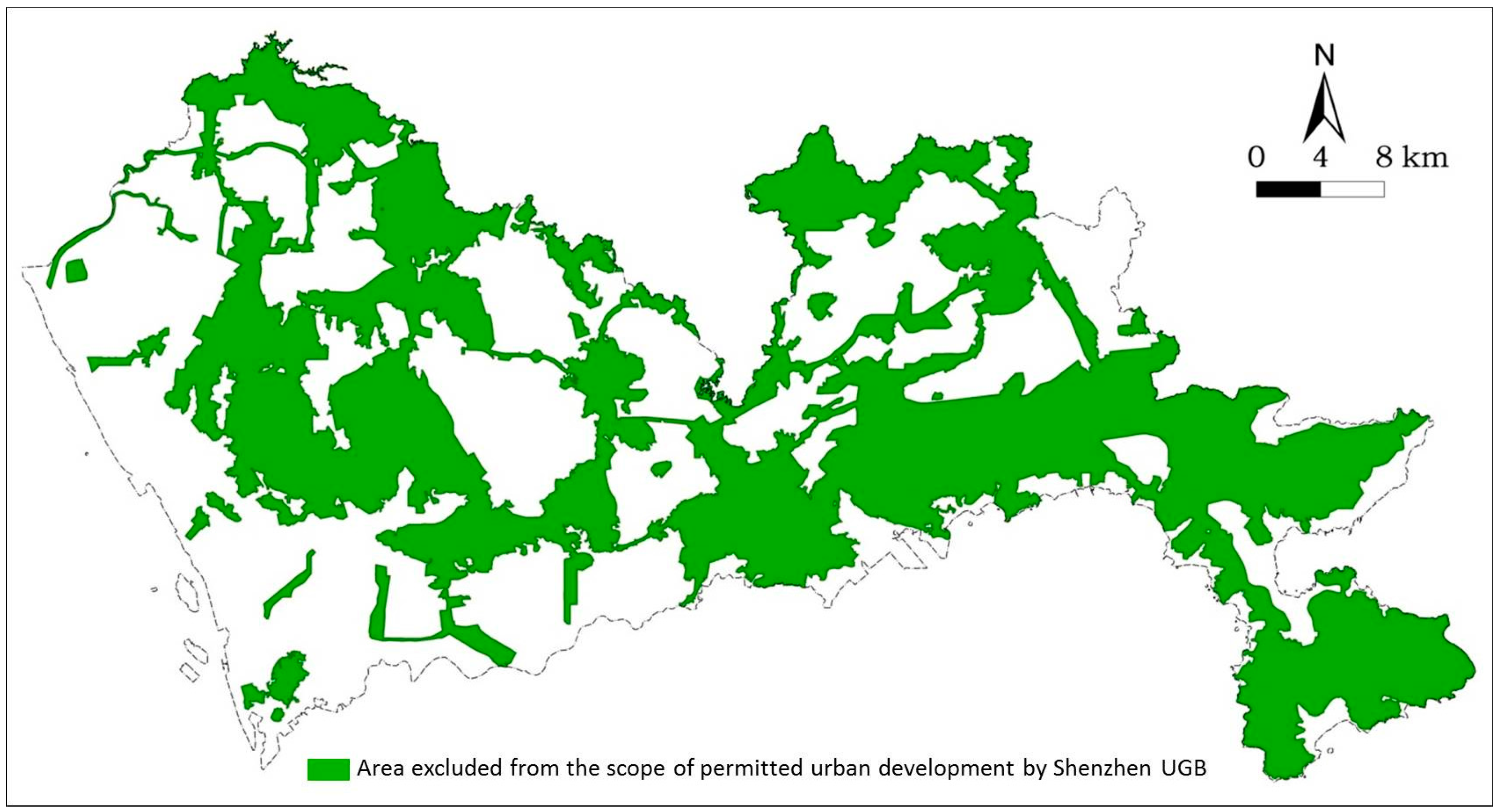
5.2. Urban Growth Boundary (UGB)

Rapid urban land expansion had led to a continued decline in the proportion of the city’s ecological areas and the loss of self-maintenance capabilities. The ratio of land covered by crops, forests, and grasslands in 2006 was 45.72%, whereas the ratio in 1996 was 51.36% [63]. In 2005, the Shenzhen government delineated a UGB that included first-order water source protection areas, nature reserves, farmland protection areas, and forests, in addition to country parks, mountains, rivers, reservoirs and wetlands, ecological corridors, and green spaces and islands, with a total of 974 km2 of land excluded from the scope of permitted urban development (Figure 6). The ratio of this area is nearly half the area of the entire city. The Government implemented strict building permits outside the scope of the UGB. Except for essential road transport infrastructure, public and tourism facilities, all other construction was banned.
Figure 6. Shenzhen UGB.
Sustainability 08 00016 g006

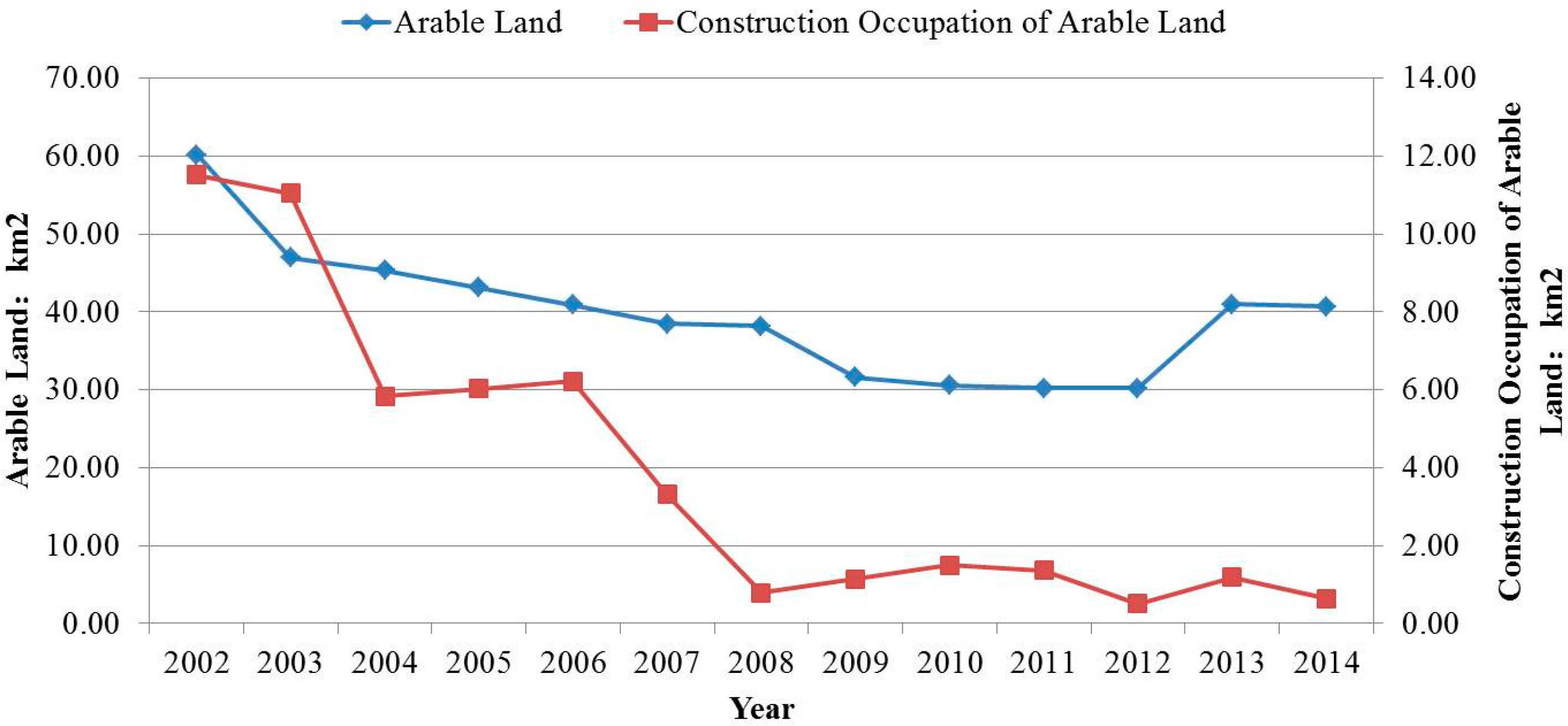
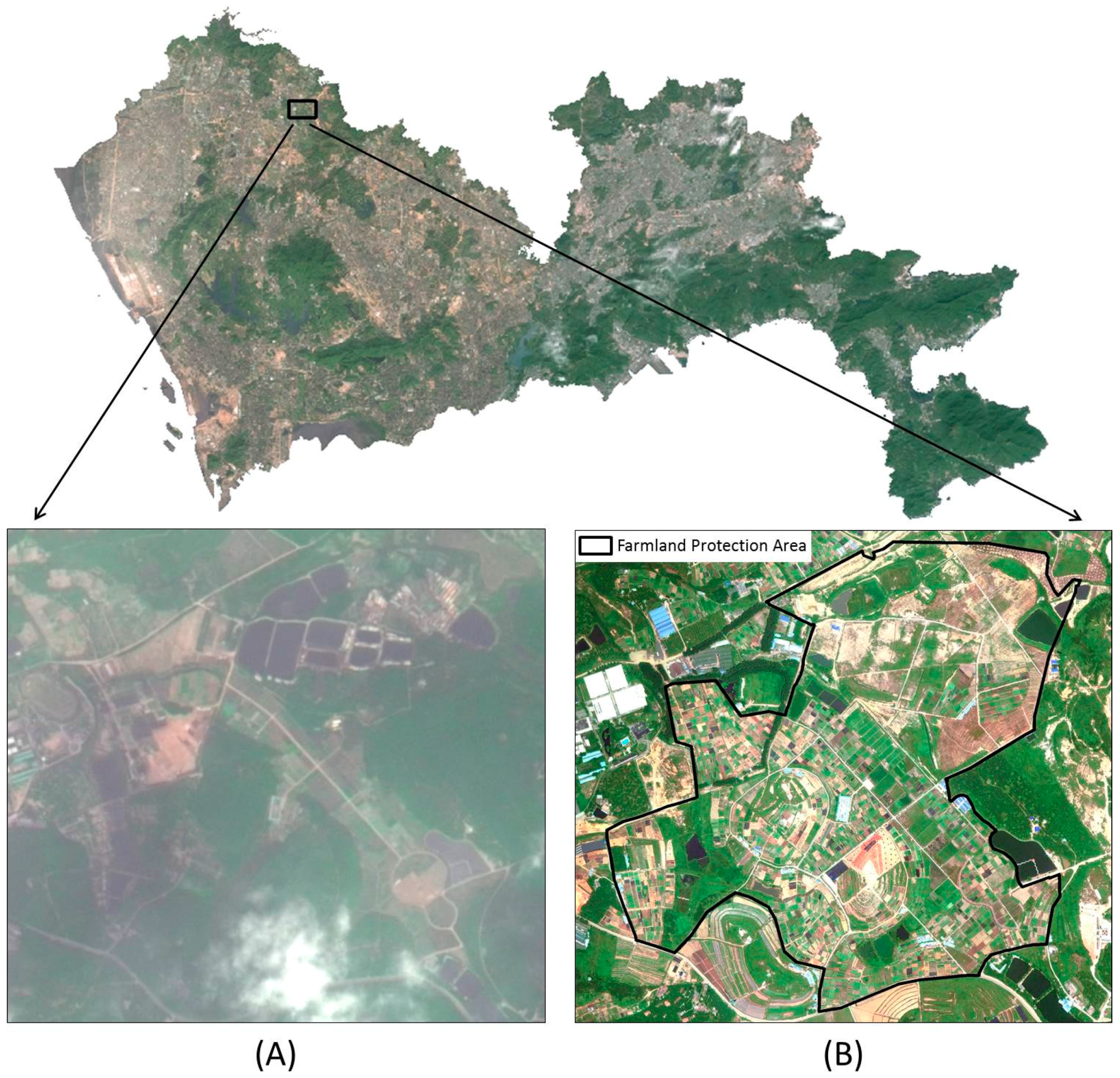
5.3. Arable Land Reclamation and the Establishment of Farmland Protection Areas

Rapid urban land expansion has also led to a considerable amount of erosion of arable land. From 1995 to 2009, the loss of arable land was up to 51.6%, and the net loss in the city’s arable land was 33.7 km2. Since 2009, the Shenzhen government has taken a series of measures to strengthen the protection of arable land. First, it optimized as much as possible the location selection of projects so as not to occupy arable land. From 2009 to 2014, Shenzhen’s annual mean occupation of arable land by construction was approximately 1 km2, only 1/10 that of 2002. The city’s loss of arable land is basically under control. Second, as the government has initiated arable land reclamation work in 2012, the area of arable land increased in 2013 (Figure 7). Third, it has delineated farmland protection areas by centralizing the distribution of the city’s farmland. Prior to 2010, Shenzhen’s arable land distribution was piecemeal, partly surrounded by urban land, and threatened by urban pollution. There were approximately 1500 parcels of arable land with areas of less than 400 m2. Scattered farmland not only reduces the efficiency of agricultural production but is also facing the risk of being annexed by cities at any time [64,65]. Since 2010, the Shenzhen government has planned 27 farmland protection areas, taking a land replacement approach to bring together scattered farmland tracts, which has both enhanced the efficiency of land use and allowed farmland protection areas to play a barrier role in urban land expansion (Figure 8).
Figure 7. The 2002–2014 total amount of arable land in Shenzhen and the status of the occupation of arable land by construction land.
Sustainability 08 00016 g007
Figure 8. A before-and-after comparison of a farmland protection area establishment: (A) before establishment; (B) after establishment.
Sustainability 08 00016 g008

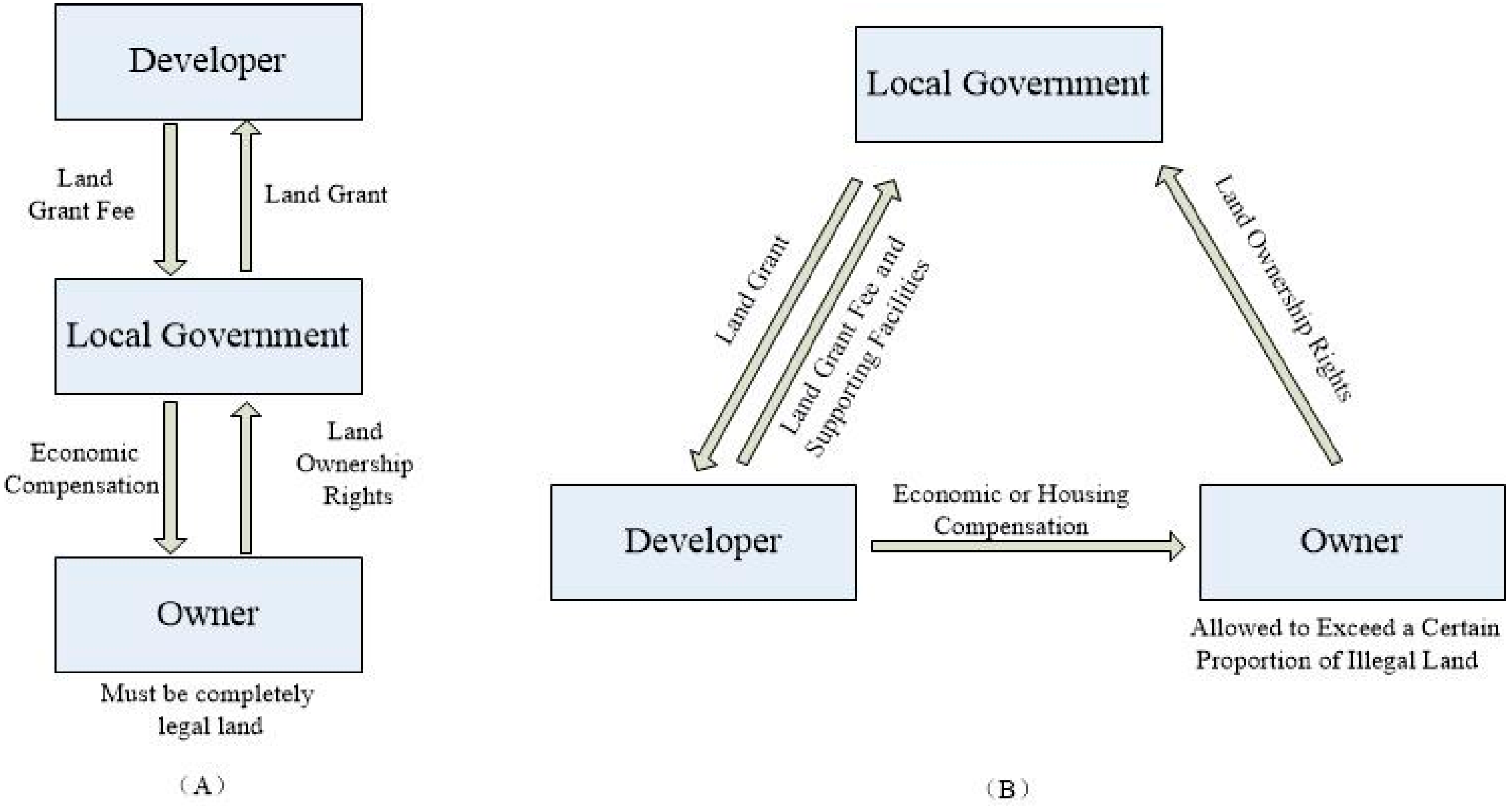
5.4. Urban Redevelopment

The urban redevelopment of old and inefficient built-up areas inside cities can provide better production space and living space and reduce the occupation of suburban farmland (Figure 9) [66,67]. After the land had been expropriated by the government, the farmers around the city could only build houses in the area delineated by the government and maintain their livelihood by leasing property. It thus formed a unique phenomenon—urban villages [68,69,70]. There were a total of 320 villages in the city, covering 93.49 km2 [71]. These villages in the city crisscrossed with the newly developed city and featured outdated functions, hidden security risks, and incomplete supporting facilities. They contrasted greatly with the metropolis and did not reflect proper land values [72,73]. From the perspective of improving a city’s quality, urban villages should become the area of focus for urban redevelopment. However, the various economic demands of owners within the urban villages and the huge costs of demolishing the mixed-in illegal buildings have caused the government to recoil at urban redevelopment [74]. Take the urban redevelopment of Gangxia urban village in 2009 as an example; because it is close to Shenzhen CBD, during the process of urban redevelopment, more than 20 billionaire families and 10 individual billionaires were created by the compensation. In China, currently, the local government is the only legitimate body of land expropriation [75,76]. Thus, developers cannot intervene before the land expropriation. They can only passively wait for the government to grant the land. To change this unidirectional method of land circulation, the Shenzhen government formulated policies in 2009 to encourage urban redevelopment. The biggest highlight of this policy was establishing a mechanism for coordinating the interests of the three parties—the government, developers, and owners. The developers led demolition talks, resettlement compensation, and other interest negotiation work; the government only formulated rules and served as an intermediate supervisor by enforcing related matters according to the contract after all parties had reached an agreement (Figure 10). In this process, the original owner land is converted into state-owned land (which cannot exceed a certain ratio of illegal land); the developers obtain land development rights and compensate the owners monetarily or with housing; and, meanwhile, the developers have to return to the government a certain ratio of supporting facilities, such as roads, primary schools, and kindergartens. This policy directs developers’ investment enthusiasm to the old town. In 2014, 30% of the entire city’s land grants came from urban redevelopment. The land grant premium reached 16.4 billion yuan, exceeding the total amount of 2008 land grant fees.
Figure 9. Urban redevelopment areas of Shenzhen.
Sustainability 08 00016 g009
Figure 10. A before-and-after comparison of Shenzhen’s urban redevelopment policy.
Sustainability 08 00016 g010

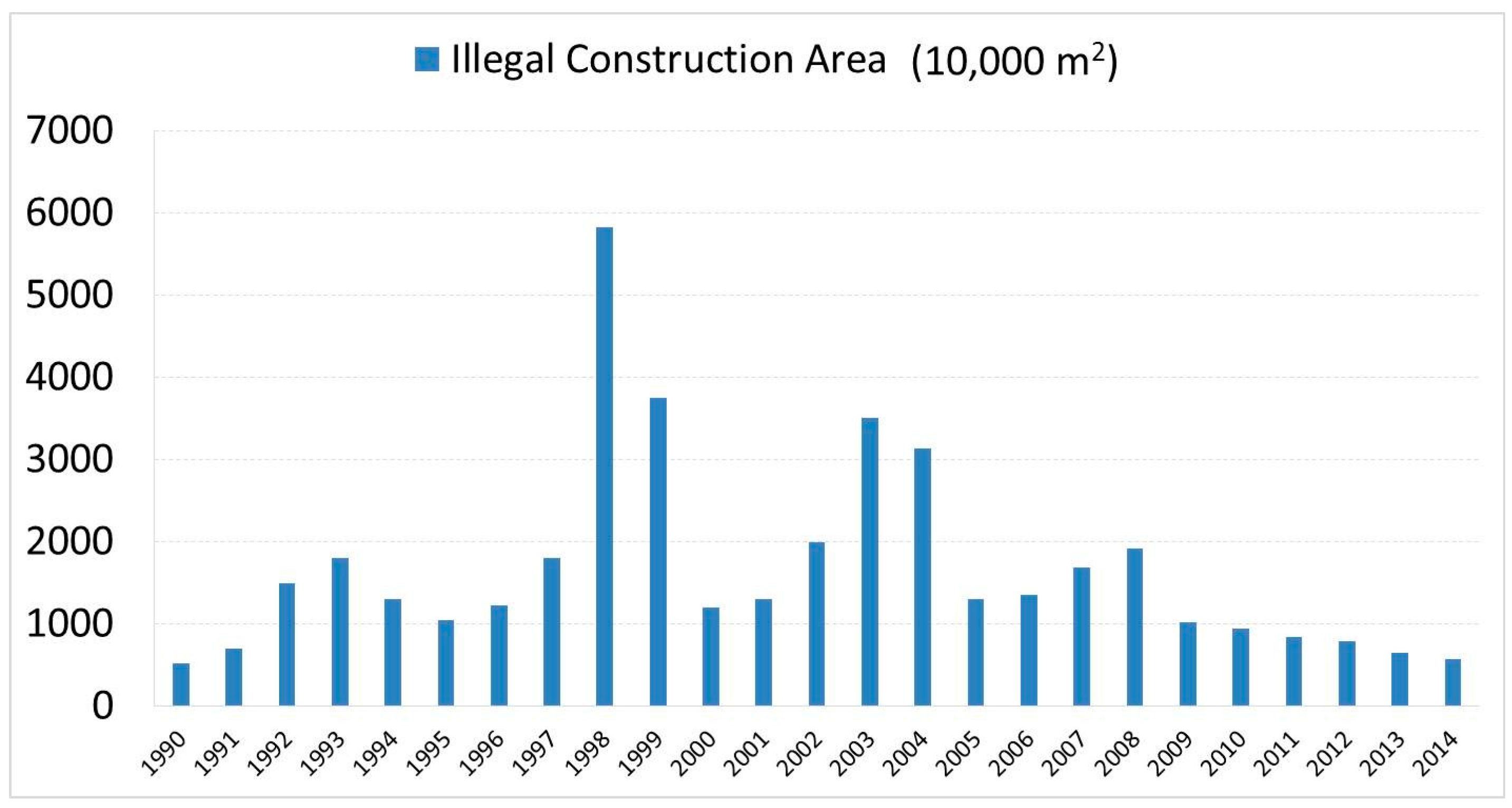
5.5. Investigation and Prosecution of Illegal Construction

As noted above, in the process of rapid urbanization in Shenzhen, the local farmers used informal and, strictly speaking, illegal methods to promote construction land expansion. They achieved two goals through wanton expansion or the construction of new homes. First, they obtained economic returns from leasing real estate. Second, they expected to obtain higher economic compensation in demolition talks with the government by means of this type of actual land occupation. Because these illegal buildings could improve the livelihood of local villagers and provide migrant workers with relatively inexpensive housing, the government adopted an ambiguous attitude toward these violations, leading to the development of large-scale illegal construction. Several times real estate market prosperity led to illegal building booms: in 1998, 2003, and 2008 (Figure 11). As of 2013, there were a total of 373,000 illegal buildings in Shenzhen. The building area was 428 million square meters, accounting for 43% of the total construction area. Furthermore, this was a unique situation countrywide [77,78].
In recent years, the Shenzhen government has realized that the proliferation of illegal construction has to be stopped, and demolition, confiscation, fines, and other measures against illegal land use have been used. Meanwhile, Remote Sensing Techniques, unmanned aerial vehicles, and other advanced technical means have been used to monitor violations, forming a highly effective control of illegal land use that has effectively inhibited local villagers’ speculative behavior and luck-oriented mindset. Under a strict punishment mechanism, informal urban sprawl and expansion have effectively been controlled. Since 2008, the average annual rate of decline in the city’s new illegal construction area has reached 12%. From 2010 to 2014, the total area of illegal land decreased by 213.75 hectares, an average annual decrease of 13.4% (Figure 11).
Figure 11. Shenzhen’s illegal construction areas in 1990–2014. Note: several times of real estate market prosperity led to illegal building booms: in 1993, 1998, and 2003. Since 2008, the illegal construction area has declined year after year.
Sustainability 08 00016 g011

6. Conclusions

From 1979 to 2014, Shenzhen’s urban land expansion has experienced three development stages. In the second to third stages of the transformation process, Shenzhen’s sustainable land use policy has played an extremely important role.
Compared with other countries, Shenzhen policies have their own characteristics. The concept and role of the Shenzhen UGB are basically similar to the UGB in the United States and the Greenbelt in the United Kingdom. Slight differences mainly lie in the following aspects: first, the Shenzhen UGB not only establishes an artificial boundary or “greenbelt” in the city’s outer ring but is also a boundary for ecological land protection; and second, due to the topography of Shenzhen, the shape of UGB is not a circle or a band but multiple closed sets of boundaries. As for the urban redevelopment policy, the main purpose in developed countries is to promote inner city revival and it is a process of city self-perfection. However, urban redevelopment policy in Shenzhen was proposed against a backdrop of high-speed urbanization; thus, the main purpose is to save land resources and enhance land use efficiency. Farmland protection policy, because of the different land property rights system, is mainly dominated by the market rules in developed countries, and the government only serves as a supervisor. In China, current arable land protection system is determined by the fertility and agricultural value of the land through a mandatory apportioning method that issues the country’s arable land holding tasks level by level down to the local governments [79]. Such measures likely generate great location choice constraints on urban development, affecting the overall efficiency of land resources [80]. Especially in Shenzhen, the value added by agriculture accounts for less than 0.1% of GDP. The ecological function of the cultivated land has clearly gone beyond food production. Shenzhen successfully combined national control requirements with actual local realities. The government initiated the reclamation of arable land and established farmland protection areas, which both accomplished the arable land tasks issued by the central government and led to improvements in local ecological quality.
The United Nations Development Program predicts that China’s urbanization rate will reach 70% by 2030 [81]. Some scholars, coming from an economic perspective, predict that the average year of maximum growth in China’s construction land will be approximately 2047 [82]. The additional implication is that a considerable amount of urban land expansion will continue to occur. However, urbanization is an irreversible human activity [83]. Allowing market mechanisms to dominate urban spatial growth may undermine non-renewable resources and a pleasant ecological environment. If proper measures and methods can be employed at present to suppress urban land expansion, it may be possible to circumvent the enormous challenges confronting sustainable urban development and the enormous costs that will be produced. Shenzhen’s policies can provide a reference and valuable lessons for other cities to explore sustainable land use.
First, Shenzhen government reduced the scale of rural-to-urban land conversion; it essentially changed the single-goal orientation in pursuit of economic interests and performance maximization into a composite orientation that also considered social, economic, and ecological benefits. Of course, a wide range of drivers was bound to exist in this transformation process, such as the scarcity of land resources, growing public ecological demands, etc. Shenzhen’s experience can direct rulers to make scientific and rational urban development goals, control the speed and strategy of rural-to-urban land conversion, and reduce the profit-drives and blindness of urban land expansion.
Second, other cities can learn from Shenzhen’s policies adopted in the fields of arable land and green space protection, urban redevelopment, illegal construction, and carrying out the planning and policy research according to the local situations. In fact, with the aid of experience in Shenzhen, the central government has demanded that 14 cities carry out the pilot work of UGB. However, there are huge differences between various cities in China. Each city is in a different development stage and faces different problems. An across-the-board management and control model cannot adjust to cities’ diverse states. Therefore, local governments should formulate sustainable land use policy according to the local realities.
Finally, as Ding [84] has stated, even the most upright official will have a strong incentive to play the role of a land developer, thereby converting agricultural land into urban land. The problems of the local government’s impulsivity, pursuit of profit, and blindness should be solved fundamentally. It is necessary to change the fiscal revenue and GDP-based assessment indicator and promotion mechanism for officials and establish a cadre performance evaluation mechanism that is based on guiding people’s livelihood and sense of wellbeing.

Acknowledgments

This study was supported by the National Natural Science Foundation of China (Project No. 41271455 and 41371427). The authors would like to thank Ren Fu from Wuhan University for their valuable suggestions. We also thank the Urban Planning, Land & Resources Commission of Shenzhen Municipality for providing the data and materials.

Author Contributions

Jing Qian conceived and designed the study with the support of Qingyun Du. All the co-authors drafted and revised the article together. All authors read and approved the final manuscript.

Conflicts of Interest

The authors declare no conflict of interest.

References

  1. China N.B.S. Statistical Communiqué of the People’s Republic of China on the 2014 National Economic and Social Development. Available online: http://www.stats.gov.cn/tjsj/zxfb/201502/t20150226_685799.html (accessed on 26 February 2015).
  2. The State Council. The New Urbanization Plan (2014–2020). Available online: http://www.gov.cn/gongbao/content/2014/content_2644805.htm (accessed on 9 December 2015).
  3. Freedmann, J. Four theses in the study of China’s urbanization. Int. J. Urban Reg. Res. 2006, 30, 440–451. [Google Scholar] [CrossRef]
  4. Gao, J.; Wei, Y.D.; Chen, W.; Yenneti, K. Urban Land Expansion and Structural Change in the Yangtze River Delta, China. Sustainability 2015, 7, 10281–10307. [Google Scholar] [CrossRef]
  5. Timberlake, M.; Wei, Y.D.; Ma, X.; Hao, J. Global cities with Chinese characteristics. Cities 2014, 41, 162–170. [Google Scholar] [CrossRef]
  6. Seto, K.C.; Kaufmann, R.K. Modeling the drivers of urban land use change in the Pearl River Delta, China: Integrating remote sensing with socioeconomic data. Land Econ. 2003, 79, 106–121. [Google Scholar] [CrossRef]
  7. Li, X.; Qu, F.; Zhang, S.; Zhang, S.; Wang, Y. Urban sprawl control in China based on international comparison and strategy selection. Trans. Chin. Soc. Agric. Eng. 2011, 27, 1–10. [Google Scholar]
  8. Qian, W. Market failure, government shortcoming and excessive expanding of land-use scales in China’s city. Econ. Geogr. 2001, 21, 456–460. [Google Scholar]
  9. Nelson, A.C.; Moore, T. Assessing growth management policy implementation: Case study of the United States’ leading growth management state. Land Use Policy 1996, 13, 241–259. [Google Scholar] [CrossRef]
  10. Bollens, S.A. State growth management: Intergovernmental frameworks and policy objectives. J. Am. Plan. Assoc. 1992, 58, 454–466. [Google Scholar] [CrossRef]
  11. Chinitz, B. Growth Management Good for the Town, Bad for the Nation? J. Am. Plan. Assoc. 1990, 56, 3–8. [Google Scholar] [CrossRef]
  12. Nelson, A.C. Comparing states with and without growth management analysis based on indicators with policy implications. Land Use Policy 1999, 16, 121–127. [Google Scholar] [CrossRef]
  13. Dempsey, J.A.; Plantinga, A.J. How well do urban growth boundaries contain development? Results for Oregon using a difference-in-difference estimator. Reg. Sci. Urban Econ. 2013, 43, 996–1007. [Google Scholar] [CrossRef]
  14. Bengston, D.N.; Fletcher, J.O.; Nelson, K.C. Public policies for managing urban growth and protecting open space: Policy instruments and lessons learned in the United States. Landsc. Urban Plan. 2004, 69, 271–286. [Google Scholar] [CrossRef]
  15. Knaap, G.J.; Hopkins, L.D. The inventory approach to urban growth boundaries. J. Am. Plan. Assoc. 2001, 67, 314–326. [Google Scholar] [CrossRef]
  16. Kühn, M. Greenbelt and Green Heart: Separating and integrating landscapes in European city regions. Landsc. Urban Plan. 2003, 64, 19–27. [Google Scholar] [CrossRef]
  17. Zhao, C.; Jin, G.; Zhou, P. Seoul’s expansion and South Korea’s urban development policy. Urban Probl. 2007, 1, 90–96. (In Chinese) [Google Scholar]
  18. Hayashi, K. Land readjustment in Nagoya. In Land Readjustment: A Different Approach to Financing Urbanization; Doebele, W., Ed.; Lexington Books: Lexington, KY, USA, 1982. [Google Scholar]
  19. Misra, B. Japanese experience in physical development and land management. In Transferability of Development Experience (Regional Development Dialogue, Special Issue 1984); Okita, S., Ed.; United Nations Centre for Regional Development: Nagoya, Japan, 1984. [Google Scholar]
  20. Henderson, S.; Bowlby, S.; Raco, M. Refashioning local government and inner-city regeneration: The Salford experience. Urban Stud. 2007, 44, 1441–1463. [Google Scholar] [CrossRef]
  21. Ponzini, D.; Rossi, U. Becoming a creative city: The entrepreneurial mayor, network politics and the promise of an urban renaissance. Urban Stud. 2010, 47, 1037–1057. [Google Scholar] [CrossRef]
  22. Duke, J.M.; Lynch, L. Farmland retention techniques: Property rights implications and comparative evaluation. Land Econ. 2006, 82, 189–213. [Google Scholar] [CrossRef]
  23. Nickerson, C.J.; Lynch, L. The effect of farmland preservation programs on farmland prices. Am. J. Agric. Econ. 2001, 83, 341–351. [Google Scholar] [CrossRef]
  24. Avin, U.; Bayer, M. Right-sizing Urban Growth Boundaries. Planning 2003, 69, 22–27. [Google Scholar]
  25. Howell-Moroney, M. Studying the effects of the intensity of US state growth management approaches on land development outcomes. Urban Stud. 2007, 44, 2163–2178. [Google Scholar] [CrossRef]
  26. Carruthers, J.I. The Impacts of State Growth Management Programmers: A Comparative Analysis. Urban Stud. 2002, 39, 1959–1982. [Google Scholar] [CrossRef]
  27. Hall, P. The containment of urban England. Geogr. J. 1974, 140, 386–408. [Google Scholar] [CrossRef]
  28. Nelson, A.C. Preserving prime farmland in the face of urbanization: Lessons from Oregon. J. Am. Plan. Assoc. 1992, 58, 467–488. [Google Scholar] [CrossRef]
  29. Gennaio, M.P.; Hersperger, A.M.; Bürgi, M. Containing urban sprawl—evaluating effectiveness of urban growth boundaries set by the Swiss Land Use Plan. Land Use Policy 2009, 26, 224–232. [Google Scholar] [CrossRef]
  30. Zhu, Z.; Yao, S.; Xu, G. Urban expansion and its spatial growth management in Nanjing. Hum. Geogr. 2003, 5, 11–16. (In Chinese) [Google Scholar]
  31. Chen, J.; Ren, L.; Yu, C.; Xu, X.; Li, X. Remarks on urban spatial growth management research. Plan. Stud. 2009, 10, 19–24. (In Chinese) [Google Scholar]
  32. Feng, K.; Wu, C.; Wei, S.; Liu, Y. Urban Expansion Management: Review on the Theory of UGB and its Reference for China. China Land Sci. 2008, 5, 77–81. (In Chinese) [Google Scholar]
  33. Liu, H.Y.; Zhang, P.G. Study on Application of Growth Management in Chinese Urban Planning. Urban Plan. Int. 2007, 22, 108–113. (In Chinese) [Google Scholar]
  34. Yang, H. Researches on the Law and Institutions for the Usage of Control of Land; Law Press: Beijing, China, 2010; pp. 212–214. [Google Scholar]
  35. Yu, B.; Lu, C. Change of cultivated land and its implications on food security in China. Chin. Geogr. Sci. 2006, 16, 299–305. [Google Scholar] [CrossRef]
  36. Tao, F.; Yokozawa, M.; Liu, J.; Zhang, Z. Climate change, land use change, and China’s food security in the twenty-first century: An integrated perspective. Clim. Chang. 2009, 93, 433–445. [Google Scholar] [CrossRef]
  37. Zou, Y.; Zhao, W.; Mason, R. Marketization of collective-owned rural land: A breakthrough in Shenzhen, China. Sustainability 2014, 6, 9114–9123. [Google Scholar] [CrossRef]
  38. Shenzhen Evening News. Shenzhen Carrying 18 Million People Currently. Available online: http://wb.sznews.com/html/2014–01/25/content_2765782 (accessed on 25 January 2014).
  39. Shenzhen N.B.S. Statistical Communiqué of Shenzhen on the 2014 National Economic and Social Development. Available online: http://www.sztj.gov.cn/xxgk/tjsj/tjgb/201504/t20150424_2862885.htm (accessed on 24 April 2015).
  40. Futian Government Online. The Government Work Report 2005. Available online: http://www.southcn.com/news/dishi/shenzhen/ggl/200506060358.htm (accessed on 6 June 2005).
  41. Shenzhen Statistical Yearbook (2014). Available online: http://www.sztj.gov.cn/nj2014/start2014.htm (accessed on 31 March 2015).
  42. Beijing Statistical Yearbook (2014). Available online: http://www.bjstats.gov.cn/nj/main/2014-tjnj/CH/index.htm (accessed on 23 December 2015).
  43. Shanghai Statistical Yearbook (2014). Available online: http://www.stats-sh.gov.cn/data/toTjnj.xhtml?y=2014 (accessed on 25 September 2015).
  44. Guangzhou Statistical Yearbook (2014). Available online: http://data.gzstats.gov.cn/gzStat1/chaxun/njsj.jsp (accessed on 7 April 2015).
  45. Ng, M.K. Shenzhen. Cities 2003, 20, 429–441. [Google Scholar] [CrossRef]
  46. Hin, L.L.; Xin, L. Redevelopment of urban villages in Shenzhen, China–an analysis of power relations and urban coalitions. Habitat Int. 2011, 35, 426–434. [Google Scholar] [CrossRef]
  47. Shi, Y.; Peng, Z.; Chen, H.; Chen, Y.; Fan, H. Features of land use change and impact factors of construction land of international metropolises and significances to Shanghai. Urban Plan. Forum 2008, 6, 32–39. [Google Scholar]
  48. Huang, Z.; Wei, Y.D.; He, C.; Li, H. Urban land expansion under economic transition in China: A multi-level modeling analysis. Habitat Int. 2015, 47, 69–82. [Google Scholar] [CrossRef]
  49. Li, H.; Wei, Y.D.; Liao, F.H.; Huang, Z. Administrative hierarchy and urban land expansion in transitional China. Appl. Geogr. 2015, 56, 177–186. [Google Scholar] [CrossRef]
  50. Wei, Y.D. Restructuring for growth in urban China: Transitional institutions, urban development, and spatial transformation. Habitat Int. 2012, 36, 396–405. [Google Scholar] [CrossRef]
  51. Tang, B.; Wong, S.; Liu, S. Institutions, property taxation and local government finance in China. Urban Stud. 2011, 48, 847–875. [Google Scholar] [CrossRef]
  52. Qun, W.; Yongle, L.; Siqi, Y. The incentives of China’s urban land finance. Land Use Policy 2015, 42, 432–442. [Google Scholar] [CrossRef]
  53. Ding, C. Policy and praxis of land acquisition in China. Land Use Policy 2007, 24, 1–13. (In Chinese) [Google Scholar] [CrossRef]
  54. Guo, S.; Liu, L.; Zhao, Y. The business cycle implications of land financing in China. Econ. Model. 2015, 46, 225–237. [Google Scholar] [CrossRef]
  55. Long, Y.; Han, H.; Lai, S.K.; Mao, Q. Urban growth boundaries of the Beijing Metropolitan Area: Comparison of simulation and artwork. Cities 2013, 31, 337–348. [Google Scholar] [CrossRef]
  56. Guo, G.C.; Wu, Q. On System Obstruction of Cultivated Land Protection in China from the Viewpoint of Principal- agent Theory. China Land Sci. 2008, 4, 49–55. (In Chinese) [Google Scholar]
  57. Chen, H.; Wu, Y.; Ou, M. Theoretical Construction of Compensation Mechanism for Farmland Protection. J. Nanjing Agric. Univ. 2009, 9, 67–71. (In Chinese) [Google Scholar]
  58. Shan, Y.; Yang, L.; Wang, J. Economic analysis of loss of cultivated land in China. Syst. Sci. Compr. Stud. Agric. 2002, 18, 300–303. (In Chinese) [Google Scholar]
  59. Jin, X.; Shen, Z. The Cap-and-trade Model of Incremental Construction Land Quota: An Analog with the Emission Permits System. China Popul. Resour. Environ. 2010, 20, 86–91. (In Chinese) [Google Scholar]
  60. Jin, X.M. Market-oriented Reform of Administration in Incremental Construction Land Quota. China Land Sci. 2009, 23, 19–23. (In Chinese) [Google Scholar]
  61. Zheng, H.; Wang, X.; Cao, S. The land finance model jeopardizes China’s sustainable development. Habitat Int. 2014, 44, 130–136. [Google Scholar] [CrossRef]
  62. Tian, L. Land use dynamics driven by rural industrialization and land finance in the peri-urban areas of China: “The examples of Jiangyin and Shunde”. Land Use Policy 2015, 45, 117–127. [Google Scholar] [CrossRef]
  63. Shenzhen City Planning and Land Resources. The Comprehensive Planning of Shenzhen City (2010–2020). Available online: http://www.szpl.gov.cn/ (accessed on 29 September 2010).
  64. Orea, L.; Perez, J.A.; Roibas, D. Evaluating the double effect of land fragmentation on technology choice and dairy farm productivity: A latent class model approach. Land Use Policy 2015, 45, 189–198. [Google Scholar] [CrossRef]
  65. Latruffe, L.; Piet, L. Does land fragmentation affect farm performance? A case study from Brittany, France. Agric. Syst. 2014, 129, 68–80. [Google Scholar] [CrossRef]
  66. Zheng, H.W.; Shen, G.Q.; Wang, H.; Hong, J. Simulating land use change in urban renewal areas: A case study in Hong Kong. Habitat Int. 2015, 46, 23–34. [Google Scholar] [CrossRef]
  67. Donaldson, R.; du Plessis, D. The urban renewal programmer as an area-based approach to renew townships: The experience from Khayelitsha’s Central Business District, Cape Town. Habitat Int. 2013, 39, 295–301. [Google Scholar] [CrossRef]
  68. Tong, D.; Feng, C.C.; Li, G.C.; Chen, P. Categories and characteristics of urban villages by GIS-based analysis: A case study of the Shenzhen Special Economic Zone. Sci. China Technol. Sci. 2010, 53, 150–157. [Google Scholar] [CrossRef]
  69. De, T.; Changchun, F.; Jin, J.D. Spatial evolution and cause analysis of urban villages: A case study of Shenzhen Special Economic Zone. Geogr. Res. 2011, 30, 437–446. [Google Scholar]
  70. Song, Y.; Zenou, Y. Urban villages and housing values in China. Reg. Sci. Urban Econ. 2012, 42, 495–505. [Google Scholar] [CrossRef]
  71. Hao, P.; Sliuzas, R.; Geertman, S. The development and redevelopment of urban villages in Shenzhen. Habitat Int. 2011, 35, 214–224. [Google Scholar] [CrossRef]
  72. Wang, Y.P.; Wang, Y.; Wu, J. Urbanization and informal development in China: Urban villages in Shenzhen. Int. J. Urban Reg. Res. 2009, 33, 957–973. [Google Scholar] [CrossRef]
  73. Liu, Y.; He, S.; Wu, F.; Webster, C. Urban villages under China’s rapid urbanization: Unregulated assets and transitional neighborhoods. Habitat Int. 2010, 34, 135–144. [Google Scholar] [CrossRef]
  74. Lai, Y.; Peng, Y.; Li, B.; Lin, Y. Industrial land development in urban villages in China: A property rights perspective. Habitat Int. 2014, 41, 185–194. [Google Scholar] [CrossRef]
  75. Wang, Q.; Zhang, X.; Wu, Y.; Skitmore, M. Collective land system in China: Congenital flaw or acquired irrational weakness? Habitat Int. 2015, 50, 226–233. [Google Scholar] [CrossRef]
  76. Ding, C. Land policy reform in China: Assessment and prospects. Land Use Policy 2003, 20, 109–120. [Google Scholar] [CrossRef]
  77. Ye, W. The Analysis on the Illegal Building in Urban Village in Shenzhen. China Bus. Mark. 2011, 25, 69–72. (In Chinese) [Google Scholar]
  78. Comprehensive Research Group, National School of Development, Peeking University. Market solutions to urban redevelopment—A study on shenzhen’s land reform. Int. Econ. Rev. 2014, 3, 56–71. [Google Scholar]
  79. Zhang, X.; Ou, M.; Li, J. Analysis on the Institution Change of Cultivated Land Protection and Its Performance in China. Soc. Sci. 2007, 8, 13–20. (In Chinese) [Google Scholar]
  80. Tang, H.; Yun, W.; Guan, X.; Liang, M. Farmland Utilization in Big Cities must Be Based on National Spatial Service. Nat. Resour. Econ. China 2015, 28, 11–13. (In Chinese) [Google Scholar]
  81. Sustainable and Livable Cities: Toward Ecological Civilization. Available online: http://rcid.cau.edu.cn/art/2013/12/2/art_7631_229156.html (accessed on 2 December 2013).
  82. Li, X.; Zhang, S.; Wang, Y. Quantitative Study of Construction Land Increase Limit Year in the Economic Transition Stage in China. J. Nat. Resour. 2011, 26, 1085–1095. (In Chinese) [Google Scholar]
  83. Seto, K.C.; Fragkias, M.; Güneralp, B.; Reilly, M.K. A meta-analysis of global urban land expansion. PLoS ONE 2011, 6, e23777. [Google Scholar] [CrossRef] [PubMed]
  84. Ding, C. Urban Growth and Policy: International Perspective and China Development; Higher Education Press: Beijing, China, 2009; pp. 283–290. [Google Scholar]

