Review

A Mapping of Tools for Informing Water Sensitive Urban Design Planning Decisions—Questions, Aspects and Context Sensitivity

by
Sara Maria Lerer
*,
Karsten Arnbjerg-Nielsen
and
Peter Steen Mikkelsen
Department of Environmental Engineering (DTU Environment), Technical University of Denmark, Miljøvej, Building 113, Lyngby DK-2800, Denmark
*
Author to whom correspondence should be addressed.
Water 2015, 7(3), 993-1012; https://doi.org/10.3390/w7030993
Submission received: 19 November 2014 / Revised: 13 February 2015 / Accepted: 25 February 2015 / Published: 11 March 2015
(This article belongs to the Special Issue Sustainable Drainage Systems)

Abstract

:
Water Sensitive Urban Design (WSUD) poses new challenges for decision makers compared with traditional stormwater management, e.g., because WSUD offers a larger selection of measures and because many measures are multifunctional. These challenges have motivated the development of many decision support tools. This review shows that the tools differ in terms of the types of questions they can assist in answering. We identified three main groups: “How Much”-tools, “Where”-tools and “Which”-tools. The “How Much”-tools can further be grouped into tools quantifying hydraulic impacts, hydrologic impacts, water quality impacts, non-flow-related impacts and economic impacts. Additionally, the tools differ in terms of how many aspects of water they address, from those focused only on bio-physical aspects to those attempting to find the best WSUD based on multiple criteria. Finally, we suggest that variability among the tools can partly be explained by variability in local context including conditions such as type of existing stormwater systems, groundwater conditions and legislative frameworks.

Graphical Abstract

1. Introduction

The concept of Water Sensitive Urban Design has received increased interest in recent years. Some of the drivers include climate change and urbanization. These two factors, alone and combined, are causing an intensification of the adverse environmental impacts of traditional urban drainage systems, and are expected to increasingly do so in the future [1,2]. Therefore many scientists and other professionals are looking for other means of managing urban stormwater that fit into the urban environment and that lower the adverse impacts on the natural and built environment while maintaining the hygienic barriers between humans and polluted water [3,4].
A multitude of new terms for stormwater management has consequently emerged in the past decades including Sustainable Urban Drainage Systems (SUDS), Stormwater Best Management Practices (BMPs), Green Infrastructure (GI), Low Impact Development (LID), and Water Sensitive Urban Design (WSUD) [5]. We here use the term WSUD to describe any installation or intervention in the urban space that can manage stormwater (through detention, harvesting, infiltration, evaporation or transport) while contributing with some added functionality (such as recreational value, urban heat island mitigation, traffic control, etc.), although we acknowledge that multifunctionality is reflected to variable degrees in the different terms that are to some extent used interchangeably in the literature.
The practical experience with implementing WSUD is sparse in many regions, especially compared with the century long experience with traditional piped systems. Therefore many knowledge gaps need to be filled before large scale implementation of WSUD can be expected. Another factor that inhibits implementation of WSUD is the increased complexity compared with pipe-based systems, due to the fact that WSUD becomes an integrated part of the urban landscape rather than a distinct functionality hidden underground, a part that also takes up space (which is a valuable resource in dense cities). WSUD also has impacts on parts of the urban water cycle that are usually not considered important when assessing pipe-based systems, such as groundwater.
Not surprisingly, many tools have been developed to assist making decisions regarding the implementation of WSUD. In this context, we consider a decision support tool to be any software tool that can answer a question the decision maker asks, i.e., provides information that is relevant for the decision in a manner that is clear and manageable. Hence, a decision support tool may focus on visualizing already existing information or on producing new information based on analysis of input information.
Several recent review papers have addressed the subject of WSUD and decision support. Zhou [6] offered a comparison of modelling approaches and a classification of other decision-aid tools, focusing on tools supporting the overall aim of assessing sustainability. Bach et al. [7] reviewed tools for modelling the broader scope of integrated urban water systems. Blumensaat et al. [8] compared and discussed a variety of protocols for water quality impact assessment. Jayassooriya and Ng [9] focused on tools for making cost-benefit analysis. All these reviews contribute valuable information, but none of them provide a complete overview of all the tools available to assist a decision maker considering implementing WSUD in an existing urban area.
The main aim of this paper is to provide an overview of the decision support tools available to decision makers when considering implementation of WSUD, illustrating the tools’ capabilities and limitations. We provide this overview by two means:
  • A categorization based on the main functionality of the tools, i.e., what questions they can help answer,
  • An evaluation of which aspects of the complex subject of “water” the different types of tools address.
Furthermore, we reflect on how the differences among tools correspond to different local contexts of decision making.
The paper is structured as follows. In Section 2, Methods, we describe our literature search strategy, the approach used for categorization, the theory of aspects of water and the assumption of context dependency. In Section 3, Results and Discussion, we present the functional categories identified, describe selected tools to exemplify the functionalities, show what aspects of water are addressed by the tools, offer some reflections on the context dependency of the tools, and finally discuss the limitations of our study and some perspectives for future work. In Section 4, Conclusions, we summarize our findings.

2. Methods

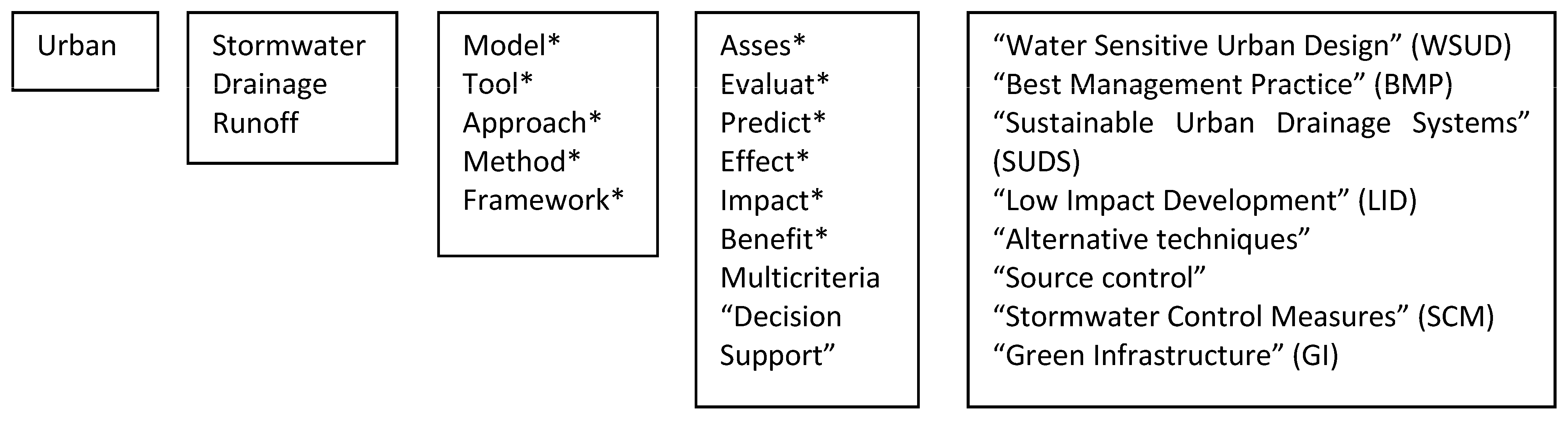
2.1. Literature Search

The tools reviewed were mainly found by searching for papers using the search engine and databases of Web of Science. The search phrase we used is illustrated in Figure 1. In addition to this search, some papers were found through reference lists of other papers and based on the authors’ personal experience. In this paper, we generally use the term WSUD, but when citing other papers we use the term used by the original authors (such as SUDS or LID). In doing so, we assume a substantial overlap in the meanings conveyed by the different terms [5], accepting that some of the other terms may not necessarily include the multifunctionality implied by the term WSUD.
Figure 1. Illustration of the search phrase used in this study. The boxes are connected with “AND” while words within a box are connected with “OR”. An asterisk (*) represents a wildcard.
Water 07 00993 g001

2.2. Categorization Based on Questions Addressed by the Tools

We found that the tools are different from each other in many ways yet overlapping in other ways, and no set of categories could place them in mutually exclusive boxes. We reasoned that the primary concern of a decision maker when choosing a decision support tool would be whether this tool could assist in answering a set of questions that were identified as important to address for making a well-informed decision. We hence identified the most common questions that the tools we found may assist in answering, and designed a logical structure that sorts the different questions into groupings and sub-groupings.

2.3. Characterisation Based on Aspects of Water Valued by Stakeholders

Aspects of water is a methodology for mapping perceptions and values in urban stormwater management [10]. We used these aspects to characterize a selection of tools as another way of revealing their different focus areas. The aspects of water are a further development of the aspects theory developed by the Dutch philosopher Dooyewerd [10]. Dooyewerd used 15 aspects, ranked in order of importance, to describe the richness and multifacetedness of reality. The lower aspects obey the laws of nature, and may also be described as bio-physical aspects. The upper aspects affect how people deal with nature, and may also be described as human aspects. Valkman et al. [10] reduced the number of aspects to 12, including only three aspects in the bio-physical domain and omitting the highest aspect (pistic), see Table 1. They applied these aspects to water and suggested using them as a framework for drawing a complete picture of stormwater related issues, uncovering the different perspectives among stakeholders which are not water professionals. A slightly modified version of the aspects of water was later used by Fratini et al. [11] to analyse which issues were prioritized by different groups of stakeholders when interviewed about the same projects Their results indicate that water professionals need to learn how to extend their scope of aspects in order to create projects valued by a wider range of stakeholders.
Table 1. The 12 aspects of water used in our analysis, adapted from Valkman et al. [10].
AspectEssenceIn Relation to Urban Water, with Specific Examples
Human Aspects
12. MoralViews concerning good treatmentViews concerning good water management
  • Safety, or the prevention of damage
  • Sustainability
11. LegalLawRegulations for water
  • Issue of permits for sewer overflow
10. AestheticBeautyThe beauty of water
  • Reflecting water
  • Sunset by the sea
9. EconomicWay of savingEconomic water management
  • Do the costs of water projects weigh up against the benefits/values?
  • No wastage of groundwater
8. SocialDealing with peopleMeeting by the water
  • Discussion by the drinking water well in Africa
  • Resident evening concerning disconnection project
7. LinguisticSymbolic significanceWriting about water
  • Poems
  • Water leaflet
6. HistoricalManagement by free formingIntervention in the water system
  • Land reclamation
  • Delta works
5. Logical Analytical distinctionThinking about water
  • Thales: “Everything is water”
  • Organizing the water chain
4. PsychologicalPerceptionWater stimulates the senses
  • Water is wet
  • Delicious drinking water
Bio-Physical Aspects
3. BioticLife processesWater as the first condition for life
  • A person can survive for a maximum of 3 days without water
  • Fish live in water
2. ChemicalMatterWater carries other substances
  • Water quality parameters
1. PhysicalUninterrupted extendedness, uniform movementWater occupies space and water flows
  • a pond contains a quantity of water
  • water flows with gravity in unpressured pipes

2.4. Context Dependency

The large variation we found among the tools encouraged us to consider how the local context has shaped each tool by helping to answer the questions that were deemed urgent by the tool developers at a given time and place. We based our analysis on the findings of the literature search coupled with our research experience and practical experience with WSUD projects.

3. Results and Discussion

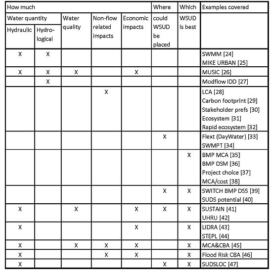
3.1. Categorization Based on Questions Addressed by the Tools

The structure that emerged from analysing what types of questions the different tools can help answer is shown in Table 2. On the highest level there are three types of questions: “How Much”, i.e., tools that provide quantitative answers, “Where”, i.e., tools that provide spatial answers, and “Which”, i.e., tools that help choose among options. The “How Much” category is further divided into tools that quantify different types of impacts: impacts related to hydraulics, i.e., the flow of water through pipes and across surfaces, impacts related to hydrology, i.e., the flow of water through the entire urban water cycle including groundwater and the atmosphere, impacts related to water quality, i.e., the pollution carried with water, impacts that are not directly linked to the flow of water (such as aesthetics and recreation), and economic impacts.
Table 2. The headings of this table present a structure for categorizing types of questions answered by WSUD decision support tools. The right column contains examples of tools that are further described in the following sections. The tools are grouped (indicated by the horizontal lines) according to which types of questions they may help in answering (indicated by the Xs).
How MuchWhereWhichExamples Covered in This Review
Water QuantityWater QualityNon-Flow related ImpactsEconomic ImpactsCould WSUD Be PlacedWSUD Is Best
HydraulicHydrologic
XX SWMM [24]
MIKE URBAN [25]
XXX X MUSIC [26]
X Modflow IDD [27]
X LCA [28]
Carbon footprint [29]
Stakeholder preferences [30]
Thorough ecosystem [31]
Rapid ecosystem [32]
X Flext (DayWater) [33]
SWMPT [34]
XBMP MCA [35]
BMP DSM [36]
Project choice [37]
MCA/cost [38]
XXSWITCH BMP DSS [39]
SUDS potential [40]
X X XXXSUSTAIN [41]
UHRU [42]
X X XLIDRA [43]
STEPL [44]
X XXX XMCA&CBA [45]
X XX XFlood Risk CBA [46]
X XXSUDSLOC [47]
When going through our search results we focused more on water quantity issues than water quality, and hence tools that focus on water quality were omitted. For examples of tools with specific focus on water quality issues, see e.g., [12,13,14]. We also omitted tools that focus on the broader issue of integrated urban water management, although some of these tools include functionality that is similar to the categories defined here; for examples of such tools see e.g., [15,16,17,18]. Finally, we also omitted process support tools, i.e., tools that provide a framework for a decision making process rather than providing concrete information to be used in such a process; for examples of such tools, see e.g., [19,20,21,22,23].
Note that some tools that provide the same functionality (i.e., answer the same questions) may do so with different methods, which may vary greatly in terms of input requirements, software requirements, expertise required of intended users and overall complexity. We have included a few different examples of tools in each category (listed in the rightmost column of Table 2) in order to describe some of this variability, but in order to preserve clarity, we have not attempted to cover all the variability in this review.
The following sections offer descriptions of examples of tools within each of the functional categories as well as some examples of tools that combine several types of functionality.

3.1.1. “How Much Water”-Tools

Hydraulic and hydrologic models generally answer interrelated questions such as “How Much Water, Where and When”, by transforming rainfall data into surface and subsurface flows and storages, and routing these flows through representations of natural and technical systems such as pipes, basins, rivers and groundwater reservoirs. For a thorough review on different types of hydraulic and hydrologic models, please refer to Zoppou [48]. Elliot and Trowsdale [49] provided a thorough review of how well 10 of the more popular modelling tools enable representations of LID technologies such as swales and rainwater tanks. They documented that the models differ in terms of temporal and spatial resolution, whether they include a groundwater component, how many contaminants can be modelled, which LID devices are included explicitly, and whether they incorporate GIS (Geographical Information System) and other graphical interface features. They conclude that none of the models are intended for the full spectrum of uses that could be demanded in relation to LID, and that there is considerable scope for improving their capabilities. Seven years later, Fletcher et al. [50] noted that an important gap remains between models which allow assessment of hydraulic impacts at the network and catchment level, and models that represent source control measures well but are unable to predict their impact on catchment level, and that the integration of these scales remains a question for further research.
A recent example of applying a traditional stormwater model to a BMP implementation case is given by Petrucci et al. [24]. Their study included modelling the hydraulic impacts of implementing rainwater tanks in a Parisian suburb using SWMM5. As noted by Elliot and Trowsdale [49], rainwater tanks are not explicitly included in SWMM but can be modelled indirectly; in this case the rainwater tanks were represented in the model using the initial loss parameter, which was set to vary so that it represents the expected available space for storage as a function of filling by rainfall and emptying by evapotranspiration (representing usage of the stored water for garden watering).
An example of improving a traditional stormwater model to better represent WSUD is given by Roldin et al. [25]. They presented a methodology to estimate the impacts of extensive stormwater infiltration including a new module for dynamical modelling of soakaways in MIKE URBAN CS (formerly MOUSE). They applied the methodology to an urban catchment in Greater Copenhagen, studying three scenarios: baseline, full spatial potential implementation of soakaways and realistic implementation of soakaways limited by rising groundwater tables. The two latter scenarios were each modelled both using the dynamic soakaway module and a simplification where the impervious area routed to soakaways was completely disconnected from the stormwater model. Their results showed that simplifying the soakaways by removing the impervious areas from the model produced similar results to using the dynamic module; however, this was attributed to the relatively large volumes of the soakaways, resulting in few overflows to the sewer system.
By contrast to the stormwater models mentioned above (SWMM5 and MIKE URBAN), MUSIC was developed explicitly to represent WSUD elements and assess their impact on stormwater quality and hydrology [50]. An example application of MUSIC to compare the hydrological impacts of conventional stormwater management versus flow-regime management is given by Burns et al. [26]. They showed that catchments managed with focus on drainage efficiency or load reduction result in streamflows very different from an undeveloped catchment. In contrast, a management strategy focused on flow regime, using a combination of rainwater tanks and rain gardens, successfully reduced the frequency, magnitude and volume of stormwater runoff and likely contributed to restoration of baseflow to streams.
A few modelling applications focus explicitly on the hydrological impacts of WSUD on groundwater. For example, Jeppesen [27] developed a new package for simulating the two-way interaction between groundwater and infiltration-drainage devices in the groundwater modelling tool Modflow. His results showed that this interaction may have significant impact both on the groundwater table and on the functioning of the infiltration devices in areas with slow infiltrating soils. Efforts towards modelling WSUD interaction with groundwater in hydraulic urban drainage models are also underway [51].

3.1.2. “How Much of Non-Flow Related Impacts”-Tools

These tools answer less commonly asked questions regarding impacts of WSUD implementation, which may collectively be described as non-flow-related impacts. De Sousa et al. [28] applied a life cycle perspective to answer the question “which stormwater management strategy has the lowest greenhouse gas emissions”. Strategy one used decentralized green infrastructure technologies, strategy two used a concrete detention tank from which water is subsequently pumped to a wastewater treatment plant, and strategy three used a concrete detention tank where the water is treated locally and then discharged to the river. A model set up using SWMM5 was used to show that all three strategies achieve the same reduction in combined sewer overflow from the sewer catchment to the Bronx River (NY, USA). The net greenhouse gas emissions of the green strategy over a period of 50 years were significantly lower than for the two grey strategies. Moore and Hunt [29] presented a complementary framework for predicting and comparing the carbon footprint of stormwater control measures and traditional conveyance-based system components.
Kaplowitz and Lupi [30] used choice experiment surveys to answer the question “what is the best BMP in terms of amenity value, as seen by the target group of such value”. Their findings show that homeowners cared about the types and combinations of BMPs suggested for improving river water quality in their watershed, and unambiguously preferred management plans with high levels of stream bank naturalization and some wetlands.
Moore and Hunt [31] presented an assessment framework to help answer the question “which stormwater control measure provides most ecosystem services?”. The framework suggested means of assessing some benefits that are often acknowledged but rarely quantified, including carbon sequestration, biodiversity and cultural services. Their results indicated that constructed wetlands demonstrated greater potential in all three categories than constructed ponds. Uzomah et al. [32] presented an expert tool designed to answer a similar question more rapidly, to be used in specific cases of retrofitting in urban areas.

3.1.3. “Where”-Tools

These tools generally answer the question “where can WSUDs be implemented” within a given area. One of the earlier tools of this type was FLEXT, developed within the framework of the European project DayWater [33]. The tool includes a knowledge base which stores information on the factors that affect a site’s suitability for stormwater infiltration, such as soil permeability and distance to vulnerable structures such as building foundations. The knowledge base is open to the user and can be modified to reflect e.g., project specific needs or data availability. The knowledge base and associated rule operating system are integrated into the GIS software package GeoMedia, including a graphical user interface.
Lathrop et al. [34] provided an example of a GIS tool which is much simpler. It is an interactive web-based map query tool which allows for municipalities and counties to see location and basic details about existing stormwater basins. This information was in high demand by the practitioners surveyed, and was earlier only available in hardly accessible analogue archives.

3.1.4. “Which”-Tools

These tools answer the question “which is the best WSUD technology”. Tools that provide this functionality alone are generally multicriteria tools, i.e., tools that define multiple criteria to base the choice on and a method for weighting of these criteria. Some of these tools use global scores for the criteria, while other tools allow considering site specific parameters that affect the criteria scores.
An example of a tool from the first group (using global scores) is the multicriteria decision aid approach for WSUDs developed by Martin et al. [35], based on results from a national survey on performance of WSUDs in France. The tool allows the user to rank eight selected WSUDs using eight selected criteria with predefined scores by applying different sets of weights, reflecting the values of different stakeholder groups.
An example of a tool from the second group (considering site specific parameters) was reported by Scholz [36]. The tool is based on a matrix and an associated weighting system. On one axis the matrix includes 16 different BMPs such as wetlands, ponds and infiltration basins, and also allows assessing combinations of two BMPs. On the other axis the matrix includes 15 different criteria, some quantitative, such as catchment size (m2) and area available for BMP (m2), and some qualitative, such as runoff quality (must be either “good” or “average” depending on BMP intended) and land value (assessed by an expert on a scale from 1–5). Depending on the combination of BMP and criteria, a criterion becomes either “dominant”, which means it is critical for whether this BMP is feasible, or “supplementary”, which means it can be used to decide on the most appropriate BMP among those feasible for a site. The supplementary criteria were weighted by the author according to their relative importance for each BMP technique on a scale from 0–3. Thus, for each feasible BMP a cumulative sum can be calculated and compared to the highest possible sum for the given BMP. The ratio between the actual sum and the maximum possible sum can be used as a suitability index of the BMP for the given site.
Multicriteria tools in the context of WSUD can furthermore answer other questions than “which is the best WSUD”. For example, the utility company Melbourne Water developed a multicriteria tool to answer the question “which is the best project proposal for the Living Rivers Stormwater Program” [37], while Moura et al. [52] developed a tool to answer the question “how well does an infiltration measure perform over time”.

3.1.5. Combined Tools: “Where” and “Which”

A few tools answer both the question “where can WSUDs be implemented” and the question “which is the best WSUD at a given site”. One example is the BMP-DSS tool developed within the European framework project SWITCH [39]. This tool extends the ability of identifying potential sites for implementation of BMPs (as seen in Flext [33]) by also integrating a multicriteria comparator approach that supports wider (and non-spatial) considerations. The multicriteria approach is implemented using a table that benchmarks the performance of BMPs against a list of criteria, subdivided into indicators and populated with default scores. The scores can be altered by the user, who can also assign weights to each indicator. The combined result is a ranking of the BMPs that are feasible at any identified BMP-suitable site.
A similar more recent GIS-based decision support tool for selecting stormwater disconnection opportunities was described by Moore et al. [40]. The tool was developed in the GIS package ArcView, using SQL rules to search for potential lots. However, not all steps were automated; e.g., retrofitting roofs with green roofs was based on firstly manual digitization of flat roofs using aerial photography, secondly GIS was used to select roofs larger than a predefined threshold, and finally engineering judgment was used to select buildings with likely suitable load bearing capacity. The output is in the form of multiple map layers indicating locations where each specific SUDS measure may be feasible, and in many cases more than one option may be feasible in any given location. In this case, the tool uses a general hierarchy to choose the most suitable option. The tool cannot quantify the expected impacts of the disconnections, but the authors present a methodology for transforming the results into inputs to a sewer model (InfoWorks CS) and modelling the SUDS measures indirectly, in line with the work of [24] and [25] referred to in the ”how much water”-tools section.

3.1.6. Combined Tools: “Which”, “How Much Water”, “How Much Money” and More

A few tools, or rather sets of tools, can assist in answering three or more of the types of questions we mapped, usually centred around the question of which WSUD strategy to choose. The difference between these tools and the more simple “which” tools is that these tools include functionality to assess the impacts of WSUD based on site specific input data so that (some of) the different criteria become case sensitive rather than relying on generic and fixed performance data. These tools often also include the economic costs of WSUD, and a few also consider the economic benefits of WSUD.
A notable example is the System for Urban Stormwater Treatment and Analysis Integration, SUSTAIN [41]. This is a public domain tool developed by the USEPA to assist in evaluating the optimal location, type and cost of BMPs. It includes: a framework manager developed in ESRIs ArcGIS; a tool to find suitable sites for BMPs (using ESRIs Spatial Analyst); the runoff and pollutant generation module and conveyance module of SWMM5; a module to compute flow and pollutant transport in BMPs; a module to compute the costs of implementing BMPs; and finally an optimization module to find the most cost-effective BMP strategies based on the user’s choice of evaluation criteria. The available evaluation criteria are hydraulic impacts (e.g., peak discharge) and water quality impacts (e.g., annual average pollutant load). Another tool that assists in finding cost-effective BMP strategies but based on a more simplified hydrological modelling approach was presented by Eric et al. [42]. A few other tools for supporting cost-effective decisions, e.g., LIDRA 2.0 [43] and STEPL [44], have simplified the calculation approach to a degree where they can be implemented online. Further examples of tools for assessing cost-efficiency, together with a more thorough review of the differences among them, can be found in a recent review by Jayasooriya and Ng [9].
Chow et al. [45] developed a tool that combines an economic assessment in the form of a cost-benefit analysis with a multicriteria approach. The cost-benefit analysis includes expected costs of WSUD implementation as well as expected monetary benefits. The monetary benefits are calculated based on quantitative indicators of performance, e.g., the potential increase in property value is a function of the expected change in the 100-year floodplain. The performance indicators are in turn calculated based on site specific input values combined with parameter values derived from guidelines and previous studies, e.g., the reduction in runoff volume resulting from permeable pavements is a function of the permeable surface (input), the annual precipitation (input) and the percentage of runoff retained (parameter value). The performance indicators are also summarized into four overarching criteria. The criteria scores and the monetary cost-benefit values are presented visually side by side to the decision maker, providing an overview of the multiple factors assessed in the framework.
Another example of a tool that includes monetary benefits of WSUD implementation was developed by Zhou et al. [46]. Their methodology focusses on flood risk mitigation and allows evaluation of both traditional stormwater management solutions and WSUD solutions in terms of hydraulic performance under extreme precipitation by using 1D-2D models, and quantification of both the economic costs and benefits of the solutions. Another example of a tool that enables evaluating the flood mitigation impact of SUDS under rare rainfall events is SUDSLOC [47]; here, the hydraulic 1D–2D functionality is combined with a multicriteria tool.

3.2. Characterization Based on Aspects of Water Valued by Stakeholders

Table 3 shows our evaluation of what aspects of water are addressed by the tools that were included in Table 2. Note that tools within the same group (as indicated by the horizontal separation lines), i.e., tools that according to the logic of Table 2 could help answer the same type of questions, do not necessarily address the same aspects. In other words, the aspects of water method reveals some nuances that were not clear from the functional categorization.
All tools are considered to address the logical aspect, in the sense that they have a logical structure, a logical step-wise application and are based on logical cause-and-effect-relations; the logical aspect is in fact inherent to our definition of a decision support tool and thus a precondition for being included in this study.
All but two of the tools are considered to address the physical aspect in the sense that they address the impacts of WSUD on the flow of stormwater. The exceptions are the tool that simply displays GIS-data [34] and the tool that reveals stakeholders’ preferences [30] (assumed that these preferences are not affected by the options’ hydraulic performance since the stakeholders were not informed of these).
Table 3. Aspects of water addressed by the tools reviewed in this paper. The tools are kept in the same horizontal groups as in Table 2 (reflecting which types of questions they aim to help answer).
ToolBio-Physical AspectsHuman Aspects
PhysicalChemicalBioticPsychologicalLogicalHistoricalLinguisticSocialEconomicAestheticLegalMoral
SWMM [24]+ +
MIKE URBAN [25]+ +
MUSIC [26]++ + +
Modflow IDD [27]+ +
LCA [28]+++ + +
Carbon footprint [29]+ +
Stakeholder preferences [30] ++ + +
Thorough ecosystem [31]+++ ++ + +
Rapid ecosystem [32]+++++ +++
Flext (DayWater) [33]+ +
SWMPT [34] +
BMP MCA [35]++ + ++ +
BMP DSM [36]++ + + +
Project choice [37]++ + ++ +
MCA/cost [38]+++ + +++
SWITCH BMP DSS [39]++ + ++++
SUDS potential [40]+ + +
SUSTAIN [41]++ + +
UHRU [42]+ + +
LIDRA [43]+ + +
STEPL [44]+ + +
MCA&CBA [45]+++ + +
Flood Risk CBA [46]+ + ++ +
SUDSLOC [47]++ + +++++
Hydraulic models, exemplified by a SWMM application [24] and a MIKE URBAN application [25], as well as hydrologic models, exemplified by [27], address only one aspect besides the logical: the physical. This reflects the traditional focus of civil engineers on predicting the hydraulic performance of piped stormwater systems, and indicates the limitations of this approach when addressing WSUD performance, considering that WSUD per definition aims at providing multiple functions extending beyond drainage. By contrast, MUSIC [26], which was developed specifically for WSUD applications, addresses also the chemical and economic aspects, yet still lacks other essential aspects such as biotic and social.
The tools that focus on non-flow related aspects [28,29,30,31,32] and the multicriteria tools [35,36,37,38] generally address more aspects than any other group of tools. Another tool that addresses many aspects is the cost-benefit flood risk framework [46], which incorporates a multicriteria tool. The aspects included by many of these tools and few of the other tools are the biotic, the social and the legal. The spectrum of aspects addressed by each tool generally reflects the emphasis of the approach used, i.e., the life-cycle cost tool addresses aspects relevant for the environment and the cost-benefit tool addresses aspects relevant for the economy.
None of the tools address all aspects, indicating that none of the tools can be used as the sole input to a decision process that aims to be complete. The linguistic aspect is not addressed by any of the tools, while the historical aspect is addressed by only one tool and the psychological by only two tools. Other aspects that are rarely considered are the biotic, aesthetic, legal and moral.

3.3. The Significance of Context

The variation among the tools available for decision making suggests that some parameters affect decision making in some regions while other parameters are more important in other regions. In the following, we describe how some parameters that vary among regions seem to have affected the design of the functionality of the investigated tools.

3.3.1. Combined or Separate Sewer Systems

In combined sewer systems, which are generally predominant in old city centres in Europe, the pollution issues associated with stormwater runoff are generally considered under control since it is largely treated at the wastewater treatments plants. Thus, reducing hydraulic load on the system is a main driver for implementing WSUD, and attention is focused on studying the hydraulic impacts of WSUD on the existing sewer system, using hydraulic modelling tools (see e.g., [24,25]). By contrast, in separate systems, which are generally dominant in e.g., the US and Australia, stormwater runoff is traditionally discharged into surface waters without any treatment. Thus, reducing the pollution carried by stormwater is a main driver for implementing WSUD and attention is focused on investigating and documenting the pollution control impact of WSUD by use of tools that explicitly incorporate water quality impacts (see e.g., [13,41]).

3.3.2. Groundwater Conditions

In e.g., Denmark, the groundwater level is generally close to the surface and represents a threat to building foundations as well as a nuisance in the form of infiltration into drains and sewer pipes. Therefore, groundwater presents limitations to the desired extent of infiltration based WSUD. In regions where groundwater levels are generally at a safe distance to the surface and rising groundwater levels are less of a worry, increased groundwater recharge is seen as a positive impact, contributing to improved baseflow in streams and enhanced resource for abstraction (see e.g., [26]). This could partly explain why dedicated tools for modelling the two-way interactions between infiltration based WSUD elements and groundwater are being developed in Denmark (see [27,51]).

3.3.3. Legislative and Economical Framing

Many tools which attempt to calculate cost-efficiency of management strategies emerged in the US (see e.g., [41,42,43,44]). These tools focus on a limited set of impacts reflecting WSUD’s ability to meet regulatory demands for reduction of pollution and hydraulic loads. Other tools, mainly originating in Europe, show that other benefits of WSUD, such as recreation and aesthetics, can be translated into monetary values and tip the comparison between stormwater management scenarios in favor of WSUD (see e.g., [45,46]). Thus, an economic assessment depends on the framing of the economic system, whether it is the larger socio-economic system or the budget of a single institution made responsible for improving stormwater system performance.

3.3.4. Drinking Water Supply

In some areas, such as southern Europe and Australia, there are severe threats to drinking water resources. Saving water is therefore a main driver for rainwater harvesting, and assessing the volume of water that can be harvested and used is of great interest (see e.g., [53,54]). By contrast, in regions where drinking water resources are abundant, such as northern Europe, the option of substituting drinking water with harvested rainwater is considered more of a “luxury”, with many active opponents (warning against risks of contamination and unnecessarily high costs) (see e.g., [24,55]). Thus, the potential of replacing potable water with harvested water is not as often considered in WSUD assessments in water-abundant regions as in water-scarce regions.

3.4. Limitations of the Study

While the Web of Science search engine and database is a credible source for scientific literature, this database also reflects the varying levels of attention that the scientific literature and science per se devote to different aspects of reality. Besides the limitations of the Web of Science database, we further limited the search results by our choice of search phrase. The search phrase is comprised of terms used in the field of urban drainage management and thus implicitly limits the results to papers published mainly in technical journals. The tools included in this review have a high representation of the physical, chemical, logical and economic aspects and a low representation of other aspects such as historical, linguistic and moral. We argue that this may reflect a general tendency in the scientific literature, or at least in the technical literature devoted to urban water management.
Our results may not correctly reflect the representation of aspects in tools used in reality, since not all tools used by practitioners are reported in the scientific literature. Given the history of development of urban drainage management (dominated by technocrats), we feel it is unlikely that the situation in real life shows significantly different trends from the one we found in the literature. However, other professionals are gaining momentum in relation to urban water management and this is likely to influence decision making in the future.
The issue of representation of aspects is further complicated by the nature of what we have termed “process tools”: guidelines, frameworks etc. that aim to support the process of decision making regarding WSUD. One example is the Three Points Approach [11], originally developed to facilitate decision making processes in urban flood risk management. It defines three decision domains for urban stormwater management, which correspond to three domains in the probability distribution of rainfall. In this sense, the tool directly addresses only the physical aspect of water. However, when the concept is used in a decision making process involving multiple stakeholders, it provides a holistic thinking system and improves communication among stakeholders from different backgrounds, and in this process it ensures that multiple aspects of water are addressed. Thus, if we had included “process tools” in our study, we may have found a broader distribution of aspects addressed by tools.
Our categorization based on questions addressed by the tools provides a useful overview of the tools available, using a structure that is simple and clear. The assessment of which aspects of water are addressed by the tools sheds new light on how holistic an answer any tool can provide. Yet, these two methods ignore other important qualities of the different tools that would be important to take into account when choosing which tool to use, such as input data requirements, necessary user expertise etc. For more information on this, the reader is referred to other more technical reviews such as [9,49].

3.5. Perspectives and Recommendations

The discussion presented in Section 3.3. on the significance of context may be just the tip of the iceberg, i.e., there are probably many more local factors that have an even greater and more profound impact on shaping tools than what we have pointed at. This may be inevitable and is not necessarily undesirable. However, we believe that it is important for tool developers, tool users and decision makers to be aware of these relations between context and tool. When using a tool within the context it was developed for, users will be operating based on implicit assumptions and traditions that may not be considered valid by all stakeholders. When using a tool outside of its development context, tool users may experience difficulties with applying the tool, and decision makers may experience difficulties in interpreting the results, sometimes without being able to pin-point what causes these difficulties. Future socio-technical research may help identifying the types of assumptions and dogmas that are typically embedded in tools, and how they can be articulated and addressed.
The lack of a single tool that addresses all aspects of water raises many questions, e.g., is it possible to include all aspects of water in a “hard” (software-based) tool? Would that be a useful tool or would it become too complex or too simplified? Could a process tool be better suited to ensure more holistic decision making? Is there a single process tool that fits all decision processes or are the processes too diverse? How can process tools and quantitative tools support each other? Again, more socio-technical research would be required to properly address these questions; we believe the answers would be valuable to practitioners seeking to improve decisions regarding planning of WSUD.

4. Conclusions

A categorization of tools for supporting decisions regarding WSUD based on questions addressed by the tools showed that the tools can be divided into three main groups: those that can assist in answering the question “How Much”, those that can assist in answering the question “Where can/should WSUD be placed”, and those that can assist in answering the question “Which WSUD is the best”. The “How Much” tools can further be subdivided depending on what type impacts they quantify: water quantity impacts (hydraulic or hydrological), water quality impacts, non-flow related impacts, or economic impacts. Some tools address various combinations of these questions, while none of them address all the questions.
A characterization based on aspects of water addressed by the tools revealed that none of the tools address all aspects that can be relevant for informing WSUD planning decisions, and many commonly used tools such as hydraulic models address only very few aspects.
The two methods we applied were complementary in describing variations among tools, yet they were not exhaustive in the sense that there are additional variations that are not captured in this analysis. Also, the framing of the literature search entails some limitations on the completeness of this review.
We noted that there are some clear influences of local context on the development of tools, and that this has implications for the transparency of tools and the potential for using them outside their original context. There seems to be room for a more thorough socio-technical analysis of this question, and a need for more awareness among tool developers and users on the significance of context to WSUD planning decisions.
The fact that none of the reviewed tools addresses the full spectrum of aspects of water indicates a challenge for decision makers who rely on decision support tools. We propose to further investigate how the use of both “soft” and “hard” tools can assist in making more inclusive decisions.

Acknowledgments

This research was partly funded by The Foundation for Development of Technology in the Danish Water Sector (project number 7255-2011). We thank the utility companies Aarhus Vand and HOFOR for their collaboration, and numerous reviewers for improving the manuscript.

Conflicts of Interest

The authors declare no conflict of interest.

References

  1. Arnbjerg-Nielsen, K.; Willems, P.; Olsson, J.; Beecham, S.; Pathirana, A.; Bülow Gregersen, I.; Madsen, H.; Nguyen, V.T.V. Impacts of climate change on rainfall extremes and urban drainage systems: A review. Water Sci. Technol. 2013, 68, 16–28. [Google Scholar] [CrossRef] [PubMed]
  2. Committee on Reducing Stormwater Discharge Contributions to Water Pollution. In Urban Stormwater Management in the United States; National Academies Press: Washington, DC, USA, 2009.
  3. Chocat, B.; Ashley, R.; Marsalek, J.; Matos, M.R.; Rauch, W.; Schilling, W.; Urbonas, B. Toward the sustainable management of urban storm-water. Indoor Built Environ. 2007, 16, 273–285. [Google Scholar] [CrossRef]
  4. Brown, R.R.; Keath, N.; Wong, T.H.F. Urban water management in cities: Historical, current and future regimes. Water Sci. Technol. 2009, 59, 847–855. [Google Scholar] [CrossRef] [PubMed]
  5. Fletcher, T.D.; Shuster, W.; Hunt, W.F.; Ashley, R.; Butler, D.; Arthur, S.; Trowsdale, S.; Barraud, S.; Semadeni-Davies, A.; Bertrand-Krajewski, J.L.; et al. SUDS, LID, BMPs, WSUD and more—The evolution and application of terminology surrounding urban drainage. Urban Water J. 2014. [Google Scholar] [CrossRef]
  6. Zhou, Q. A Review of sustainable urban drainage systems considering the climate change and urbanization impacts. Water 2014, 6, 976–992. [Google Scholar] [CrossRef]
  7. Bach, P.M.; Rauch, W.; Mikkelsen, P.S.; McCarthy, D.T.; Deletic, A. A critical review of integrated urban water modelling—Urban drainage and beyond. Environ. Model. Softw. 2014, 54, 88–107. [Google Scholar] [CrossRef]
  8. Blumensaat, F.; Staufer, P.; Heusch, S.; Reußner, F.; Schütze, M.; Seiffert, S.; Gruber, G.; Zawilski, M.; Rieckermann, J. Water quality-based assessment of urban drainage impacts in Europe—Where do we stand today? Water Sci. Technol. 2012, 66, 304–313. [Google Scholar] [CrossRef] [PubMed]
  9. Jayasooriya, V.M.; Ng, A.W.M. Tools for modeling of stormwater management and Economics of Green Infrastructure practices: A review. Water Air Soil Pollut. 2014, 225, 2055. [Google Scholar] [CrossRef]
  10. Valkman, R.; Lems, P.; Geldof, G.D. Urban dynamics. In Daywater: An Adaptive Decision Support System for Urban Stormwater Management; Thévenot, D.R., Ed.; International Water Association (IWA) Publishing: London, UK, 2008; pp. 55–64. [Google Scholar]
  11. Fratini, C.F.; Geldof, G.D.; Kluck, J.; Mikkelsen, P.S. Three Points Approach (3PA) for urban flood risk management: A tool to support climate change adaptation through transdisciplinarity and multifunctionality. Urban Water J. 2012, 9, 317–331. [Google Scholar] [CrossRef]
  12. Vezzaro, L.; Benedetti, L.; Gevaert, V.; de Keyser, W.; Verdonck, F.; de Baets, B.; Nopens, I.; Cloutier, F.; Vanrolleghem, P.A.; Mikkelsen, P.S. A model library for dynamic transport and fate of micropollutants in integrated urban wastewater and stormwater systems. Environ. Model. Softw. 2014, 53, 98–111. [Google Scholar] [CrossRef]
  13. Segaran, R.R.; Lewis, M.; Ostendorf, B. Stormwater quality improvement potential of an urbanised catchment using water sensitive retrofits into public parks. Urban For. Urban Green. 2014, 13, 315–324. [Google Scholar] [CrossRef]
  14. Ellis, J.B.; Revitt, D.M.; Lundy, L. An impact assessment methodology for urban surface runoff quality following best practice treatment. Sci. Total Environ. 2012, 416, 172–179. [Google Scholar] [CrossRef] [PubMed]
  15. Makropoulos, C.K.; Natsis, K.; Liu, S.; Mittas, K.; Butler, D. Decision support for sustainable option selection in integrated urban water management. Environ. Model. Softw. 2008, 23, 1448–1460. [Google Scholar] [CrossRef]
  16. Thi Hoang Duong, T.; Adin, A.; Jackman, D.; van der Steen, P.; Vairavamoorthy, K. Urban water management strategies based on a total urban water cycle model and energy aspects—Case study for Tel Aviv. Urban Water J. 2011, 8, 103–118. [Google Scholar] [CrossRef]
  17. Sharma, A.K.; Grant, A.L.; Grant, T.; Pamminger, F.; Opray, L. Environmental and economic assessment of urban water services for a greenfield development. Environ. Eng. Sci. 2009, 26, 921–934. [Google Scholar] [CrossRef]
  18. Fagan, J.E.; Reuter, M.A.; Langford, K.J. Dynamic performance metrics to assess sustainability and cost effectiveness of integrated urban water systems. Resour. Conserv. Recycl. 2010, 54, 719–736. [Google Scholar] [CrossRef]
  19. Barbosa, A.E.; Fernandes, J.N.; David, L.M. Key issues for sustainable urban stormwater management. Water Res. 2012, 46, 6787–6798. [Google Scholar] [CrossRef] [PubMed]
  20. Fratini, C.F.; Elle, M.; Jensen, M.B.; Mikkelsen, P.S. A conceptual framework for addressing complexity and unfolding transition dynamics when developing sustainable adaptation strategies in urban water management. Water Sci. Technol. 2012, 66, 2393–2401. [Google Scholar] [CrossRef] [PubMed]
  21. Pearson, L.J.; Coggan, A.; Proctor, W.; Smith, T.F. A sustainable decision support framework for urban water management. Water Resour. Manag. 2009, 24, 363–376. [Google Scholar] [CrossRef]
  22. Fryd, O.; Dam, T.; Jensen, M.B. A planning framework for sustainable urban drainage systems. Water Policy 2012, 14, 865. [Google Scholar] [CrossRef]
  23. Gersonius, B.; Nasruddin, F.; Ashley, R.; Jeuken, A.; Pathirana, A.; Zevenbergen, C. Developing the evidence base for mainstreaming adaptation of stormwater systems to climate change. Water Res. 2012, 46, 6824–6835. [Google Scholar] [CrossRef] [PubMed]
  24. Petrucci, G.; Deroubaix, J.-F.; de Gouvello, B.; Deutsch, J.C.; Bompard, P.; Tassin, B. Rainwater harvesting to control stormwater runoff in suburban areas. An experimental case-study. Urban Water J. 2012, 9, 45–55. [Google Scholar] [CrossRef] [Green Version]
  25. Roldin, M.; Fryd, O.; Jeppesen, J.; Mark, O.; Binning, P.J.; Mikkelsen, P.S.; Jensen, M.B. Modelling the impact of soakaway retrofits on combined sewage overflows in a 3km2 urban catchment in Copenhagen, Denmark. J. Hydrol. 2012, 452–453, 64–75. [Google Scholar]
  26. Burns, M.J.; Fletcher, T.D.; Walsh, C.J.; Ladson, A.R.; Hatt, B.E. Hydrologic shortcomings of conventional urban stormwater management and opportunities for reform. Landsc. Urban Plan. 2012, 105, 230–240. [Google Scholar] [CrossRef]
  27. Jeppesen, J. Quantitative Hydrological Effects of Urbanization and Stormwater Infiltration in Copenhagen, Denmark. Ph.D. Thesis, Aarhus University, Aarhus, Denmark, 2010. [Google Scholar]
  28. De Sousa, M.R.C.; Montalto, F.A.; Spatari, S. Using life cycle assessment to evaluate green and grey combined sewer overflow control strategies. J. Ind. Ecol. 2012, 16, 901–913. [Google Scholar] [CrossRef]
  29. Moore, T.L.C.; Hunt, W.F. Predicting the carbon footprint of urban stormwater infrastructure. Ecol. Eng. 2013, 58, 44–51. [Google Scholar] [CrossRef]
  30. Kaplowitz, M.D.; Lupi, F. Stakeholder preferences for best management practices for non-point source pollution and stormwater control. Landsc. Urban Plan. 2012, 104, 364–372. [Google Scholar] [CrossRef]
  31. Moore, T.L.C.; Hunt, W.F. Ecosystem service provision by stormwater wetlands and ponds—A means for evaluation? Water Res. 2012, 46, 6811–6823. [Google Scholar] [CrossRef] [PubMed]
  32. Uzomah, V.; Scholz, M.; Almuktar, S. Rapid expert tool for different professions based on estimated ecosystem variables for retrofitting of drainage systems. Comput. Environ. Urban Syst. 2014, 44, 1–14. [Google Scholar] [CrossRef]
  33. Jin, Z.; de Roo, C.; Sieker, H. Integrated planning of stormwater infiltration measures: Flext; A tool for scenario development and vulnerability mapping. including Wupper River case study. In DayWater: An Adaptive Decision Support System for Urban Stormwater Management; Thévenot, D., Ed.; IWA Publishing: London, UK, 2008; p. 149. [Google Scholar]
  34. Lathrop, R.G.; Auermuller, L.; Haag, S.; Im, W. The StormWater Management and Planning Tool: Coastal water quality enhancement through the use of an internet-based geospatial tool. Coast. Manag. 2012, 40, 339–354. [Google Scholar] [CrossRef]
  35. Martin, C.; Ruperd, Y.; Legret, M. Urban stormwater drainage management: The development of a multicriteria decision aid approach for best management practices. Eur. J. Oper. Res. 2007, 181, 338–349. [Google Scholar] [CrossRef]
  36. Scholz, M. Development of a practical best management practice decision support model for engineers and planners in Nordic countries. Nord. Hydrol. 2007, 38, 107–123. [Google Scholar] [CrossRef]
  37. Urrutiaguer, M.; Lloyd, S.; Lamshed, S. Determining water sensitive urban design project benefits using a multi-criteria assessment tool. Water Sci. Technol. 2010, 61, 2333–2341. [Google Scholar] [CrossRef] [PubMed]
  38. Baptista, M.; Barraud, S.; Alfakih, E.; Nascimento, N.; Fernandes, W.; Moura, P.; Castro, L. Performance-costs evaluation for urban storm drainage. Water Sci. Technol. 2005, 51, 99–107. [Google Scholar] [PubMed]
  39. Viavattene, C.; Scholes, L.; Revitt, D.M.; Ellis, J.B. A GIS based decision support system for the implementation of stormwater best management practices. In Proceedings of the 11th International Conference on Urban Drainage, Edinburgh, UK, 31 August–5 September 2008; pp. 1–9.
  40. Moore, S.L.; Stovin, V.R.; Wall, M.; Ashley, R.M. A GIS-based methodology for selecting stormwater disconnection opportunities. Water Sci. Technol. 2012, 66, 275–283. [Google Scholar] [CrossRef] [PubMed]
  41. Lee, J.G.; Selvakumar, A.; Alvi, K.; Riverson, J.; Zhen, J.X.; Shoemaker, L.; Lai, F. A watershed-scale design optimization model for stormwater best management practices. Environ. Model. Softw. 2012, 37, 6–18. [Google Scholar] [CrossRef]
  42. Eric, M.; Fan, C.; Joksimovic, D.; Li, J.Y. Modeling low impact development potential with hydrological response units. Water Sci. Technol. 2013, 68, 2382–2390. [Google Scholar] [CrossRef] [PubMed]
  43. Aguayo, M.; Yu, Z.; Piasecki, M.; Montalto, F. Development of a web application for Low Impact Development Rapid Assessment ( LIDRA ). J. Hydroinformatics 2013, 15, 1276–1295. [Google Scholar]
  44. Park, Y.; Engel, B.; Harbor, J. A web-based model to estimate the impact of best management practices. Water 2014, 6, 455–471. [Google Scholar] [CrossRef]
  45. Chow, J.F.; Savić, D.; Fortune, D.; Kapelan, Z.; Mebrate, N. Using a systematic, multi-criteria decision support framework to evaluate sustainable drainage designs. Procedia Eng. 2014, 70, 343–352. [Google Scholar] [CrossRef] [Green Version]
  46. Zhou, Q.; Panduro, T.E.; Thorsen, B.J.; Arnbjerg-Nielsen, K. Adaption to extreme rainfall with open urban drainage system: An integrated hydrological cost-benefit analysis. Environ. Manag. 2013, 51, 586–601. [Google Scholar] [CrossRef]
  47. Viavattene, C.; Ellis, J.B. The management of urban surface water flood risks: SUDS performance in flood reduction from extreme events. Water Sci. Technol. 2013, 67, 99–108. [Google Scholar] [CrossRef] [PubMed]
  48. Zoppou, C. Review of urban storm water models. Environ. Model. Softw. 2001, 16, 195–231. [Google Scholar] [CrossRef]
  49. Elliott, A.; Trowsdale, S. A review of models for low impact urban stormwater drainage. Environ. Model. Softw. 2007, 22, 394–405. [Google Scholar] [CrossRef]
  50. Fletcher, T.D.; Andrieu, H.; Hamel, P. Understanding, management and modelling of urban hydrology and its consequences for receiving waters: A state of the art. Adv. Water Resour. 2013, 51, 261–279. [Google Scholar] [CrossRef]
  51. Roldin, M.; Locatelli, L.; Mark, O.; Mikkelsen, P.S.; Binning, P.J. A simplified model of soakaway infiltration interaction with a shallow groundwater table. J. Hydrol. 2013, 497, 165–175. [Google Scholar] [CrossRef]
  52. Moura, P.; Barraud, S.; Baptista, M.B.; Malard, F. Multicriteria decision-aid method to evaluate the performance of stormwater infiltration systems over the time. Water Sci. Technol. 2011, 64, 1993–2000. [Google Scholar] [CrossRef] [PubMed]
  53. Hajani, E.; Rahman, A. Reliability and cost analysis of a rainwater harvesting system in peri-urban regions of greater Sydney, Australia. Water 2014, 6, 945–960. [Google Scholar] [CrossRef]
  54. Domènech, L.; Saurí, D. A comparative appraisal of the use of rainwater harvesting in single and multi-family buildings of the Metropolitan Area of Barcelona (Spain): Social experience, drinking water savings and economic costs. J. Clean. Prod. 2011, 19, 598–608. [Google Scholar] [CrossRef]
  55. Mikkelsen, P.S.; Adeler, O.F.; Albrechtsen, H.-J.; Henze, M. Collected rainfall as a water source in danish households—What is the potential and what are the costs? Water Sci. Technol. 1999, 39, 49–56. [Google Scholar] [CrossRef]

